Ascent Passport
- Ascent type — high-altitude and technical.
- Ascent area — Matcha mountain node.
- Ascent route — Center of the eastern wall of Peak LGI (5600 m).
- Expected difficulty category — VI.
- Ascent characteristics:
- height difference — 1550 m.
- average slope — 70°.
- average slope of the complex section (VI) — 80°.
- length of the complex section (VI) — 480 m.
- route length — 1760 m.
- Pitons driven:
- rock — 166, 39 ITO.
- ice — 25.
- bolt — 0.
- Total hours on the route — 58 hours.
- Number of nights and their characteristics: 6 nights, including: 2 semi-sitting on rock shelves; 2 on platforms dug in firn; 2 — on a rock shelf and ridge.
- Team composition: BUDYANOV Valery Pavlovich — Candidate Master of Sports, captain; VODOP'YANOV Sergey Konstantinovich — 1st sports category; GUTIN Vladimir Borisovich — 1st sports category; GRISHCHENKO Alexander Ivanovich — 1st sports category; PROKOPENKO Galina Semenovna — Candidate Master of Sports; PROKOPENKO Vladimir Ivanovich — Master of Sports, coach; SARATOVKIN Vitaly Dmitrievich — Master of Sports; SOLOBOEV Vladimir Evgenievich — Candidate Master of Sports, deputy captain.
- Team coach — PROKOPENKO Vladimir Ivanovich.
- Dates of departure and return:
- July 23, 1978.
- July 29, 1978.

History and Exploration of the Peaks
During the first mountaineering expedition to the Matcha mountain node, organized by the Novosibirsk alpine club "Vertikal" in 1969, an unnamed rocky-ice massif in the spur of the Turkestan Range, branching off to the south from the peak, now known as Peak Fedchenko, attracted attention with its grandeur. In height, this massif was clearly competing with the highest peaks of the Matcha node — Peak Skalisty (5660 m) and Peak Shchurovsky (5640 m). According to the impression it made, the peak received the conditional name "Slon" (Elephant). However, due to the remoteness of the area from the base camps of the first and subsequent expeditions, the Novosibirsk mountaineers did not have the opportunity to climb it for a long time.
In 1972, photographs of the wall were taken from the summit of Peak Shchurovsky. Vitaly Mikhailovich Abalakov, upon familiarizing himself with our materials on the Matcha area during his visit to Novosibirsk, classified this wall as a problematic one in the area.
In 1973, Leningrad mountaineers traversed the massif and named it in honor of the 200th anniversary of the Leningrad Mining Institute — LGI.
In 1975, during another expedition of the "Vertikal" club, detailed photographs of the peak were taken, and its eastern wall was chosen as one of the objects for future ascents. At that time, due to the resemblance of the large cirque in the center of the wall to a "diamond," we compared it to the wall of Chatyng. This route was chosen as the main one in 1978 for participation in the Spartakiad of the Central Council of the DSO "Spartak" in mountaineering.
Observation and Route Processing
The team arrived at the Tolstoy Glacier on July 15, having left the base camp in the Dzhiptyk valley on July 13. The location of the assault camp directly under the wall on the glacier and the availability of excellent observation means (60x spyglass and binoculars) made it possible to assess the situation on various sections of the wall and refine the intended route.
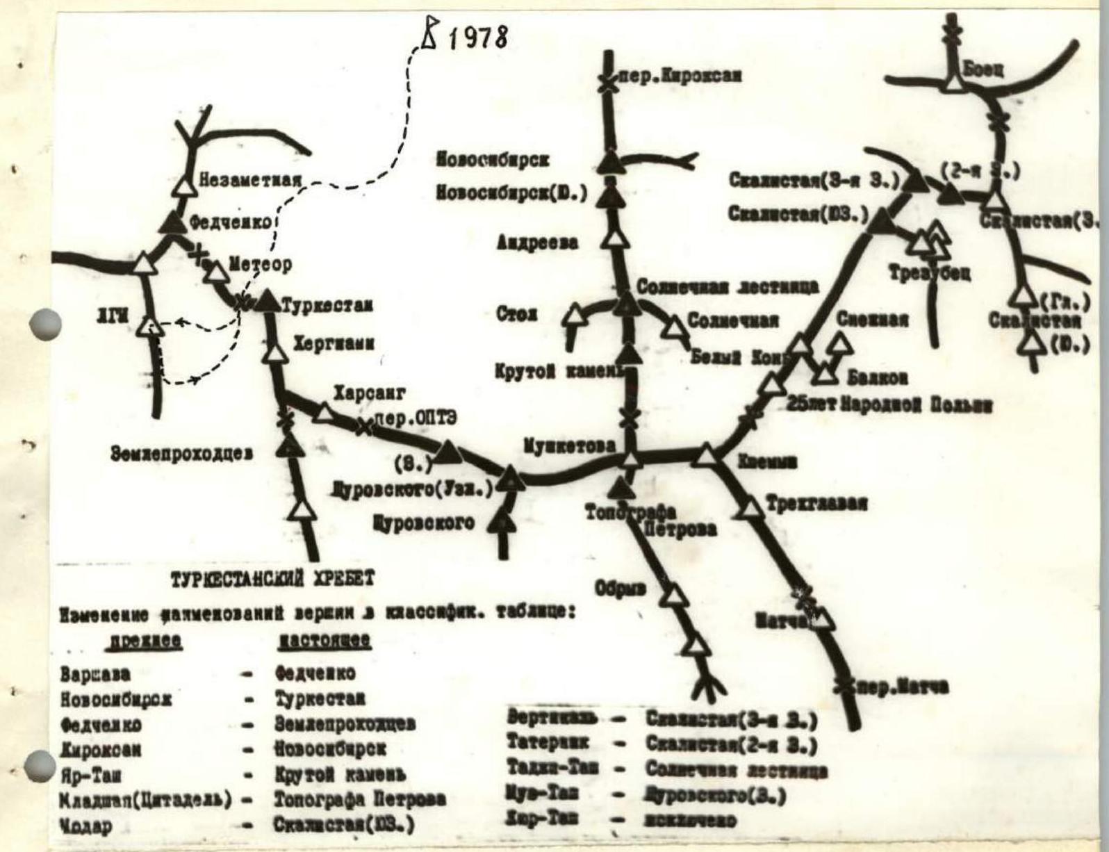
Cartographic diagram of the high-mountain node "Matcha."
Route of ascent — base camp 1978.
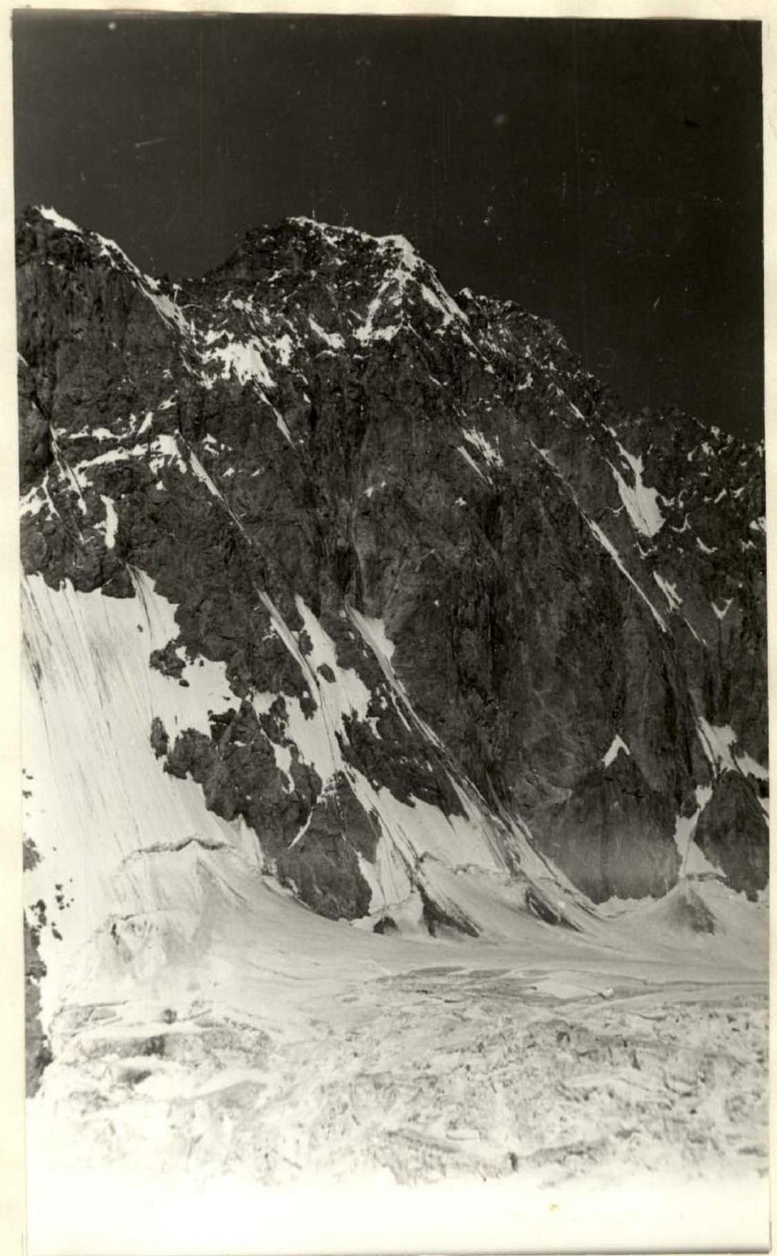
Profile of the route. View from the south (Tolstoy Glacier).
Additionally, a group from the Novosibirsk Regional Sports Committee, which was at the Koroleva Pass at that time, also maintained communication with the team (via "Vitalka") and the observation group. The observation group consisted of:
- Matveenko V.A. — Master of Sports, 1st release of the training camp.
- Khusainov R.A. — Candidate Master of Sports, head of the rescue team.
- Sedychchenko B.N. — 2nd sports category, doctor.
- Andreeva T.N. — 1st sports category.
- Dikovsky A.Ya. — 1st sports category.
- Solovyov A.G. — 2nd sports category, radio operator.
Ascent Description
I. Processing Section
July 22
The first section is snowy. The approach to the route is via a simple snowy slope (30° steepness) between two avalanche cones strewn with stones (photo 2). Crossing the bergschrund did not pose any problems — a convenient path began right at the start of the route: on the right side of the bergschrund under the "Ptitsa" (Bird) it turns into a narrow randkluft, and the transition to the rocks occurs without difficulty. Further, the first rope team went in caligae all the way to the end of the rocky ridge.
Second Section.
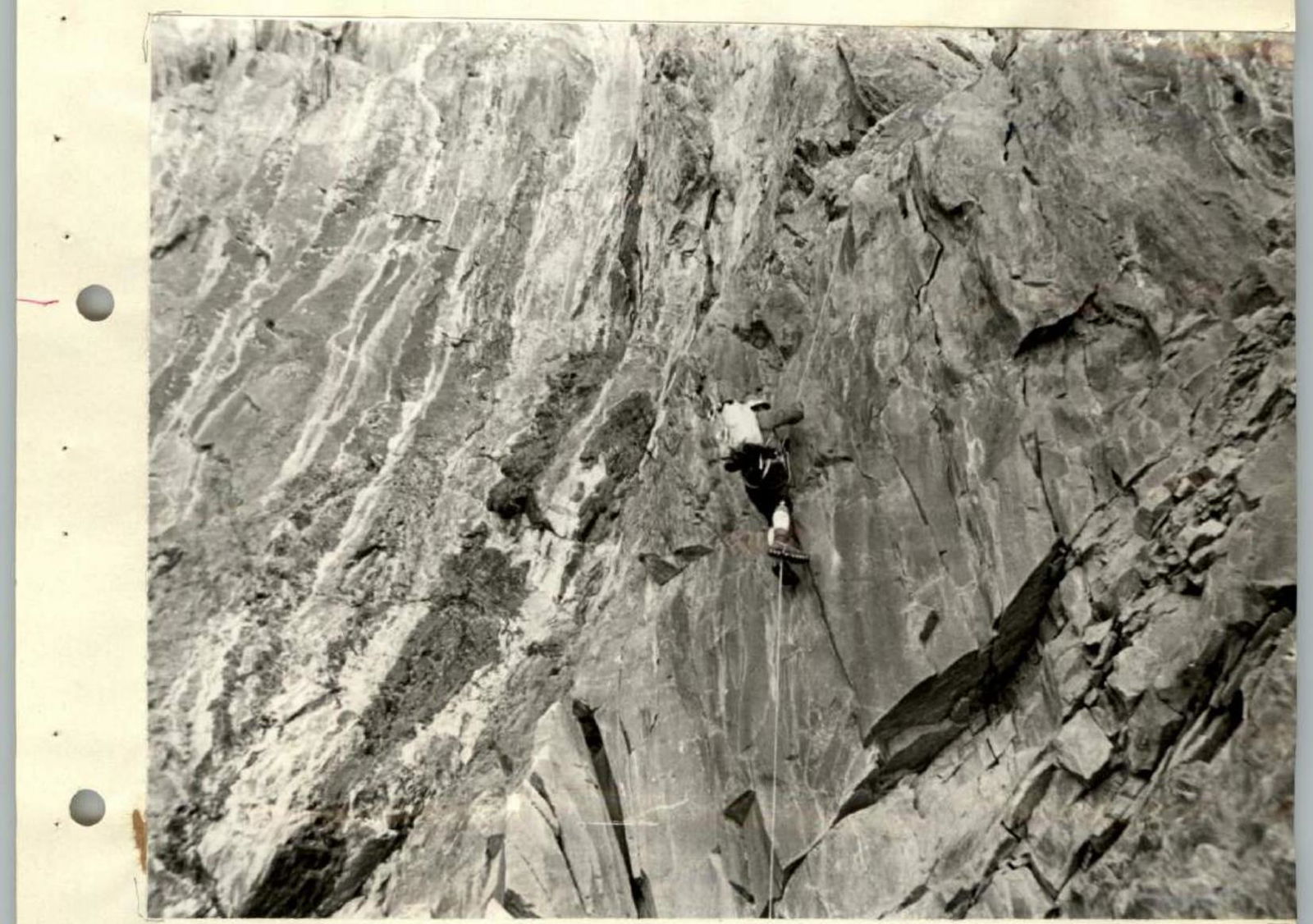
From the start of the route, traverse along the rock wall to the left onto detached feathers and further around the corner onto the right wall of the inner corner 1. Along the wall (80°) further to the left (5 m) into the inner corner and up the corner (6 m) and traverse (5 m) to the right onto the top of the wall. Further 15 m along the ridge and exit into couloir 2 with signs of rockfall. Along the couloir 20 m up its left side and then to the right up onto the wall (5 m, 75°) and further along an inclined slab (15 m) onto a ledge 3 under an overhanging stone. A total of 10 pitons were driven on this section.
Rocks fall from couloir 2 (mainly from those working above). In the future, movement of all participants along this section was along a fixed rope with crossing the couloir in its middle part.
Third Section.
From ledge 3, bypass the overhang to the right (10 m) and further up (couloir 2 ends here) along the rocks 15 m with a steepness of 60° to a complex wall 4 with an overhang. The wall is climbed on its right side: a vertical section 10 m, an overhanging section 2 m. Then traverse to the left-up (5 m, 80°) and 10 m to the right-up with a small overhanging section in the middle leads to a slab 5 (15 m, 70°). After the slab, another 10 m along destroyed rocks. 16 pitons were driven on this section.
This section, due to the complexity of passing its middle part, can be considered the first key section of the route.
Fourth Section.
Up along the right side of the ridge (30 m, 65°). A large number of live stones. Further to the left (10 m) under a wet wall 6 with a steepness from 75° to 90°. A 200 m suspended rope was organized to this place for pulling up loads. It is passed first on the left side (10 m) with an overhang in the middle, then traverse to the right (5 m) and up 10 m to the lower part of the "Ptitsa." To the left up 10 m — a convenient platform.
Fifth Section — "Ptitsa."
20 m along a snowy ridge (50°) to the top of the "Ptitsa." Here, the slope becomes gentler, and there is a convenient place for a tent. A platform for the tent is dug out in the firn. 8 safety pitons were driven.
Sixth Section — chimney.
Passing the sixth section, as anticipated, turned out to be one of the main problems of the route. Several options were considered and discussed (A, B, C, D in photo 2). As a result, option A was chosen: along chimney 7, starting about five meters to the right of the upper part of the "Ptitsa." The first 30 m of the chimney are a vertical section. The middle part of the chimney 7a is a rocky cornice with a total overhang of about three meters and a length of 10 m. It is passed on ladders. The last 30 m of the chimney with a steepness of 75–80° lead to a platform 8. A total of 22 pitons were driven in the chimney. At this point, the route processing was completed.
July 23
At 6:00, the first foursome departed for the route and by 10:00 had ascended via the fixed ropes to the "Ptitsa." At 12:00, the first twosome (Budyanov–Gutin) ascended (using jumars) along the chimney to platform 8. Six meters to the left of the upper point of the chimney (around the corner), a more convenient platform was found, and a rope was thrown over to organize a path (2) for pulling up rucksacks and fixed ropes for a simpler and faster exit for the participants (along "free" fixed ropes). After this, the first twosome proceeded to further passage of the route.
Seventh Section.
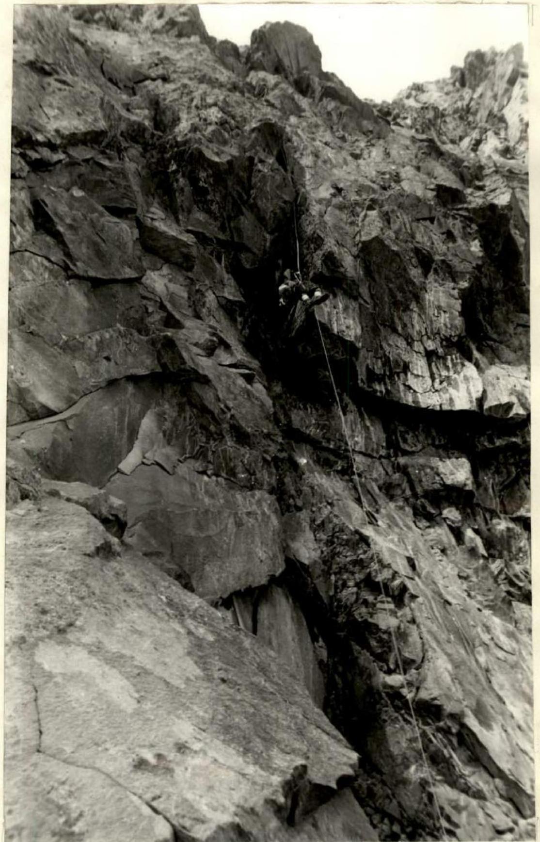
From platform 8 along the right side of the rocks onto the wall. Movement upward along a not very distinct inner corner 9 (steepness 90°) on ladders to a smooth overhang. From here, a transition (on ladders) to the right (2 m) into the next inner corner 10 with an overhang. It is passed again on ladders. After the inner corner, there is an exit onto a wide rocky wall with a steepness of about 80° with monolithic rocks. The apparent path to the right upward (II) turned out to be difficult to pass. It was necessary to return (photo 2) and pass the wall on the left side (15 m) with an overhanging section 12 at the bottom of this segment. At the top of the wall, there is a convenient ledge 13 for pulling up rucksacks. 15 pitons were driven.
Eighth Section.
Along the ledge, traverse to the left 5 m, and around the corner, a good ridge (70°) opens up, turning into a wet chimney with a steepness of 80° with good handholds. Transition to the ridge through a gap along monolithic rocks using ladders. Further along the ridge and chimney 40 m, to the right 5 m, and exit under a small wall (5 m). The first person passed it on the left along the corner. In the future, the wall was traversed along its lower part via fixed ropes. To the right of the wall, there is a wide inclined platform 14 with two tiers. On the upper tier, under overhanging rocks, a small snowy patch and an inclined slab (25°) were found. It was decided to spend the night here. 9 pitons were driven on this section. The upper tier was well protected from rocks by overhanging rocks above. The lower tier was more convenient for a tent but was exposed to rockfall. The night was not very comfortable: it was necessary to sleep semi-sitting and across the tent. The second foursome, taking into account the experience of the first, spent the night on a more convenient platform 40 m higher. The first foursome worked for 11 hours on this day. The second foursome departed from the glacier at 14:00 on the same day, ascended to the "Ptitsa" by 18:00, and spent the night there.
July 24
The first foursome, which spent the night on inclined ledge 14, departed for the route only at 9:30 after a poor night. At 10:00, during communication with the observers, the group's location was clarified. The first rope team to depart after the night was Gutin–Budyanov.
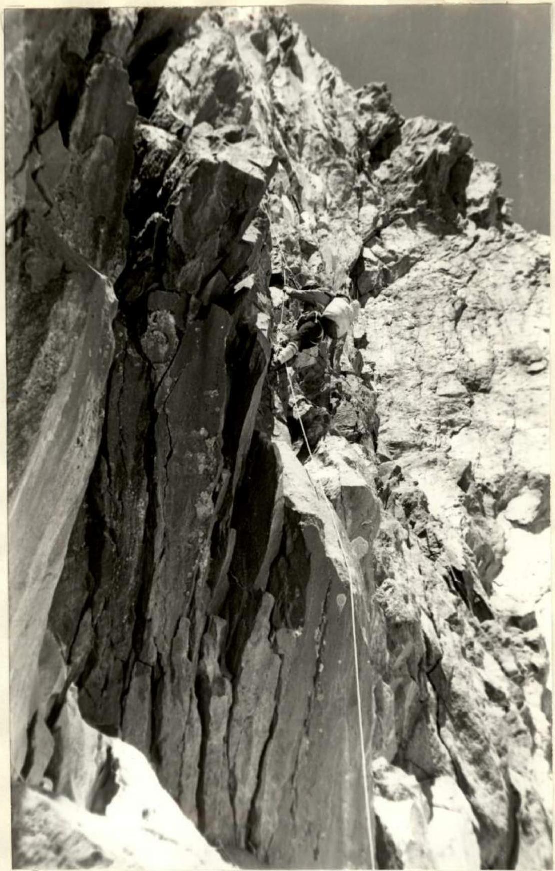
Ninth Section.
First, along the right side of the wall (8 m) above platform 14. Further, overhanging rocks with a length of 3 m are passed on ladders, and then along the wall to the left 25 m with a steepness of 90°, and an exit onto a good ledge 15, convenient for pulling up rucksacks and spending the night (this was the second night for the second foursome). From here, a path (4) was organized for pulling up rucksacks: 25 m from platform 14. From platform 15 upward, a couloir (25 m) with a width of 3–4 m and a steepness of initially 90°, then 75° departs. The couloir abuts a wall, to the left of which a wide inclined slab with a steepness of 50° is adjacent. Along it, traverse to the left-up 15 m, and then to the right along a vertical wall (3 m) onto a platform under an overhanging wall. 15 pitons were driven.
Tenth Section.
To the left upward along the overhanging wall, a couloir with glacier ice departs (steepness from 45° to 75°), along which the further route proceeds. The overhanging wall to the right ensures complete safety from possible rockfall. The first 20 m are rocks with ice, further 20 m the couloir has smooth rocky slabs, after which the chimney ends with a narrowing and a five-meter overhanging wall. The overhang is passed on ladders. Further 15 m of gentle destroyed rocks (50°) and to the right upward, a rocky chimney departs again. At its beginning, to the left, there is a good safe ledge with a width of 50–60 cm. Here it is convenient to gather the entire group. 12 pitons were driven on this section.
Eleventh Section.
The first to pass on this section was Saratovkin. From the ledge 20 m upward along the chimney (steepness 80°) under an overhanging wall. Many live stones. Under the wall, traverse to the left 10 m along destroyed rocks, then 5 m upward onto a horizontal ledge 16 with a width of about a meter. The ledge is located in a cirque — on gray rocks characteristic of a cirque. From the ledge upward along a vertical wall 15 m to an inclined platform 17. 10 pitons were driven on this section. Above platform 17, many large live stones hang, so it was decided to spend the night on ledge 16. The night was sitting, but quite comfortable; two people were even able to sleep lying along the ledge. Additionally, there is a convenient niche for a kitchen on the ledge. It is not possible to set up a tent on the ledge: it simply blocked the ledge from the open side. The first foursome worked on the route for 8 hours and 30 minutes on this day. The second foursome ascended to platform 15 on the same day and spent the night there.
July 25
The first foursome departed for the route at 8:20 in the morning. The Budyanov–Saratovkin rope team worked ahead.
Twelfth Section.
From ledge 17 along the right side of the wall upward 5 m (steepness 80–90°) to a vertical wall with a slit into which a hand can be wedged, and eccentrics can be placed well. The wall (15 m) leads to a wide inclined platform-slab 18. 6 pitons were driven.
Thirteenth Section.
To the left of platform 18, a wide (3–4 m) couloir 20 with a steepness of 80° begins. The transition from platform 18 into the couloir (8 m) along smooth steep slabs at the bottom or along a vertical wall in the middle of the platform is complex. On the right side of the platform, a detached feather 19 was found, going from right to left and leading to the top of the smooth wall into the middle of couloir 20. The feather has smoothed walls, and climbing it is quite challenging (using eccentrics). Further 10 m upward to the right along the couloir and then along its left vertical wall (3 m) onto an inclined slab 21 with wide cracks (steepness 75°). Here, a point for receiving rucksacks was organized — path (5). 8 m along the slab to the left-up and 2 m upward lead to wide talus ledges, from which the rocky ridge to the right of the large rocky tower 22 is visible. 8 pitons were driven on this section. On the talus ledges under tower 22, it was possible to lay out platforms for two tents; at this point, both foursomes joined and moved together further. The working hours on this day were 8. A control cairn was built on the platform under tower 22. On the same day, another 80 m rope was hung from the night's location.
Fourteenth Section.
First, 30 m along a wide slab (35°) onto the ridge before tower 22. Then bypass tower 22 to the right along destroyed rocks 20 m and further traverse along smooth slabs with ice: 30 m, steepness 50–60°. 6 pitons were driven.
July 26
The Vodop'yanov, Prokopenko, Budyanov threesome worked ahead.
Fifteenth Section.
Exit onto the ridge behind rocky tower 22. Upward along slabs 30 m with a steepness of 80–90° onto the ridge. At the top, there is ice; 8 pitons were driven, and steps were cut.
Sixteenth Section.
Along the ridge 60 m with a steepness of 48–55°. The ridge is sharp with numerous walls and abuts an overhanging wall 23 (2 m), after which a simple ridge section (35 m) leads under a rocky ascent cut by a wide couloir 24. 10 pitons were driven.
Seventeenth Section.
Along the left side of couloir 24 along smooth rocks (steepness 65°) type "ram's foreheads" 20 m to a platform 25 convenient for receiving rucksacks. Further, the route goes along a steep (average steepness 75°, with an overhang in the middle) rocky forehead 26 with a length of 30 m with smooth rocks. The forehead is passed almost centrally on ladders along a small intermittent crack into which mostly petal pitons are driven. After passing the cornice at the top — traverse to the left (5 m) onto a ledge 27, convenient for receiving rucksacks: here another path is organized for pulling up rucksacks. The section is considered one of the key ones on the route. 20 pitons were driven.
Eighteenth Section.
From ledge 27 — bypass the upper part of rocky forehead 26 along destroyed rocks 15 m with an exit to the top of the rocky forehead. From here upward, a couloir with a width of about ten meters departs, with a steepness of initially 45°, then up to 75°. At the bottom, the couloir is rocky, with dirt, water, and glacier ice, and sometimes with vertical sections. After 60 m, the rocky outcrops end, and further, an ice slope between two steep snowy ridges begins. 10 pitons were driven.
Nineteenth Section.
Along the ice slope with a steepness of 65° (on crampons) with step cutting and screw placement — traverse of the ice slope 25 m to the left-up. Upon exiting onto the ridge, the slope's steepness reaches 90°. Then upward 20 m along a snowy ridge. Movement along the ridge is complicated by its steepness (up to 50–60°), as well as cornices on the left and an ice wall on the right. The snow on the ridge is very loose, and forward progress is essentially reduced to digging a trench. After 20 m on the ridge, in a slight flattening, two platforms 28 were cut at different heights for tents. On the same day, fixed ropes were hung along the snowy ridge up to cornice 29, located at the point where the left and right snowy ridges meet. From platforms 28 to cornice 29, there are about forty meters. A total of four ice screws were placed on this section. On this day, the team worked for 10 hours.
July 27
The team departed late (at 10:00), but a good breakfast was prepared (cottage cheese, puree, caviar), ensuring high efficiency. The Prokopenko V.–Vodop'yanov rope team worked ahead. The entire day, movement was on crampons using ice axes and hammers with anchor beaks. V. Prokopenko, who was leading, wore 12-tooth crampons. From the night's bivouac on platforms cut into the ridge (see photo 2) — exit to the right-up along a sheer firn wall (2 m) onto a snow-ice ridge. 40 m along the fixed rope hung the previous evening under the locking cornice 29. Photographs of the wall (2) were taken during the group's passage of sections 19–21. On platform 28, one tent is still visible, not yet dismantled. Figures of two people are visible near cornice 29, and one person is visible at the beginning of the 20th section. The first person is visible on the snowy ridge at the end of the 21st section.
Twentieth Section.
Bypassing cornice 29 to the right turned out to be labor-intensive due to the very steep (70°) ice slope on the right. Therefore, the route was laid to the left along the ice slope with a steepness of about 50°. Initially, a rappel from the cornice to the left (dü; 3–4 m) and further traverse of the ice slope (person in the photo) with ascent under a rocky wall composed of destroyed rocks (2 ice screws). Without stepping onto the rocks (due to rockfall danger), movement proceeds along steep ice walls along the rocks. Insurance is on rocky pitons and stoppers. The length of the section is 80 m; the following were used:
- 3 ice screws,
- 2 rocky pitons,
- 1 hexa.
Twenty-first Section.
Bypassing rocky sections to the left along the ice, the route enters a narrow throat of a steep (up to 75°) couloir 21. Upward to the right along the ice, sometimes on-glacier ice. Exit from the narrow couloir under the cornices of the ridge. Along a steep groove with an icy bottom and firn walls, leaving the cornices to the right, ascent to the junction of the left and right edges of the cirque. Movement involves elements of chimney technique. Insurance is through ice screws screwed into the groove's bottom. If the variant of ascent to the summit along the left edge of the cirque had been chosen, the routes would have coincided at this point (upper person in the photo). On this section:
- 6 rocky pitons were driven,
- 2 loops were used,
- 5 ice screws were used.
Twenty-second Section.
The route (80 m) goes along ridge 32 in the direction of the summit. After overcoming two small breaks in the ridge with cornices — exit under a large overhanging cornice 33 with a crack at the base and very picturesque icicles. Insurance is through ice screws — 6 pieces.
Twenty-third Section.
Reconnaissance of bypassing the cornice to the right gave negative results: the sub-cornice crack was widening, and the bypass was problematic. At the same time, the left slope of the ridge ceased to be a wall. It was decided to cut a window in the cornice to exit onto the ice slope of the ridge.
By this time, the sun had softened the firn, and the work on cutting the window was not too labor-intensive. Snow obtained from cutting was used to build a bridge over the crack.
Through the window — exit onto the left, covered with small cal-gosopores, firn slope. Further — along the upper edge of destroyed, not very steep rocks (insurance through outcrops, loops) — into the far, in the direction of travel, corner of the ice slope descending from under the cornice-summit ridge (60 m).
Here:
- an ice piton;
- ascent straight up (60 m) along the ice onto the destroyed rocks emerging from the ice (insurance through outcrops).
The length of the section is 120 m; 4 pitons were driven, 3 loops and 3 ice screws were used.
Twenty-fourth Section.
Ten meters to the left to avoid the summit cornices and straight up along a steep (60°) and then sheer firn ascent with an exit onto the summit ridge (55 m, 4 ice screws). Here:
- 5 m straight ahead — a platform (bivouac of the first ascenders — Nezamedinov's team);
- 20 m to the right — the summit cairn.
The route, which seemed hopeless to us a few years ago and then problematic, has been completed. Ahead is the descent.
In the cairn, a note from the first ascenders of 1973 — Nezamedinov's group.
The descent route along the ridge to the south:
- Initially, a simple talus ridge.
- Then 2 rappels of 40 m to the west.
- Traverse 80 m to the left.
- Again, exit onto the ridge.
Here, the team spent the night. The platform is convenient.
July 28
The path further proceeds along the ridge in the direction of the left subpeak. Exit onto it and further descent via rappel into a wide talus couloir in the direction of the southern saddle of the ridge (80 m). Traverse of the couloir and further descent along a not very distinct ridge (rappels, sports style) to a wide talus (80 m). From the talus, descent in sports style along a snowy-icy couloir with insurance on rocky walls (5 ropes). The couloir leads to the southern saddle of the ridge. From here, descent along a steep, broken glacier-halter to the Tolstoy Glacier.
The team on July 28:
- descended to the lower icefall,
- did not find a simple path through the icefall,
- spent the night, cutting platforms in the firn on a snowy cushion above the icefall.
July 29
Departed at 6:00 in the morning. After communicating with observers via radio, the descent route was clarified. It was decided to descend along the "ram's foreheads" of the lower part of the southeastern edge of Peak LGI (5 ropes). Exit onto the "ram's foreheads" through the randkluft. At 9:00 in the morning, the entire team was on the Tolstoy Glacier.
Conclusions
According to observation results, it was expected that there would be three key sections of high complexity on the route:
- Exit to the ridge through cornices under the "Ptitsa" (80 m).
- Passage of the bastion above the "Ptitsa" (240 m).
- Passage of the tower after the rocky ridge (80 m).
The "linkage" of these key sections is practically no simpler than category 5B. The passage of the route confirmed the accuracy of these assessments. The key sections turned out to be of the highest — 6th category of complexity.
The team's movement schedule along the wall practically coincided with that planned according to the tactical plan. The summit snowy-ice ridge was passed a day faster.
Overall, the route can be assessed as category 6. The successful passage of the wall was ensured by a number of techniques and the use of new technical means:
- Ice hammers with anchor beaks.
- New shock-absorbing devices.
- Devices for extracting pitons.
- Organization of rucksack pulling.
- Stereophotogrammetric method for measuring route section parameters.
TABLE OF MAIN CHARACTERISTICS OF THE ASCENT ROUTE
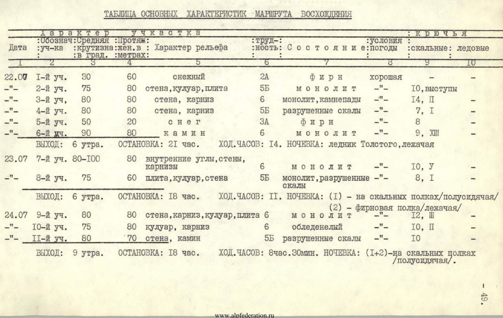
| Date | Section | Average steepness in degrees | Length in meters | Relief character | Category | State and weather | Pitons: rock | Pitons: ice |
|---|---|---|---|---|---|---|---|---|
| July 22 | R1 | 30° | 60 | snowy | 2A | firn, good | — | — |
| R2 | 75° | 80 | wall, couloir, slab | 5Б | monolith | 10, outcrops | — | |
| R3 | 80° | 80 | wall, cornice | 6 | monolith, rockfall | 14, P | — | |
| R4 | 80° | 80 | wall, cornice | 5Б | destroyed rocks | 7, I | — | |
| R5 | 50° | 20 | snow | 3А | firn | 8 | — | |
| R6 | 90° | 80 | chimney | 6 | monolith | 9, XIII | — | |
| DEPARTURE: 6:00 | STOP: 21:00 | WORKING HOURS: 14 | OVERNIGHT: Tolstoy Glacier, lying down | |||||
| July 23 | R7 | 80–100° | 80 | inner corners, walls, cornices | 6 | monolith | 10, У | — |
| R8 | 75° | 60 | slab, couloir, wall | 5Б | monolith, destroyed rocks | 8, I | — | |
| DEPARTURE: 6:00 | STOP: 18:00 | WORKING HOURS: 11 | OVERNIGHT: (1) — on rocky ledges/semi-sitting/ (2) — firn ledge/lying down/ | |||||
| July 24 | R9 | 80° | 80 | wall, cornice, couloir, slab | 6 | monolith | 12, Ш | — |
| R10 | 75° | 80 | couloir, cornice | 6 | iced | 10, P | — | |
| R11 | 80° | 70 | wall, chimney | 5Б | destroyed rocks | 10 | — | |
| DEPARTURE: 9:00 | STOP: 18:00 | WORKING HOURS: 8 h 30 min | OVERNIGHT: (1+2) — on rocky ledges/semi-sitting/. | |||||
| July 25 | R12 | 80° | 35 | wall, slabs | 5Б | monolith | good 6, hexa | — |
| R13 | 70° | 80 | chimney, couloir | 5Б | monolith, destroyed rocks | 8, hexa | — | |
| R14 | 35° | 80 | slabs | 5А | iced rocks | 6 | — | |
| DEPARTURE: 8:00 | STOP: 17:00 | WORKING HOURS: 8 | OVERNIGHT: on a rocky ledge, lying down. | |||||
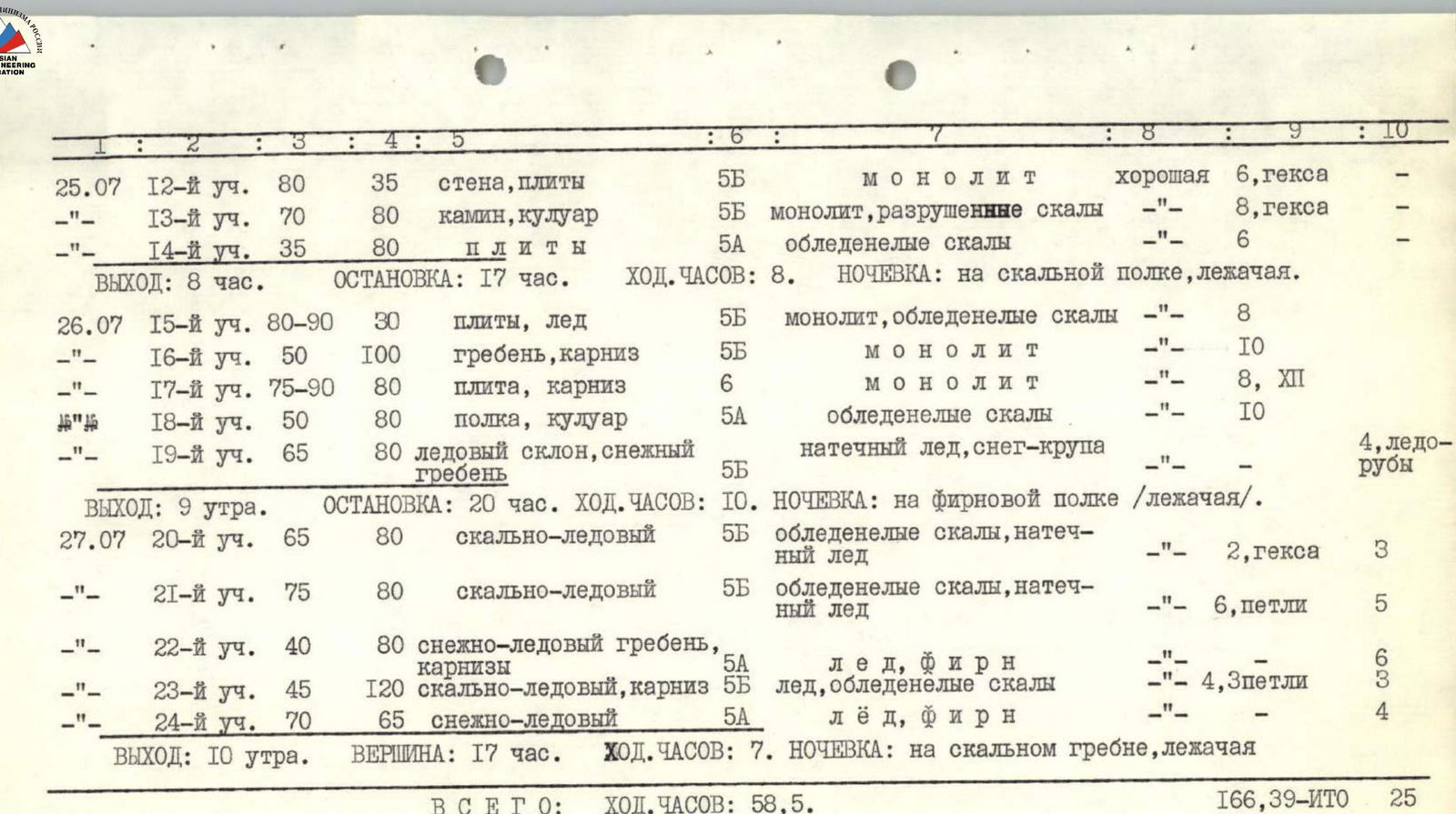
| July 26 | R15 | 80–90° | 30 | slabs, ice | 5Б | monolith, iced rocks | 8 | — |
| R16 | 50° | 100 | ridge, cornice | 5Б | monolith | 10 | — | |
| R17 | 75–90° | 80 | slab, cornice | 6 | monolith | 8, XII | — | |
| R18 | 50° | 80 | ledge, couloir | 5А | iced rocks | 10 | — | |
| R19 | 65° | 80 | ice slope, snowy ridge | 5Б | glacier ice, snow-gravel | — | 4, ice screws | |
| DEPARTURE: 9:00 | STOP: 20:00 | WORKING HOURS: 10 | OVERNIGHT: on a firn ledge/lying down/. | |||||
| July 27 | R20 | 65° | 80 | rocky-ice | 5Б | iced rocks, glacier ice | 2, hexa | 3 |
| R21 | 75° | 80 | rocky-ice | 5Б | iced rocks, glacier ice | 6, loops | 5 | |
| R22 | 40° | 80 | snowy-ice ridge, cornices | 5А | ice, firn | 6 | — | |
| R23 | 45° | 120 | rocky-ice, cornice | 5Б | ice, iced rocks | 4, 3 loops | 3 | |
| R24 | 70° | 65 | snowy-ice | 5А | ice, firn | 4 | — | |
| DEPARTURE: 10:00 | SUMMIT: 17:00 | WORKING HOURS: 7 | OVERNIGHT: on a rocky ridge, lying down. | |||||
| TOTAL: | WORKING HOURS: 58.5 | 166, 39 ITO | 25 |
Second section. Beginning of the rocky part of the route. First 80 m rope.
Sixth section. Passing the cornice above the "Ptitsa" on jumars.
Seventh section. Rocky wall after the chimney above the "Ptitsa."
![img-8.jpeg]({"width":157,"height":147,"