
- Class of ascent — traverse
- Area of ascent — Pamir-Alay, Turkestan Range
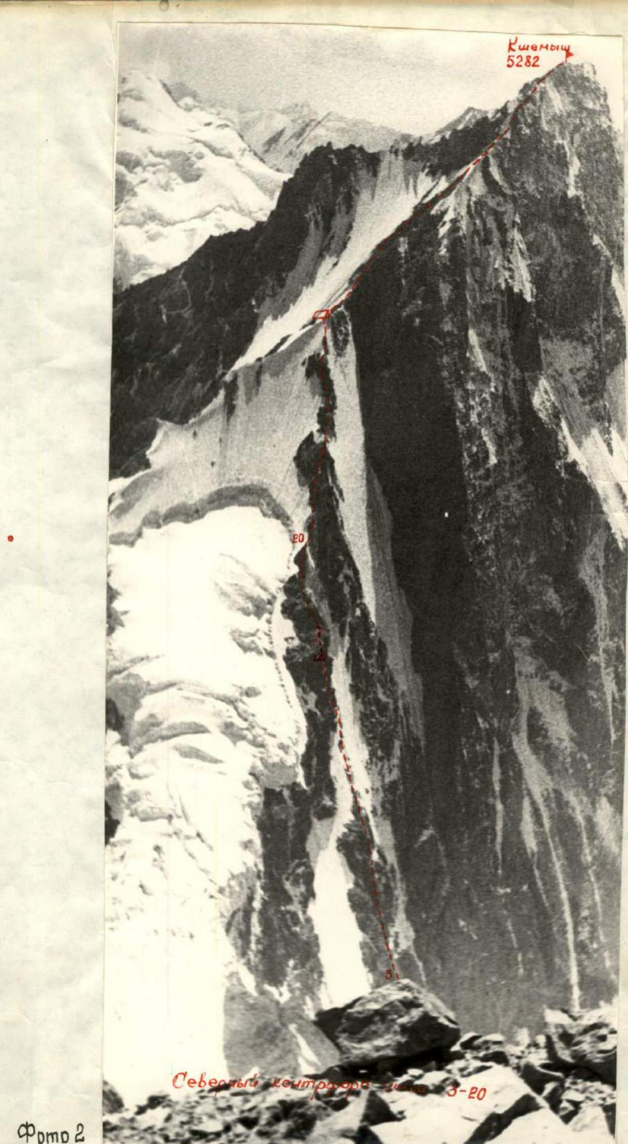
- Route of ascent — Kshemyysh — 5282 m (via N. buttress), Mushketova Southern — 5200 m, Mushketova Northern — 5150 m, Mushketova Predvershinnaya — 5019 m, Shchurovsky Malyy — 5100 m, Muztash — 5100 m, Kharsang — 4800 m, Fedchenko — 5409 m.
- Characteristics of ascent:
- height difference of the N. buttress — 570 m
- average steepness of the N. buttress — 55–58°
- length of difficult sections
- 5 km cat. dif. — 2318 m
- 5–6 km cat. dif. — 222 m
- 6 km cat. dif. — 34 m
- Pitons driven:
- rock — 269
- ice — 76
- Number of climbing hours — 102.5
- Number of nights and their characteristics — 13, directly on the traverse — 9, of which 1 was a sitting bivouac.
- Team name: Team of the Leningrad City Committee for Physical Culture and Sports.
- Full name of the team leader, participants, and their qualifications:
- captain — NEZAMETDINOV Aidar Barievich — Master of Sports of the USSR
- participants — PULINETS Yury Semenovich — Master of Sports of the USSR
- IVASHEV Vadim Kornilovich — Candidate for Master of Sports
- MARKOV Dmitry Prokofievich — Candidate for Master of Sports
- Team coach — Pulinets Yury Semenovich, senior instructor.
- Dates of departure and return: 14–27 August 1973
Brief geographical description of the ascent area. Matcha Highland Node
To the south of the Fergana Valley, a continuous chain of peaks stretches for over 700 km. The eastern half is known as the Alay Range. Almost exactly in the middle, the chain bifurcates, forming a giant fork, inside which lies the Zarafshan Valley. The northern branch of this fork is the Turkestan Range, and the southern one is the Zarafshan Range. From the latter, further west, the Gissar Range branches off, completing the formation of a trident. Geologists include it in the Western Tian Shan system, while mountaineers call it the Pamir-Alay.
The junction of the three ranges — Alay, Turkestan, and Zarafshan — is known as the Matcha node. It is indeed a node with intricate interconnections of ridges and spurs, between which numerous glaciers lie. The largest of these is the Zarafshan Glacier, stretching about 28 kilometers, and the most inaccessible is the Raygorodsky Glacier, which descends in a picturesque icefall towards the emerald shores of Lake Kara-Kul-Katta ("Big Black Lake" in Kyrgyz). Exactly at the junction of the three ranges lies the peak Iglа.
Four main valleys are located in the Matcha node.
- Two of them, the Kshemyysh and Dzhiptyk rivers, flow from the Turkestan Range to the north, forming the Isfara River.
- The third valley, the Ak-Terek River, begins under the slopes of Skalisty Peak, initially moving in a wide arc to the southeast and then gradually turning east and northeast, connecting with the Sokh River valley.
- These rivers belong to the Syr Darya basin.
- Finally, the fourth valley, the Zarafshan River, stretches strictly to the west.
The passes connecting the valleys are not simple and have elevations of 3900–4300 m.
The highest point in the area is the Main peak of the Skalisty massif (5650 m), located in the Ak-Terek spur of the Turkestan Range. Other significant peaks in the area include:
- Akhun (about 5200 m) — Zarafshan Range,
- Peak Shchurovsky (5560 m) — Turkestan Range,
- Dong-Chad (about 5300 m) — Alay Range.
Matcha is not only a node of three ranges but also of three Central Asian republics. The upper reaches of the Zarafshan River are in Tajikistan, the Kshemyysh and Ak-Terek valleys are in Kyrgyzstan, and the areas of mountain pastures, the Sokh and Sisfor valleys, are in Tajikistan and Uzbekistan, where field farming and horticulture thrive.
Historical excursus
The first researcher to visit the Matcha mountain node was Alexey Fedchenko. A graduate of Moscow University and a biologist by training, Fedchenko was seriously interested in anthropology, paleontology, and geology. Therefore, his research was, as they say now, "comprehensive." In 1869–1871, he lived and worked in Central Asia, studying the flora and fauna of the region from Samarkand to the Alay Valley. He is also credited with the discovery of the Trans-Alay Range and its highest peak, 7134 m (now known as Lenin Peak).
In June 1871, Fedchenko penetrated the upper reaches of the Isfara River and on June 24 ascended to the glacier in the upper reaches of the Dzhiptyk valley, which he named after his teacher, the renowned geologist and paleontologist G. E. Shchurovsky, one of the organizers of Fedchenko's expeditions. At the same time, Olga Fedchenko, the traveler's wife and constant companion, created her famous drawing "Shchurovsky Glacier and the sources of the Isfara River." It depicts three peaks named after Shchurovsky:
- Main,
- Uzlovaya,
- Zapadnaya (now called Muz-Tash).
Fedchenko's expedition laid the foundation for the study of the Matcha mountain node.
In 1880, a large expedition led by I. V. Muskhetov, a well-known explorer of Central Asia, traversed the Zarafshan Glacier, passing from the Zarafshan Valley into the Ak-Terek-Sokh Valley. The expedition conducted a topographic survey of the glacier, resulting in the naming of glaciers such as Tolstoy, Skachkov, and Mir-Amin, as well as peaks like Iglа, Obryv, Belaya, Akhun, and Golova.
In 1933–1934, one of the teams of the Tajik-Pamir Expedition of the USSR Academy of Sciences explored the Matcha node, visiting the Kshemyysh, Raygorodsky, and Zarafshan glaciers, among others. Climbers traversed the Shchurovsky Glacier to reach the Zarafshan Glacier, naming the challenging pass they conquered "OPTPE" — "Pamir-Tajik Expedition Team." The Matcha pass was also traversed.
In 1934–1935, climbers, including the Abalakow brothers and A. Maleinov, participated in the exploration and development of tin deposits on the Olovyannaya mountain in the Turkestan Range. They managed to make several ascents, including one to Peak Granitny (5056 m) in the Myn-Teko valley.
In 1940, the Moscow House of Scientists' mountaineering expedition, led by V. V. Nemtsky, operated in the Matcha node. Climbers visited the Zarafshan Glacier, conquered Peak Matча, and traversed from the Kshemyysh valley to the Ak-Terek valley via a pass that was subsequently named after the group's leader, A. I. Ivanov. A challenging pass route was undertaken in the upper reaches of the Utronn and Raygorodsky glaciers. Three climbers — Mukhin, Gusev, and Popov — ascended Peak 5800 (according to their measurements) in the Ak-Terek spur, likely one of the main peaks of the Skalisty massif.
After the war, mountaineering groups led by A. Zyryanov (1955) and Bleshchunov (1958) visited the Matcha node area but did not undertake any ascents.
The primary mountaineering exploration of the area was conducted by climbers from Novorossiysk's "Vertical" mountaineering club. Their expeditions (1969–1970 and 1971) resulted in significant ascents and the conquest of most of the peaks in the Turkestan Range and its spurs. Their efforts led to the inclusion of 47 routes to the main peaks of this region in the USSR's mountain vertex classification table.
However, there is still much to be explored in this mountainous region. This mountain country undoubtedly deserves thorough investigation and study.
Matcha awaits its first ascenders.
In fact: 4th, 3rd, and 2nd cat. dif. Peak Shchurovsky Malyy was climbed for the first time. The route is a combination of rock and ice climbing, with snow or firn sections rarely encountered. The route featured a full arsenal of rock relief: slabs, chimneys, ice-covered walls, couloirs, etc., but predominantly consisted of heavily destroyed, jagged ridges with an abundance of gendarmes. Ice sections were equally varied, involving both ridge and steep slope traverses, as well as ascents and descents, with the latter often being significantly more challenging and time-consuming, especially along the ridge.
During the traverse, the weather was quite favorable, resulting in high productivity each day. The average duration of work on the route was 11 climbing hours per day, with a maximum of 14 hours and 25 minutes and a minimum of 8 hours and 25 minutes per day.
Thus, the combination of the technically very complex N. buttress and the physically and technically demanding 10-kilometer ridge, complicated by altitude and numerous challenging sections, both rock and ice, justifiably places this traverse among the best in the Soviet Union, and, in the group's opinion, the route is of the highest — sixth category of difficulty.
III. Brief description of ascent conditions
The base camp of the Leningrad Mining Institute's mountaineering expedition, to which the team belonged, was located in a good juniper forest, about a 2-hour walk from the tongue of the Kshemyysh Glacier, at the site of the "Vertical" Club's base camp in 1969.
To reach the base camp from the nearest railway station, Kanibadam, one can follow these steps:
- Take the train to Kanibadam station;
- Then travel by foot or vehicle to the base camp.
Kanibadam — district center Isfara — 20 km — bus — 0.5 hours. Isfara — Vorukh village — 48 km — bus — 1.5 hours. Vorukh — Mazār tract — 14 km — random vehicles — 1 hour. Mazār — base camp — good trail — packhorses — 8 hours. The nearest mountaineering camp, "Dugoba," is approximately 150 km away.
The mountains of the Matcha node are of the Alpine type. With sharp and pointed outlines, they remain above 3500 m over a significant distance. The snow line on the northern slope is at 3500–4000 m, while on the southern slope, it is slightly higher due to the dry climate. The Turkestan Range is composed primarily of:
- siliceous and clay shales,
- sandstones,
- limestones,
- marble,
- granite,
- syenite,
- gabbro,
- fluorite.
Due to the combination of such diverse rock types in terms of strength and the sharply continental climate, the rocks are heavily weathered, and there is a significant rockfall hazard. This summer was particularly hot and dry, causing the slopes to clear of snow, increasing the complexity of ice routes and significantly heightening the rockfall danger in the area.
The climate of the node is moderately continental, and in the foothill regions, it is moderately warm. There is an abundance of sunlight, with an average annual duration of sunshine being 2500–2700 hours (compared to about 1600 hours in Moscow).
- Summer is short but not sultry.
- Winters in the mountains are cold, with frosts.
One of the climate's features is the uneven distribution of precipitation across the territory. In nearby locations, weather conditions can vary significantly on the same day. Often, it is warm and clear in the valley, while the peaks of neighboring mountains are shrouded in clouds, with rain or snow falling.
During our stay in Matcha from July 21 to August 29, the weather was generally stable and good. However, there were three instances of sharp weather deterioration, each lasting about two days:
- July 26–27
- August 7–8
- August 15–16
Our departure for the route coincided with a period of deteriorating weather, forcing us to wait for two days. However, during the traverse, the weather remained good and stable.
The approach routes to the beginning of the route and to the main peaks of the area can be divided into two sections:
- From the base camp to the "Sunny" bivouac, located under the slopes of Solnechnaya peak, it takes about 5–6 hours of walking with a backpack.
- The return journey takes 3–4 hours.
- From the "Sunny" bivouac to the start of the route, it generally takes no more than 2–3 hours.
The approach from the "Sunny" bivouac to the beginning of the N. buttress of Kshemyysh peak took 30 minutes across the open, flat Kshemyysh Glacier.
The descent from the OPTPE pass to the Shchurovsky Glacier and the transition through the Shchurovsky pass back to the "Sunny" bivouac took 6 hours.
IV. Training and reconnaissance exits
The team arrived in the Matcha area on July 22, consisting of 9 people: Nezametdinov A. B. — captain, Zakhzhiy M. M. — deputy captain, Pulinets Yu. S. — coach, and team members: Verzhlesov F. V., Ivashev V. K., Krapivin V. N., Litvak I. L., Markov D. P., Cherepanov V. A. Almost all team members were coaches in the mountaineering expedition and conducted training with their groups. However, the team conducted a few specialized training sessions together: on July 24 and 28.
On July 23, Zakhzhiy and Markov conducted the first reconnaissance of Kshemyysh peak from the north, ascending to the "Sunny" bivouac.
On July 26, Nezametdinov and Litvak surveyed and photographed the visible part of the Turkestan Range from the Kirokhan pass.
On July 28–29, Litvak and Pulinets, as part of a sports group, made a reconnaissance exit under the wall of Kshemyysh to study rockfall danger and photograph the area.
From July 30 to August 8, Nezametdinov, Markov, Ivashev, and Verzhlesov undertook a training ascent to Kirokhan peak — 2A cat. dif. and a first ascent to the Leningrad Mining Institute peak (LGI), approximately 5B cat. dif.
On August 3–4, Cherepanov and Zakhzhiy observed the N. wall of Kshemyysh and surveyed the traverse from the Shchurovsky pass.
From August 6 to 11, while leading sports groups, Pulinets, Zakhzhiy, Litvak, Cherepanov, and Krapivin were in the high-altitude zone near the "Sunny" bivouac and, with their sports groups, completed:
- Ice training on August 6 and 7.
- On August 8, Pulinets and Zakhzhiy made a supply drop of 15 kg of food and fuel to the N. E. ridge under the Dvurogiy Gendarme.
- On August 8–10, Krapivin, with his sports group, ascended Kharsang peak via the OPTPE pass, 3A cat. dif., and made a supply drop of 12 kg of food and fuel to the slopes of Kharsang peak.
- On August 9, Pulinets ascended Yar-tash peak, 3A cat. dif.
- On August 9, Zakhzhiy ascended Tajik-tash peak, 2B cat. dif.
- On August 9–11, Cherepanov traversed Tajik-tash and S. Andreyev peaks, 4A cat. dif.
- On August 8, Litvak ascended Stol peak, 2B cat. dif.
Thus, all team members, through reconnaissance exits, training ascents, and supply drops, acclimatized well, thoroughly examined the traverse route, chose the ascent route to Kshemyysh peak, and studied the rockfall danger of the N. buttress, becoming familiar with the area's relief and most ready to tackle such a long route.
V. Team composition
According to the 1973 USSR Alpine Championship regulations, our team was allowed to participate in the traverse category with a team of 10 people. However, only 9 people were able to travel to the Turkestan Range area, as Kazhevnik B. L. was unable to leave work.
Following reconnaissance exits, training sessions, and ascents, and considering the area's specifics and significant rockfall danger, a team of 4 was selected. This number was also determined by the need to leave an equally capable group at the base camp to ensure the team's safety and the successful completion of the mountaineering expedition.
Based on the above considerations, the coach determined the team composition for the traverse:
- First participant
- Second participant
- Third participant
Description of the route passage
August 14, 1973
Organizational matters related to leading the mountaineering expedition were largely completed, and the pair Nezametdinov — Markov left the base camp at 11:00. Their task was to re-examine the N. buttress for rockfall danger, find a safe path to cross the bergschrund, and process the upper part of the ascent.
The storm camp was already prepared at the "Sunny" bivouac, which is a convenient talus plateau (with a stream running nearby) and is located within 30 minutes' walk from the start of our route.
The journey to the bivouac from the base camp takes 5–6 hours on foot with a backpack. The route passes:
- along a trail on the left bank of the Kshemyysh River,
- a climb through the center to the terminal moraine of the Kshemyysh Glacier,
- exit to a large boulder,
- then along the orographic left side of the glacier under the slopes of Solnechnaya peak, where the "Sunny" bivouac is located on the left-bank moraine.
August 15, 1973
The weather deteriorated sharply in the morning: fog, wet snow. Reconnaissance or processing was out of the question.
August 16, 1973
The weather remained poor: rain or wet snow fell throughout the day. However, towards the evening, there was noticeable improvement: the rain stopped, and it became significantly colder.
The second half of the group — Pulinets and Ivashev — and the pair of observers — Leonov and Kuznetsov — arrived.
August 17
It was cold and starry at night, but by morning, the sky was gradually clouding over. There was no rain, visibility was good, and we decided to attempt to cross the bergschrund.
Nezametdinov and Markov went out to process the bergschrund.
Pulinets and Ivashev double-checked the equipment, reviewed the selection and quantity of supplies, and distributed them among three backpacks. The first person would carry a lighter load tomorrow.
Within half an hour, the pair quickly crossed the glacier and, wearing crampons, reached the ice slope to the right of the counterfort's rocks. The slope was immediately steep and difficult (sect. R1), covered with fresh snow that clogged the crampons and slid underfoot. They had to cut steps. Movement was directed towards the rocky outcrop. There was no bridge over the bergschrund, but a relatively simple descent to the bottom of the crevasse was found.
The five-meter wall of the bergschrund was climbed by boosting each other with the use of ladders. Further movement along the slope to the left of the rocky outcrop followed the boundary between ice and rocks. To the right, in the couloir, there were numerous rockfall traces. The first two 40-meter ropes were secured on the rocky outcrop's lower part.
The transition from ice to rocks was very challenging. The first few meters were an overhanging, ice-covered wall, followed by rocks that eased off (sect. R2), but all 80 meters were ice-covered, requiring crampons and constant clearing of handholds from ice.
There were no rockfalls heard from the couloir, likely due to the fresh snow. The pair quickly descended using dülfers: Markov first, followed by Nezametdinov.
By evening, the weather had improved significantly. Snow was melting intensively.
August 18, 1973
The clear, frosty morning promised a good day. Everything was packed the previous evening, final instructions were given to the observers, and at 7:00, the team left the "Sunny" bivouac, now for an extended period.
Wearing crampons, they quickly traversed the ice section and dropped two 40-meter ropes to the accompanying observers.
Rockfall started to trickle down the couloirs, but the team remained out of reach (on the counterfort's rocks, they were not hit).
The rocks gradually eased off, with almost no snow, but progress was cautious due to high rockfall danger (sect. R3). The first team, Ivashev — Nezametdinov, worked together. After six ropes, the difficulty increased significantly.
The counterfort is a broadly expressed, smoothed ridge bounded by rockfall-prone ice couloirs with near-vertical ice on both sides. Movement was primarily along the center.
The upper third of the counterfort (sect. R4–R14) is a bastion of smoothed, ice-covered rocks with few handholds or crack pitons. Horizontal thick and channel pitons worked well.
Climbing was challenging, with the first climber wearing galoshes and using ladders. Ivashev was followed by Nezametdinov.
After a cracked wall (R12), they encountered a sheer chimney (R13) filled with ice. It was impossible to climb with a backpack; there was simply no room. Another half-rope length of smooth wall — slabs — and a convenient ledge allowed them to pull up their backpacks.
The time was 20:30. They settled in for the night on this ledge. The weather was good, and the night passed calmly. They slept soundly, as the day had been very tense, with no breaks or rest.
In 13 hours of work on the counterfort, they covered 520 meters of rock and 160 meters of pre-processed sections.
August 19
They rose at 6:00 with the first light and attempted to settle on their uncomfortable bed. After a quick breakfast (menu #2: oatmeal with milk, crackers with black caviar, a piece of hard-smoked sausage, tea, and unlimited sugar), they began their ascent at 8:00.
Immediately from the bivouac, the climbing became extremely challenging, even for a skilled climber like Markov. A wall with a half-meter overhang (R15) was climbed with boosting and the use of two ladders. After an internal corner (R16), they transitioned to the right face of the bastion (R17) and, through a нависающий internal corner (R18), reached the slabs (R19). The bastion was conquered.
On the slabs, they established a point for pulling up their backpacks. The section (R15–R18) was very difficult, but the backpacks "went" easily.
30 meters along cracked slabs (R19) led them to the ridge under the Dvurogiy Gendarme. They bypassed it from the south along the contact between ice and rocks (R20) and reached a platform where they made their 1st bivouac during the ascent to v. Kuhtau along the N.E. ridge. It was lunchtime — 13:30.
Here was their supply cache. They redistributed everything among their backpacks, rested, and had lunch (menu #3):
- 2 cans of fish
- crackers
- hard-smoked sausage
- chocolate candies
- tea
- sugar
and continued their movement at 15:30. Three ropes on crampons along an ice slope and a couloir (sect. R21), followed by movement along a jagged, destroyed ridge (sect. R22). The rocks were very crumbly, with short but very difficult sections.
The nose of a chimney (sect. R23) — a rope of simple rocks with a 20-meter slab, then destroyed snow-covered rocks and a couloir with ice and "live" stones (sect. R24). Insurance was challenging to organize. Above the couloir, two ropes along an ice ridge (sect. R25) reached the junction of the N.E. ridge and the E. edge (sect. R26), where there was a convenient spot for a bivouac. The time was 20:00. They stopped for the night.
August 20, 1973
From the bivouac, they moved along the rocky, heavily destroyed, and icy ridges of the E. edge (sect. R26–R40), with frequent changes in rock type: marble, calcite, limestone, shale, quartzite, and fluorite, making the ridges highly destroyed and interspersed with small walls and significant gendarmes.
Two characteristic gendarmes:
- "Ryazhiy" (R35) — bypassed on the left;
- a rectangular stone gendarme (R38) — bypassed on the right.
The предвершинный ridge (R39) was composed of good monolithic rocks, mainly diorite, providing immense pleasure during the ascent. The предвершинное plateau was convenient for a bivouac, but it was only 14:00, so they continued along a snowy, wide ridge (R40) to the summit cairn on the western part of the peak.
After resting and having lunch, they began their descent along the W. ridge at 15:30.
Directly from the summit, three ropes of climbing along an unclearly defined ridge (R41–R42) consisting mainly of large monolithic blocks ended in a negative wall.
To the right was an ice-covered, sheer couloir (R43).
A 50-meter dülfer descent along the couloir and a pendulum swing to the W. ridge, onto its northern side.
All available ropes were used:
- two 40-meter ropes, 12 mm in diameter
- 80-meter ropes, 8 mm in diameter
The further descent was along the ridge's right side, along the contact between rocks and ice, and short (7–10 m) ice sections (sect. R44).
They bivouacked in an ice mulde next to a small lake, laying out a platform with stones.
August 21
From the bivouac, they traversed the ridge to the southern side and continued their descent via dülfer along a snowy, ice-covered wall, partly free, which is why the перемычка was so well visible. From the перемычка, they moved left — down — right for 20 meters to avoid the двурогий gendarme, followed by:
- a dülfer descent along an ice-covered couloir
- a diagonal exit to a large talus (R50)
The ice перемычка (R51) was almost horizontal but required maximum caution and attention due to карнизы on the N. side and steep slopes on the S. side. Insurance was only possible with ice pitons.
Further movement:
- left — traverse under the N.E. slopes of the Mushketov massif
- along a couloir — exit to the S.E. ridge (R52–R54)
The spot was convenient for a bivouac — 18:30.
The pair Nezametdinov — Markov processed the lower part of the S.E. ridge (R55–R61), while Pulinets — Ivashev, having cut part of the ridge, built a platform.
August 22
From the bivouac, they quickly traversed the first half of the перила (sect. R55–R58), but the second half (sect. R59–R61) was traversed lightly — backpacks had to be pulled up.
The next 70 meters of rocks (sect. R62–R65) were also traversed lightly, requiring the pulling up of backpacks again.
The rocks were challenging but solid, with sufficient cracks for pitons. The first team to work was Markov — Ivashev.
After transitioning (sect. R65) to the N.E. ridge, the rocks became more snow-covered, with sections of ice (sect. R66), but the slabs soon ended, and movement along the предвершинный ridge (sect. R67) became simpler.
At 13:30, they reached the summit, which the first ascenders in 1969, S. L. Andreev, V. P. Buddyakov, Yu. K. Mirov, and V. F. Menshikov, proposed naming peak "Emma," and is now referred to in the Novorossiysk "Vertical" mountaineering club's collection of first ascents as the Southern peak of Mushketov.
In the Mushketov peak massif, it is the highest and lies on a straight line from peak Kshemyysh. After the Southern peak, the Turkestan Range continues through the entire massif and then heads east towards the Узловая peak of Shchurovsky peak.
They decided to traverse the entire Mushketov massif. From the предвершинный ridge (sect. R68), two dülfer descents (sect. R69) and a rope (R70) of climbing led them to a перемычка. Further movement — a descent along a couloir (R71) and exit (R72) to the W. edge of the N. peak of Mushketov, along which (sect. R73–R79) they reached the summit.
From the summit cairn, they moved strictly N. along a highly jagged, sometimes knife-edged ridge (R80) and descended via dülfer to a перемычка (R81), from which they made a short traverse left (W.) and climbed (R82) to the Предвершина (5019 m).
From the Предвершина, they descended sportingly along the ascent route to a steep кулуар-canyon and further along the кулуар. The destroyed rocks and talus turned into ice, and then into a glacier. The кулуар gradually widened (R84–R85).
The entrance to the кулуар was at 20:00.
The sun had already "left" the кулуар, and it began to freeze, so not a single stone fell during their descent.
The frozen ice (R85–R86) held perfectly, and they quickly descended, changing leads, and finally reached the ice перемычка (R87) in the ridge in complete darkness.
The width of the перемычка was narrow, but there were ice pockets, in one of which they set up their tent.
August 23
After yesterday's exertions, they were only able to start moving at 9:00. The first team to work was Pulinets — Ivashev. They traversed the ice перемычка (R87) and, having traversed the ice slope (R88), started their ascent along the ice couloir and smoothed rocks (R89, R90).
Further movement was along the jagged ridge (R91–R95), interspersed with small gendarmes and difficult ice sections. The summit tower was climbed directly from the ridge along an internal corner (R96), then along the N.W. wall (R97) to the summit. It was 17:00. They found no signs of human presence on the summit and considered it a first ascent.
According to their calculations, its height was 5100 m. It is located directly in the ridge and could be considered Узловой, but since it is significantly lower than the Main peak, they leaned towards naming it peak Malyy Shchurovsky.
On the summit:
- a short rest,
- lunch (menu #3),
- and back on the move.
The descent was via dülfer, initially along the ascent route, then along a system of ledges — exit to the W. ridge (S.) — heavily destroyed with many "live" stones, difficult climbing. They transitioned into a broad couloir but, after descending two ropes, realized it was very rockfall-prone. They returned to the ridge along an inclined ledge (R104). A narrow ice section (R105), with a steepness of no more than 30°, was very unpleasant to descend, especially downwards. They attempted to descend beside the ridge but found it unstable and had to return to the ridge and cut steps, wielding the top of the ridge. They were relieved when it ended, transitioning to a rocky slope. The descent continued sportingly along the destroyed rocky slope and ridge (sect. R106–R107). Navigating through numerous talus ledges, they finally reached a talus plateau where they set up their tent. It was 20:45, still light, and they managed to set up the tent before contacting the observers.
August 24
It seemed like today would be a simple day, and they could have slept in, but as always, they prepared breakfast at 6:00 and began their movement at 8:00. Directly from the перемычка, they exited onto the ridge and moved along it until they encountered sheer, heavily destroyed gendarmes. They bypassed these on the left: from the ridge along an ice slope (R109) and along the contact between ice and rocks. They reached a talus slope and continued their ascent towards the peak. The talus was fine and slid underfoot — a very unpleasant movement. At the first opportunity, they exited right onto a rocky, alternating with ice sections, ridge (R111).
The peak Muz-Tash (5100 m) loomed above the ridge with a sheer bastion of solid monolithic rocks:
- limestone
- marble
It turned out that the first bastion lacked a summit marker, and the second bastion appeared slightly lower.
They descended to the перемычка and, bypassing the 2nd bastion on the left along a ledge, exited onto the summit through a 10-meter gap. In the summit marker was a note from the first ascenders in 1969, led by A. S. Mardezhov.
Their descent from the summit:
- initially followed the ascent route (from the tower),
- then along the heavily destroyed W. ridge.
The route included small gendarmes with sheer walls — bypassed on the left along destroyed rocks. Very rockfall-prone.
On the E. slopes of v. Kharсанг, just above the OPTPE pass, they found their supply cache. On convenient, ready-made platforms, they established a bivouac, although it was only 18:00. There was water flowing from the rocks. They relaxed and sunbathed.
August 25
The bivouac was very comfortable, and they felt the nearing end of the traverse. They delayed their departure until 9:00. They began moving immediately along the ridge (R119), which was straightforward but highly jagged. The first team to work was Nezametdinov — Ivashev.
The ascent route to v. Kharсанг (4800 m) was classified as 3A cat. dif. and was expected to take 6 hours according to the description, but it took them only 2.5 hours.
Their descent from the summit to the W. followed a jagged, heavily destroyed ridge or rocks beside it (sect. R127–R132).
At 13:30, they reached the lowest point on the W. ridge, rested, had lunch, and continued moving along the ridge. The ascent was simple, and they moved simultaneously.
After traversing about 8 ropes, they reached the junction of the ridges: the Turkestan Range sharply turned N., and a S. spur branched off, separating the Skachkov and Tolstoy glaciers. The first peak in this spur was peak Fedchenko (5409 m), whose N. ridge connected with the Turkestan Range.
After the junction, the ridge's complexity increased sharply, with an immediate ice section that required front-pointing and step-cutting. The further path (sect. R135–R142) alternated between the ridge and steep, challenging rocks to the left.
More or less convenient spots for a bivouac were found before a large monolithic gendarme at 19:30.
Markov — Ivashev went on a reconnaissance of the wall, while Nezametdinov — Pulinets built a platform. They managed to create a comfortable platform for three and a smaller one for one person. They bivouacked: three in
Comments
Sign in to leave a comment