Content
- Content
- Ascent Passport (Appendix 1)
- General view photo of the summit
- Map of the ascent area
- Description of the approach to the route
- Table of route section characteristics (Appendix 2)
- Explanation of the route section characteristics table
- Photos of route sections
- Equipment (Appendix 3)
Description of the approach to the route to Peak 4300 m from the South (approximately 4B)
From the base camp on the green meadow under the tongue of the Darai-Pioz glacier on the left (orographic) side of the Darai-Pioz river, ascend the glacier, sticking to its right side, to the confluence of the East Darai-Pioz and West Darai-Pioz glaciers (2 hours).
Then:
- cross the glacier from right to left
- continue ascending approximately in the middle of the West Darai-Pioz glacier
The glacier is open, without crevasses. Overnight stays are on moraine outcrops in the glacier cirque. From the base camp to the overnight stay — 3.5 hours.
From the overnight stays, ascend on the left orographic side of the glacier towards the South Akhun pass (3 hours). The route begins behind a large gendarme on the right side of the southern wall of the 4300 m massif.
Characteristics of route sections (Appendix 2)
CHARACTERISTICS OF ROUTE SECTIONS TO PEAK 4300 m FROM THE SOUTH APPROXIMATELY 4-B
| Date | Section # | Average slope in degrees | Length in meters | Terrain character | Category of difficulty | Condition | Weather conditions | Rock hooks | Footholds | Ropes | Anchors |
|---|---|---|---|---|---|---|---|---|---|---|---|
| 12.07.1980 | R0–R1 | 35 | 160 | Inclined slabs | 3 | Destroyed rocks | good | ledges | – | – | |
| R1–R2 | 50 | 240 | -" - | 4 | -" - | good | 4 | ledges | – | – | |
| R2–R3 | 65 | 80 | Steep rocks | 4 | Monolith | good | |||||
| R3–R4 | 80 | 30 | Wall | 5 | Monolith | good | 5 | – | – | – | |
| R4–R5 | 30 | 120 | Scree shelves | 2 | Destroyed | good | 4 | – | – | – | |
| R5–R6 | 20 | 200 | Rocky ridge | 3 | Destroyed | good | Simultaneously | – | 2 | ||
| R6–R7 | 60 | 90 | Steep rocks | 4 | Monolith | good | 4 | ledges | – | – | |
| R7–R8 | 10 | 150 | Rocky ridge | 4 | Monolith | good | 4 | ledges | – | – | |
| R8–R9 | 70 | 40 | Steep rocks | 4 | Monolith | good | 5 | – | – | – |
Explanation of the route section characteristics table (Appendix 2)
July 2, 1980. The group left the base camp under Darai-Pioz peak at 13:00 and stopped at a bivouac on the moraine of the West Darai-Pioz glacier at 16:30.
July 12, 1980. From the overnight stays on the moraine of the West Darai-Pioz glacier, ascend on the left orographic side of the glacier, avoiding crevasses, towards the South Akhun pass (3 hours). The route begins behind a large gendarme on the right side of the southern wall of the 4300 m massif.
First, ascend 160 m straight up inclined slabs with a slope of about 35°, heavily destroyed. Rockfall hazard! Simultaneous movement, protection through ledges. Then the slope increases to 45–50°. 240 m of difficult climbing, combined protection. Then, move up and to the right to a wall 80 m high. The wall is climbed directly, climbing is difficult. Hook protection! Then, move along shelves to a steep 80° thirty-meter wall — the key section of the route. The wall is climbed first along a vaguely defined inner corner, and then along the left part of the wall straight up. Artificial holds are used in the upper part. Climbing is very difficult, the first climber goes without a backpack. Careful hook protection. After the wall, there are scree shelves leading to the ridge to the right of the South summit. There are convenient places for overnight stays on the ridge. Along the ridge, 200 m to a gendarme, which is bypassed on the left, and then 70 m along steep rocks to the South summit. First control point. From the South summit, move along the even ridge 1–1.5 m wide. Gradually, the ridge becomes sharp. There are sheer drops on both sides. Careful protection! After the sharp ridge, there is a 70 m rappel into a depression using a sports method for 5 m, then an ascent directly onto a gendarme. Hooks! After descending from the gendarme, ascend along a rocky "knife" 10–15 cm wide to a height of 8 m. Careful hook protection! Then, 40 m along steep rocks — exit to the North summit. Second control point. From the start of the route, 10 hours.
Descent. First, directly along the ridge, and then to the left along scree shelves and further along the scree to the South Akhun glacier.
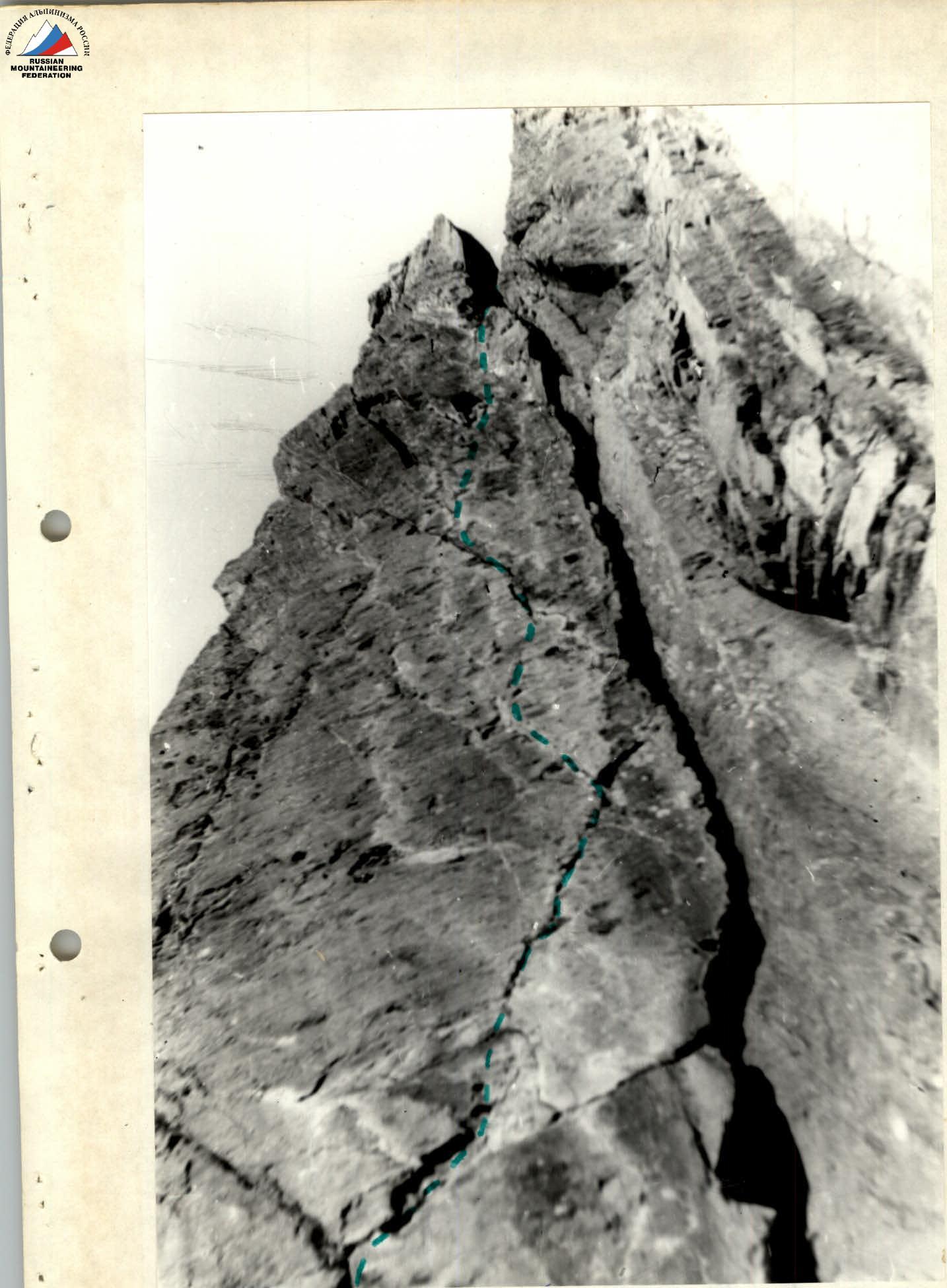
 Work of the Zhukov-Vikulin team on the R2–R3 section.
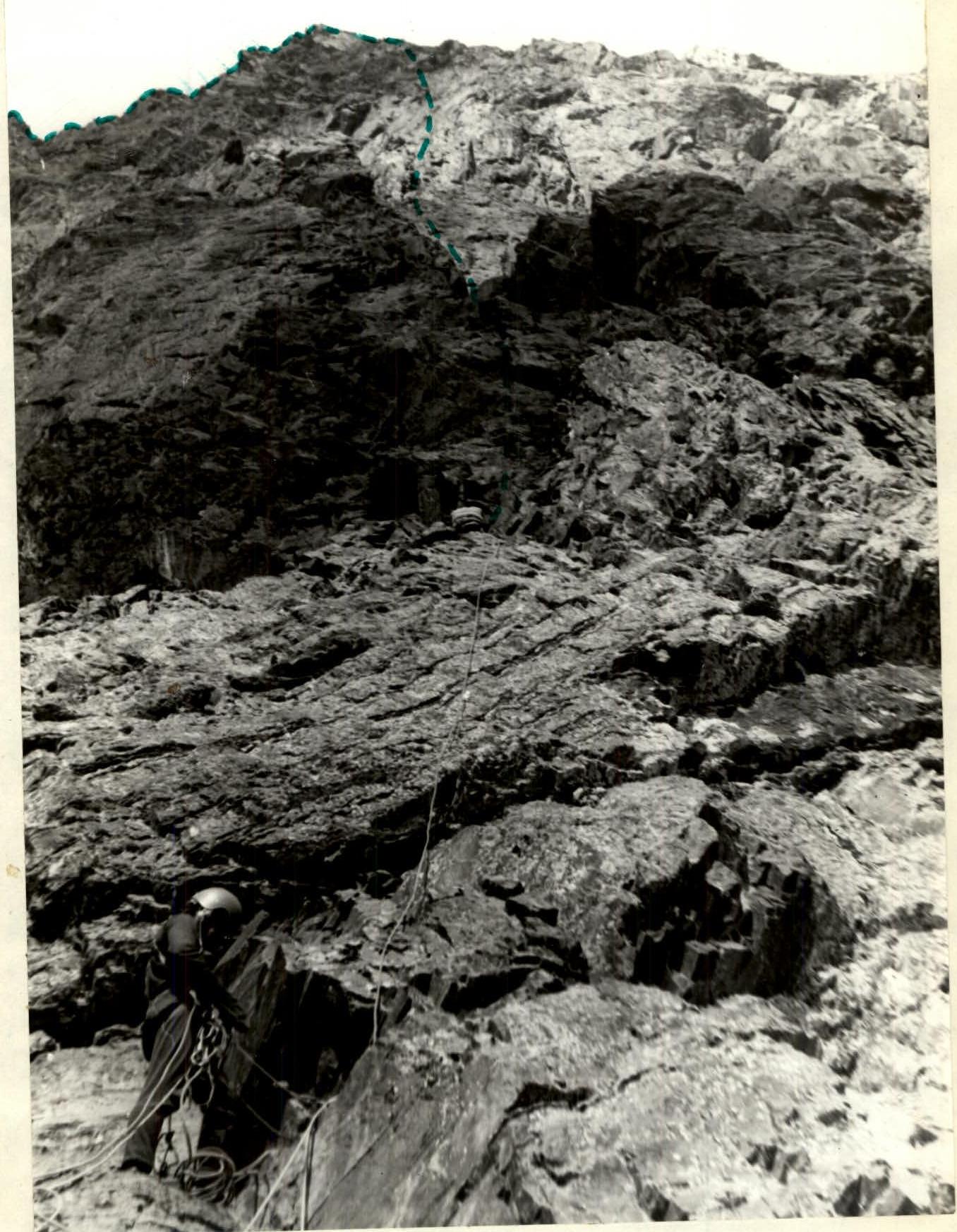
 Character of rocks on the route (R3–R4 section).
Zhukov A.B. Vikulin S.A. Mosivin B.V. Novogrudsky A.L. 12/III-80 g.