Ascent Passport
I. Technical Climbing Category.
2. Area 5.3. Zeravshan Range.
3. Peak Sakharnaya Golova (4971 m), via the right buttress of the North face.
4. 5-6 difficulty category.
5. Route characteristics: height difference — 970 m
average steepness — 65°, section lengths: I difficulty level — 120 m, II difficulty level — 40 m, III difficulty level — 200 m, IV difficulty level — 430 m, V-VI difficulty level — 465 m
6. Pitons driven: for belaying — rock: 71, ice: 16, chocks: 14; for creating artificial anchors — rock: 3.
7. Total climbing hours — 24.
8. Two bivouacs on the route on platforms without a tent.
9. Petrichenko Nikolai Nikolaevich — CMS
Orlov Oleg Leonidovich — CMS
10. Team coach: instructor Petrichenko N.N.
II. Date of departure for the route — July 19, 1979, and return from the route — July 21, 1979.
 (www.alpfederation.ru↗) 
(www.alpfederation.ru↗) 
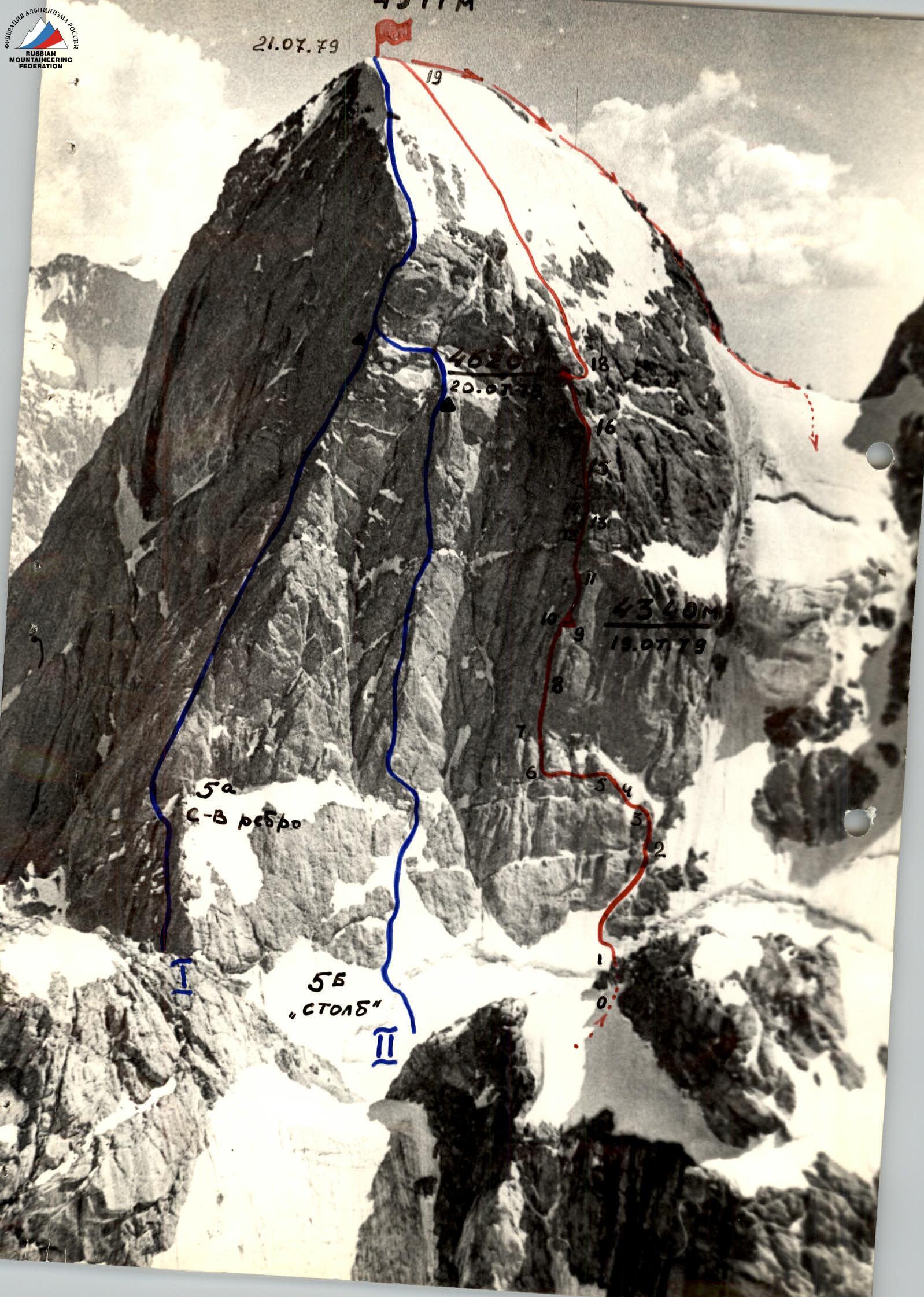
North face of Sakharnaya Golova (taken from the Akhbasay glacier plateau)
 (www.alpfederation.ru↗)
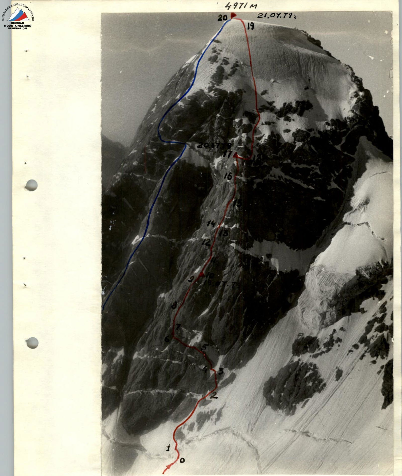
North foot of Sakharnaya Golova (taken from the foot of p. Moskva) Novoskuy group's route
Semi-profile of the North face (taken from the Akhbasay plateau under p. Blok) Peak Sakharnaya Golova (4971 m) is located in the Zeravshan Range in the upper reaches of the Akhbasay gorge. This part of the Zeravshan Range belongs to the high-altitude region known as the Fann Mountains.
Sakharnaya Golova is a very impressive peak, crowned with a large snow-ice cap, featuring sheer walls and pronounced ridges with a height difference of over 1 km.
Several interesting routes have been established on the peak, none of which are below 4-6 difficulty category.
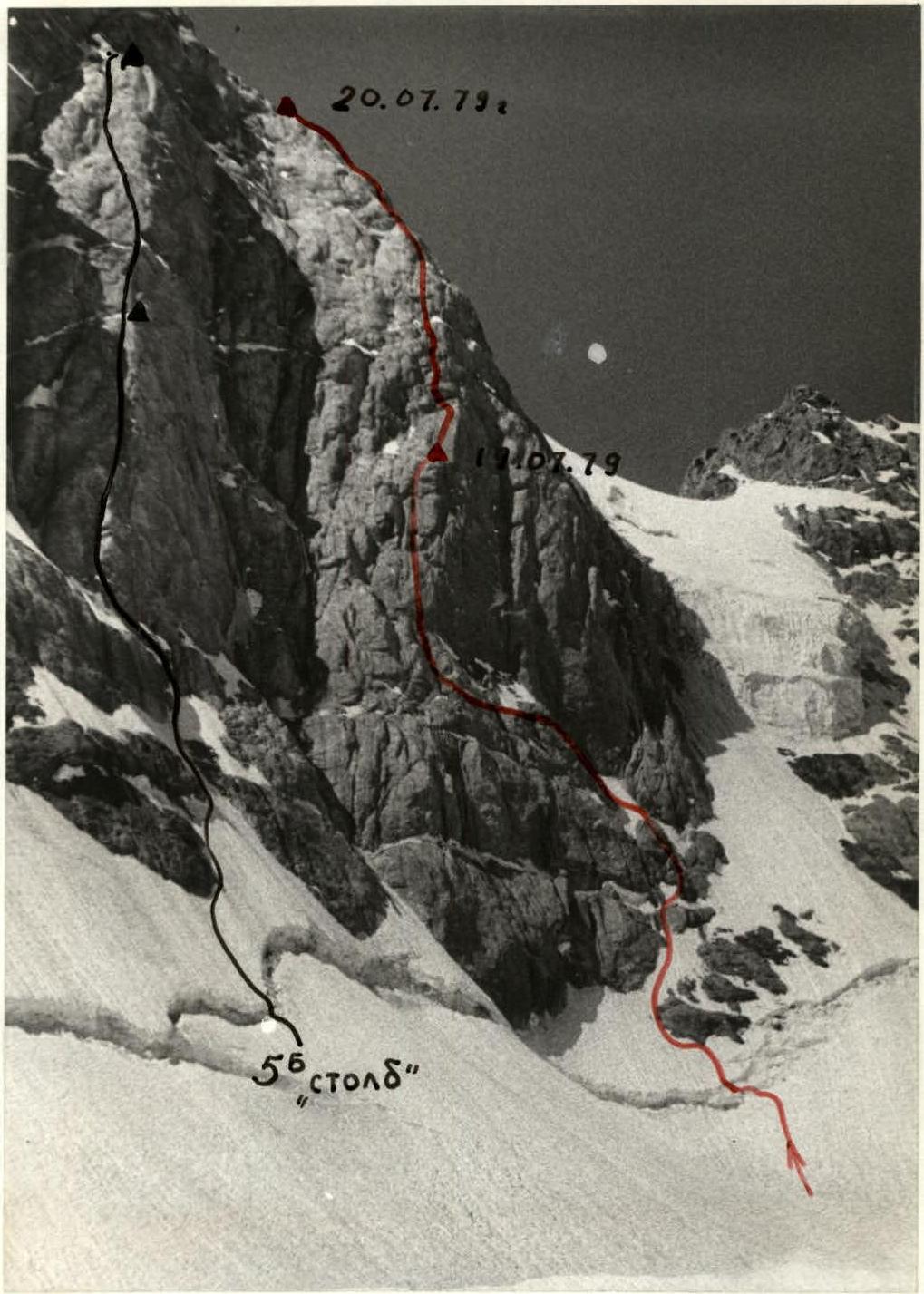
- The most challenging route, 5-6 category, passes through the "pillar" — a steep central buttress of the North face.
- Two 5A category routes are laid out along the East face and the North-East ridge.
- The traverse route of peaks Sakharnaya Golova-Moskva-Blok, 5-6 category, begins with the ascent along the North-East ridge.
While traversing, we noticed that the right buttress of the North face of Sakharnaya Golova is a logical path to the summit and is technically no less challenging than the 5-6 category route via the "pillar". The planned route was successfully completed and is presented in this report.
Approach to the Route Description
From the base camp, located on the bank of the Kaznok river (a common location for the Varzob alpine camp's branch) near the "Tepa" clearing, it is necessary to cross to the right bank of the Kaznok river and move along a good trail into the Akhbasay gorge. Before reaching the terminal moraine of the Akhbasay glacier, the trail turns right towards the Dvoynoy pass. After overcoming the first steep climb, it is advisable to leave the trail to the left and exit under the slopes of p. Blok onto the lateral moraine of the Akhbasay glacier. There are several well-equipped platforms for tents here.
From the base camp — 4-5 hours.
From the bivouac on the moraine, in 30-50 minutes, you can reach the foot of the routes on the North face of Sakharnaya Golova via a gentle, closed glacier.
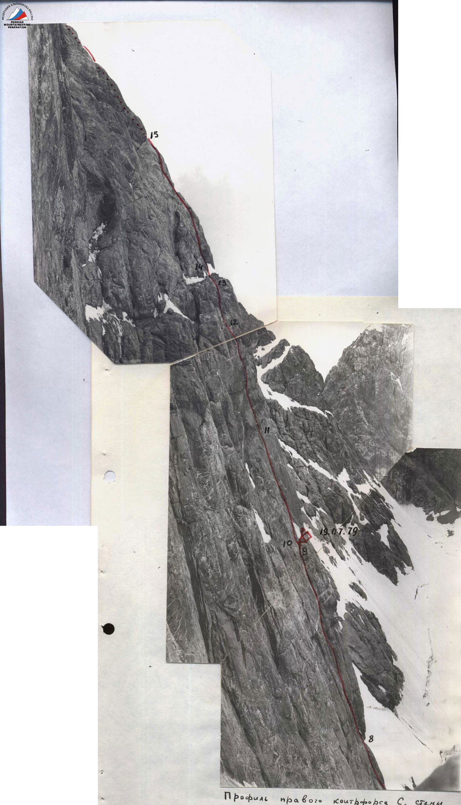
Profile of the right buttress of the North face (taken from the "pillar")
Explanations for the Route's Technical Characteristics Table
A good landmark for the start of the route is a large rock island at the base of the buttress wall. Crossing the bergschrund is conveniently done directly under the island, where the crevice is widened and filled with snow plugs, and the height of the snow wall does not exceed 2.5 m.
After the bergschrund, we go around the rock island from the left and move up to the right along a snow "necktie," bypassing the first rock belt of the buttress. On the right edge of the second rock belt, we reach a rock rib, which after 40 m leads to a large, steep snow patch lying on a wide, oblique ledge. We traverse the snow patch at the level of the upper part of the rib. Here, a thin layer of snow (up to 15 cm) lies on a 45-degree ice slope. We have to cut steps and use 2-3 ice screws for passage.
After the snow patch, we move up 40-50 m along the boundary between snow and rocks and begin to traverse a 55-degree rock slope to the left. The traverse along small ledges and gentle rocks is 80 m long; its left boundary is a deep, vertical inner corner, near which the most challenging wall section of the route begins.
The lower part of the route (sections R0-R6) can be rated 3B-4A category. It takes about 4 hours to complete.
Straightening the route by climbing directly through the two rock belts of the lower part of the buttress is impractical. The first rock belt is a monolithic "ram's forehead," which can only be passed with pitons. The second rock belt is also quite complex, with several inner corners featuring overhangs. The proposed variant here is a logical solution for the lower part of the route.
Having climbed 20-25 m up the inner corner, we reach the base of a 70-meter sheer wall with poorly defined micro-relief. The wall features predominantly "shell" holds — small but convenient for climbing in galoshes. However, due to the great steepness, climbing is very tense and draining. Moving with a backpack is almost impossible. Using ladders is ineffective due to the limited number of cracks. We have to climb free, stopping at each driven piton to carefully study the next section to the next piton.
The wall gradually transitions into two parallel inner corners. At first glance, the left corner seems slightly simpler, but for further progress, it proves to be less promising as it gets blocked by a massive rock overhang after 35 m. The right corner also has several overhanging sections but can be passed by free climbing.
From the corner, we exit through a small overhang onto a 10-meter wall and then via a chimney and cleft, and finally along gentler rocks onto a platform with a snow patch.
Here is the first platform on the wall for a tent. We set up a cairn. We process 40 m of the route and stop for a bivouac.
From the overnight stay, 12-15 m up the inner corner, and then 25 m to the right along a cleft to a ledge under a large, rusty overhang. The rusty overhang is bypassed from the left along a sheer wall (2-3 ladders are needed). Then, we have to make a counter-clockwise detour to avoid smoothed, overhanging "foreheads." There are many small traverses in this area, and there are no particular landmarks. Increased attentiveness is required when choosing the path to avoid missing the turn and losing the optimal route.
The rocks gradually become gentler and more fragmented. We reach a snow-covered terrace crossing almost the entire North face of the peak. The terrace offers convenient spots for overnight stays — a wide, scree-covered ledge, and snow is always present.
After the terrace, we can move along several roughly equivalent options:
- Move along the left edge
- Move along the center
- Move along the right edge
We need to aim to reach the ridge. There is a spall and a small platform that can serve as a landmark.
After the spall, we climb up a steep gully under an overhang, below which a cleft goes to the right. We bypass the overhang via the cleft and reach a 60-degree, slightly wet, and heavily smoothed slab.
The steepness begins to decrease, but the rocks become wet and brittle. Sometimes there are small sections of snow.
By this time, the weather has noticeably deteriorated. The peaks are shrouded in clouds, and a thick fog is creeping over the pass. Therefore, we decided not to rush the ascent and stop for a bivouac.
We organized the overnight stay on the left edge of a large, snow-covered ledge. Here, under an overhanging rock block, there is a closed niche where we can comfortably set up a bivouac.
In the first half of the third day, we overcame the snow-ice cap. Rock islands are unpromising for both progress and organizing belays due to their heavily destroyed structure and abundant icing on the rocks. The most rational path passes directly over the ice, where it is effective to use:
- crampons,
- ice screws.
There is a thin layer of snow on the ice, but in the morning hours, crampons hold well on it.
The descent from the summit of Sakharnaya Golova is done via the traditional path to the saddle and then around the peak Sakharnaya Golova or to the opposite side towards the pass.
The descent path follows a 4-6 category route, which is practically never used as an ascent.
Route Conclusion
The completed route is a rather rare example in the Fann Mountains of a combined ascent route featuring diverse rock, snow, and ice sections.
The technical difficulty of the route is mainly determined by the complex central part of the rock wall.
In terms of length, steepness, and technical density, the present route is similar to the nearby route via the "pillar" of 5-6 category. On the "pillar":
- the micro-relief is better defined;
- the holds are more convenient for climbing;
- pitons go in well (especially channel pitons).
On the right buttress:
- the micro-relief is well-defined in the form of inner corners, rock ridges, and large overhanging blocks;
- the rocks are more smoothed;
- small "shell" type holds prevail;
- smooth slabs are often encountered.
Having several ascents in the Fann Mountains in our record, such as:
- Arg via the N wall, 5-6 category
- Chimtarga via the 10-3 buttress, 5-6 category
- Zindon via the N wall, 6 category
- Sakharnaya Golova via the "pillar" of the N wall, 5-6 category
- Traverse Sakharnaya Golova-Moskva-Blok, 5-6 category
the group evaluates the route as 5-6 category difficulty.

Section 10-11. The first participant is at point 11. View towards section 11-12.
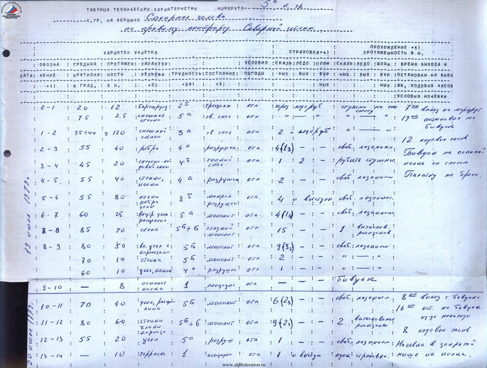
Technical Module's Table of the Route 5B Category to Peak Sakharnaya Golova via the Right Buttress of the North Face
Designation R0–R1: Average steepness: 20°; Length: 12 m; Terrain character: bergschrund; Difficulty: 2B; Condition: crevices; Weather: excellent; Belay conditions: via, ice screw; Passage: on snow steps; Time of departure and stop: 19:00, stop for bivouac. Designation R0–R1 (continued): Average steepness: 75°; Length: 2.5 m; Terrain character: snow wall; Difficulty: 5A; Condition: hard snow; Weather: excellent; Passage: on artificial anchors steps; Overnight conditions: bivouac. Designation R1–R2: Average steepness: 35-40°; Length: 120 m; Terrain character: snow slope; Difficulty: 3A; Condition: hard snow; Weather: excellent; Belay conditions: 2-3 ice screws; Passage: free climbing; Time of departure and stop: 12 climbing hours. Designation R2–R3: Average steepness: 55°; Length: 40 m; Terrain character: rib; Difficulty: 4A; Condition: destroyed; Weather: excellent; Belay conditions: 4 (1-3); Passage: free climbing; Overnight conditions: bivouac on a scree ledge with snow. Designation R3–R4: Average steepness: 45°; Length: 20 m; Terrain character: snow-ice slope; Difficulty: 4B; Condition: thin snow; Weather: excellent; Belay conditions: 2; Passage: cutting steps; Overnight conditions: no tent. Designation R4–R5: Average steepness: 55°; Length: 50 m; Terrain character: walls, ledges; Difficulty: 4A; Condition: destroyed; Weather: excellent; Belay conditions: 2; Passage: free climbing. Designation R5–R6: Average steepness: 55°; Length: 80 m; Terrain character: ledges, ribs, corners; Difficulty: 3B; Condition: wet, destroyed; Weather: excellent; Belay conditions: 4, ledges; Passage: free climbing. Designation R6–R7: Average steepness: 60°; Length: 25 m; Terrain character: inner corner, cleft; Difficulty: 5A; Condition: monolithic; Weather: excellent; Belay conditions: 4 (1-3); Passage: free climbing. Designation R7–R8: Average steepness: 85°; Length: 70 m; Terrain character: wall; Difficulty: 5-6; Condition: smooth, monolithic; Weather: excellent; Belay conditions: 15, 1; Passage: pulling up backpacks. Designation R8–R9: Average steepness: 80°; Length: 50 m; Terrain character: inner corner with overhangs; Difficulty: 5B; Condition: monolithic; Weather: excellent; Belay conditions: 9 (3-3); Passage: free climbing. Designation R8–R9 (continued): Average steepness: 70°; Length: 10 m; Terrain character: wall; Difficulty: 5-6; Condition: monolithic; Weather: excellent; Belay conditions: 2. Designation R8–R9 (continued): Average steepness: 60°; Length: 10 m; Terrain character: corner, chimney; Difficulty: 4; Condition: destroyed; Weather: excellent. Designation R9–R10: Average steepness: —; Length: 8 m; Terrain character: scree ledge; Difficulty: 1; Condition: platform; Weather: excellent; Overnight conditions: bivouac on July 20, 1979. Designation R10–R11: Average steepness: 70°; Length: 40 m; Terrain character: corner, cleft, slabs; Difficulty: 5B; Condition: monolithic; Weather: excellent; Belay conditions: 6 (2-3); Passage: free climbing; Time of departure and stop: 8:00, departure from bivouac; 16:00, stop for bivouac due to bad weather. Designation R11–R12: Average steepness: 80°; Length: 60 m; Terrain character: walls, blocks, overhangs; Difficulty: 5-6; Condition: monolithic; Weather: excellent; Belay conditions: 9 (2-3); Passage: 2, pulling up backpacks; Overnight conditions: 8 climbing hours. Designation R12–R13: Average steepness: 55°; Length: 20 m; Terrain character: corner; Difficulty: 5A; Condition: destroyed; Weather: excellent; Passage: free climbing; Overnight conditions: overnight stay in a closed niche on a ledge. Designation R13–R14: Average steepness: —; Length: 10 m; Terrain character: terrace; Difficulty: 1; Condition: platform; Weather: excellent; Belay conditions: 1, ledges; Passage: attached belay. Designation R14–R15: Average steepness: 70°; Length: 75 m; Terrain character: section, cleft, slabs; Difficulty: 5B; Condition: monolithic; Weather: cloudy; Belay conditions: 11 (3-3); Passage: free climbing. Designation R15–R16: Average steepness: 65°; Length: 80 m; Terrain character: cleft, slab; Difficulty: 5B-5A; Condition: wet, strong icing; Weather: cloudy; Belay conditions: 8 (1-3); Passage: free climbing. Designation R16–R17: Average steepness: 55°; Length: 60 m; Terrain character: slabs, blocks, flakes; Difficulty: 5A-5B; Condition: wet, strong destruction; Weather: fog; Belay conditions: 4 (1-3); Passage: free climbing. Designation R17–R18: Average steepness: 30°; Length: 30 m; Terrain character: ledge; Difficulty: 2B; Condition: snow patch; Weather: fog; Passage: —; Overnight conditions: bivouac. Designation R18–R19 (July 21, 1979): Average steepness: 40-55°; Length: 320 m; Terrain character: snow-ice slope; Difficulty: 4-5; Condition: hard snow, cold; Weather: fog; Belay conditions: 1, 14; Passage: crampons, sometimes cutting steps; Time of departure and stop: 8:00, departure from bivouac, 12:00, reaching the summit. Designation R19–R20: Average steepness: 10-25°; Length: 100 m; Terrain character: snow plateau; Difficulty: 1; Condition: hard snow; Weather: excellent; Belay conditions: simultaneous; Passage: simultaneous; Time of departure and stop: 4 climbing hours. Total: pitons driven: rock 85, ice 16, chocks 14 (pitons 0); total climbing hours: 24; two overnight stays.