Ascent Passport
- Ascent class — high-altitude technical
- Ascent area — Pamir-Alai, Zeravshan Range
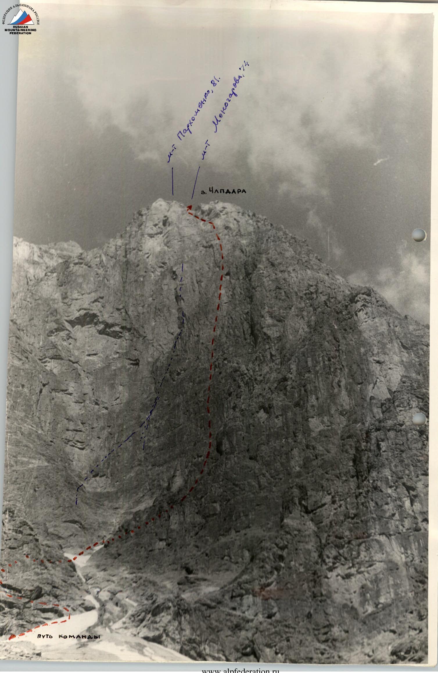
- Peak, its height, ascent route — Chapdara, 5297 m, via the Northeast wall.
- Expected difficulty category — 6B cat. diff., classified
- Route characteristics — wall, total route length (sections R0–R24) — 2200 m, length of sections I–VI cat. diff. — 920 m, wall height difference — 900 m, average steepness — 85–87°
- Pitons driven: for belaying, for creating ITDs: rock — 208 pcs., ice — 6 pcs., bolt — 12 pcs., chocks — 3 pcs.
- Number of climbing hours — 42 hours
- Number of bivouacs and their characteristics — three bivouacs: first — lying in a niche, all together; second — on a narrow ledge, three + one; third — on the ridge, platform, all together.
- Surname, name, patronymic of the leader, participants, their qualification:
- Vakhmenin Anatoly Sergeevich — leader, CMS
- Ivashchenko Alexey Sergeevich — participant, CMS
- Retyunsky Yuri Dmitrievich — participant, CMS
- Shchukin Vladimir Ivanovich — participant, CMS
- Team coach — Shchukin V. I.
- Date of departure and return — July 26 – July 29, 1980

Brief Explanation for the Table
To the start of the route from the observers' bivouac along the ledges of the rocky island to the right-up towards the couloir. Then through the couloir and along the slippery slope to the lower part of the dried-up waterfall. From the waterfall along a series of ledges (80 m, 20°) to the right to the destroyed rocks. Along the destroyed rocks (50 m, 40°) up to a horizontal wide ledge, along the ledge 40 m to the left to the internal angle. Along the internal angle (80 m, 70°) approach under the wall.
Along the wall vertically up under the "Г"-shaped cornice. The cornice and wall are bypassed on the left — exit to a small ledge under the cornice (80 m, 85–90°). Control tour No. 1 in a blue canister under the cornice. From the control tour along the vertical wall to the left (30 m, 90°) to a narrow inclined ledge. To the left along the ledge in a niche — bivouac.
From the bivouac to the right along the ledge, then along the monolithic wall (90 m, 87°) vertically up to the destroyed rocks. Further along the destroyed walls to the left (85 m, 70°) under the base of a large faceted internal angle.
Along the internal angle up (35 m, 76°), then to the right (20 m, 82°) along the monolithic wall — exit to a narrow ledge. Bivouac. From the bivouac to the right along the ledge and up to the right (40 m, 80°) along the monolithic wall — approach to the key section of the route — a hundred-meter overhanging wall. In the center of the wall — control tour No. 2. Along the wall vertically up (100 m, 92–95°) to a vaguely expressed internal angle, further along the angle (80 m, 88–90°) to the base of a monolithic smooth slab with a narrow crack. Along the wall up-left (120 m, 80–85°) to the internal angle and along the internal angle up (80 m, 75°) — exit to the counterfort, control tour No. 3 in a blue canister.
Further along the inclined slabs, alternating with small walls, to the left-up (80 m, 60°), then along the wall (25 m, 80°) to the internal angle. Along the angle up (30 m, 85°) to a horizontal ledge and along the ledge to the right — exit to the platform. Bivouac. Control tour No. 4 in a blue canister.
From the platform up along the wall (3 m, 80°) — exit to the ridge. Then along the snowy slope (300 m, 20°) — approach under the "gendarme" wall. Along the "gendarme" wall vertically up (60 m, 80°) and further along the destroyed ridge (300 m, 20°) — to the snow-ice rise. First along the snow (150 m), and then along the ice (50 m) — exit to the scree ridge. Along the ridge (40 m, 5°) — approach under the wall (8 m, 50°). Along it — exit to the destroyed scree ridge and along it (150 m, 10°) — exit to the summit.
Descent from the summit along the southwestern slopes towards Peak Zamok and further along the trail to the base camp on Lake Bibi-Djanat.
As a result of observations, it was established that the NE wall "TIKHAYA" — no rockfalls were observed on it. Conditions for ascent are good. Crossing the couloir in front of the wall must be done before 6:00–6:30. After 7:00, rockfalls often occur along the couloir. There is no water on the wall. The waterfall in the right lower part of the wall dries up at 11:00–12:00. Based on the observations, the tactical plan for the ascent was adjusted, and it was decided that the group was ready for the ascent.
On July 26, 1980, the group started the route.
Route Passage
July 25. Ivashchenko and Retyunsky left the observers' bivouac in the morning to study the wall more closely (and from a closer distance), the start of the route, the path to the wall, and find a bivouac on the island as close as possible to the couloir that needs to be crossed when approaching the wall. It became clear yesterday during the preliminary study of the couloir through a spyglass that we wouldn't be able to process the route. Communication with the duo every hour via "Vitalka". After lunch, the duo returned. Conclusion: the couloir was crossed before 7:00; a bivouac on the island (in a niche) was set up. The group went to the island for the night.
July 26. Rise at 5:00. Departure at 6:00. Along the ledges of the rocky island to the right — up towards the couloir. Movement is simultaneous, belay from protrusions. About 140–160 m to the couloir. Crossing the couloir — movement is alternating. Further to the right, towards the dried-up waterfall, along an almost horizontal ledge 60–80 m. Then the path along the rocks of medium complexity (section R0–R4). Relief: rocky ledges and internal angles. Length — 3 ropes. Approached the wall. Clearly visible canister is 2–3 ropes above us. On a narrow ledge under the wall, we had breakfast. Filled up water flasks. After breakfast, we started the ascent.
On this day, Ivashchenko worked first. Distributed the load among the three — the first one works without a backpack. The first rope along the wall, climbing is complex. Up-left, bypassing the "Г"-shaped cornice. After bypassing the cornice — straight up to a narrow ledge under the canister. At the end of the second rope, it becomes steeper. The canister is hung on a bolt piton under the cornice. To the right — an overhanging wall. To the left — a quite logical path. Climbing to the canister is very complex. The bolts that were used to approach it are cut down. Ivashchenko continued further, and Shchukin climbed to the canister — changed the note. Another two ropes along the wall and internal angles. The wall is steep. Approached a narrow ledge passing almost through the entire wall. Found a good niche on the ledge a rope to the left, which was quickly turned into a comfortable bivouac. Mainly — protected from stones. True, we hadn't heard any stones yet. The wall is "quiet". Until 14:00 it's hot, water is scarce. Thirst is quenched by rhubarb, which grows abundantly on the slopes. We stopped for the night early. Tried to process the path. Very complex. Found only the easiest path. Didn't have time to process it.
July 27. Rise at 6:00. Departure at 7:30. Path straight up from the exit to the ledge (i.e., 30–40 m to the right of the bivouac). The wall is steep. We meet pitons from previous groups. More than 4 ropes along a monolithic wall with small holds. Shchukin works first. Another rope along the internal angle led to a ledge with destroyed relief. Along the relief (4 cat. diff.) to the left and slightly up (20–40°) — about three ropes to a steep internal angle. Here the NE wall converges with the North wall of the "well". Further along the angle up 30–35 m and exit to a narrow ledge under a large internal angle with a cornice. On the ledge — bivouac. Three lay together, at an angle to the wall — the ledge is narrow. One spent the night 10 m away; the ledge's width allowed lying along the wall. From the bivouac to the right-up along the right side of the angle — transition to a steep monolithic wall.
On the wall — a "bolt road". Half of the bolts are cut down. On this day, we hung two ropes.
July 28. Rise at 6:00. Departure at 7:30. Two processed ropes led to the middle of the wall. Further — straight up. Climbing is complex. One rope slightly to the right. In front of us is a steep wall with a system of internal angles. The path is the same everywhere. Steep. Small holds, monolithic rocks. Another five ropes of approximately the same "sixth category" climbing, and we exited to the counterfort. In the angle, at the junction of the counterfort and the North ridge — a good stream. Now there's enough water. Shchukin worked ahead on this day. Along the counterfort, two ropes of medium climbing along rocky walls 60°. Then along the angle vertically up 15 m, and exited to a wet ledge. Along the ledge, traverse to the right 8–10 m, exited to platforms. Good bivouac. A lot of equipment: (from Monogarov's group), fixed ropes, bolts, another canister. This day was the longest. Exited to the platform at 20:30. Bivouac is comfortable. Three meters up — exit to the ridge. The wall ended.
July 29. Rise at 7:00. Departure at 8:00. Along the angle exited to the ridge. Snow. Along the snowy ridge about 300 m, steepness 15–20° — approached a "gendarme" in the ridge. Along the wall (4 cat. diff.) of the "gendarme" about 60 m — exit to the rocky ridge. Along the rocky destroyed ridge — simultaneously, belay through protrusions. Ridge length is about 300 m. The ridge led to a snow-ice slope at first, then steeper up to 50–55°. Slope length is about 200 m. Along the snow-ice slope exited to a cirque. From the cirque to the summit along the ridge — about 25 minutes. At 14:00, we were on the summit of Chapdara.
Descent from the summit along the known path to the Northwest towards Peak Zamok. On the trail by 17:00.
On the same day, the group was at Lake Aladdin. And the next day, through Pass Alaudin, returned to the base camp on Lake Bibi-Djanat.
The group passed the route mainly according to the preliminary plan. A small change — refusal to process — was made due to safety considerations. Ahead, on the wall, worked two: Shchukin V. and Ivashchenko A. On chiselling — Retyunsky Yu. and Ivashchenko A. The group climbed the entire complex wall from double ropes. By maximally lightening the group without compromising safety, the group did not use pulling up backpacks. The group applied an accelerated tactic for passing the wall. This was done to pass the wall as quickly as possible since the water supply was limited. The tactic's essence was that the first one, after accepting the second, immediately went up. The third moved along two fixed ropes: on one rope were both jammers (chest–leg), on the other — belay using a clove hitch. The second and third participants moved along the fixed ropes with top-rope belay. This increased pace was within the group's capabilities, having good physical and rock climbing training.
The route along the NE wall is the third ascent of Monogarov's route. This is undoubtedly a route of 6B cat. diff. Vertical wall without water. Climbing is very complex, but the rocks have good holds. Among the routes of the 6th category climbed by participants in this area (Zindon, Bodkhona via Golchin, Chapdara via Solonnikov), the length of the complex section on this wall is the longest. The saturation with complexity is the highest.
The route is safe, interesting, and undeservedly forgotten. True, after us, another camp group passed this route. We hope that this route will start to be climbed. Approaches to the wall are not further than approaches to Bodkhona, a "six" that is climbed more often. A safe, vertical, warm wall should bring pleasure to fans of wall climbing.
All participants coped with the tasks set before the ascent. Pre-season training, production of lightweight equipment (carabiners, pitons, sleeping bags, backpacks) allowed the group to pass the wall in an optimal mode with a good margin of safety.
In our opinion, the tactics and schedule for passing the wall by the group are optimal. It's hard to recommend anything to other groups to improve the quality of the ascent. The only thing is that it's necessary to take more water, although we managed with 3.5 l. The optimal group composition is 5 people.
TABLE BASIC CHARACTERISTICS OF THE ASCENT ROUTE
| Date | Section | Steepness | Length | Relief | Cat. diff. | Weather | Conditions | Rock | Ice | Bolt | Chocks |
|---|---|---|---|---|---|---|---|---|---|---|---|
| 25.07.1980 | R0–R1 | 20° | 80 m | Ledges | 1 | Destroyed | Clear, simultaneous, protrusions | 1 | 5 | 0 | 1 |
| R1–R2 | 40° | 50 m | Slope | 1 | Destroyed | Clear, simultaneous, protrusions | 1 | 1 | 0 | 1 | |
| R2–R3 | 35° | 40 m | Slab | 1 | Monolithic | Clear, simultaneous, protrusions | 1 | 1 | 0 | 1 | |
| R3–R4 | 70° | 20 m | Internal angle | 1 | Monolithic | Clear | 1 | 5 | 0 | ||
| Departure from bivouac at 6:00. Stop for lunch before the wall — 9:00. Height of the wall's base / start. | |||||||||||
| R4–R5 | 85–90° | 140 m | Wall | 1–6 | Monolithic | 125/11 | 1 | 0 | 1 | ||
| Stop for the night at 18:30. Number of climbing hours – 10 hours 30 minutes. Bivouac in a niche, lying on four. Height of bivouac. On section R4–R5 control tour No. 1 in a blue canister. | |||||||||||
| 27.07.1980 | R5–R6 | 85–87° | 90 m | Wall | 6 | Monolithic | Clear | 18/111 | 1 | 0 | 3 |
| R5–R7 | 70° | 85 m | Wall | 5–6 | Destroyed | 13 | 1 | 0 | 0 | ||
| R7–R8 | 75–77° | 35 m | Internal angle | 5–6 | Monolithic | 8 | 1 | 0 | 0 | ||
| R8–R9 | 80–82° | 20 m | Wall | 5 | Monolithic | 3 | 0 | 2 | 0 | ||
| Departure from bivouac at 7:30. Stop for the night at 18:00. Height of bivouac – Processing 2 hours. Number of climbing hours (with processing) – 12 hours 50 minutes. Bivouac on a narrow ledge under an overhanging wall, bivouac lying, separate, three and one. | |||||||||||
| 28.07.1980 | R9–R10 | 80° | 40 m | Wall | 5 | Monolithic | Clear | 5 | 1 | 0 | 2 |
| R10–R11 | 92–95° | 95–100 m | Wall | 6 | Monolithic | Clear | 23/6 | 1 | 0 | 4 | |
| R11–R12 | 87–90° | 80 m | Internal angle | 6 | Monolithic | Clear | 22 | 1 | 0 | 2 | |
| R12–R13 | 80–85° | 120 m | Wall | 5–6 | Monolithic | 29/111 | 8 | 1 | 4 | ||
| R13–R14 | 70–75° | 80 m | Internal angle | 5 | Monolithic | 12 | 1 | 0 | 0 | ||
| R14–R15 | 50° | 80 m | Counterfort slope | 3 | Monolithic | 4 | 0 | 0 | 1 | ||
| R15–R16 | 80° | 25 m | Wall | 1 | Monolithic | 3 | 1 | 0 | 1 | ||
| R15–R17 | 82–85° | 30 m | Internal angle | 1 | Monolithic | ||||||
| Departure from bivouac at 7:30. Stop for the night at 20:30. Height of bivouac – Number of climbing hours – 13. Bivouac on a platform before exiting to the ridge. Bivouac lying, together. On sections R10–R11, R13–R14 and at the bivouac control tours in a polyethylene flask and a blue canister. | |||||||||||
| 29.07.1980 | R17–R18 | 20° | 300 m | Ridge | 1 | Clear, simultaneous | |||||
| R18–R19 | 80° | 60 m | "Gendarme" wall | 4–5 | Monolithic | Clear, simultaneous, protrusions | |||||
| R19–R20 | 20° | 300 m | Rocky ridge | 2 | Destroyed | Clear, simultaneous, protrusions | |||||
| R20–R21 | 50° | 200 m | Slope | 5 | Snow, ice | 5 | 1 | 1 | |||
| R21–R22 | 5–10° | 40 m | Ridge | 1 | Clear, simultaneous | ||||||
| R22–R23 | 40–50° | 8 m | Wall | 1 | Destroyed | Simultaneous | |||||
| R23–R24 | 10–15° | 150 m | Ridge | 1 | Destroyed | Simultaneous | |||||
| Departure from bivouac at 8:00. Exit to the summit at 14:00. Control tour on the summit. Number of climbing hours – 5. Descent from the summit to the Northwest towards Peak Zamok. Climbing hours on descent to the trail – 3. Return to the intermediate camp on Lake Alaudin at 19:30. | |||||||||||
| Total: wall – 925 m, climbing hours – 42. |