122
All-Union Central Council of Trade Unions
Central Council of the Spartak Volunteer Sports Society
Report
On the ascent to the summit of Chapdara via the North face
of the team from the Ukrainian Council of the Spartak Volunteer Sports Society
August 1–7, 1970
Kustovskiy A. A. Cherevko V. A. Shilo O. A. Yakovina V. A.
Kiev
1970
-
Class of ascent — technically challenging.
-
Region of ascent — Fann Mountains.
-
Route of ascent — Chapdara peak via the North face, 5197 m.
-
Characteristics of the ascent — altitude difference 2100 m.
Average steepness 75–80°. Length of difficult sections 1400 m.
-
Number of pitons:
- rock 179
- ice 5
- bolted 1
-
Number of travel hours — 65.5 hours.
-
Number of nights and their characteristics — total 5, in a tent, 1 bivouac in separate positions.
-
Team name — team of the Central Council of the Spartak Volunteer Sports Society, Ukrainian Council.
-
Full names of participants and their sports qualification:
- Kustovskiy Anatoliy Alekseyevich, Master of Sports
- Cherevko Vladimir Leonidovich, Master of Sports
- Yakovina Viktor Antonovich, Master of Sports
- Shilo Oleg Leonidovich, Candidate for Master of Sports
-
Date of ascent — August 7, 1970.
-
Place achieved by the team — fourth-fifth.
4008 m via the NE ridge (Kustovskiy A. F.)
Description of the Ascent
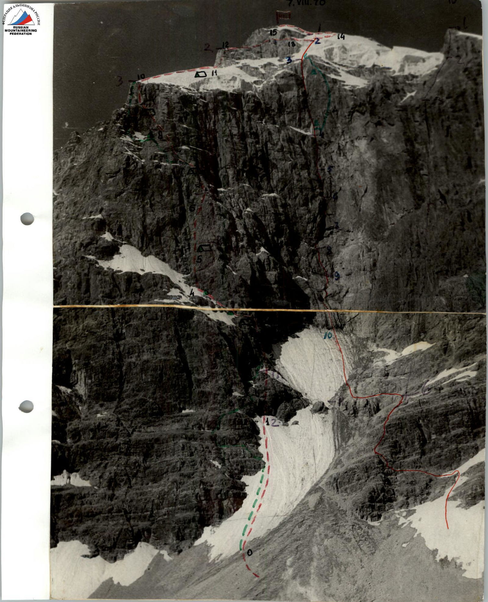
August 1. The route begins from the Chapdara glacier, with scree slopes and then a snowy slope, overhung by two hanging glaciers from the snowy cap of the peak. The height of the start of the route is about 3000 m. We continue observations of the wall, the nature of rockfall and ice avalanches, which frequently sweep the center of the North face, started in previous days. At the same time, the pair — V. Cherevko and O. Shilo — goes out to process the lower part of the route.
Overcoming the R0–R1 section does not cause particular difficulties. At point R1, we have to move onto the rocks to reduce the danger of rockfall, which accumulates in the rocky "neck".
Having fixed ropes on the R0–R1 and R1–R2 sections, the pair returns to the observation group's camp, located on a grassy slope 200–300 m below the Talbas pass.
August 2, 1953. The weather is unstable, as it has been for the past few days. We decide to trust the encouraging forecast we received via radio and set out on the route at 6:00.
Having passed the section processed the previous day, R0–R2, we approach a rocky gully filled with regelation ice.
In the group, two pairs have crampons — for the first and last, who do the main work. The others walk on steps, pulling themselves up with clamps if necessary.
The ice is very steep, and stones occasionally fly from above. However, they posed a danger only on the R1–R2 section. Now we are protected by the wall.
At 16:00, we pass the gully (R2–R3 section) as a group.
The weather deteriorates completely:
- thunderstorm,
- dense snowfall.
We build a relatively flat platform, climb into the tent, and hope for the next day.
August 3, 1953. Cloudy. However, there is no snowfall. We set out on the route at 7:00. We move along the edge of ice and rocks with protection via pitons driven into the rocks (R3–R4 section).
The route is relatively straightforward; the weather is the main concern. Ahead of us lie complex rocky sections, which will be practically impossible to pass in wet weather.
In the afternoon, rain and wet snow start again. Still, we manage to pass three rope lengths of broken rocks (R4–R5 section). The gaps are small, and there are few of them. Nevertheless, traversing this section in rubber footwear (rock shoes, galoshes) brings back pleasant memories of Crimean routes. Challenging but reliable climbing. We again manage to build a sufficiently large platform for the night, where we pitch the tent.
August 4. Adapting to the weather, which usually worsens in the second half of the day, we set out early. Ahead lies a wall (R5–R6 section). The first climber goes without a backpack. However, our main concern is the movement of the entire group, not just the first. So, we use:
- ladders,
- blocks to pull up backpacks,
- additional rope.
For four people, we have three 50-meter ropes and a 50-meter Repschnur. All this shortens the time taken to traverse the route. The wall becomes steeper (R6–R7 section), and we use platforms. However, this is the first and last time. Later, having adapted to the rocks, we traverse all complex sections and even overhangs by climbing in galoshes. With enviable consistency, the weather starts to worsen. By around 20:00, we reach a small ledge and settle in for the night.
This was the only bivouac where we could not gather together and had to bivouac in separate positions.
August 5. We gather quickly. We move along the slabs to a not very distinct ridge, alternating with rocky walls (R7–R8 section).
The general direction of the ridge is towards the left edge of the overhanging glacier. Very challenging free climbing, with wedges and ladders in use. Fragments of ice start to fly from above. So far, they pass to our right, but, unfortunately, our direction of movement leads us to areas that are intensively "swept". We have to deviate left onto complex walls (R8–R9 section).
The weather "clouds over" again by the end of the day, but it doesn't come to snow. We find a small rocky balcony with snow, where we can arrange a decent night's stay.
One pair cuts a platform, while the other hangs a rope under the overhanging wall, which, according to our calculations, will lead us to the top of the wall.
August 6, 1953. From the last driven piton, the choice of route is unambiguous: before us lies a wall with a minimal number of holds, which is also overhanging. Climbing is extremely challenging and mainly relies on friction. Fortunately, the weather seems to have settled, the rocks are dry, and the friction is excellent (R9–R10 section).
The wall leads to a cornice. From under the cornice, a diagonal crack leads upwards, into which we can barely fit.
The crack is overhanging; we have to wedge ourselves in strongly, and movement is very slow. Finally, we are on the wall! It's an excellent place for protection and pulling up backpacks.
Upwards, a not very steep snow-ice slope leads to a snowy ridge. The snow holds well; we only need to cut steps in a few places (R10–R11 section).
We quickly gain height and reach the beginning of the rocky ridge.
The weather, which has treated us kindly in the morning, starts to worsen. Snowfall begins — first sparse, then a solid blanket. There's no clear exit to the rocky ridge. We have to traverse another wall with 20 meters of challenging climbing. The snowfall intensifies; visibility is zero. We pitch the tent and settle in for the night. We had hoped to reach the summit this day, so the delay is somewhat discouraging.
However, the excellent platform on the cut snow ridge makes up for it. We can stretch out to our full height and turn without risking hanging from the protection.
August 7. It has frozen overnight. We start to exit onto the ridge via the wall (R11–R12 section). The wall is challenging; we have to hang ladders. Finally, it's behind us.
The ridge is sharp, heavily destroyed; we move slowly in pairs with alternate protection (R12–R13 section). Finally, the ridge is behind us. We exit onto the pre-summit snow-ice fields.
Another 4 hours of trudging and cutting steps — and we are on the summit (R13–R14 and R14–R15 sections).
We immediately begin our descent via the normal route and return to the base camp in the evening, in twilight.

Chandara via the N face.