PASSPORT
I Technical Class
2 Pamir-Alay, Zeravshan Range, Alaudin Valley. 3 Chapdara peak (5053 m) via NW wall
4 First ascent, category 6 difficulty (tentative), combined
5 Height difference — 1650 m, length — 2230 m. Length of sections with 5–6 category difficulty — 1055 m, including 6 category — 465 m. Average route steepness — 71°. Average steepness of the wall section — 77° (3400–4775 m).
6 Pitons driven:
| Rock | Nuts | Bolts | Ice | |
|---|---|---|---|---|
| Climbed | 152 | 174 | 4 | 18 |
| Left | 47 | 68 | 3 | 0 |
7 Total climbing hours — 375 h and days — 8
8 Number of bivouacs:
- R1–R3, R6 — semi-reclining
- R4, R7 — reclining
- R5 — sitting
9 Team leader — Viktor P. Merlis, Master of Sports
Team members:
- Viktor V. Yumarov, Candidate for Master of Sports
- Mikhail V. Lebedev, Candidate for Master of Sports
- Konstantin A. Sakharov, Candidate for Master of Sports
- Alexander A. Tel’pov, Candidate for Master of Sports
10 Coach — Anatoly F. Vinokurov, Master of Sports
11 Departure date — July 13, 1989 Summit — July 20, 1989 Return — July 20, 1989
12 Moscow Regional Sports Committee
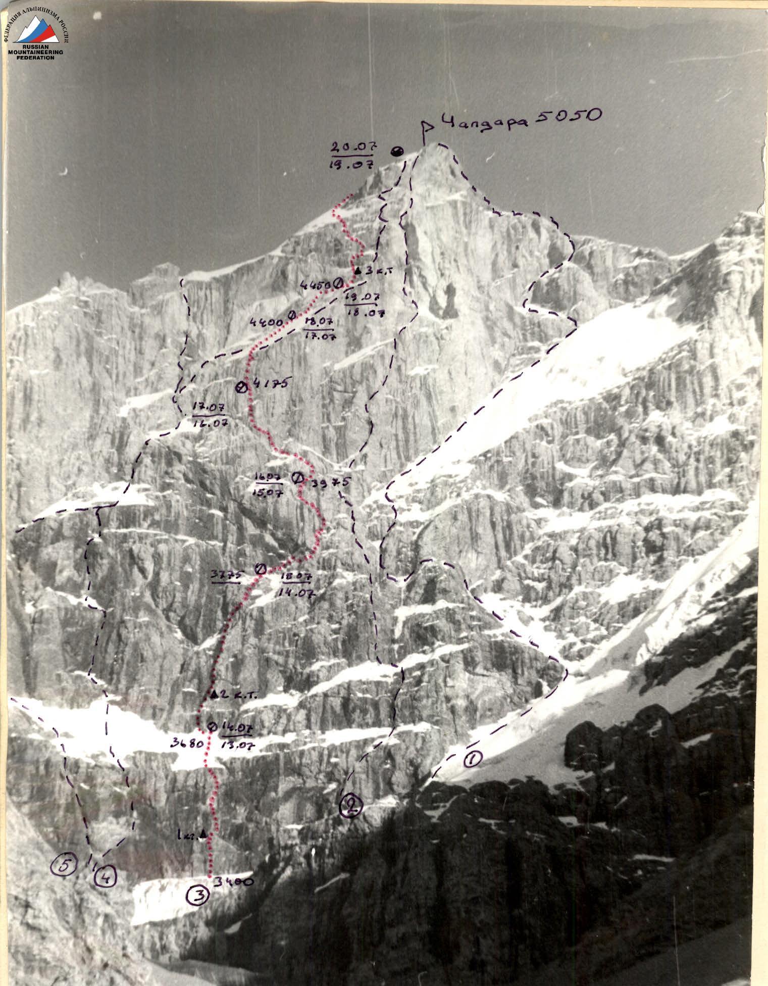
Photo 1. General photo of the summit. Taken on July 21, 1989, at 18:00. Approximate distance to the object — 3 km. Shooting point (f1), elevation — 3100 m.
Routes:
- 1 Kiselev L.'s route via NW wall (right route)
- 2 Solonnikov V.'s route via NW wall (left route)
- 3 Moscow Regional Sports Committee team's route
- 5 Melnikov V.'s route via NW ridge
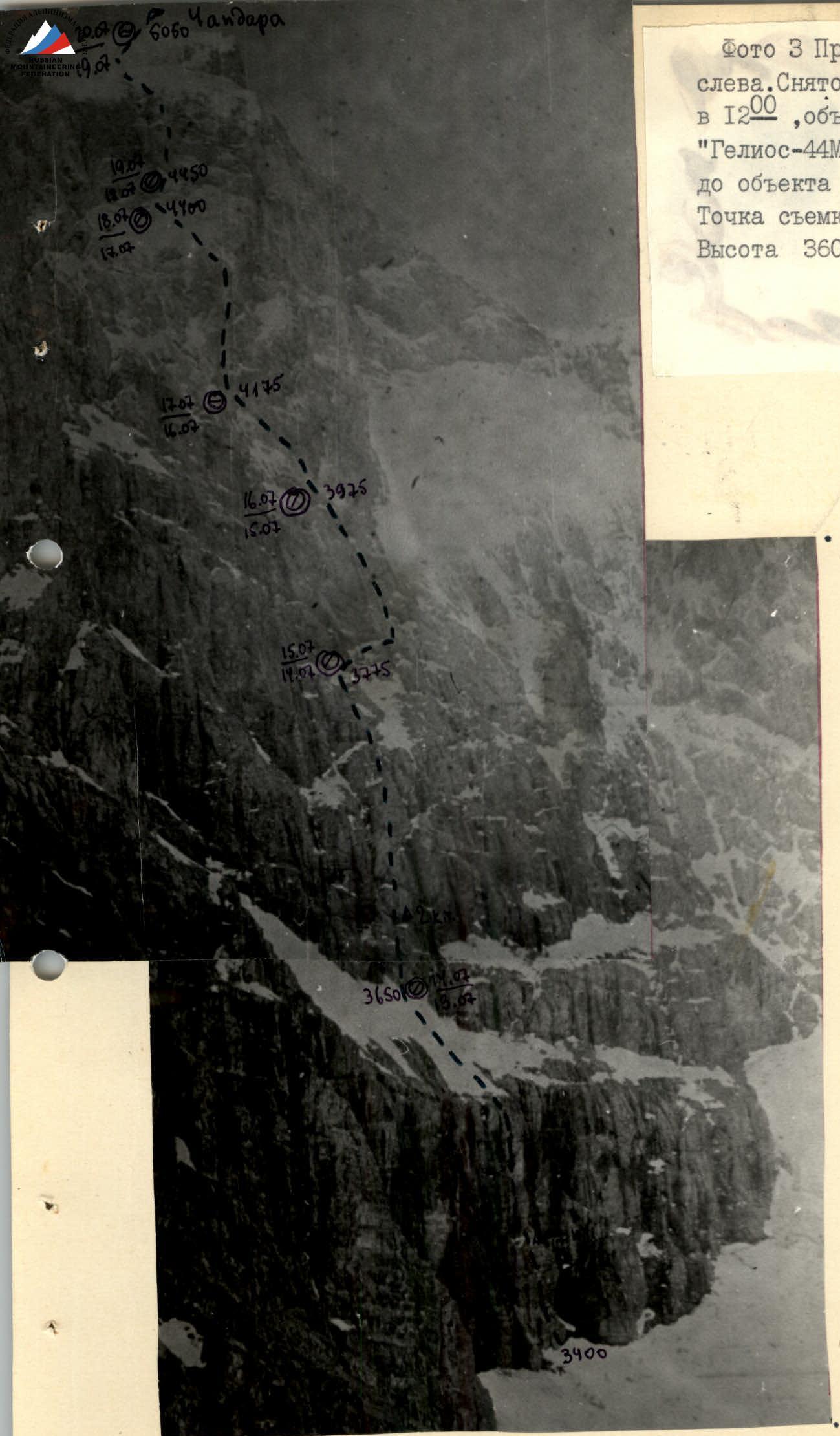
Photo 3. Profile of the left wall. Taken on July 15, 1989, at 12:00, lens "Helios-44M". Distance to the object — 1 km. Shooting point (f3). Elevation — 3600 m.
Unusually severe weather for the Fann Mountains began on the second day of the ascent and continued until the end. This threw the team off the schedule outlined in the tactical plan. Snowfall was almost continuous. Nevertheless, the ascent was completed.
Due to unstable weather that season, the team brought an increased set of equipment for artificial climbing and protection, warm clothing, extra food, and fuel, although it was clear and sunny when they started. Movement was organized with a change of lead and relatively even loading of participants.
The first to work were:
- on sections R0–R6, R12–R18, R30–R38, R39 — Komarov V.V.
- on sections R6–R12, R25–R26 — Tel’pov
- on sections R19–R25 — Merlis V.P.
- on sections R18–R19, R26–R31 — Lebedev M.V.
On July 18, due to the technical difficulty of the route and very bad weather, the group stopped moving and started organizing a bivouac already at 11:00, and the Lebedev–Komarov rope team processed section R30–R31, taking turns. They used skyhooks for climbing and bolt hangers for protection. Small avalanches greatly hindered their work.
The entire route (R0–R39) was climbed with fixed ropes, and movement on the ropes was done with top-rope protection. The first climber worked on a double rope (one of the ropes was UIAA).
Bivouac sites were chosen under overhanging rocks and cornices because the route was exposed to rockfall on sections R0–R30 and snow avalanches on sections R26–R38. In the lower part of the route, platforms were widened by shaping snow.
Hot meals were provided twice a day (morning and evening), and individual snacks were available during the day: raisins, dried apricots, nuts, chocolate, and a sports recovery drink called "Olympia".
Communication was not ideal, especially after the first few days when they had to operate the radio under running water. Nevertheless, the group was able to transmit information regularly and received guidance from the coach on route adjustments.
Route diagram in UIAA symbols Scale 1:2000
| Section | Rock | Nuts | Bolts | Ice | Difficulty | Length (m) | Steepness (°) |
|---|---|---|---|---|---|---|---|
| R0–R1 | 1 | 2 | – | – | 4 | 45 | 80 |
| R1–R2 | 1 | 3 | – | – | 5 | 20 | 90 |
| R2–R3 | 5 | 10 | – | – | 5 | 75 | 80 |
| R3–R4 | 1 | 2 | – | – | 6 | 30 | 90 |
| R4–R5 | 5 | – | – | – | 6 | 25 | 100 |
| R5–R6 | 6 | 12 | 1 | – | 6 | 20 | 100 |
| R6–R7 | 1 | 2 | – | – | 4 | 20 | 80 |
| R7–R8 | 5 | – | – | 3 | 3 | 100 | 55 |
| R8–R9 | 4 | 3 | – | – | 6 | 65 | 70 |
| R9–R10 | 2 | 6 | – | – | 6 | 35 | 95 |
| R10–R11 | 10 | 3 | – | – | 5 | 120 | 66 |
| R11–R12 | – | – | – | – | 3 | 50 | 80 |
| R12–R13 | – | – | – | – | 4 | 45 | 70 |
| R13–R14 | – | – | – | – | 6 | 40 | 88 |
| R14–R15 | – | – | – | – | 5 | 10 | 80 |
| R15–R16 | – | – | – | – | 6 | 30 | 85 |
| R16–R17 | 5 | 8 | – | – | 5 | 80 | 75 |
| R17–R18 | 8 | 4 | – | – | 4 | 60 | 70 |
| R18–R19 | 2 | 2 | – | – | 5 | 20 | 80 |
| R19–R20 | 4 | 8 | – | – | 5 | 80 | 75 |
| R20–R21 | 2 | 12 | – | – | 5 | 100 | 80 |
| R21–R22 | 5 | 8 | – | – | 6 | 70 | 90 |
| R22–R23 | 8 | – | – | – | 5 | 60 | 80 |
| R23–R24 | 6 | 7 | – | – | 6 | 40 | 90 |
| R24–R25 | 6 | 4 | – | – | 5 | 35 | 90 |
| R25–R26 | 4 | 7 | – | – | 5 | 70 | 80 |
| R26–R27 | 2 | – | 3 | – | 6 | 35 | 95 |
| R27–R28 | – | – | – | 8 | 3 | 140 | 65 |
| R28–R29 | – | – | – | 4 | 3 | 80 | 70 |
| R29–R30 | 3 | – | – | – | 4 | 30 | 85 |
| R30–R31 | 5 | 5 | 3 | – | 6 | 30 | 90 |
| R31–R32 | 11 | 13 | – | – | 6 | 40 | 95 |
| R32–R33 | 11 | 13 | – | – | 6 | 40 | 85 |
| R33–R34 | 5 | 4 | – | – | 4 | 60 | 70 |
| R34–R35 | – | 5 | – | – | 6 | 15 | 90 |
| R35–R36 | 1 | – | – | – | 3 | 30 | 80 |
| R36–R37 | 1 | 2 | – | – | 5 | 20 | 90 |
| R37–R38 | 1 | 8 | – | – | 3 | 90 | 75 |
| R38–R39 | – | – | – | 9 | 3 | 320 | 50 |

The new route to Chapdara peak goes via the NW wall, left of Solonnikov's route. A landmark for the start of the route is a notch resembling a "swallow's tail" in the snow-ice slope above the lower rock belt of the NW wall. The only logical way to reach it is via a dry gap bounded by couloirs with waterfalls. After the snow-ice slope, there's a "pillar" between wet couloirs. A large rusty cornice is bypassed on the right. The route then touches the left part of the "bird" and moves left. The wall is climbed via a chimney and an internal corner. The final wall is climbed via a pronounced system of internal corners.
The elevations mentioned in the report were taken using an altimeter.
- R0–R1 Start of the route from a cork in the bergschrund. Up through easy rocks.
- R1–R2 Difficult climbing on wet rocks. The cornice is passed with free climbing. Weather is good, sunny.
- R2–R3 Rocks are unstable, with many broken blocks. The belay is hanging. 1 to the right of a niche with snow.
- R3–R4 Difficult climbing on micro-footholds. Strong traverse to the right. No cracks for driving pitons. Belay on protection.
- R4–R5 Very difficult climbing in a hanging crack. Rocks are unstable. Difficulties in organizing intermediate belays. The crack opens onto a narrow (about 15 cm) ledge under a hanging cornice. Water flows from the cornice in the second half of the day. The cornice is climbed "head-on".
- R5–R6 A hanging "ceiling." Climbed using artificial techniques (ITO).
- R6–R7 Gradually flattening rocks lead to a snow-ice slope.
- R7–R8 Up the snow-ice slope to the rocks. Bivouac under hanging rocks. Bivouac site — 60° ice on rocks. Shaped "balconies" 40 cm wide for 2–3 people from snow and ice fragments. Weather starts to deteriorate. Gusty wind.
- R8–R9 From the bivouac, traverse left to bypass the overhang. Exit to a "pillar." Solid monolithic rocks.
- R9–R10 Up a wide crack using large protection. On a ledge 2. Snow started falling. Wind.
- R10–R11 Snow-covered, icy slabs like "sheep's foreheads" lead to a large cornice. Before reaching it, a rocky niche under a waterfall with a snow-ice ledge. After hanging a tarp, shaped a snow platform for a bivouac, 60 cm wide. One of the few places protected from rockfall.
- R11–R12 Traverse right to a large internal corner. All rocks are covered in ice.
- R12–R13 From the internal corner, up an ice pillar about 5 m. Then traverse under a rocky cornice.
- R13–R14 The wall is covered in rime ice. Climbed partly by chopping footholds in the ice with a rock hammer. In some places, ITO.
- R14–R15 Traverse to a crevice.
- R15–R16 Climbing under a waterfall through an icy crevice leading under a cornice. The cornice is bypassed on the left.
- R16–R17 Climbing on icy slabs. Water flows in places. Poor visibility. Snowfall.
- R17–R18 Snow-covered rocks to a bivouac under a cornice. The only place protected from rockfall. Shaped a 1 by 1.5 m platform.
- R18–R19 Bad weather from the very morning. Snow. Snow-covered rocks.
- R19–R20 Slabs like smooth "sheep's foreheads," icy and snow-covered.
- R20–R21 Traverse on wet rocks to the left. Temperature 0–1 °C. Water flows. There's a platform for a tent before entering a chimney.
- R21–R22 Vertical chimney. Slightly overhanging at the top. The chimney leads to an inclined ledge. Made a snow platform and set up a tent. Reclining bivouac.
- R22–R23 Traverse left into an internal corner. A loop was left during the traverse.
- R23–R24 Icy vertical internal corner. ITO at the top.
- R24–R25 Traverse left, then up to the right. Exit to a ledge.
- R25–R26 Alternating ledges and overhanging internal corners. Convenient to set up a belay station on the left before entering an ice gully. Bad weather: snow, fog, wind. Small avalies periodically occur through the gully. The gully is climbed in crampons.
- R27–R28 Steep snow-ice slope. Bivouac under rocks. Dry snow on thin rime ice. Made small ledges about 20 cm wide. Sitting bivouac.
- R28–R29 Bad weather from the morning. Snow, wind, visibility 20 m. Up an icy ledge to the right. Chopped a platform for a bivouac in the ice and worked on route processing.
- R29–R30 Traverse right to bypass the overhang.
- R30–R31 Up the wall using ITO with skyhooks. Belay via bolt hangers. One of the most difficult sections of the route. 3 on the upper bolt.
- R31–R32 Hanging crack. ITO, skyhooks. Frost, strong wind.
- R32–R33 Icy, snow-covered rocks, ITO. Exit to a ledge under a cornice.
- R33–R34 Traverse right along the ledge to a snow-ice internal corner.
- R34–R35 Snow-covered and icy cornice. Rocks are unstable. Climbed using ITO.
- R35–R36 Down a snowy couloir to a rocky, destroyed wall. Strong wind, occasional sun.
- R36–R37 Black, strongly destroyed rock wall, climbed with free climbing.
- R37–R38 Exit to a poorly expressed counterfort, then to the ridge, and along it to the snow-ice dome of Chapdara. Vertical rock walls 3–4 m. Belay on ledges and protection.
- R38–R39 Ice dome. Fog, snow, strong wind. Bivouac on the Chapdara ridge, reclining.