Ascent Passport
- Ascent class — rock climbing.
- Ascent area, ridge — Fan Mountains, Zarafshan Ridge.
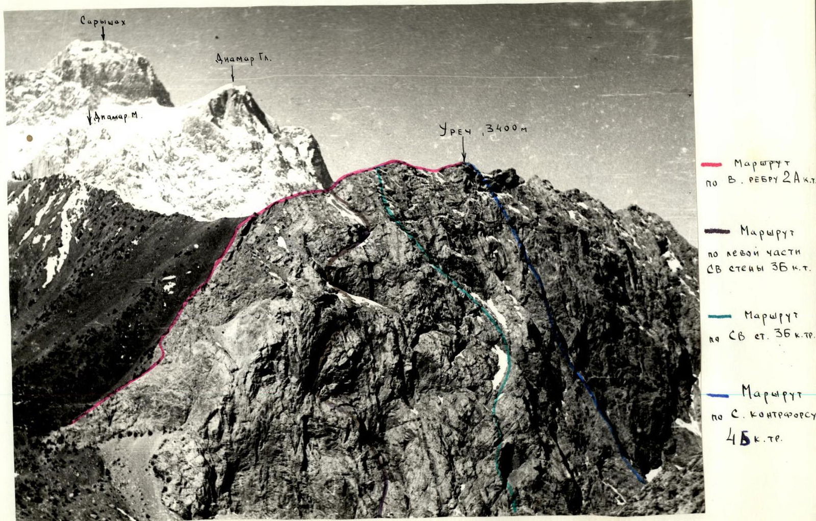
- Peak, its height, ascent route — p. URECH, 3400 m, via the Eastern Edge
- Estimated difficulty category — 2A cat. diff.
- Route characteristics: elevation gain — 500 m, total route length — 790 m, average steepness — 30°
- Pitons hammered: for belay — 2 pcs.
- Number of climbing hours — 6 h
- Number of nights and their characteristics: none.
- Team composition:
- Fomenko V.A. — leader, 3rd sports category,
- Gaynetdinov N.A. — participant, 3rd sports category,
- Arutyunov A.A. — participant, 3rd sports category,
- Farzaliyev P.M. — participant, 3rd sports category.
- Team coach: Avanesov G.Kh.
- Date of departure and return:
departure — May 2, 1981,
return — May 2, 1981
Brief Route Description
Approach from "Artuch" tourist center via the trail to Kulikalon lakes. Upon reaching the Kulikalon plateau, turn right towards the Eastern Edge, 2 hours. The beginning of the route is a small couloir, approached via narrowing scree.
The couloir consists of heavily destroyed rocks, with a steepness of 35–40°, length 40 m, alternating movement. From the couloir, exit to a ledge, right of the ridge. From the ledge upwards via destroyed rocks, exit to the edge (steepness 35°, 80 m), climbing of medium difficulty, belay via ledges simultaneously and alternately.
Further along the edge (60 m), through a crack-chimney with a plug (Em), exit to a ledge (Control Point).
Section length 120 m. Climbing of medium difficulty, sometimes easier, simultaneous and alternating belay.
Next, traverse gendarmes "head-on", exit to a wide scree shoulder. Along the shoulder, bypassing a rock outcrop on the left, exit to the ridge. Section length 150 m, simultaneous belay.
Along the pre-summit ridge, overcoming small gendarmes — exit to the summit, section length 300–350 m, simultaneous movement.
Descent from the summit to Chukurak pass and further down the trail to Kulikalon lakes, or right along the trail to Chukurak lake and further down to the tourist center. Descent takes 1–1.5 hours.
Route Characteristics Table
| Date | Designation | Avg. Steepness | Length | Relief Character | Difficulty | Condition | Weather Conditions | Pitons (Rock) | Pitons (Ice) | Pitons (Hook) |
|---|---|---|---|---|---|---|---|---|---|---|
| May 2, 1981 | R0–R1 | 45° | 25 m | Couloir | 2 | scree | good | 1 | – | – |
| R1–R2 | 35° | 70 m | Ridge | 2 | destroyed | good | – | – | – | |
| R2–R3 | 25° | 60 m | Edge | 1 | – | good | – | – | – | |
| R3–R4 | 60° | 5 m | Crack | 3 | monolithic | good | – | – | – | |
| R4–R5 | 20° | 30 m | Edge | 1 | destroyed | good | – | – | – | |
| R5–R6 | 25° | 40 m | Edge | 2 | monolithic | good | – | – | – | |
| R6–R7 | 45° | 60 m | Gendarme | 2 | monolithic | – | via ledges | – | – | |
| R7–R8 | 10° | 150 m | Ridge | 1 | scree | – | simultaneously | – | – | |
| R8–R9 | 35° | 120 m | Ridge | 2 | destroyed | – | via ledges | – | – | |
| R9–R10 | 15° | 100 m | Ridge | 2 | bouldery | – | via ledges | – | – | |
| R10–R11 | 5° | 50 m | Residual ridge | 3 | monolithic | – | – | – | – | |
| R11–R12 | 5° | 80 m | Ridge | 2 | bouldery | – | via ledges | – | – |

Descent to Chukurak pass.