Mt. Maria, 5B, via North-Eastern Ridge (A. Vakhmenin's route, 78)
Ascent Passport
Ascent category — technical. Ascent area — Fann Mountains, Zarafshan Range. Peak, its height, ascent route — Mt. Maria, 4970 m, via north-eastern ridge, 5B category of complexity, 3rd ascent of the route.
Route characteristics:
- Height difference — 1460 m
- Length of sections with 5–6 category of complexity — 1425 m
- Average steepness of the route — 60°
- Average steepness of the most complex sections — 80–90°
Pitons driven:
| Pitons driven | For belaying | ITO |
|---|---|---|
| rock | 89 | 5 |
| chocks | 65 | 4 |
| bolt | 0 | 0 |
| ice | 32 | 0 |
Time taken to reach the summit — 25 hours.
Number of bivouacs and their characteristics:
- one excellent
- one sitting
Name, qualification of the team leader and participants:
- Dronov Yu.V., Candidate Master of Sports — team leader
- Fevziev R.F., Candidate Master of Sports
- Smirnov G.K., Candidate Master of Sports
- Babaeshko V.P., Candidate Master of Sports
- Valiulin E.A., Candidate Master of Sports
- Mumdzhi T.M., Master of Sports of the USSR, senior instructor — team coach
Date of departure and return:
- departure — July 24, 1979
- return — July 26, 1979
Geographic and Sporting Characteristics of the Area
Mt. Maria, named by the well-known researcher Paganucci A.B., is located in the crest of the Zarafshan Range, known in this area as the Fann Mountains due to its geographical, geomorphological, and climatic features. Here, the Zarafshan Range sharply changes its latitudinal direction, turns south, and approaches the Gissar Range. From Mt. Mirali, a spur runs west with peaks Maria, Omar Khayyam, Rudaki, Aurandag, Saryshakh, and Gaznych, known as the West Fann Range. The part of the Zarafshan Range from Mt. Adamtash to Mt. Mirali and the part of the West Fann Range from Mt. Mirali to Mt. Aurandag form a powerful arc with steep northern faces and significant glaciation, closing the Kulikalon cirque from the south. This wall is often called the Kulikalon Wall.
Geologically, the Kulikalon Wall has two zones by height:
- the lower zone is composed of monolithic marbleized limestones and dolomites
- the upper zone is represented by metamorphic, thin-layered, strongly altered limestones with horizontal and inclined bedding
The northern orientation of the Kulikalon Wall determines its harsh character. Receiving virtually no solar heat, the wall is strongly cooled and retains large masses of snow and ice, descending significantly below the snow line (4000 m). For example, on the north-eastern slopes of Mt. Maria, there are two snow-ice belts (3600–3800 m and 4000–4250 m), separated by rock faces. Above 4300 m, there is a large hanging glacier oriented north and extending almost to the summit tower.
The steepness of the rock faces contributes to safe passage since falling stones and ice fly over these rock ledges. The north-eastern ridge (more accurately — northern), rising steeply from the 4400 m mark (above the second snow-ice belt), is also safe to traverse as its left part (in the ascent direction) consists of rock faces, and the right part slopes towards the hanging glacier.
The climate of this region is sharply continental with usually stable good weather in the summer. However, there are seasons with unfavorable weather. For instance, in the summer seasons of 1970 and 1972, precipitation was frequent, and in the summer of 1974, there were frequent rains. The summer season of 1979 was characterized by unstable weather and relatively high snow cover on the routes.
The first ascents in the Fann Mountains were made as early as 1937 by groups led by Kazakova, Lukomsky, Gusev, and Mukhin. However, the region gained wide mountaineering recognition after being thoroughly described by researcher and popularizer of the Fann Mountains, Paganucci A.B., as well as well-known mountaineers P. Karpov, U. Usenov, V. Egorov, L. Kiselev, V. Sedelnikov, F. Zhitenev, and others.
The first ascents on Mt. Maria from the north side date back to 1968. F. Zhitenev laid a route through the central part of the NE wall, and V. Smrchek ascended via the northern ridge.
In 1970, a group of Tashkent mountaineers led by A. Shabanov ascended the north-eastern ridge of Mt. Maria.
Currently, many ascents are made on Mt. Maria via the simplest path — the northern ridge, category 4B, and less frequently — via the north-eastern wall, category 5B (Zhitenev's route).
The route on Mt. Maria via the north-eastern ridge, category 5B, was repeated only this year by a team of mountaineers from Karaganda.
Preparation for the Ascent
The north-eastern ridge on Mt. Maria, upon careful examination from below (as the route description was absent), appears to be relatively safe, technically complex, combined, very logical, and beautiful. With significant length and considerable steepness, the north-eastern ridge has approximately equal lengths of complex rock and snow-ice sections. All these factors, along with the fact that the route had been traversed only twice, determined the team's decision to ascend Mt. Maria via the north-eastern ridge.
As training ascents, the team completed several routes of 3–4 category of complexity and a sporting ascent on Mt. Aurandag via the NE wall, category 5B.
Considering the combined nature of the route, over two days, the team conducted training sessions on the Mirali glacier to practice and improve technical skills and techniques for overcoming steep snow-ice slopes using modern ice equipment: titanium ice screws (tubular with special sharpening), twelve-tooth crampons, ice hammers, and ice axes made according to the best domestic and foreign samples.
It is also worth noting that during ascents, the team successfully used chock stones (stoppers, segments, hexes, etc.) for belaying and creating ITO, alongside a wide range of titanium rock pitons. The ratio of chock stones to pitons used during the ascent was approximately 1:1.
During the training sessions on the Mirali glacier, located near the northern slopes of Mt. Maria, and on July 23.1979, visual observations were made through a 12x field binocular to study the route and the regime of falling rocks and ice.
Based on these observations, the following tactical plan for the ascent was developed:
- Day 1 — Approach to the route. Processing of the lower rock belt. Overnight stay on the moraine under the route.
- Day 2 — Passage of the lower rock belt. Passage of the second rock belt. Overnight stay at the base of the snow-ice "knife."
- Day 3 — Passage of the snow-ice "knife," pre-summit rock slopes, and ascent to the summit. Descent from the summit via the northern ridge.
- Day 4 — Reserve day.
The team followed this plan to ascend Mt. Maria via the NE ridge. Observations of the ascent and radio communication with the group were maintained from the base camp on Lake Bibi-Djanat by a team consisting of:
- Mumdzhi T.M. — Master of Sports of the USSR, senior instructor
- Avanesov G.Kh. — 1st category, instructor
- Kamalov V.K. — 1st category
- Gornostaev V.V. — Candidate Master of Sports
Observations of the ascent were conducted almost continuously during daylight hours through an 18x field binocular. Radio communication was maintained at the designated time for the Fann Mountains region (control — 3 times a day, emergency — 3 times a day) using VHF radios "Vitalka."
Ascent Diary
July 24, 1979 The group of five climbers (Dronov Yu.V. — leader, Fevziev R.F., Babaeshko V.P., Smirnov G.K., Valiulin E.A. — participants) leaves the base camp on Lake Bibi-Djanat. After 2 hours, the group stops on the Mirali glacier, 250–300 meters from the start of the route.
Our observations show that the lower part of the route is hit by individual rocks until 14:00. After resting and reviewing the start of the route again, the "duo" Dronov — Fevziev begins processing the lower belt. After descending the glacier, we approach the start of the route. The advice from the Karaganda Regional Sports Committee gathering group is very helpful. We immediately approach the start of the route and see the path to the first rock belt. The route begins with a 60 m rock wall. Dronov starts moving up the wall. He works very attentively due to the abundance of limestone dust on small ledges. He passes the rock wall (section R0–R1) at a good pace, sets up belays, and with top-rope belay, takes Fevziev. Further, the steepness of the 1st rock belt increases to vertical, with wet patches visible on the wall. Fevziev starts moving up the internal angle. The internal angle is vertical, with a small cornice visible in the middle. Chock stones (stoppers, segments) work well, but movement is slow due to limited small holds, and in some places, holds are absent, requiring ITO. The cornice is passed with great difficulty. The belayer warns that only 3 m of rope remain, but there is no convenient ledge for taking in the internal angle. One has to take a sitting position in the "harness." The belay rope hangs in the air, and Dronov ascends using two jumar clamps and top-rope belay to retrieve the ropes. The first climber continues, with very complex climbing. Another rope length of complex climbing follows through a wet internal angle, and again, there is no convenient ledge for the second climber (section R1–R2). After securing the belay to two stoppers, the second is taken in a "harness." Further movement is along a 40 m crack, with chock stones working well. The wall's steepness is slightly less than vertical, but climbing remains very complex. Finally, after 40 m, we reach a narrow ledge where one person can stand (section R2–R3).
The last two ropes are retrieved. After the ledge, movement is along a smoothed chimney. The chimney is very complex, with some holds missing, requiring ITO. After 25 m, the chimney ends, and we reach a good, comfortable platform under a small cornice. We could continue, but we know that beyond the next rope length lies a snow-ice slope exposed to ice fragments from the upper cirque with a hanging glacier. Rocks could also fall from the eastern wall of the northern ridge of Mt. Maria. Here, under the cornice, we are completely safe. After securing the belay well and resting a bit, we begin descending.
The rest of the group (3 people), having prepared dinner, watch our descent. We quickly descend and, leaving excess equipment at the start of the route, run down the glacier to the eagerly waiting comrades. We are very tired but satisfied — the lower belt of the route is processed. Over a dense dinner, we share impressions of the 1st rock belt and discuss the next day. We decide to go to bed early as tomorrow promises to be a very challenging day.
July 25, 1979 We wake up at 4:30 AM, have a hearty breakfast, and depart at 5:45. We quickly approach the start of the route, and at 6:00, the first climber begins moving up the fixed ropes. The night was frosty, and our ropes are icy. Everyone moves using two jumar clamps. The first climber has a tough time clearing the ropes of ice. We quickly pass the processed part of the 1st rock bastion in 2 hours. The Fevziev — Valiulin team leads forward. After passing 1.5 rope lengths on icy, non-steep rocks, we reach a snow-ice slope. This section must be traversed in the morning and very quickly due to the risk of rock and ice fall. We quickly pass the snow-ice slope and are under the cover of the 2nd rock belt. Fevziev — Valiulin lead forward. Immediately, we face very complex rocks. Movement begins along a steep rock shelf, then traverses left, reaching a crevice ending in a 1.5 m cornice. Movement is challenging due to ice filling the crevice. We have to use ice equipment (hammer, ice screws). We pass two rope lengths and reach a steep 15 m ice slope. The first climber goes in crampons with ice hammers. Quickly passes the steep ice slope and reaches a monolithic rock wall. The rocks are very complex, cold, and hands are numb, but the morning sun gradually warms us.
We pass the wall and reach a rock shelf. Dronov — Babaeshko — Smirnov lead forward. We then ascend a non-steep but very hard ice slope, which ends in a rock ridge. The rocks are icy; movement is very difficult. Water starts dripping from the "ram's foreheads," further complicating progress on the rocks. We reach a steep 15 m ice slope, then move along a rock but dry slope. At the end of the slope, we see a good platform. The team is a bit tired, consults, and decides to stop for lunch. Meanwhile, Valiulin — Smirnov process a 70 m wall ending in a 10 m chimney. After processing two complex rope lengths, they descend. By this time, we have brewed strong tea, and everyone has a hearty lunch — there's still much work ahead.
We quickly pass the fixed ropes and reach a snow-ice slope. The sun is now warm, and movement on the slope slows due to wet snow and underlying blue ice. We have to use ice hammers and soon reach a rock ridge. The rocks are partially icy, with a 60 m wall and cornice above.
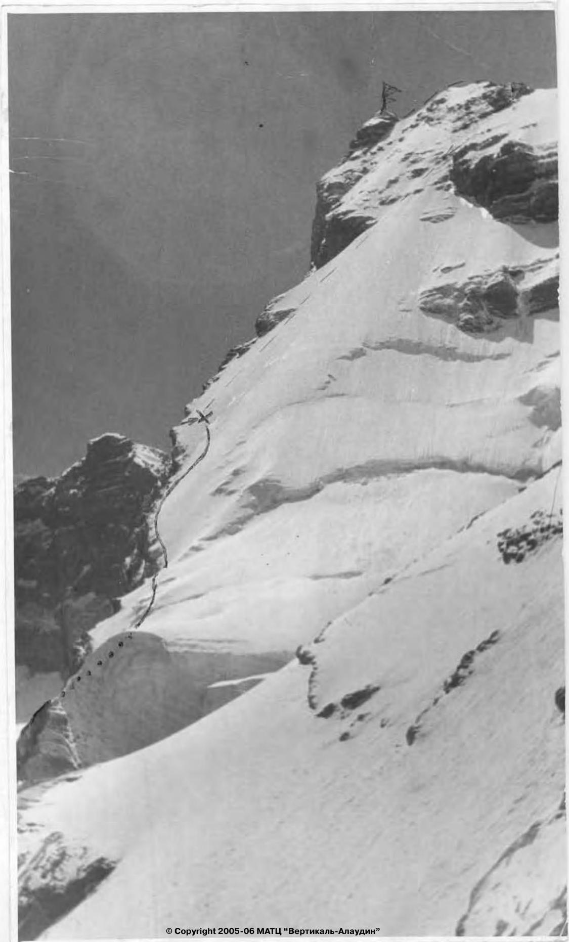
Dronov leads first. Slowly but surely, he passes the wall section and reaches under the cornice. Using ITO, he passes the cornice and traverses a steep, smoothed slab to ice. It's hard for the last climber (section R14–R15). We then pass a 15 m ice wall and a snow-ice slope to reach icy rocks. There's still plenty of daylight; we continue. In some places, we use ITO as the rocks are covered in rime. We pass a large monolithic "boulder." Smirnov works first, alternating with his partner Babaeshko. Confidently passing the "boulder," Babaeshko reaches the ice "knife." Morale is high; we feel the summit is near. We ascend via icy rocks and the icy "knife" to reach tile-like and crumbling rocks. Movement is very slow. The first climber must work carefully, clearing each hold of debris and checking its reliability.
We reach the control cairn established at the exit of the route via the NE wall and NE ridge, but do not remove the note.
To the right of the cairn, under a cornice, is a sitting bivouac. We decide to bivouac, set up belays, and make ourselves comfortable.
The sound of the primus stove is pleasant; we all gather around it, discussing the day's events. After brewing strong tea, we have a hearty dinner. We decide to rise early tomorrow as part of the route must be traversed early in the morning or after noon when the sun no longer illuminates the pre-summit section. Some of us are already sleepy, feeling pleasant fatigue after a challenging day. Snuggled together, we quickly fall asleep.
July 26, 1979 Yura Dronov wakes everyone up in the morning. The primus stove is already buzzing, and water is boiling. We have breakfast. Fevziev leads first, carefully checking each hold. The rocks are icy; it takes a lot of time to clear each hold of ice and remove debris.
The pre-summit ridge is now visible; morale is high.
We reach strongly crumbling rocks. Dronov works first, passes 40 m, and takes in the second team. The last 40 m are passed by Fevziev, and a quarter of an hour later, the entire group is on the summit.
After a short rest, packing excess equipment into backpacks, we begin descending from the summit via the northern ridge. The descent is familiar to us, and by 23:00 the same day, we are back at the base camp on Lake Bibi-Djanat.
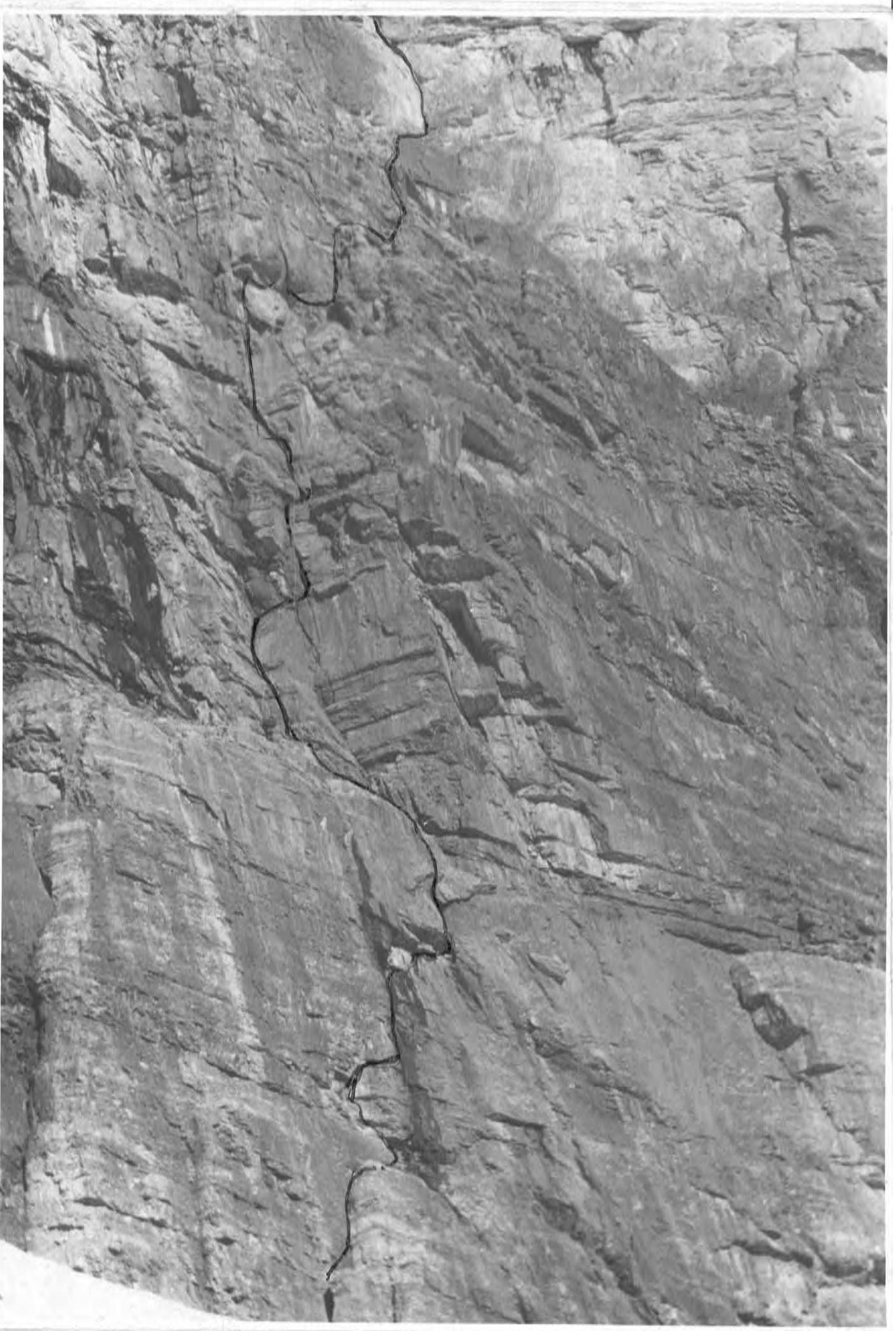
Maria SHAB 1st rock belt
Section R19–R22
— exit point to the ridge used by F. Zhitenev's group (1969)
— path taken by A. Shabanov's group
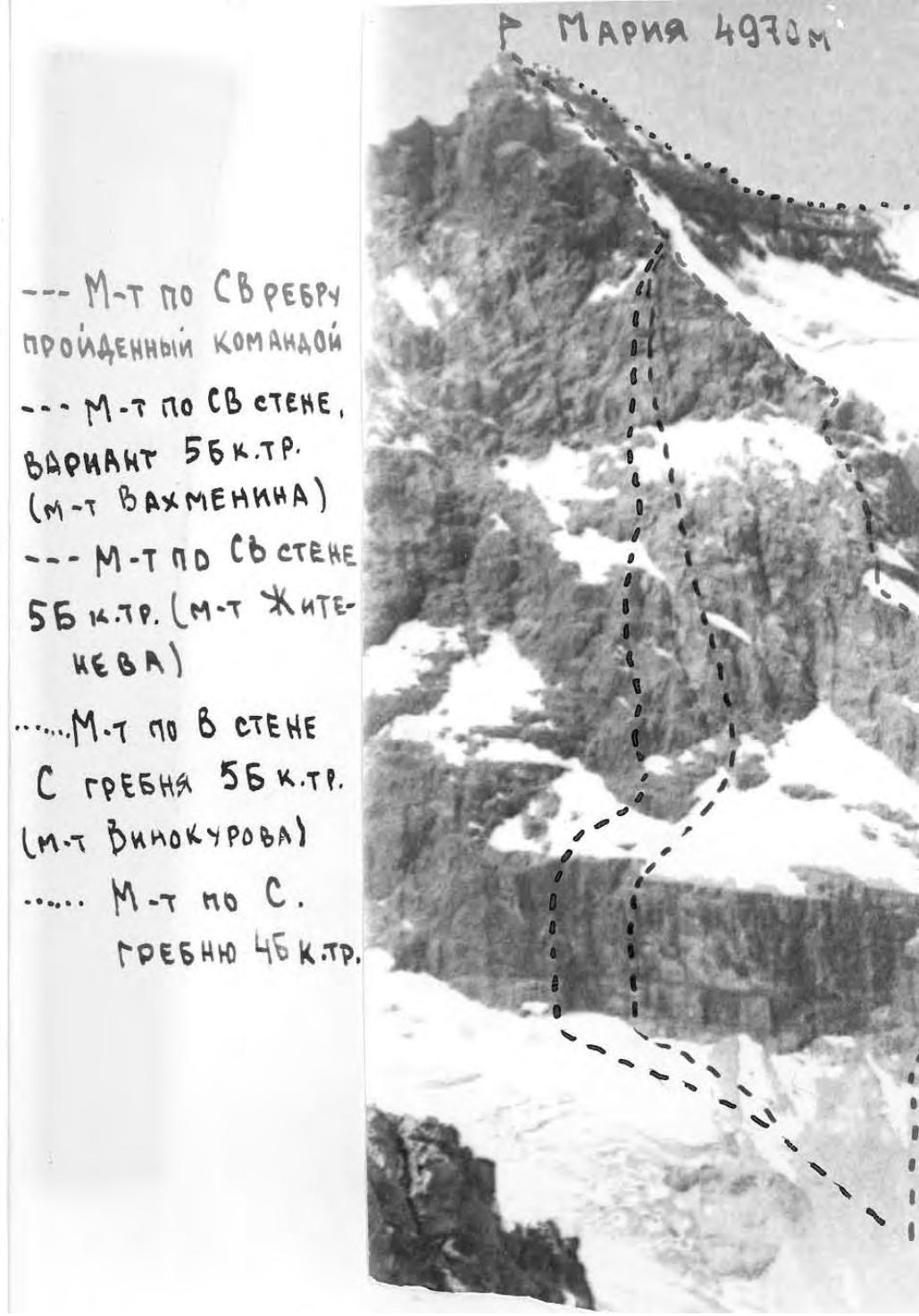
MAРИЯ 4970 м
— Route via north-eastern ridge taken by the team — Route via north-eastern wall, variant 5B category of complexity (A. Vakhmenin's route) — Route via north-eastern wall 5B category of complexity (F. Zhitenev's route) — Route via eastern wall from the ridge 5B category of complexity (Vinokurov's route) — Route via northern ridge 4B category of complexity
© Copyright 2005–06 MATC «Vertikal-Alaudin»
| date | обозначен | крутизна | протяжённость | Характер рельефа | трудность | состояние | Условия погоды | крючья скальных | крючья закладок | крючья шлямбурных | крючья ледовых | Время выхода, остановки |
|---|---|---|---|---|---|---|---|---|---|---|---|---|
| 24.07.1979 | R0–R1 | 70 | 60 | Стена | 4 | монолит | ясно | 4 | 2 | – | – | 14:00 |
| R1–R2 | 90 | 80 | Внутренний угол с карнизом | 6 | монолит | ясно | 5 / 11 | 3 / 11 | – | – | 19:00, ходовых часов — 5 ч | |
| R2–R3 | 80 | 40 | Щель | 5 | монолит | ясно | 2 | 4 | – | – | ||
| R3–R4 | 85 | 25 | Камин | 6 | монолит | ясно | 2 / 1 | 14 / 1 | – | – | ||
| 25.07.1979 | R4–R5 | 60 | 60 | Бараньи лбы | 3 | Мокрые, местами обледенелые | ясно | 3 | 2 | – | – | |
| R5–R6 | 40 | 300 | Снежно-ледовый склон с выходами скал. | 3 | Плотный фирн, обледенелый | ясно | выступы | 3 | – | 1 | ||
| R6–R7 | 55 | 50 | Снежно-ледовый склон | 4 | Лед, плотный фирн | ясно | – | – | – | 2 | ||
| R7–R8 | 80 | 85 | Скальная полка, расщелина с карнизом | 5 | Монолит, обледенелые скалы | ясно | 4 | 3 | – | – | ||
| R8–R9 | 70 | 55 | Ледовый склон 15 м, скальная стена | 5 | Натечный лед, монолит | ясно | 5 | 1 | – | 2 | ||
| R9–R10 | 50 | 100 | Скальная полка, ледовый склон, скальный гребень | 4 | Натечный лед, обледенелые скалы | ясно | 2 | 1 | – | 1 | ||
| R10–R11 | 65 | 25 | Ледовый и скальный склон | 5 | Плотный лед, монолит | ясно | 2 | 2 | – | 1 | ||
| R11–R12 | 80 | 80 | Стена, камни | 5 | Разрушенная, камин обледенелый | ясно | 3 | 3 | – | 2 | ||
| R12–R13 | 55 | 250 | Снежно-ледовый склон, скальный гребень | 4 | Раскисший снег, разрушенные скалы | ясно | 3 | 4 | – | 1 | ||
| R13–R14 | 60 | 110 | Скальный гребень, снежно-ледовый склон | 4 | Разрушенный, лед под слоем раскисшего снега | ясно | 3 | 3 | – | – | ||
| R14–R15 | 80 | 100 | Стена с карнизом, крутая плита | 5–4 | Монолитные мокрые скалы, местами обледенелые | ясно | 8 / 1 | 5 / 1 | – | – | ||
| R15–R16 | 65 | 85 | Ледовая стена, снежно-ледовый склон | 5 | Плотный лед | ясно | – | – | – | 7 | ||
| R16–R17 | 60 | 350 | Обледенелые скалы | 5 | Натечный лед | ясно | 8 / 1 | 6 / 1 | – | 5 | ||
| R17–R18 | 70 | 80 | Большой жандарм | 5 | Монолит, местами обледенелый | ясно | 6 | 2 | – | – | ||
| R18–R19 | 45 | 120 | Ледовый нож | 5 | Обледенелый | ясно | – | – | – | 10 | 6:00 | |
| R19–R20 | 55 | 150 | Разрушенные черепичного строения скалы | 5 | Разрушенные, обледенелые | ясно | 5 | 8 | – | – | 22:00, 15 часов хода | |
| 26.07.1979 | R20–R21 | 55 | 150 | Разрушенные черепичного строения скалы | 5 | Разрушенные, обледенелые | ясно | 6 | 7 | – | – | 6:00 |
| R21–R22 | 75 | 80 | Сильно разрушенные скалы | 4 | Разрушенные, обледенелые | ясно | 8 | 2 | – | – | На вершине в 11:00, ходовых часов — 5 ч |