Ascent to Peak "Maria" - 4970 m, 5B-6B cat. diff.
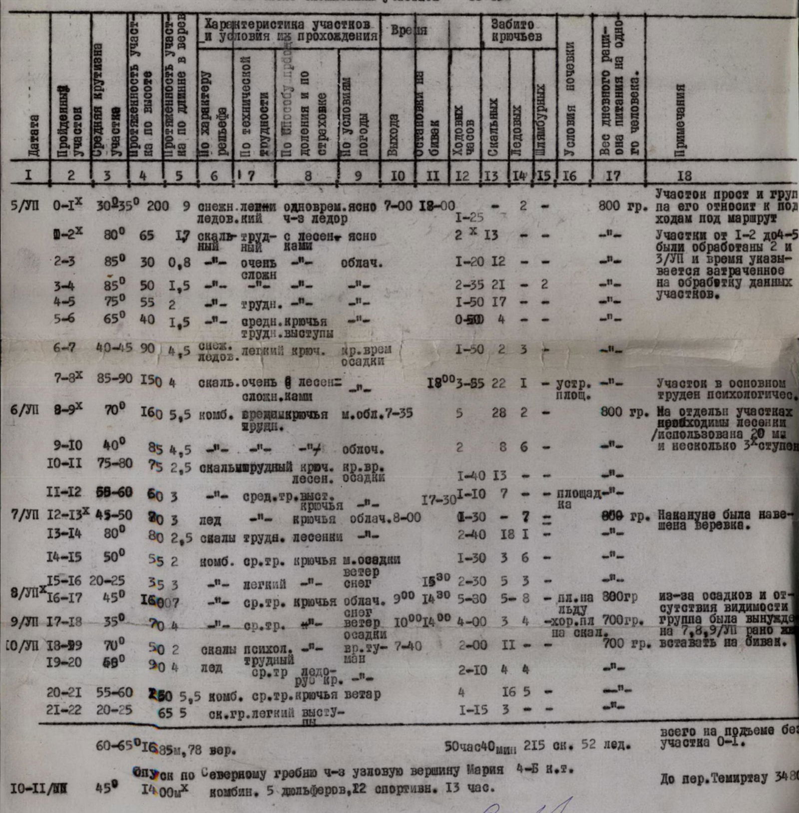
For the 1970 CS DSO "Spartak" mountaineering championship
via the right ridge.
The Spartak Tashobl Soviet DSO mountaineering section's training camp took place from June 23 to July 22 in the northwestern part of the Fann Mountains.
Ku likalon Valley, 1970. In 1969, a group of GDR mountaineers led by Karl Hentz climbed Peak Maria via the northern ridge and then traversed Peak Mirali, rating this traverse as a climb of the highest difficulty category.
The Tashobl Soviet DSO "Spartak" team followed the Leningrad climbers on the N-NE wall. During pre-season preparations, the group couldn't find a description of the route and only received verbal consultations from eyewitnesses of the ascent. Thus, the ascent was not much different from a first ascent.
VIII. Organization and Tactical Plan of the Ascent
By July 2, the team completed a training and reconnaissance climb on Peaks "Svobodnoy Korei" (3B cat. diff.) and "Severny" (4A cat. diff.), both with predominantly rocky routes.
The final composition of the assault team was determined. It included:
- A.V. Shabanov - MS - team coach
- Yu.A. Varakin - CMS
- N.S. Shabanova - MS
- V.V. Vinichenko - 1st sports category
- Yu. Matsuk - 1st sports category
- A.E. Popov - 1st sports category
The team planned to attempt the main variant - the N-NE wall of Peak Maria - and had a backup plan - a first ascent of the central rib of the Kulikalon wall. The backup plan was abandoned due to its illogical nature, as it led not to the summit but to a significant elevation (4400 m) between Peaks Maria and Aurandat.
Based on the study of the planned route, the following tactical plan was developed:
- Preliminary processing of the first rocky belt of the wall.
- On the first day of the assault, the first rope team would quickly pass the already processed rocky belt, and while the rest of the group followed, they would start processing the second rocky belt.
- The pioneers would overcome the most complex sections using 2-3 step ladders. To facilitate and speed up the passage of long complex sections for the rest of the participants, 12 or 20 meters ladder is hung.
- The wall was planned to be climbed with three bivouacs and one on the descent. Since the wall faces N-NE, an early bivouac setup is necessary. While the group sets up the bivouac, one rope team would process the route. Climbing the already processed section in the morning allows climbers to warm up and prepare for more serious work.
- To maintain communication between the assault team and observers, a detailed observation and communication schedule was agreed upon. The observation team was located 1 km from the route at the tongue of the Marin glacier. Four observers were always present in the tent; starting at 6:00, a pair would conduct observations, changing every two hours; at 21:00, after receiving a signal from the group, observations would cease.
Communication with the group was maintained visually and using flares. In case of an emergency, there was an agreement with the Samar kand tourist base of the Samar kand Regional Tourism Council to communicate with the Samar kand Regional Council of DSO "Spartak".
IX. Route Description
- On July 1, at 8:00, carrying all necessary equipment, including 320 m of rope, A. Shabanov, V. Vinichenko, and Yu. Matsuk set out to process the route.
50 m below the base camp, we cross the river and follow the trail upstream along the eastern slope. F luorite. After 50 m of walking, we cross back to the right orographic bank of the river. The trail goes steeply up to a densely overgrown juniper moraine.
After 1 hour of walking - at the lower Dukha khe Lake, from where the wall of Peak Marin is visible. We traverse a narrow isthmus between the upper and lower lakes; all vegetation disappears. We ascend the moraine composed of crushed stones until we reach a mixture of small scree and snow, which leads us to the ridge of the lateral moraine of the glacier, 400 m from the base of the first wall belt.
The approach took 2 hours. We set up a site for the assault camp.
Section R0-R1: 15 minutes along the moraine ridge to a destroyed rocky outcrop. 1 rope length with simultaneous insurance through outcrops. We traverse the snowy slope to the right, ascending to a rocky island. 15 m from the rocks, ice appears (step cutting, two screw hooks). We overcome the rant-ilyuvt and reach the rocks.
Section characteristics:
- Length: 10 rope lengths
- Time taken: 1 hour 24 minutes
- 2 ice screw hooks overcome
See photo #1
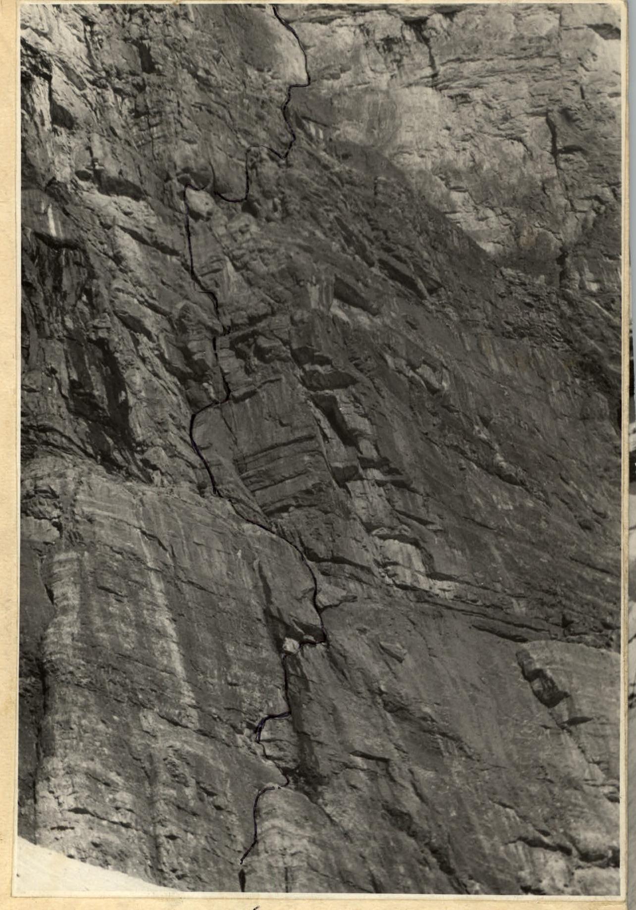
Section R1-R2. From the junction of the rocky island with the wall, an internal angle is visible, going vertically up through the entire rocky belt.
The ascent begins through a crack with sufficient holds, but there are destroyed and overhanging sections that require careful insurance. After 25 m, the first overhanging section is overcome using wooden pitons and a 2-step ladder. The rock is more solid, 3 meters of relatively easy climbing, and then another difficult section, again using ladders, we reach an almost horizontal ledge (20-30 cm). From it, 5-6 m left and up to the next ledge. Along the ledge under the waterfall (almost dry in the morning), we approach the internal angle.
Section length:
- 1.7 rope lengths
- 2 hours
- 13 rock pitons
- 4 two-step ladders
See photos #1, 2
Section R2-R3. The rocks are of a blocky granite type; the smoothed internal angle is slightly inclined with two small cornice; on each, a ladder is hung.
The angle leads to a large cornice:
- by driving intermediate wedges with ladders, we bypass it;
- we ascend the left side of a small conical vertical chimney (angle).
The first climber, A. Shabanov, had to stop due to a heavy downpour with a thunderstorm.
The section is extremely difficult - 30 m, 85°, 12 rock pitons, 1 hour 20 minutes. See photos #1, 2, 3.
In total, 3.5 hours were spent processing the route that day. The rain didn't stop, and we descended to the camp.
On July 3, V. Vinichenko and Yu. Matsuk processed the route.
Section R3-R4. V. Vinichenko leads. The chimney gradually turns into a crack, ending at a triangular cornice (small and smoothed holds). On its right side, there is an internal angle (4 m); it has signs of piton placement by previous climbers. The angle leads to an inclined slab, where guides are visible; Yu. Matsuk follows.
Further, left and up along a convex mirror (2 drilled pitons), to the left of a diagonal cornice to its junction with a horizontal one. Here, a wide crack; driving wooden and duralumin wedges into it, we reach under a strongly overhanging ledge (shaped like a lynx's head). The ledge is passed on the left (4 ladders). A good ledge allows the entire group to rest.
The section of 1.5 rope lengths was completed in 2 hours 35 minutes, 21 rock pitons were driven, including 2 drilled pitons, and 9 ladders were hung. (This section is the most challenging on the route so far).
Section R4-R5. Along the ledge, 0.5 rope lengths, under an overhanging chimney (12 m). It has many holds; in the middle, there is a plug, which we bypass on the left side (2 ladders). The chimney splits; we take the left exit to a small ledge. Under it, there is a cornice. We pass it and, via an internal angle, reach a platform that can accommodate three people. Along the ledge, we approach under a step-like internal angle, leading under a small cornice. Further, along a smoothed groove, we bypass an overhanging slab on the left. From the slab, along a vertical crack (11 m of very difficult climbing), we reach a wide internal angle, leading to a snowy ledge.
Section characteristics:
- 2 rope lengths
- 1 hour 50 minutes
- 17 rock pitons
- 4 ladders
The weather: overcast, short-term precipitation.
The route processing was completed; necessary hangings, pitons, and two ropes were left in place. The rope team began their descent, hanging 40 m of rope at the top, then 120 and 80-meter ropes. Processing 240 m of the route took 9 hours in total.
July 4. A sunny morning. Swimming in the lake, final check of all necessary equipment on the route, packing food to a minimum weight. Daily ration for 5 days - 800 g, for 2 reserve days - 600 g.
At 15:00, we depart from the base camp, quickly reaching the assault tent. We finalize individual route options.
On July 5, at 7:00, we bid farewell to the observers. We cover the processed part of the route in three hours; despite two long ladders, we have to pull up backpacks in three places. We drop 120 and 80-meter ropes, unnecessary pitons, and 30 carabiners to the observers. Everything falls without touching the rocks.
Meanwhile, the first rope team, A. Shabanov and N. Shabanova, proceed to the next section:
Section R5-R6. Along the boundary between rocks and snow (15 m), we approach rocks with a stepped character. The first wall (7 m) is climbed directly through a crack onto a ledge; from there, we approach a gutter-like couloir. The couloir leads to a snow-ice belt (insurance mainly through outcrops).
Section characteristics: 1.5 rope lengths, 30 minutes, 4 rock pitons, 60-65°.
Section R6–R7. Along the snow-ice slope, we ascend to a rocky island. We exit onto rocks with step-cutting (8–10 m). The rocks are of a "ram's forehead" type, gentle but heavily smoothed; we have to drive petal-shaped pitons for insurance (20 m). We return to the ice, traverse right, and approach the second rocky belt.
Section characteristics: 4.5 rope lengths, 1 hour 50 minutes, 3 ice screw and 2 rock pitons, 40–45°.
Section R7–R8. We traverse the lower part of the bastion along "ram's foreheads" to the right, behind the waterfall, and exit onto an inclined ledge. Above the ledge, there is a heavily destroyed section; we bypass it via a frozen chimney-gutter (10 m of very difficult climbing). To the left, there is a semblance of a ledge; we approach the waterfall and climb along its edge (8 m). All clothing is wet. We traverse the waterfall to the left and, via a 4–5-meter vertical internal angle, exit onto an inclined ledge. From the ledge, there is a smooth, vertical wall with water flows. A vertical narrow crack runs through its center; we climb it, freezing and chilled. A. Shabanov, alternating with Yu. Matsuk, drives petal-shaped pitons on ladders and ascends to a slab. From the slab, there is a 5-meter overhanging wall. Yu. Matsuk stands on Yu. Varakin's shoulders, drives a titanium piton, and exits onto a ledge. We pull up the backpacks. 25 m of wet rocks of medium difficulty lead to a site where a tent platform can be built. We construct the platform under an overhanging wall; on its left side, there is a stream of clean water (we hurry to create a reserve using all available containers). The rope team, A. Popov and Yu. Varakin, goes on a reconnaissance of the further route but returns soon due to light snowfall. The section is difficult, especially psychologically, 5 rope lengths, 3 hours 25 minutes, 22 rock and 1 ice screw piton, 5 ladders, about 90°.
In total, the group worked for 9.5 hours that day, ascending 500 m.
July 6. Departure at 7:35.
Section R8–R9. Along easy rocks (15 m), we exit onto ice (1.2 rope lengths). Further, along wet and smoothed rocks (1.5 rope lengths) to a flattening. We traverse left into a chimney (its left side is covered in ice). The chimney (17–20 m) leads to an inclined, snow-filled ledge. A. Popov follows, alternating with N. Shabanova. From the ledge, there is about a rope length of easy rocks. Further, there is a sharp rocky Mani r, an overhanging, slippery knife edge. The overhanging section is climbed via complex climbing along an internal angle, under an overhanging triangle. Along the left edge, we ascend to the triangle (very difficult climbing, 4 points). Further, the knife edge turns into a rounded tower. The rocks are difficult but are climbed without ladders (a 20-meter ladder was hung to facilitate and save time). The upper part of the tower is climbed relatively easier along blocky rocks. The rocks on this section are calcite with excellent friction. Climbing the right knife edge results in skin abrasion on the fingers. Along a vertical internal angle (6 m), we exit onto a gentle ridge. Below the ridge, an icefall opens.
Section characteristics: 6.5 rope lengths, over 5 hours, 28 rock, 2 ice pitons, 7 ladders, average steepness 70°.
Section R9–R10. Along the ridge, we approach an ice slope (1 rope length of easy rocks). The ice slope is climbed with piton insurance, leading under a rocky balcony. Under the rocks, there is formed ice; we have to cut steps (5 m). Section length: 25 m. Steep rocks (difficult climbing) lead us to a balcony. Along the balcony, we approach a rocky rib. To the right of the rib, there are ice falls with rocky outcrops; to the left, there are "ram's foreheads" covered with formed ice.
Section characteristics:
- Length: 1 rope length, 25 m
- Average steepness: 40°
Section R10–R11. Initially, we ascend along easy rocks (0.5 rope lengths). Then, there is an overhanging section; we bypass it on the right via an internal angle (0.68 rope lengths), 75–80°, leading to a diagonal cornice. The cornice is overcome in its upper left part without significant difficulties along a wide internal angle with an overhanging section above (ledge). The ledge is passed via a crack using wooden wedges and ladders, and we exit into a window. From it, along a ledge to the right, we reach the ridge.
Section characteristics: 2.5 rope lengths, 1 hour 40 minutes, 3 ladders, 75°, 13 rock pitons. See photo #4.
Section R11–R12. Further along the ridge:
- 2 rope lengths of medium rocks, with sections of 3–4 m of difficult rocks;
- we move right - 1 rope length of destroyed easy rocks, with almost horizontal but smooth slabs, where small stones are scattered.
We move in independent rope teams with a gap. Not reaching the ice slope 6–8 m, we find a suitable site for a platform but realize the scree is unstable; we move slightly right, where we find remains of a bivouac by the pioneers.
Section characteristics: 3 rope lengths, 1 hour 10 minutes, 7 rock pitons, 55–60°. For the day, we worked a little over 10 hours.
- 12 rope lengths
- Height gain: 350–400 m
On the same day, V. Vinichenko and A. Popov processed three rope lengths of ice.
July 7. In the morning, cloudiness increased but remained high. In the valley, the sun is visible. Our observers, seeing us on the ice slope, lit flares, which we barely spotted, and nobody felt warmer immediately.
Section R12–R13. We exit from rocks onto a steep oval ice ridge. After 0.5 rope lengths, we start traversing to the right. The steps prepared in the evening are partially covered with snow, but the hung perils help us move quickly to the rocks. At the rocks, the ice is particularly steep; we approach a protruding rocky rib.
Section characteristics: 3 rope lengths, 30 minutes, 7 ice pitons, 45–50°.
Section R13–R14:
- Rocky rib (12 m) with sufficient holds, leading to a narrow ledge.
- We move along it under an overhanging section to the right, to a niche, where the leader changes.
- The overhanging section is bypassed on the right, with limited holds, and strongly overhangs. Along a slab, we approach the second overhanging section, which is overcome using ladders.
- From the rock, a huge slab protrudes, forming an overhanging cone-shaped chimney.
- Climbing the left main part of the rock is impossible due to its negative slope and lack of cracks.
- The slab split from it consists of multiple vertical slabs; it's unclear what holds them together, and this entire heap is negative.
- We ascend the chimney, frequently driving pitons, and hang a ladder.
- At the top of the chimney, there is a plug; we pass it on the left side.
Near the plug, the rocks flatten. The chimney turns into an internal angle and leads to a ledge. We pull up the backpacks and, along the ledge, approach the ice slope.
Section characteristics: 2.5 rope lengths, 80°, 18 rock and 1 ice piton, 6 ladders (a 20-meter ladder was used). The section is difficult, 2 hours 40 minutes.
Section R14–R15. Along the ice slope (1 rope length) on the front teeth of crampons, we reach an ice fall (11 m), overcome it, and traverse left onto rocks. The rocks, of a "ram's forehead" type, lead to a rocky ridge.
The section is of medium difficulty (2 rope lengths), 50–55°, 6 ice and 3 rock pitons, 5 hours. Strong wind, slight precipitation.
Section R15–R16. Along a gentle ridge with several small ascents, we move upward. The rocks are smoothed; there are few cracks for driving pitons - they need to be cleaned from snow (in good weather, this section wouldn't present any difficulty).
The weather worsened; heavy snowfall starts, and snow pellets begin to fall from the ice slope. We need to find a bivouac site; a small ascent of the ridge from under the ice leads to a narrow scree comb, where we build a platform. Two participants, V. Varakin and Yu. Matsuk, process the further section, but visibility reduces to 4–5 m, and they descend to the tent after hanging 2.5 rope lengths.
Section characteristics: 3 rope lengths, 25–30°, easy, 5 rock and 2 ice pitons. For the day, about 7 hours - 10.5 rope lengths, we ascended 250 m. For three days, the main part of the wall was passed, with the most difficult sections completed.
July 8. There are no breaks in the clouds; it's gloomy and cold. We wait until 9:00; it lightens slightly, and we depart on the route.
Section R16–R17. Along the rope hung the day before, we traverse left of the ice fall onto a steep ice cyclon. The steps cut the day before are covered with a thick layer of fresh snow. After 3 rope lengths, we exit onto rocks. The upper edge of the N-NE wall is often cut by ice gullies. The rocks are covered with fresh snow; to move and drive pitons, we need to clear them. We frequently change leaders due to constant transitions from rocks to ice and back. On the ice, movement is difficult; fresh snow clogs the crampons. It's very cold; wet feet in crampons freeze. White snow alternates with short-term precipitation. After lunch, snowfall intensifies. We had to descend one rope length down to an ice "cliff," cut by its edge like a knife, with avalanches falling from the slope. To the northeast, the cliff drops with a 5-meter vertical wall onto a rocky ledge about 2 m wide. On the sides, steep couloirs descend. The ledge is inclined; we have to dig into the ice and build a protective wall from the most windy sides.
Section characteristics: combined, 7 rope lengths, 8 ice and 5 rock pitons, 5.5 hours, medium difficulty, 45°.
July 9. Wind, overcast. In the valley, the sun appears occasionally; it's hard to believe we're in the Fanns, as all our consultants emphasized that bad weather is rare here. Seeing the sun in the valley, we're sure the "rare exception" has ended, and with hope, we depart on the further route at 10:00.
Section R17–R18. We traverse an ice gully (2 rope lengths) to the left, to a rocky ridge leading to a red bastion. The rocks are covered with ice and snow; we move along the boundary between rocks and ice. Along an internal angle, we ascend to the ridge; the angle is heavily smoothed; along the ridge, we approach the bastion. 5 m below, to the left of the ridge, there is a ledge, protected from the wind and falling stones by an overhanging wall of the bastion.
The entire group descends to the ledge, and the rope team continues upward. After a rope length, they realize there's no further ascent. The weather worsens again; snowfall starts, but the ledge remains dry - the wall serves as a good roof. The group names this bivouac "swallow's nest" for its coziness.
Section characteristics: about 4 rope lengths, 4 hours of work, 4 ice and 3 rock pitons. (In good weather, traversing the ice gully would be the only difficulty).
July 10. There are breaks in the clouds. We depart at 7:40.
Section R18–R19. Along the right part of the bastion, via vertical walls (3–4 m), we ascend with a slight traverse to the right along snow-covered inclined ledges. There's a high risk of falling; cracks are filled with ice; we drive mainly large titanium pitons. We exit onto a rocky ridge and, along rocks of medium difficulty, approach a snowy ridge.
Section characteristics: about 2.5 rope lengths - 2 hours, 11 rock pitons, 70°. Psychologically difficult. Clouds frequently roll in, reducing visibility.
Section R19–R20. Along the snowy ridge with two steep ascents, we move with insurance via an ice axe. Steps are difficult to cut due to a layer of loose snow on dense firn.
The upper ascent:
- is icy, covered with a thin firn crust;
- is climbed by N. Shabanova on tiptoes without step-cutting;
- uses ice screw pitons for insurance.
Clouds rise, and we see our teammates on the northern ridge, ascending to the summit via the 4B cat. diff. route. Between gusts of wind, we hear their voices, and working becomes more cheerful.
The rib gradually turns into an ice wall. V. Vinichenko traverses along cut steps to the left onto a rocky ledge. The ledge is very inclined, with 6 m of snow. The wall leads to the next scree slope, where almost the entire group can gather.
Section characteristics: 5 rope lengths, 45–50°, 4 ice and 4 rock pitons.
Section R20–R21. Along a very steep slope, following rocky outcrops, we ascend to the summit ridge. The outcrops are shaped like horizontal steps; we hope to find small platforms but realize there aren't any. We move mainly on ice and climb the fourth and fifth, largest outcrops, along rocks of medium difficulty, where there are several platforms sufficient for two participants. After passing the 5th outcrop, we traverse right, following a horizontal ridge of small rocky outcrops, and ascend under an indistinct rocky couloir.
In the lower part, the couloir is wide; in the upper part, it narrows, ending at a rocky wall. The rocks are not complex, but there's a lot of fresh snow. We move mainly with loop insurance. The final wall is climbed directly - 10 m of snowy slope - and we're on the summit ridge, where we're met by teammates descending from the summit, and compote and crackers are welcome as never before.
Section characteristics: 6.5 rope lengths, average steepness up to 55–60°, 16 rock and 5 ice pitons - about 4 hours of work.
The last climber to reach the ridge is V. Varakin. Someone aptly called him a "hardworking laborer." It's hard to deny: almost the entire route, he went last, performing "black" work - cutting and sending hooks upward in a timely manner. And he's not the team's best rock climber. Yet, we only heard a calm, reassuring voice among his teammates, climbing through frost, rocks, and snow: "Varakin - choose, secure - hammer strike - and choose again!"
Section R21–R22. Along a destroyed ridge with small gendarmes, bypassing them on the right, we approach a saddle. From the saddle to the summit - along a sharp ridge with a steep 7-meter wall at the bottom, we exit onto the summit. The summit is sharp; the entire group can't fit around the cairn. The leader secures the rope and writes a note. Participants take turns approaching the cairn, and each looks down into the more than 1.5 km deep wall, with the azure surface of Lake Dukha khe directly below.
At 13:30, we begin our descent along the lower northwest ridge.
After 15 minutes, we pick up our left-behind backpacks and, 10 minutes later, catch up with the second group descending via a dülfer rappel from a gendarme to the saddle between the main and nodal peaks. Another sporting and gentle ridge leads us to the nodal peak. We bypass it and, at 8 pm, reach the second group's tent. A strong wind with blowing snow begins. We quickly set up our tents and light the primus stove.
On July 11, from the nodal peak, we descend north along an ice slope, then along a rocky ridge with 5–9 dülfer rappels and several sporting descents via the 4B cat. diff. route. At 20:30, we're on the Temir-Tau pass. Two hours later, we're welcomed back at our base camp with flares, a cake, and delicious borscht.
The descent took about 14 hours in total, and we left:
- 1 ice piton
- 12 rock pitons
Table
Main characteristics of the ascent route to Peak Maria via the N-NE wall, 5B-6B cat. diff., 4970 m: height difference - 1685 m, including the most complex sections - 480 m. Route steepness - 60–65°, including the most complex sections - 80–85°.