Ascent Passport
1. Ascent class: technical
2. Ascent area, ridge: 5.3. Zaravshan Ridge
3. Peak, its name, height, ascent route: p. Maria (4970 m)
Via the northern counterfort of the western ridge
4. Proposed difficulty category: 5B, second ascent
5. Route characteristics: height difference 1670 m
Length of sections 5–6 km (traverse 795 m) Average steepness: 65°
6. Pitons driven: for belay:
- Rock — 98
- Ice — 19
- Chocks — 36 For anchors and hanging belays:
- Rock — 8
- Ice — 12
7. Number of climbing hours: 28
8. Number of bivouacs and their characteristics: one on the ascent – lying, one on the descent – lying.
9. Surname, name, patronymic of the leader, participants and their qualification
| Surname, name, patronymic | Qualification |
|---|---|
| Andreev Vladimir Ivanovich | — CMS |
| Ivashev Vadim Karnilovich | — MS USSR |
| Parshin Vladimir Sergeevich | — CMS |
| Rabinov Feliks Grigorievich | — CMS |
10. Team coach: Ivashev V. K.
11. Dates of departure and return:
- July 27, 1980
- July 29, 1980
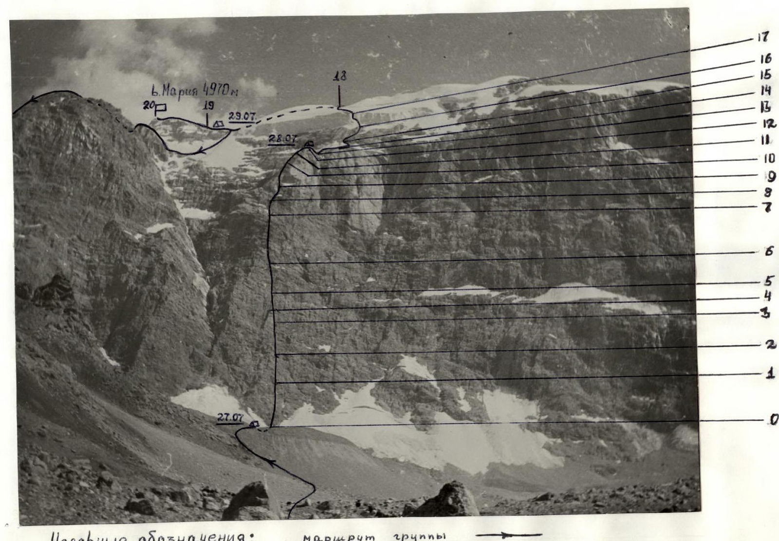
TABLE of main characteristics of the ascent route to p. Maria via N counterfort 8 ridge 5B cat. diff.
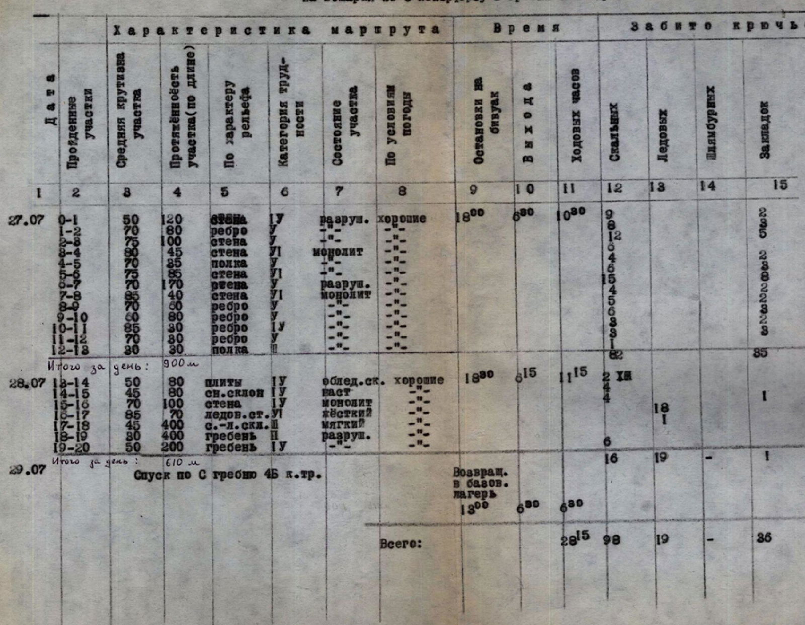
| Date | Sections traversed | Average steepness of section | Length of section (by length) | By terrain character | Difficulty category | Condition | Weather conditions | Stops at bivouac | Departure | In climbing hours | Pitons driven: Rock | Pitons driven: Ice | Pitons driven: Chocks |
|---|---|---|---|---|---|---|---|---|---|---|---|---|---|
| 27.07.80 | 0–1 | 50° | 120 m | wall | 1B | destroyed | good | 9 | |||||
| 1–2 | 70° | 80 m | edge | 1 | 8 | ||||||||
| 2–3 | 75° | 100 m | wall | 1 | 12 | ||||||||
| 3–4 | 80° | 45 m | wall | 6 | monolith | 4 | |||||||
| 4–5 | 70° | 35 m | ledge | 1 | 1 | ||||||||
| 5–6 | 75° | 85 m | wall | 6 | 15 | ||||||||
| 6–7 | 70° | 170 m | wall | 1 | destroyed | ||||||||
| 7–8 | 85° | 40 m | wall | 6 | monolith | ||||||||
| 8–9 | 70° | 60 m | edge | 1 | 5 | ||||||||
| 9–10 | 60° | 80 m | edge | 1 | 4 | ||||||||
| 10–11 | 85° | 30 m | edge | 1 | 3 | ||||||||
| 11–12 | 70° | 80 m | edge | 1 | 3 | ||||||||
| 12–13 | 30° | 30 m | ledge | 1B | 18:00 | 6:30 | 10:30 | 11 | 8 | ||||
| Total for the day: | 900 m | 82 | 85 | ||||||||||
| 28.07.80 | 13–14 | 50° | 80 m | slabs | 1B | icy rock | good | 2 | |||||
| 14–15 | 45° | 80 m | snow slope | 2 | crust on snow | 18:30 | 1:15 | 11:15 | 4 | 1 | |||
| 15–16 | 70° | 100 m | wall | 1 | monolith | 1 | |||||||
| 16–17 | 85° | 70 m | ice wall | 5 | hard | 18 | 18 | ||||||
| 17–18 | 45° | 400 m | snow-ice slope | 4 | soft | 1 | |||||||
| 18–19 | 30° | 400 m | ridge | 2 | destroyed | 6 | |||||||
| 19–20 | 50° | 200 m | ridge | 1B | 16 | 19 | 1 | ||||||
| Total for the day: | 610 m | 19 | 19 | 1 | |||||||||
| 29.07.80 | Descent via S ridge | 4B cat. diff. | Return to base camp | 13:00 | 6:30 | 6:30 | |||||||
| Total: | 28 h 15 min | 98 | 19 | 36 |
Route description
July 26. In the second half of the day we left the camp and came to the moraine under the route in 2.5 hours, where we set up a bivouac.
July 27. We left the bivouac at 6:00, and after 30 minutes we were under the route, tied in, and started climbing. We quickly pass the first 120 m of the wall (0–1) with alternate belay on moderately difficult rocks.
The next section is an R1–R2 edge, climbing is difficult, there are few places to drive pitons. Another 100 m up a monolithic wall (2–3) and before us is a very difficult section R3–R4 — almost a sheer monolithic wall 85 m with a limited number of holds, after which we move along a narrow ledge 35 m R4–R5 to the next extremely complex section R5–R6 — 85 m monolithic wall.
After extreme climbing 170 m wall (6–7), despite its high complexity, is passed relatively quickly. Then we overcome another monolithic wall (7–8). 40 m of extreme climbing. And we come out onto an edge (8–9), along the monolithic rocks of which we move to its steepest part. The rocks here are very smooth, climbing is extremely difficult, mostly on friction.
Then follows:
- 30 m of climbing (10–11) along the steep part of the edge on friction;
- decrease in the steepness of the edge;
- 30 m of difficult climbing (11–12) — the last section leading to the "tooth" summit.
Behind the summit is a good platform. We'll spend the night here. Time is 18:00. The weather is good. To get water, we have to process another 30 m of the route and hang a belay on the ledge (12–13) to the slabs.
July 28, at 6:00 we leave the bivouac. We quickly pass and remove the belays. Steep slabs (13–14) with ice require great care.
The next section (14–15) is a snow slope of moderate difficulty: great steepness, thin crust, under which there is ice in places. From the snow we again go out onto the rocks. We move from left to right along a 100 m monolithic wall of medium difficulty (15–16) in the direction of the ice wall (16–17). This is the "key" of the route. 70 m of sheer ice is overcome by the first climber in 3 hours.
After the sheer section we quickly pass 400 m of snow-ice slope (17–18) and at 14:00 we come out onto the western ridge of p. Maria. The first 400 m of the ridge (18–19) do not present a technical difficulty.
The last 200 m of the western ridge (19–20) of medium difficulty are passed very carefully (the rocks are heavily destroyed) with belay through ledges, and sometimes with pitons driven. At 18:50 we are on the summit.
We descend by the ascent route to the northern ridge and stop for the night.
July 29. The night is very cold. In the morning with the first rays of the sun we resume the descent.
We move along the northern ridge on the route of 4B cat. diff.
We arrive at the base camp at 13:00.