- Climbing category — technical
- Climbing area — Fann Mountains, Pamir-Alay
- Climbing route with peak names and elevations: via the NE wall of Zindon 4800 m (O. Shumilov's route), second complete ascent
- Proposed difficulty category — 6B
- Route description: elevation gain — 1200 m, length of sections with 5–6 difficulty grade — 930 m, average steepness — 80°
- Pitons hammered: for belaying (for creating intermediate belay anchors): rock — 318/40, ice — 27, bolt — 7/14
- Total climbing hours — 57
- Number of bivouacs and their description: 3 semi-reclining nights in a tent
- Combined team of MOS DSO "Zenit" and "Trud"
- Surname, first name, patronymic of the team leader, participants, and their qualifications: SEDOV German Konstantinovich — Candidate for Master of Sports, KARZANOV Alexander Vasil'evich — Candidate for Master of Sports, BORISOV Boris Ivanovich — Candidate for Master of Sports, IVANCHIN Ivan Andreevich — Master of Sports, SHATILOV Vadim Nikolaevich — Candidate for Master of Sports
- Team coaches:
- VINOKUROVA Sofya
- IVANCHIN Ivan Andreevich
- Date of departure and return:
- departure July 29, 1979
- return August 2, 1979
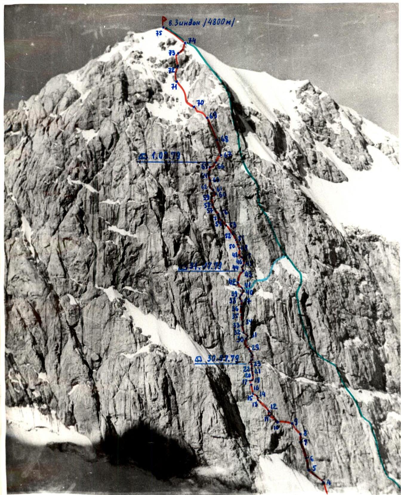
The group's route (following O. Shumilov's group)
Y. Emel'yanenko's group route
V. Andreev's group's traverse from O. Shumilov's route to Yu. Emel'yanenko's route

July 29. Route processing: Departure 6:30. Bivouac stop 19:00. Climbing hours for processing 10, rest and descent 2 h 30 min. 277 m covered. 50 pitons hammered.
| R# | Steepness (°) | Length (m) | Terrain characteristics | Difficulty | State | Weather | Rock | Ice | Bolt |
|---|---|---|---|---|---|---|---|---|---|
| R1 | 40 | 80 | Snow slope | 3 | Dense, hard firn | Good | - | - | - |
| R2 | 50 | 30 | Snow-ice slope, bergschrund | 3 | Thin layer of hard snow on ice, broken bridge across bergschrund | - | - | - | - |
| R3 | 60 | 7 | Rocks | 3 | Broken rocks with rimed ice | - | 2 | - | - |
| R4 | 80 | 10 | Inner corner | 5 | Rimed ice | - | 2 | - | - |
| R5 | 60 | 15 | Slab | 5 | -" - | - | 2 | - | - |
| R6 | 90 | 15 | Monolithic wall with a crevice | 6 | Rimed ice | - | 4 | - | - |
| R7 | 85 | 25 | Inner corner | 6 | Wet, with rimed ice | Good | 4 | - | - |
| R8 | 90 | 10 | Wall (1st control point) | 5 | Monolith | - | 4 | - | 1 |
| R9 | 85 | 15 | Inclined slab | 6 | Monolith, rimed ice | - | 6 | - | - |
| R10 | 100 | 10 | Horizontal interrupted crack on wall | 6 | Dry rocks | - | 6 | - | - |
| R11 | 90 | 15 | Slab, interrupted ledge | 5 | Monolith | - | 4 | - | - |
| R12 | 90 | 10 | Wall | 6 | Smooth rocks | - | 5 | - | - |
| R13 | 75 | 35 | Inclined ledge | 5 | местами rimed ice | - | 6 | - | - |
July 30. Departure 7:00. Bivouac stop 19:00. Climbing hours 12. 99.5 m covered. 67 pitons hammered.
| R# | Steepness (°) | Length (m) | Terrain characteristics | Difficulty | State | Weather | Rock | Ice | Bolt |
|---|---|---|---|---|---|---|---|---|---|
| R14 | 85 | 3 | Wall | 6 | Monolith | Good | 2 | - | - |
| R15 | 75 | 10 | Inclined ledge | 4 | -" - | - | 2 | - | - |
| R16 | 90 | 20 | Wall, II control point | 6 | Monolith | - | 6 | - | 2 |
| R17 | 85 | 10 | Wall | 6 | Monolith, smooth rocks | Good | 2 | - | 3 |
| R18 | 80 | 3 | Wall, traverse under cornice | 6 | Monolith | - | 2 | - | - |
| R19 | 120 | 1.5 | Cornice | 6 | -" - | - | 1 | - | 1 |
| R20 | 80 | 10 | Wall | 6 | -" - | - | 4 | - | - |
| R21 | 90 | 20 | Wall | 6 | Monolith, местами strongly smooth | - | 12 | - | 1 |
| R22 | 95 | 2 | Cornice | 6 | Monolith | - | 3 | - | 1 |
| R23 | 80 | 20 | Wall, exit to ledge with niche | 5 | Monolith, in upper part — scree on steep rocks | - | 5 | - | - |
July 31. Departure 8:00. Bivouac stop 19:30. Climbing hours 11 h 30 min. 189 m covered. 95 pitons hammered.
| R# | Steepness (°) | Length (m) | Terrain characteristics | Difficulty | State | Weather | Rock | Ice | Bolt |
|---|---|---|---|---|---|---|---|---|---|
| R24 | 100 | 1.5 | Cornice | 6 | Monolith | Good | 2 | 1 | - |
| R25 | 80 | 4 | Wall, III control point | 5 | -" - | - | 2 | - | - |
| R26 | 80 | 4 | Slab | 6 | -" - | - | 4 | - | - |
| R27 | 110 | 1 | Cornice | 6 | -" - | - | 2 | - | 1 |
| R28 | 80 | 10 | Inner corner | 5 | Rimed ice | Good | 4 | - | - |
| R29 | 90 | 8 | Wall | 5 | Broken rocks | - | 3 | - | - |
| R30 | 60 | 20 | Rocks | 5 | Broken rocks, местами rimed ice | - | 6 | - | - |
| R31 | 110 | 3.5 | Cornice | 6 | Monolith | - | 3 | - | 1 |
| R32 | 40 | 15 | Slab | 5 | Monolith | - | 3 | - | - |
| R33 | 80 | 30 | Wall, slab | 5 | Monolith | - | 6 | - | - |
| R34 | 100 | 2 | Cornice | 6 | -" - | - | 3 | - | - |
| R35 | 65 | 8 | Slab | 5 | -" - | - | 3 | - | - |
| R36 | 90 | 20 | Wall | 6 | -" - | - | 10 | - | - |
| R37 | 95 | 7 | Cornice | 6 | -" - | - | 8 | - | 1 |
| R38 | 80 | 3 | Wall | 5 | -" - | - | 4 | - | - |
| R39 | 95 | 2 | Cornice | 6 | -" - | - | 5 | - | - |
| R40 | 15 | 15 | Ledge | 3 | местами лед | - | 2 | - | - |
| R41 | 85 | 5 | Wall | 5 | Dry rocks | - | 2 | - | - |
| R42 | 65 | 10 | Broken rocks | 4 | Sections of ice, many «live» stones | - | 3 | - | - |
| R43 | 75 | 20 | Couloir | 4 | Strongly destroyed scree couloir | Good | 2 | - | - |
August 1. Departure 7:00. Bivouac stop 21:00. Climbing hours 14. 296 m covered. 123 pitons hammered.
| R# | Steepness (°) | Length (m) | Terrain characteristics | Difficulty | State | Weather | Rock | Ice | Bolt |
|---|---|---|---|---|---|---|---|---|---|
| R44 | 75 | 15 | Wall | 5 | Dry rocks, cracks | Good | 4 | - | - |
| R45 | 90 | 10 | Wall, crack | 6 | Dry rocks | - | 5 | - | - |
| R46 | 80 | 7 | Wall | 5 | Monolith | - | 3 | - | - |
| R47 | 90 | 8 | Wall, approach under cornice | 6 | -" - | - | 5 | - | 1 |
| R48 | 90 | 5 | Wall, traverse under cornice | 6 | Dry rocks | - | 3 | - | - |
| R49 | 90 | 10 | Crevice left of cornice | 6 | -" - | - | 3 | - | - |
| R50 | 95 | 3 | Cornice | 6 | Dry rocks, monolith | - | 7 | - | - |
| R51 | 75 | 10 | Wall, crevice | 5 | Dry rocks | - | 3 | - | - |
| R52 | 95 | 25 | Wall | 6 | Wall with small holds, some smooth sections; dry rocks | - | 11 | - | 1 |
| R53 | 75 | 30 | Ram's forehead | 6 | Dry rocks, almost no cracks for pitons | - | 4 | - | 1 |
| R54 | 80 | 15 | Slab, crevice | 6 | Wet rocks, crevice filled with rimed ice | Good | 5 | - | - |
| R55 | 85 | 15 | Smooth slab along crevice | 6 | Wet rocks, rimed ice | - | 4 | - | - |
| R56 | 110 | 3 | Cornice | 6 | Monolith, rimed ice | - | 5 | - | - |
| R57 | 80 | 15 | Slab with crevice | 5 | Rimed ice | - | 4 | - | - |
| R58 | 90 | 5 | Wall, crevice | 5 | Rimed ice in crevice | - | 2 | - | - |
| R59 | 80 | 20 | Wall with cornices | 6 | Dry rocks, exit to horizontal ledge with нависанием above it | - | 7 | - | - |
| R60 | -10 | 15 | Inclined ledge (traverse right down to stream) IV control point | 4 | Dry rocks, approach to large inner corner with stream | - | 3 | - | - |
| R61 | 75 | 10 | Slab | 5 | Red slab with crevice, dry rocks | - | 3 | - | - |
| R62 | 85 | 10 | Slab | 6 | Dry rocks, small holds | - | 4 | - | - |
| R63 | 90 | 20 | Wall | 6 | Dry, then — wet rocks, exit to small ledge for 2 people | - | 10 | - | - |
| R64 | 90 | 10 | Wall | 6 | Crevice, dry rocks | - | 4 | - | - |
| R65 | 75 | 10 | Wall, crevice | 5 | Exit to ledge, large chip off wall above | - | 2 | - | - |
| R66 | 75 | 25 | Ledge | 4 | Traverse along ledge, местами лед | Good | 2 | - | - |
August 2. Departure 7:30. Summit reached 17:00. Climbing hours 9 h 30 min (to the summit). 460 m covered. 70 pitons hammered.
| R# | Steepness (°) | Length (m) | Terrain characteristics | Difficulty | State | Weather | Rock | Ice | Bolt |
|---|---|---|---|---|---|---|---|---|---|
| R67 | 95 | 10 | Wall | 6 | Smooth rocks, few cracks | Good | 4 | - | - |
| R68 | 75 | 40 | Slab | 6 | местами scree with ice on slab | - | 8 | 2 | - |
| R69 | 70 | 60 | Wall | 6 | Ice on rocks | - | 8 | 7 | - |
| R70 | 45 | 50 | Rocks, ram's foreheads | 5 | местами ice and snow on ice | - | 6 | 4 | - |
| R71 | 45 | 60 | Snow-ice slope | 5 | Thin snow on ice | - | 1 | 8 | - |
| R72 | 50 | 30 | Ram's forehead | 5 | Wet rocks, местами iced | - | 6 | - | - |
| R73 | 60 | 30 | Couloir | 5 | Snow-ice | - | 5 | 2 | - |
| R74 | 45 | 30 | Ice slope with rock islands | 4 | Thin layer of snow on ice | - | 5 | 2 | - |
| R75 | 40 | 150 | Snow-ice slope | 2–3 | Dense snow | - | - | 2 | - |
Ascent Log
The group left the base camp at Alaudin lakes on July 28 and completed the approach to the route on the same day. In the evening, they managed to survey the entire route.
The group consisted of:
- three participants who had previously attempted to climb the NE wall but had to turn back due to technical issues.
The discussion of the observation results was brief and to the point. The tactical plan was finally approved.
July 29:
- the duo Karzanov–Shatilov, departing at 6:30, processed 180 m of rocks on the route and descended to the initial bivouac at 19:00.
- the remaining group members at the bivouac, along with observers, spent the day conducting a repeat observation of the wall's condition and regime, and also reviewed equipment and supplies for the ascent.
Three bivouacs were planned on the wall, with supplies for five days. The group took five ropes, agreeing that each participant's movement would be on a double rope.
- The first in the group climbed without a backpack.
- The others carried backpacks.
Provisions, necessary "hardware," a tent, a stove with fuel, kitchen utensils, and down jackets for bivouac were packed into the backpacks.
From personal gear, participants only carried spare socks in their backpacks. All clothing was on the participants, with only the first allowed to dress more lightly.
As the ascent showed, this tactic fully justified itself. Backpacks were light at the start. On the route, backpacks were not pulled but carried using a belay rope. In very difficult sections, the backpack was tied to a sling on the climber's belt.
July 30. Departure from bivouac at 7:00. Good snow conditions and pre-drilled steps allowed for quick altitude gain. The bergschrund and snow-ice slopes presented no significant challenges. At 8:00, the group was at the base of the wall. From here, only the beginning of the route was visible; the rest "hung" above.
TRAVERS WITH BACKPACKS ON R9–R10 presented particular difficulty. Other sections were easier, even on vertical sections, climbing with a backpack on a belay rope and with insurance took participants 25–30 minutes. Climbing was sometimes extremely difficult, sometimes using I.T.O.
Most challenging sections:
- R17
- R18
- R19
- R22
- R24
At 19:00, they reached a small ledge with a niche containing ice and snow on the left. Here, they could set up a tent for a semi-reclining night, if all gear was "loaded" into the niche. However, setting up the bivouac took two hours. The duo continued processing the route but soon had to descend due to water flow in the inner corner (R28).
July 31. Departure at 8:00. Weather was good, but very cold. Immediately challenging climbing. The first participant managed to pass the inner corner dry; the rest climbed under a gradually increasing stream. Changing the note in the control point was inconvenient; a comfortable ledge was just below, but a plastic flask hung on a bolt on a sheer face. Fortunately, it wasn't raining there.
The route followed a typical wall climb: wall, cornice, slab, wall. The main guideline was straight up with minor deviations from the vertical. Insurance was mostly on "shelves" where one person could stand on one leg.
By evening (18:30), they reached a good ledge suitable for camping (R40) but decided to continue; water was flowing, and the site didn't seem safe. A heavily destroyed couloir with many "live" stones (R43) led them to a safe ledge. Here, they could set up a tent, but a third of the tent was obstructed by a rock protruding from the wall, so:
- for two people, the night was sitting,
- for the others, semi-reclining.
There was no water. They descended 20 m down the previously placed belay ropes to fetch ice.
August 1. Departure at 7:00. Huge, vertically placed slabs loomed above. The bivouac had been safe. Rockfall occurred on the right, in the couloir, and flew out onto the rocky-snowy ledge leading to Yu. Emel'yanenko's route, which attracted attention with its relatively simple wall. However, that route also had a 6B difficulty grade and similar complexity.
Passing the "bottle" presented the greatest difficulty not on cornice sections but on the "ram's forehead" when exiting the top of the "bottle," where rocks were heavily smoothed and virtually lacked cracks for pitons.
On top of the "bottle," there was a possibility for a night's stay, with remnants of a platform under a tent, but the bivouac was not safe due to falling icicles.
From the site:
- left — up complex slabs,
- wet and местами iced,
- through a cornice and walls, they exited onto a narrow inclined ledge (R60).
On the slab (R55), 4 rock pitons were left, and a rappel anchor hung. On the right part of the ledge (above it), a plastic flask of the 4th control point hung in a stream of water. To the right of it, the number "7" was painted in white on the wall.
In the control point, they surprisingly found a note from the first ascensionists — the team led by O. Shumilov. It should be noted that after the rappel anchor on R55, they practically didn't encounter any human traces.
From the control point, they moved left-up-right on very complex slab-like rocks. Here, there was sometimes complex psychological climbing. Very steep.
Finally, they reached a long, narrow ledge (R66) where they found a spot to build a platform under a tent, which could accommodate only four; the fifth person spent the night 2 m from the tent on a ledge.
August 2. Departure at 7:30. Observers reported by radio that they were close to the summit. But there was no relaxation yet. Before them lay a virtually ice wall. This was the last, but very complex and lengthy, key section of the route, followed by a normal complex 56.
The pre-summit ice-snow ridge and then the slope presented no particular difficulties, and at 17:00, they reached the summit.
Descent via the snow-ice couloir between Zindon and Soan peaks took 6 hours.