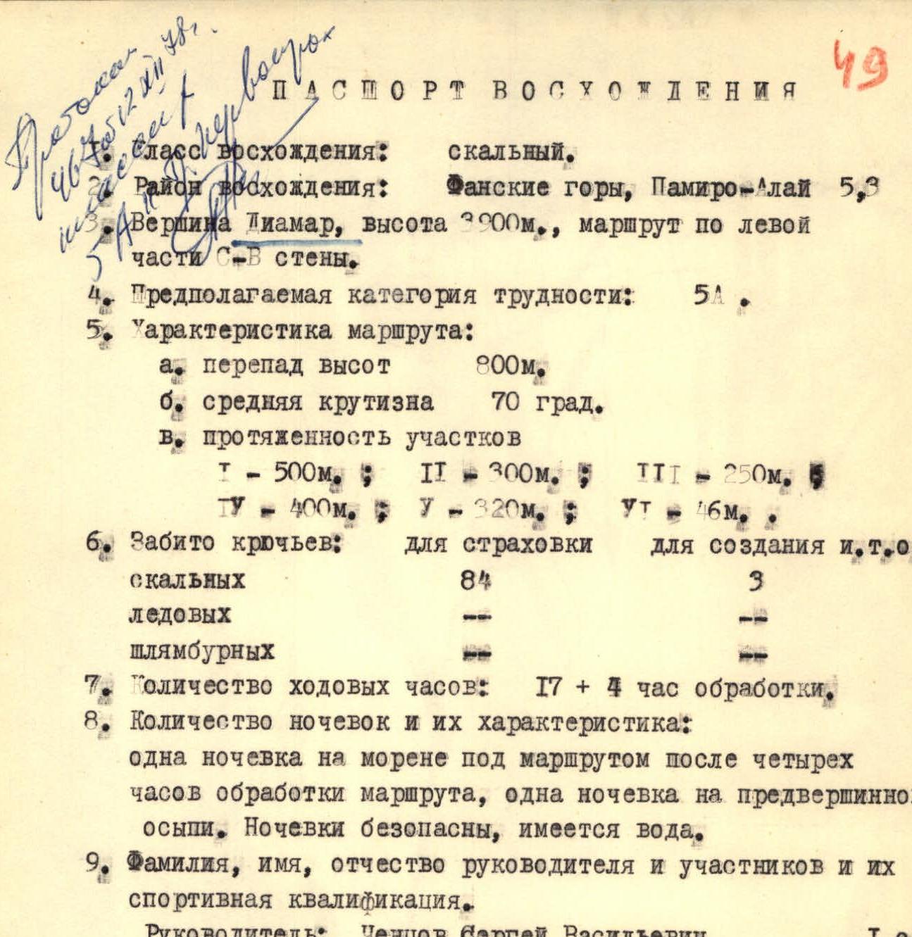
Ascent Record
- Ascent type: rock climbing.
- Ascent area: Fann Mountains, Pamir-Alay 5.3.
- Peak: Diamar, height 3300 m, route via the left part of the NE wall.
- Estimated difficulty category: 5A.
- Route characteristics: a. height difference 800 m. b. average steepness 70°. c. section lengths: * I — 500 m * II — 300 m * III — 250 m * IV — 400 m * V — 320 m * VI — 46 m
- Pitons hammered:
- for belaying: rock 84, ice —, bolt —
- for creating Intermediate Technical Objects (ITO): rock 3, ice —, bolt —
- Total climbing hours: 17 + 4 hours of route preparation.
- Number of bivouacs and their characteristics: one bivouac on the moraine below the route after four hours of route preparation, one bivouac on the pre-summit talus. Bivouacs are safe, water is available.
- Surname, name, patronymic of the team leader and participants and their sports qualification.
- Team leader: Chentsov Sergey Vasilyevich, 1st sports category
- Participants:
- Dunaev Vladimir Ivanovich, 1st sports category
- Zakharov Nikolay Nikolayevich, 1st sports category
- Panteleev Boris Leonidovich, 2nd sports category
- Savchenko Alexander Vasilyevich, 2nd sports category
- Team coach: Tulpanov Sergey Sergeyevich, Master of Sports of the USSR.
- Date of departure to the route and return:
- Departure to the route and its preparation: July 15, 1978.
- Return to the camp: July 17, 1978.
- Via the left part of the NE wall 5A (approximately).
- Via the N wall 5A.
- Via the N wall 4B.
- Via the NW buttress 5A.
- Via the NW ridge 5A.
- Via the W ridge 3B.
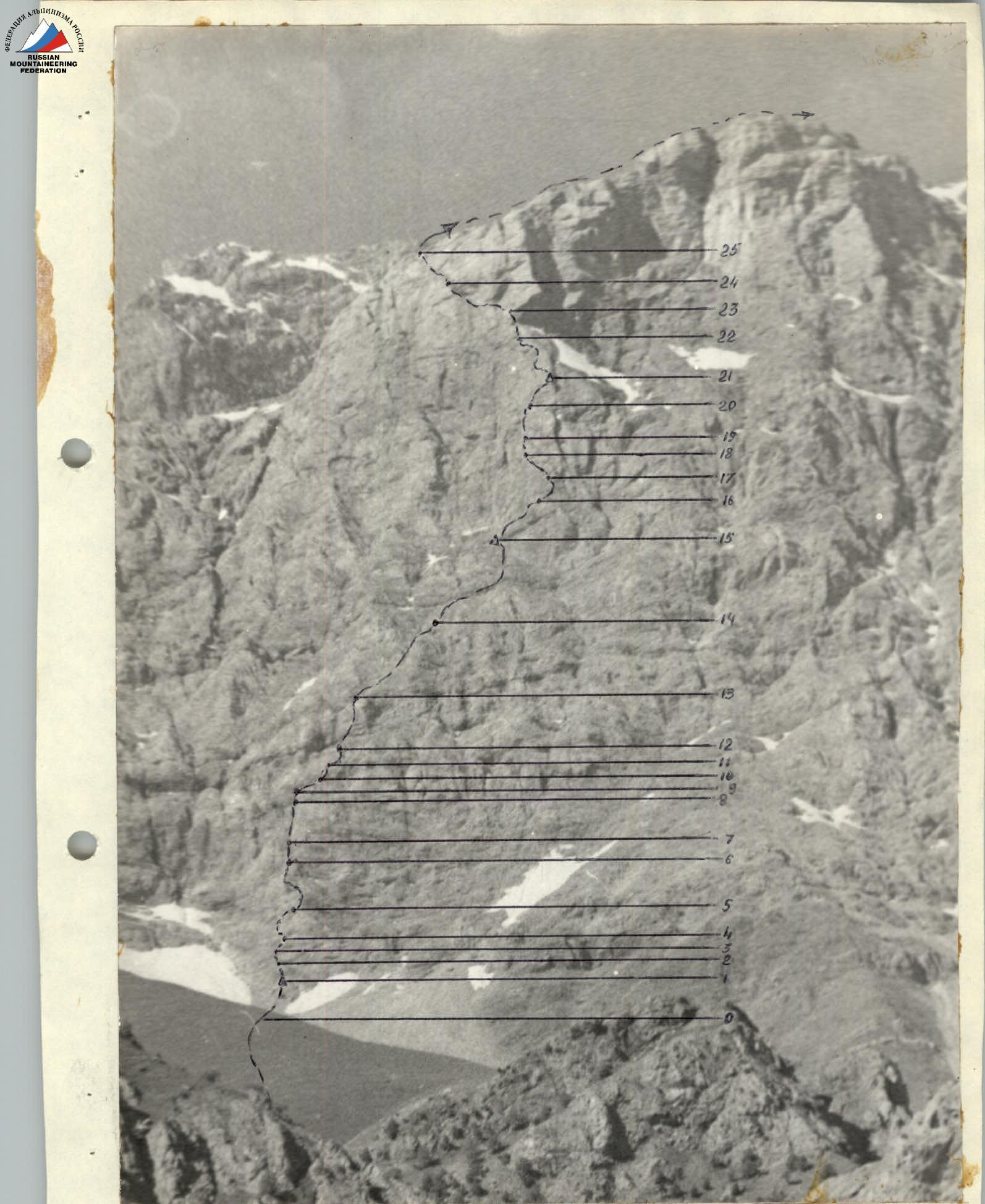
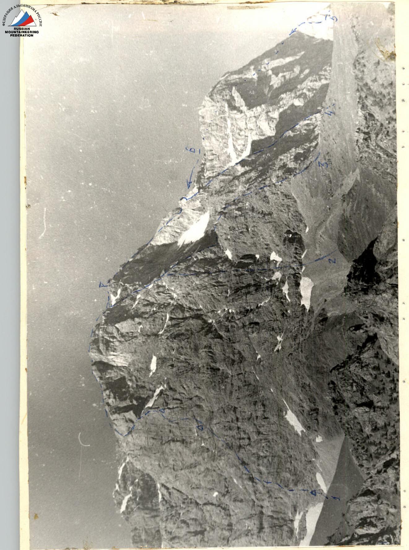
General View of the Route
Explanation of the table
(Route description)
The route starts at the lowest part of a prominent rock buttress.
- R0–R1: The first rope length goes up ledges and easy rocks, exiting onto a ledge below a cornice, with a cairn on the ledge.
- R1–R2: Left of the cornice, climb gentle rocks up to an internal angle.
- R2–R3: Climb the left wall of the internal angle below a grey slab that leads right.
- R3–R4: Climb the slab right and up below a grey wall with a rusty break. On the right lower part of the wall, there's a narrow ledge where the whole group can gather.
- R4–R5: Climb the wall 3 m up, then enter from left to right into a not clearly defined internal angle; very difficult, with difficult sack hauling.
- R5–R6: Climb a rock-strewn ledge right and up, then left across the wall and easy rocks towards a distinct buttress.
- R6–R7: Climb a yellow wall with grey streaks 20 m to the base of an internal angle with destroyed walls.
- R7–R8: Climb the internal angle up to a gap. Be careful! The rocks in the lower half of the angle are very destroyed.
- R8–R9: Then, make a very difficult exit onto a flake (to the right). Very difficult. Passed with a boost for the first climber. Ladders are used.
- R9–R10: Climb a stepped ledge with scree below a 20 m wall.
- R10–R11: Climb the wall, difficult climbing, exiting onto a narrow rock ledge.
- R11–R12: Traverse right along the ledge 20 m and then climb stepped rocks, like a ladder, up below a grey wall with a rusty "mallet".
- R12–R13: Climb below the "mallet" — first through a cleft, then up the wall left of the boundary between grey and rusty rocks.
- R13–R14: Climb right and up a not clearly defined ridge, leaving a stream bed to the left, 200 m into a gap between a triangular grey wall (left) and a rock "mallet" with the contours of a crocodile's head (right).
- R14–R15: Climb rocks of large formation and grey rocks like "sheep's foreheads" up towards a distinct steep buttress. ATTENTION! On the left along the path, on a ledge below a cornice (a bivouac site), there's the I control cairn.
- R15–R16: From the cairn up — first up a "sheep's forehead" 20 m, then up an internal angle left of a yellow "egg" to a sloping ledge that leads right.
- R16–R17: Climb to the end of the ledge and then up the wall towards a yellow wall with a dark spot to a cleft filled with earth.
- R17–R18: Climb left and up the cleft 30 m below a wall with a slit.
- R18–R19: Climb the slit up, difficult climbing, with monolithic rocks. Exit onto a ledge with scree. On the ledge — below a wall bounded by two vertical cracks.
- R19–R20: Climb up the right crack, which turns into a thin slit, and then into an internal angle with an overhang. Very difficult, ladders are used. Difficult sack hauling.
- R20–R21: Climb right and up internal angles — exiting to the II control cairn (40 m), a small ledge for two people.
- R21–R22: From the II control cairn, climb slightly left — up the wall towards a large rusty cornice and then across smoothed rocks below the cornice. Difficult climbing (60 m). There's a small bivouac site, with snow to the right below the cornice.
- R22–R23: Climb easy rocks (be careful! The rocks are smoothed) to the left edge of the cornice; to the left, a visible exit onto the E ridge of Diamar.
- R23–R24: Climb left and up smoothed slabs 80 m and then up the wall — exiting onto a rock shoulder. 40 m to the ridge.
- R24–R25: Climb straight up a grey wall or right and up a sloping cleft — exiting onto the ridge.
- R25–R26: Climb along the ridge to the summit 25–30 minutes. On the ridge, there are many bivouac sites, but no water.
The descent from the summit is via the moraine between the eastern ridges of Diamar and Sary-shah towards v. Aurondag and then along a trail to oz. Zeyrat (steep scree) and past oz. Chukurak to the "Artuch" alpine camp.
Route Characteristics Table
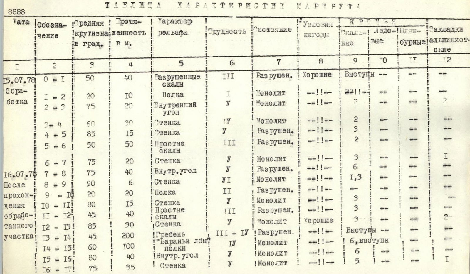
| Date | Label | Average steepness in degrees | Length in meters | Terrain character | Difficulty | Condition | Weather conditions | Rock pitons | Ice pitons | Bolt pitons | Climbing protection |
|---|---|---|---|---|---|---|---|---|---|---|---|
| July 15, 1978 | R0–R1 | 50 | 40 | Destroyed rocks | 3 | Destroyed | Good | Protrusions | — | — | — |
| Preparation | R1–R2 | 20 | 10 | Ledge | 1 | Monolithic | — | 2 | — | — | — |
| R2–R3 | 75 | 20 | Internal angle | 5 | Monolithic | — | 2 | — | — | — | |
| R3–R4 | 60 | 30 | Wall | 5 | Monolithic | — | 2 | — | — | — | |
| R4–R5 | 85 | 15 | Wall | 5 | Destroyed | — | 3 | — | — | — | |
| R5–R6 | 50 | 50 | Easy rocks | 3 | Destroyed | — | 2 | — | — | — | |
| R6–R7 | 75 | 20 | Wall | 5 | Monolithic | — | 3 | — | — | 1 | |
| July 16, 1978 | R7–R8 | 75 | 40 | Internal angle | 5 | Destroyed | — | 6 | — | — | — |
| After passing | R8–R9 | 90 | 6 | Wall | 6 | Monolithic | — | 1, 3 | — | — | — |
| R9–R10 | 20 | 20 | Ledge | 2 | Destroyed | — | 3 | — | — | — | |
| R10–R11 | 80 | 15 | Wall | 5 | Monolithic | — | 3 | — | — | — | |
| R11–R12 | 45 | 40 | Easy rocks | 3 | Destroyed | — | 3 | — | — | — | |
| R12–R13 | 85 | 30 | Wall | 5 | Monolithic | Good | 3 | — | — | — | |
| R13–R14 | 45 | 200 | Ridge | 3–4 | Destroyed | — | Protrusions | — | — | — | |
| "Sheep's foreheads" | |||||||||||
| R14–R15 | 60 | 100 | Ledges | 4 | Monolithic | — | 6, protrusions | — | — | — | |
| R15–R16 | 80 | 40 | Internal angle | 5 | Monolithic | — | 6 | — | — | — | |
| R16–R17 | 75 | 35 | Wall | 5 | Monolithic | — | 5 | — | — | 1 | |
| July 16, 1978 | R17–R18 | 70 | 35 | Ledge | 3 | Monolithic | Good | T | — | — | — |
| R18–R19 | 85 | 25 | Slit | 5 | Monolithic | — | 4 | — | — | T | |
| R19–R20 | 90 | 40 | Internal angle | 6 | Monolithic | — | 1, 6 | — | — | — | |
| R20–R21 | 70 | 40 | Internal angle | 5 | Monolithic | — | 4 | — | — | — | |
| R21–R22 | 75 | 60 | Wall, slabs | 5 | Monolithic | — | 8 | — | — | — | |
| R22–R23 | 70 | 20 | Wall | 5 | Monolithic | — | 2 | — | — | T | |
| R23–R24 | 70 | 80 | Smoothed rocks | 5 | Monolithic | — | 6 | — | — | — | |
| R24–R25 | 70 | 40 | Wall | 5 | Monolithic | — | 5 | — | — | — | |
| R25–R26 | 25 | 800 | Ridge | 1, 2 | Destroyed | — | Protrusions | — | — | — |


