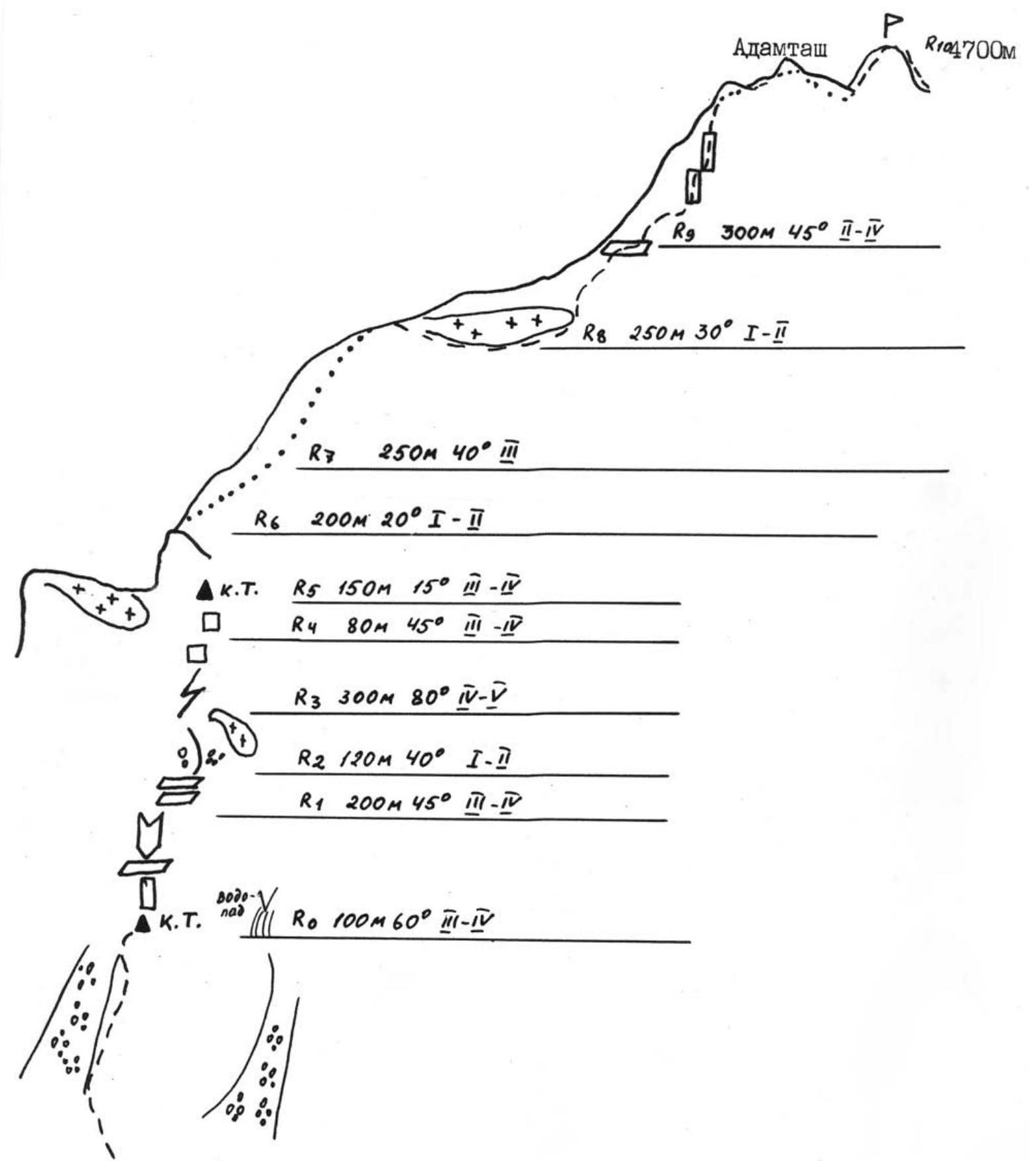
V. ADAMTASH, 4A, via the Eastern Ridge (V. Korotkov's route, 68)
From the Big Alaudin Lakes, follow the trail towards the Mutny Lakes until the turn to the Adamtash Pass. Go around the spur (on the right or left) and approach a characteristic white wall in the lower part of the spur above a large green shoulder. The landmark is a waterfall to the right. Here is the 1st control point. Put on climbing shoes and tie in here. R0–R1: 40 m at 70°, moderately difficult rock with good holds. Then enter a chimney (7–8 m) and continue to a black wall; bypass it and reach a ledge. Alternate belay. R1–R2: 100 m at 45°, moderately difficult rock. Alternate belay. R2–R3: 120 m at 30–40° scree, exit below a wall. Simultaneous movement. R3–R4: An internal corner (40 m at 70°) with loose rocks. Then move 10 m straight up and then 5 m right along a ledge, followed by 10 m left and up a slab. The landmark to the left is a grey wall. Continue 40 m right and up at 80°, then 80 m up ledges at 60°, and 40 m of difficult climbing at 85–90° with piton protection. R4–R5: Traverse left (30 m) and 50 m along the left side of the spur. The rocks are sharp with few cracks. Exit onto a saddle via a path of II cat. diff. R5–R6: Traverse left towards the visible col before the wall of the South-Eastern Ridge. Alternate belay. Then 40 m along a smoothed slab. Exit onto the ridge via scree (snow in June). 40 m. Cross over to the South-West slope. R6–R7: 200 m at 30–40° along scree ledges towards the rusty-red rocks on the left side of the wall. Simultaneous movement. R7–R8: Easy climbing on moderately difficult rocks (250 m at 40°). Alternate belay. R8–R9: Ascend 50 m at 30° and exit onto the Southern Ridge. Continue 250 m along ledges towards a gap in a gendarme. R9–R10: 200 m along the gendarme. Moderately difficult rocks; initially simultaneous, then the upper 3.5 ropes are alternate. Piton protection. The rocks are heavily broken. Camming devices recommended. In the upper part of the gendarme, transition to the South-West slope, leaving a large boulder to the right. From here, simultaneous movement to the left of the ridge. Without reaching the top of the gendarme, approach a 20 m rappel. Continue 80 m along the ridge; scree and easy rocks lead to the summit.
DESCENT:
- Along the ridge to the saddle between Adamtash and Peak Promezhutochny.
- From there, follow the snowy ridge to a rocky outcrop.
- Rappelling 40 m to the right.
- Continue descent to the right and down, bypassing rocky brows.
- Then traverse 100 m to the right to a couloir with a watercourse.
- Descend on snow with alternate belay, exiting onto the right snow ledges.
- From there, follow the snowy fields to the scree.
- Turn right into the descent couloir and continue to the trail.
© Copyright 2005–2006 MATC «Vertikal-Alaudin»