Report
On the first ascent to the summit 4200 m via the southeast wall by the team from alplager "Varzob" from August 4 to 6, 1932.
Team captain — Glushko Vyacheslav Ivanovich Team coach — Kapitanov Oleg Viktorovich Address: alplager "Varzob" — 734003, Dushanbe, P.O. Box 362 Team captain — Glushko Vyacheslav Ivanovich 198255, Leningrad, Veteranov Ave., bld. 3, corp. 2, apt. 120 Home phone: 2–54–21–58
Team coach — Kapitanov Oleg Viktorovich 734003, Dushanbe, P.O. Box 362
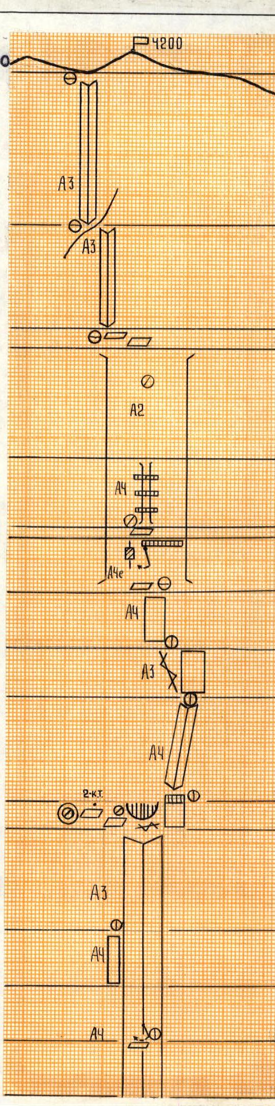
Profile of the SE wall of summit 4200 m. View from the right.
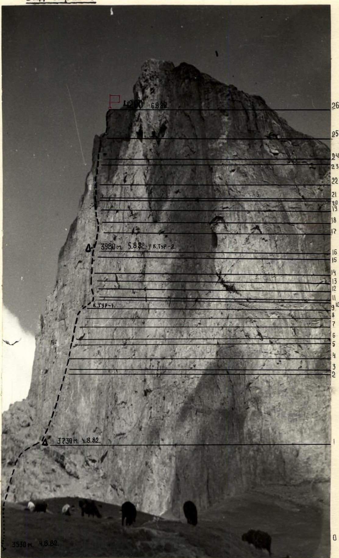 Photo-2
Panorama of the area.
 Photo-3
Brief Overview of the Climbing Area
The summit 4200 m (according to cartographic materials, 3778 m) is located in the Gissar Range, in the southeastern spurs of the Khosilot peak, in close proximity to the popular climbing area — Zamin Karor.
The southeast wall of summit 4200 m is a virtually sheer rock face. In its middle part, the wall has a bend, changing its orientation from SE to SSE.
The rocks are dolomites; in the middle part of the wall, there is an outcrop of schist. The rock fractures are oriented downwards, which complicates the ascent.
The height difference of the wall is 600–700 m, with a length of 1.5–2 km. The wall is sunlit for most of the day. During the ascent, the daytime temperature was above 30 °C. Its southern exposure poses challenging tasks for climbers regarding water supply, especially in the second half of summer. Water can be found in the upper part of the wall on this route and in the middle part of the section between the route on the SE wall and Kapitanov's route on the SSE wall.
The area is infrequently visited by climbers, likely due to the proximity of the identical and interesting Zamin Karor area.
Summit 4200 m is 5 hours' walk from the Margib village. The approach to the climbing object goes along the Dushanbe — Leninabad highway to the bridge over the Yaghnob River, then on foot or by car to Margib village — 4 km. Then, ascend along the Pindor River and, bypassing the massifs of the peaks:
- Zamin Karor
- Khosilot
through the Tagrich pass, to reach the southeast wall of summit 4200 m.
It is advisable to set up the base camp 1.5 km from the wall, near the springs.
Technical Photographs
-
Lower part of the upper rock belt. Photo on the left.
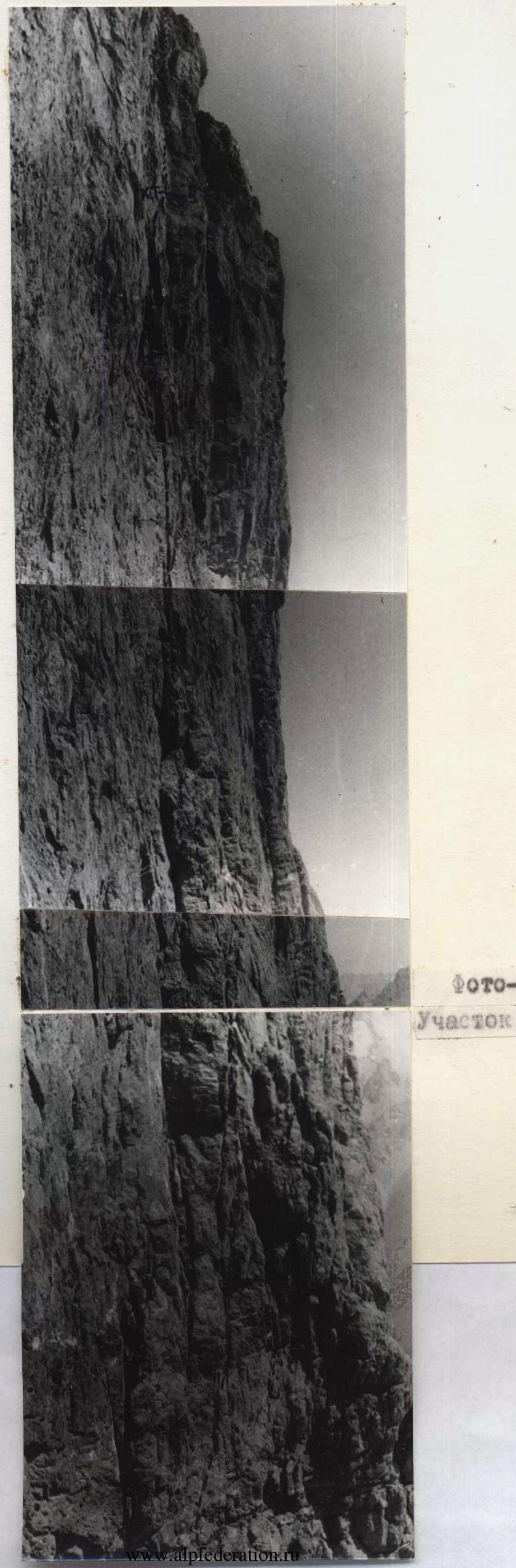 Photo-4 Section R1–R9
 -
Upper part of the upper rock belt. Photo on the right.
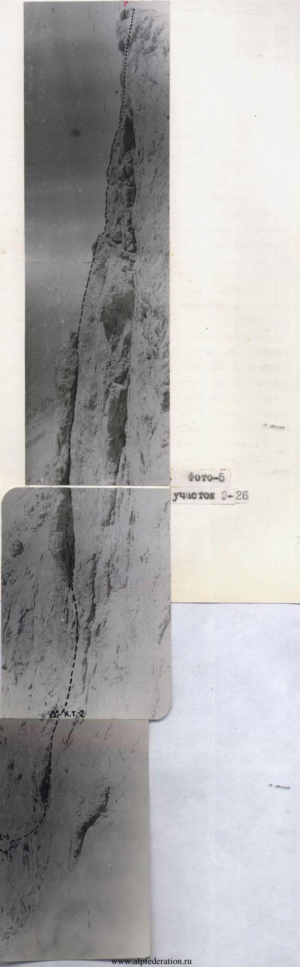 Photo-5 Section R9–R26
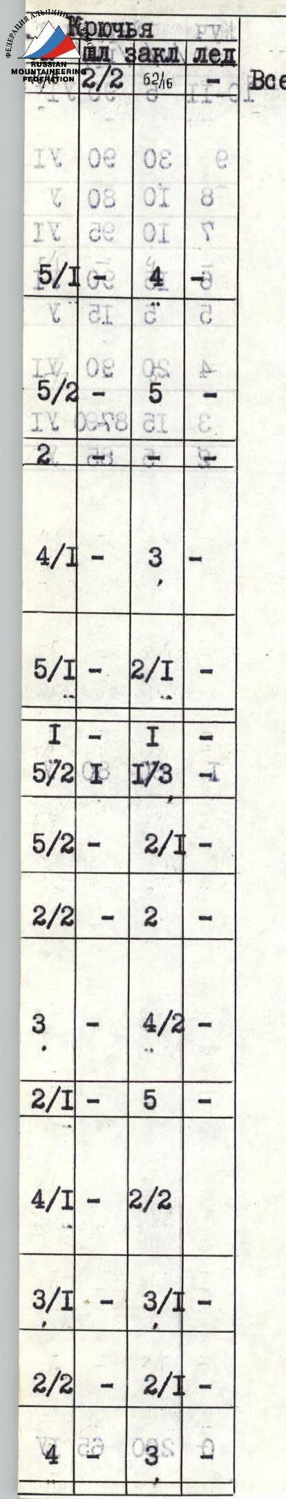 |  |  |
|---|
| Section | Length (m) | Steepness (°) | Difficulty category |
|---|---|---|---|
| R10–R11 | 5 | 90 | 4 |
| R9 | 30 | 90 | 6 |
| R8 | 10 | 80 | 5 |
| R7 | 10 | 95 | 6 |
| R6 | 15 | 90 | 6 |
| R5 | 5 | 75 | 5 |
| R4 | 20 | 90 | 6 |
| R3 | 15 | 87–90 | 6 |
| R2 | 5 | 85 | 5 |
| R0 | 200 | 65 | 4 |
| R25–R26 | 60 | 70 | 5 |
| R24 | 40 | 80 | 5 |
| R23 | 10 | 60 | 4 |
| R22 | 40 | 80 | 6 |
| R21 | 30 | 90–100 | 6 |
| R20 | 5 | 65 | 5 |
| R19 | 20 | 90 | 6 |
| R18 | 20 | 90 | 6 |
| R17 | 20 | 80 | 5 |
| R16 | 40 | 90 | 6 |
| R15 | 10 | 85 | 5 |
| R14 | 40 | 80 | 5 |
| R13 | 20 | 85 | 6 |
| R12 | 20 | 90 | 6 |
| R11 | 20 | 85 | 5 |
Route Description by Sections
Section R0–R1. The route begins at the lowest part of the wall, in its central part (photo – 3). The section is a mix of rock walls (3–5 m high) and sloping ledges. Overnight stay under an overhanging wall on a convenient ledge 15 m to the right of the route on a rock ridge. 200 m, 65°, 4th difficulty category.
Section R1–R2. Ascend via the right part of the internal corner to a horizontal ledge measuring 0.3 × 1 m. There is a possibility for good belaying and receiving a partner. 60 m, 80°, 5th difficulty category.
Section R2–R3. Represents an 85° narrow cleft, bounded below by a discontinuous sloping ledge 0.10 m wide and steeply rising to the right along sheer rocks. Climbing is very tense due to the difficulty of organizing reliable belays. There are very few places for intermediate belay points. The rocks are composed of quartzite schist; pitons do not go in because the quartzite shatters under the hammer blow. 5 m, 85°, 5th difficulty category.
Section R3–R4. After a narrow 10 cm ledge, the wall becomes sheer; there are no cracks, and the relief is extremely difficult, with very small hand and footholds. Three pitons need to be hammered in. 15 m, 87–90°, 6th difficulty category.
Section R4–R5. The wall leads to a sheer internal corner formed by a large chip and the wall. Climbing is extremely difficult. In the middle part, the corner overhangs. 20 m, 90°, 6th difficulty category.
Section R5–R6. The steepness of the corner decreases somewhat. Relief appears. The corner leads to the upper part of a large chip, where reliable belaying can be organized through a выступ, and a partner can be received. 5 m, 75°, 5th difficulty category.
Section R6–R7. Sheer wall with minimal handholds. Complex climbing makes it very difficult to organize intermediate belays. Significant psychological load on the first climber. The wall leads to a small sloping ledge under a cornice. 15 m, 90°, 6th difficulty category.
Section R7–R8. The cornice is overcome on the right via a narrow, overhanging cleft formed by a small chip. 10 m, 95°, 6th difficulty category.
Section R8–R9. Via the right part of a steep internal corner — 10 m ascent to a convenient horizontal ledge 0.5 m wide. Possible overnight stay location. 1st control point. 10 m, 80°, 5th difficulty category.
Section R9–R10. From the ledge, a "psychological" traverse along a vertical wall to the right to a rock ridge. Then, ascend along an overhanging wall to a gray sloping slab. Climbing is extremely difficult. At the end of the section, a sitting overnight stay for 4 people is possible. 30 m, 90°, 6th difficulty category.
Section R10–R11. From the right part of the slab, a large internal corner ascends directly upwards. The entrance to the corner is via a steep wall. 5 m, 90°, 6th difficulty category.
Section R11–R12. Ascend along a smoothed internal corner to a narrow ledge. Climbing is complex. 20 m, 85°, 5th difficulty category.
Section R12–R13. Sheer internal corner. It is not possible to pass through the center. A 5-meter pendulum to the left side of the corner is necessary. Artificial climbing aids (ITC) are required. 20 m, 90°, 6th difficulty category.
Section R13–R14. Cross over the edge of the corner to the left onto a smooth slab. There is nowhere to place pitons. Very tense free climbing on the verge of a fall. 20 m, 85°, 6th difficulty category.
Section R14–R15. Inclined internal corner, iced in the middle part, leads under a cornice. 40 m, 80°, 5th difficulty category.
Section R15–R16. Traverse under the cornice to the left, to the left part of the "cross" onto a ledge. Overnight stay location on a series of small ledges. After two hours of work, places for sitting overnight stays are prepared for all participants. These are ledges measuring 0.4 × 1.2 m. Water is available in the second half of the day. Second control point. 10 m, 85°, 5th difficulty category.
Section R16–R17–R18. From the overnight stay, a "psychological" traverse to the right. A 10-meter cleft is passed with free climbing and leads under a cornice, which is very difficult to overcome. Then, an inclined internal corner — a slab — leads to an absolutely smooth vertical wall. Departure via a 20-meter traverse to the left along a 10 cm flake. 40 m, 90°, 6th difficulty category, and 20 m, 80°, 5th difficulty category.
Section R18–R19. Departure to the left and upwards. Rocks are heavily destroyed. Movement is extremely cautious. Exit to the base of a chimney. 20 m, 90°, 6th difficulty category.
Section R19–R20. Iced chimney, overhanging in the middle part, with walls smoothed. The chimney cannot be climbed "head-on." A 5-meter pendulum to the left wall to a cleft. The cleft is passed using ITC. 20 m, 90°, 6th difficulty category.
Section R20–R21. From the cleft, ascend along a monolithic wall to a ledge convenient for belaying. 5 m, 65°, 5th difficulty category.
Section R21–R23. The chimney narrows to 1.5 m. The section is passed using chimney technique in a strong stretch. Rocks are monolithic but smoothed. Climbing is extremely difficult. Three overhangs need to be overcome. 30 m, 90–100°, 6th difficulty category, and 40 m, 80°, 6th difficulty category.
Section R23–R25. Approach along a series of ledges to a sheer internal corner. 10 m, 60°, 4th difficulty category; 20 m, 80°, 5th difficulty category; 20 m, 90°, 6th difficulty category.
Section R25–R26. Exit via the ridge to an internal corner and along it to the summit. 60 m, 70°, 5th difficulty category.