- Category of ascent — technical
- Area of ascent — Gissar Range
- Route of ascent — first ascent via the northern ridge of Khodzha Lokan peak — 4764 m
- Characteristics of ascent: height difference — 1000 m, average steepness — 57°, length of difficult sections — 430 m
- Pitons hammered: rock — 46, ice — 14
- Number of travel hours — 12 h
- Number of overnight stays — 1
- Ascent made by a group of instructors from "Varzob" alpine camp
- Surname, name, patronymic of the leader, participants and their qualification. Prisjazhnoi Vladimir Pavlovich, Candidate Master of Sports — leader Yanovitch Yuri Sergeyevich, Candidate Master of Sports — participant Getman Igor Samuilovich, Master of Sports — participant
- Team coach: Head of the training department of "Varzob" alpine camp, Sogrina E.
- Ascent made from July 1 to July 2, 1975
Brief description of the ascent object
The upper Siama area is well-known and popular in "Varzob" alpine camp, where routes range from 1B to 5B category of difficulty. The area is relatively accessible, with good, warm, and stable weather in the summer. The routes are predominantly rocky.
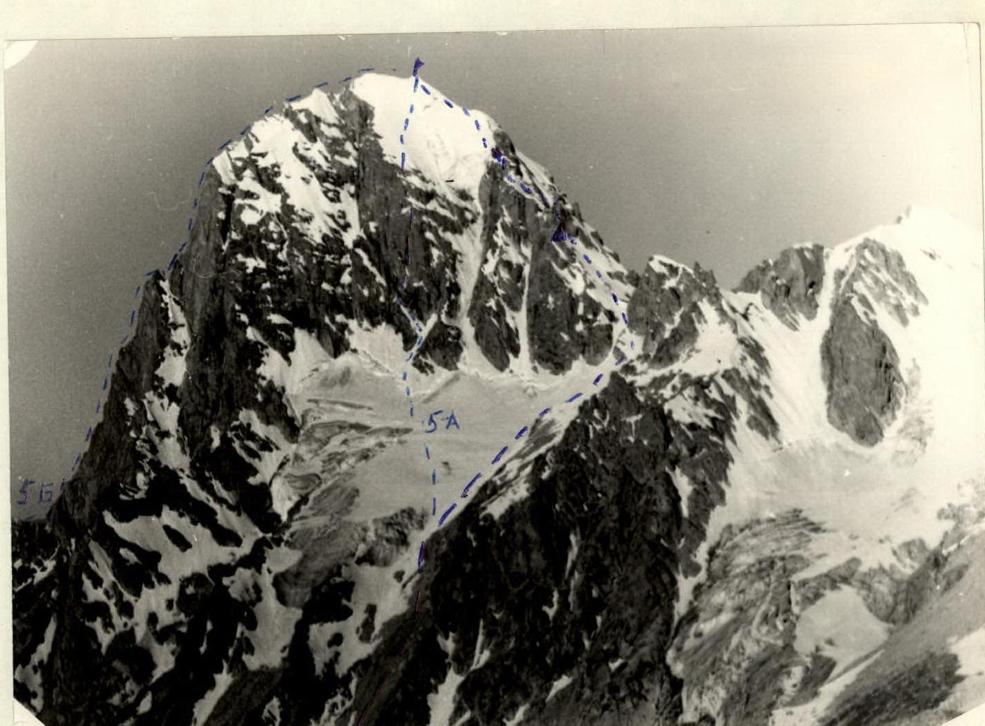
Khodja-Lokan is a southern spur of the Gissar Range. The highest point of the spur is the peak Mechta, 4764 m. Khodja-Lokan is the second highest point in the Siama area. From the Chotyrekh pass, Khodja-Lokan appears as a huge pyramid. A ridge extends north from the peak to the Mechta pass. This ridge was chosen for the ascent. The route was fully visible from the Chotyrekh pass.
A distinctive feature of the route is its combined nature. For such a "dry" area as "Varzob", such a route is of particular interest, allowing climbers to reinforce their training in snow and ice techniques.
There are three routes to the summit of Khodja Lokan:
- 5B via the South-Eastern edge — a rocky route;
- combined route via the eastern wall — 5A category of difficulty;
- combined route via the Western ridge — 4A category of difficulty.
The latter route is often used as a descent route from the peak.
Route description
First ascent to the peak Khodja Lokan via the Northern ridge (approximately 4B category of difficulty). On June 30, 1975, a group of instructors from "Varzob" alpine camp arrived at the Kadam-Tash stream under the peak Odessa for an overnight stay. The campsite was good. All routes, including the planned ascent to Khodja Lokan via the northern ridge, were clearly visible. Observers, three in total: Vasiliev V., Loshcul E., Vladimirova T., were able to maintain radio contact using a "Vitalka" radio station.
On July 1, 1975, at 5:00, the group left the campsite. They descended along the Kadam-Tash stream to the glacier located under the eastern wall of the peak. The descent along the stream took 30 minutes. Then they ascended to the base of the glacier via scree. They traversed the glacier straight up to a saddle on the northern ridge, to the left of the Mechta pass. A large gendarme separates the pass from the saddle, which is not necessary to traverse.
From this saddle, they proceeded along the ridge. To the right, steep slabs descend to the glacier; to the left, there is also a glacier. The rocks are moderately steep, piton belays are mandatory. The rocks are icy and snowy. They reached a ledge. It takes seven rope lengths to reach the ledge from the saddle on the left. There is a control cairn on the ledge, which cannot be bypassed.
From the ledge, there is a 3-meter descent to a small ledge that allows bypassing the first gendarme. The ledge occasionally disappears, and they had to proceed with piton belays. They moved up and to the right towards the second gendarme, into a gap. The bypass of the first gendarme took four rope lengths.
The second gendarme begins with difficult rocks. They ascended these rocks with piton belays for one rope length to reach the ridge. Further, they traversed a jagged ridge with alternating easy and difficult rocks — five rope lengths. Sometimes they had to hammer in pitons.
They approached the third, less pronounced gendarme. To the right, there are steep slabs; to the left, a vertical crevice. They ascended to the ridge via this vertical crevice — 6 meters. A wooden wedge was necessary here. The third gendarme was traversed relatively easily — four rope lengths. However, at the end, before the ice wall, the climbing was difficult (piton belays).
They reached the ice wall, which is the left side of a hanging glacier. At this narrow point, rockfalls from the glacier descend to the left, and steep, smooth slabs are on the right.
It was not possible to traverse the slabs. They decided to ascend the ice wall. They moved up and to the right on the ice with ice pitons, approximately 40 meters. The ice was up to 70° steep. Further, they ascended 10 meters up a sheer ice face. Here, ladders were necessary. After traversing these 10 meters, they reached a snowy slope, but the exit to it was icy, requiring step cutting. Further, along the snowy slope, they moved rightwards to the summit cairn.
On July 2, 1975, they descended via the Western ridge, following the 4A category of difficulty route. The ascent to the peak Khodja Lokan took 12 hours. The high tempo of the ascent was possible due to the small, qualified group.
The route is quite challenging and, in terms of technical difficulties, can be compared to the route to Khodja Lokan via the Eastern wall, 5B category of difficulty.
The group proposes to rate the traversed route as 4B category of difficulty.
Head of the training department of "Varzob" alpine camp, Sogrina E.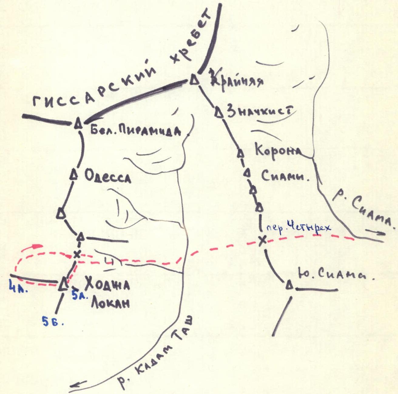
 Map of the area.
 Khodja Lokan. View from the Chotyrekh pass.
| Date | Section | Length of section (m) | Steepness (°) | Characteristics of terrain | Cat. diff. | Method of ascent and belay | Weather | Time of departure and belay | Pitons (rock) | Pitons (ice) | Bolts | Overnight stays |
|---|---|---|---|---|---|---|---|---|---|---|---|---|
| 01.07.1975 | R0–R1 | 280 | 50° | rocky, snowy, icy | 4 | free climbing, piton belay | good | 6:00 departure | 16 | — | — | — |
| R1–R2 | 160 | 45° | rocky | 3 | free climbing, piton belay | good | at 12:00 rest | 6 | — | — | yes | |
| R2–R3 | 40 | 80° | rocky | 5 | difficult climbing, piton belay | good | 12 hours of travel | 8 | — | — | — | |
| R3–R4 | 200 | 45° | rocky | 3 | free climbing, piton belay | good | — | 6 | — | — | — | |
| R4–R5 | 6 | 85° | rocky | 5 | difficult rocks with ladders | good | — | 4 | — | — | — | |
| R5–R6 | 160 | 15° | rocky | 2 | free climbing, simultaneous | good | — | — | — | — | — | |
| R6–R7 | 40 | 65° | rocky | 4 | average climbing, piton belay | good | — | 6 | — | — | yes | |
| R7–R8 | 40 | 70° | ice | 5 | difficult climbing, piton belay | good | — | — | 6 | — | — | |
| R8–R9 | 10 | 90° | ice | 5 | very difficult, piton belay, ladders | good | — | — | 6 | — | — | |
| R9–R10 | 20 | 45° | ice | 4 | average climbing, piton belay | good | — | — | — | — | yes | |
| R10–R11 | 200 | 40° | snowy | 3 | free climbing | good | — | — | — | — | yes | |
| 02.07.1975 | Descent via the route | — | — | 4A cat. diff. | — | — | — | — | — | — | — | — |
| 1975 | Group leader | — | — | — | — | — | — | (Prisjazhnoi V.) | — | — | — | — |
| Coach | — | — | — | — | — | — | (Sogrina E.) | — | — | — | — |