Compiled by: M. Levin, A. Praхов 1st shooting point of photo 1 and so on.
PHOTO 1
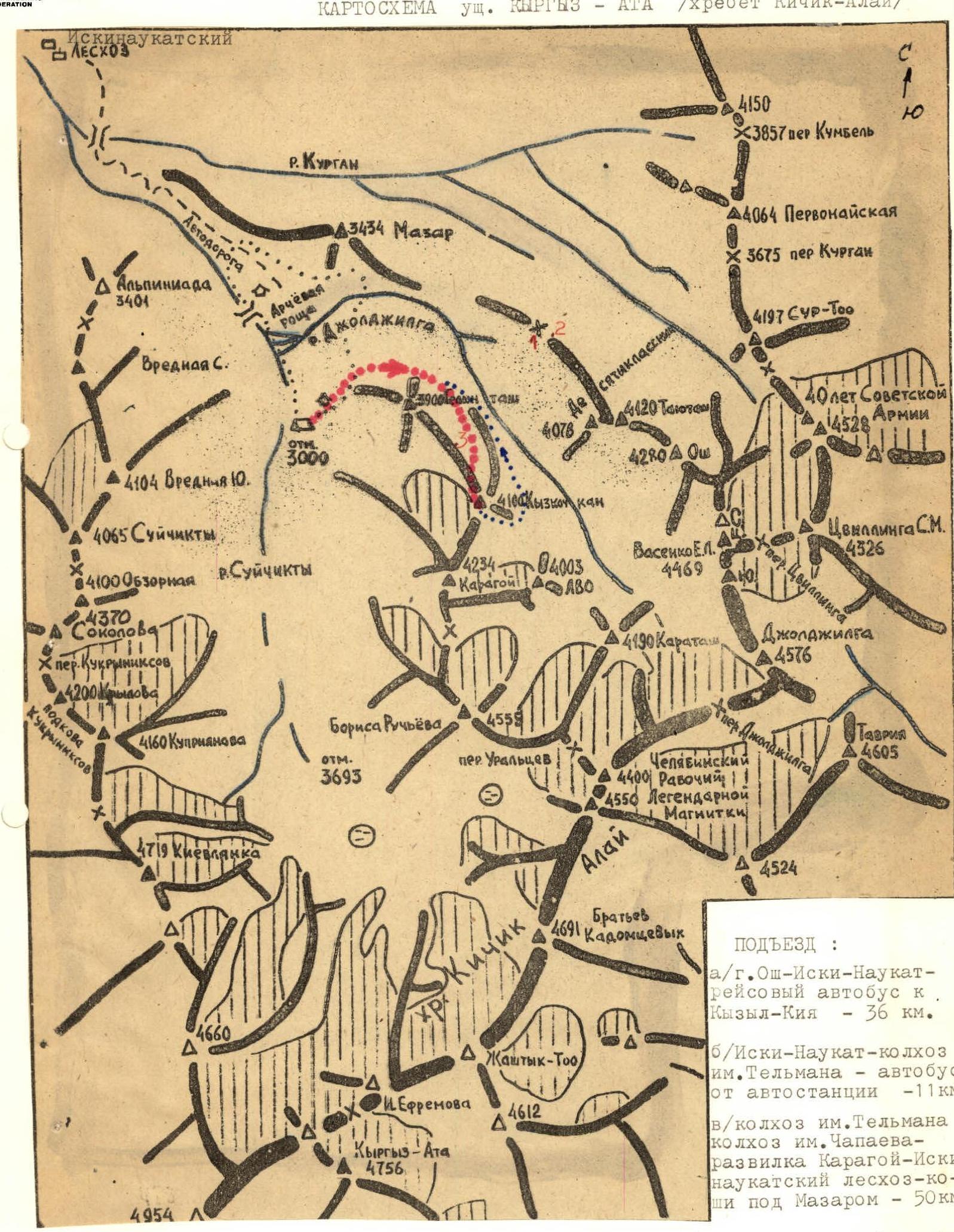
MAP OF KYRGYZ-ATA GORGE (Kichik-Alay range) Iski-Naukat LESKHOZ R. Kurgan Highway Alpinada 3401 Harmful S. Arch Forest 3434 Maazar R. Jolajilga elevation 3000 4104 Vrednaya 10 4065 Suichikty 4100 Overview R. Suichikty 4370 Osokovaya Kukrniksov pass 4200 Krylova Kukrniksov's Horseshoe 4160 Kupriyanova Tenth Grader 3900 Telman 4078 4100 Kyzkoikan 4120 Tashtum 4280 Osh 4150 3857 Kumbel pass S 4064 Pervomayskaya 3675 Kurgan pass 4197 SUR-ToO 40 Years of Soviet Army 4528 Dkh, Zwilling S.M. 4326 Zwilling pass Joldjilga 4576 4234 Karagoy 4003 AVO Vasenko E.L. 4469 4190 Karatash Boris Ruchyov's 4559 elevation 3693 Uraltsev pass Kichik-Alay range Joldjilga pass Chelyabinsk 4400 Worker 4550 Legendary Magnitka Brothers Kadomtsev's 4691 Jashtyk-ToO Efremova 4612 Kyrgyz-Ata 4756 4954 Alay Tavriya 4605
APPROACH: a/ Osh–Iski-Naukat highway — scheduled bus to Kyzyl-Kiya — 36 km. b/ Iski-Naukat — Telman collective farm — bus from bus station — 11 km. c/ Telman collective farm — Chapayev collective farm — Karagoy–Iski-Naukat forestry — koshi under Maazar — 50 km.
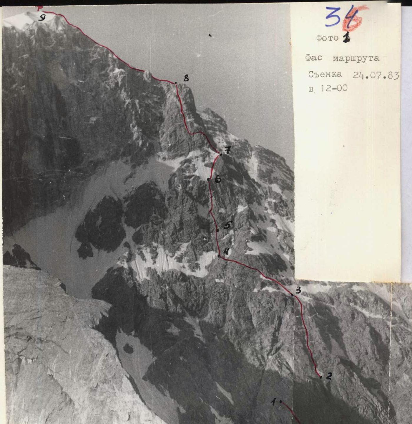
PHOTO 2 Route face Shooting on July 24, 1983 at 12:00 Yakovlev N.K. — Order 28/III-83. Askarov S.N. — Order 560, 235, 59°, 36 pitons, 5 hooks, 8 hr. pass V-VI
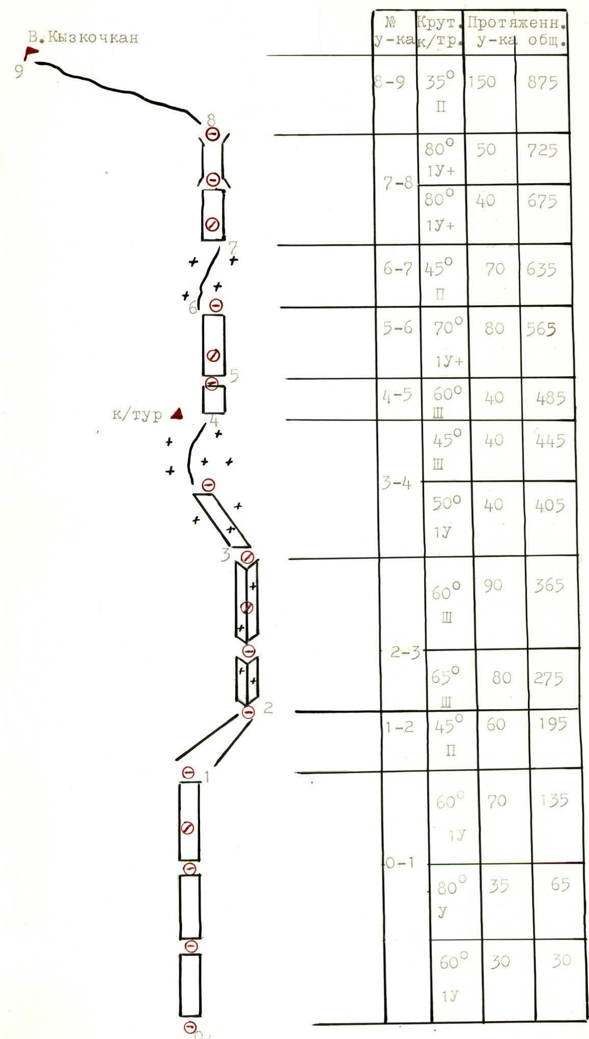

E. Kyzkochan ROUTE SCHEME IN UIAA SYMBOLS
| № | Steepness | Length | diff. cat. | pitch (m) | total (m) |
|---|---|---|---|---|---|
| R8–R9 | 35° | 2 | 150 | 875 | |
| R7–R8 | 80° | 1 | 50 | 725 | |
| 80° | 1 | 40 | 675 | ||
| R6–R7 | 45° | 2 | 70 | 635 | |
| R5–R6 | 70° | 1 | 80 | 565 | |
| R4–R5 | 60° | 3 | 40 | 485 | |
| 45° | 3 | 40 | 445 | ||
| R3–R4 | 50° | 1 | 40 | 405 | |
| 60° | 3 | 90 | 365 | ||
| R2–R3 | 65° | 3 | 80 | 275 | |
| R1–R2 | 45° | 2 | 60 | 195 | |
| R0–R1 | 60° | 1 | 70 | 135 | |
| 80° | 5 | 35 | 65 | ||
| 60° | 1 | 30 | 30 | ||
| rock/ice protection |
TABLE OF MAIN ROUTE CHARACTERISTICS Table 1
| Date | № | Avg. | Length | Character | diff. cat. | Relief condition | Weather | Pitons |
|---|---|---|---|---|---|---|---|---|
| Time | pitch | steep. | m. | relief | conditions | hooks, pitons | ||
| July 28, 1983 | R0–R1 | 75° | 135 | Wall | 1 | Monolithic rocks, hard climbing with few holds. | +8° | 12, 2 |
| from 7:00 to 14:45 | Clear | |||||||
| R1–R2 | 45° | 60 | Scree gully | 2 | Medium scree, right through the gully. Simultaneously | — | —, — | |
| R2–R3 | 65° | 170 | Internal corners | 3 | Destroyed rocks with overlapping structure, some places with ice. May be exposed to rockfall in the afternoon. | — | —, 5 | |
| R3–R4 | 50° | 80 | Inclined shelf and rock ascent | 1 | Snow-covered rocks, climbing is difficult. At the end of the section, a control cairn on the shelf. | — | —, 2 | |
| R4–R5 | 50° | 40 | Wall | 3 | Rocks of medium climbing difficulty, sufficient holds | — | 2, 1 | |
| R5–R6 | 70° | 80 | Wall | 1 | Vertical, smooth monolithic slabs. Holds are lateral. | 9, 1 | ||
| R6–R7 | 45° | 70 | Slope | 2 | Dense snow. Depending on the time, there may be ice under the snow. | — | —, — | |
| R7–R8 | 80° | 90 | Red wall, chimney | 1 | Destroyed blocks. Few places for pitons (better with wedges). Move on a double rope. | +10° | 6, 1 | |
| R8–R9 | 35° | 150 | Ridge | 2 | Large scree. Simultaneously | — | —, — | |
| TOTAL | 36, 5 |
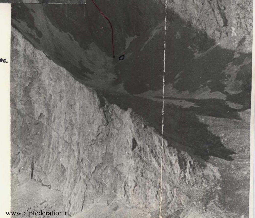
DESCENT: towards E. LVO, into Jolajilga gorge.
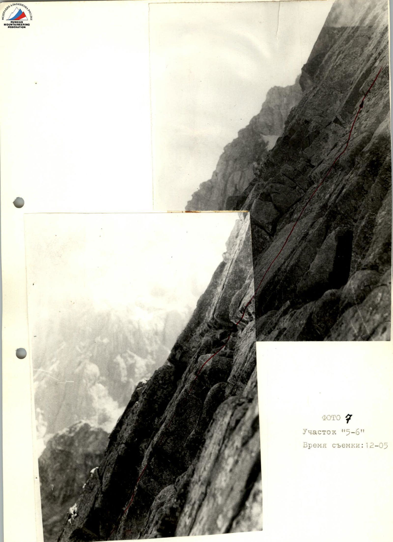
PHOTO 7 Section «5–6» Shooting time: 12:05
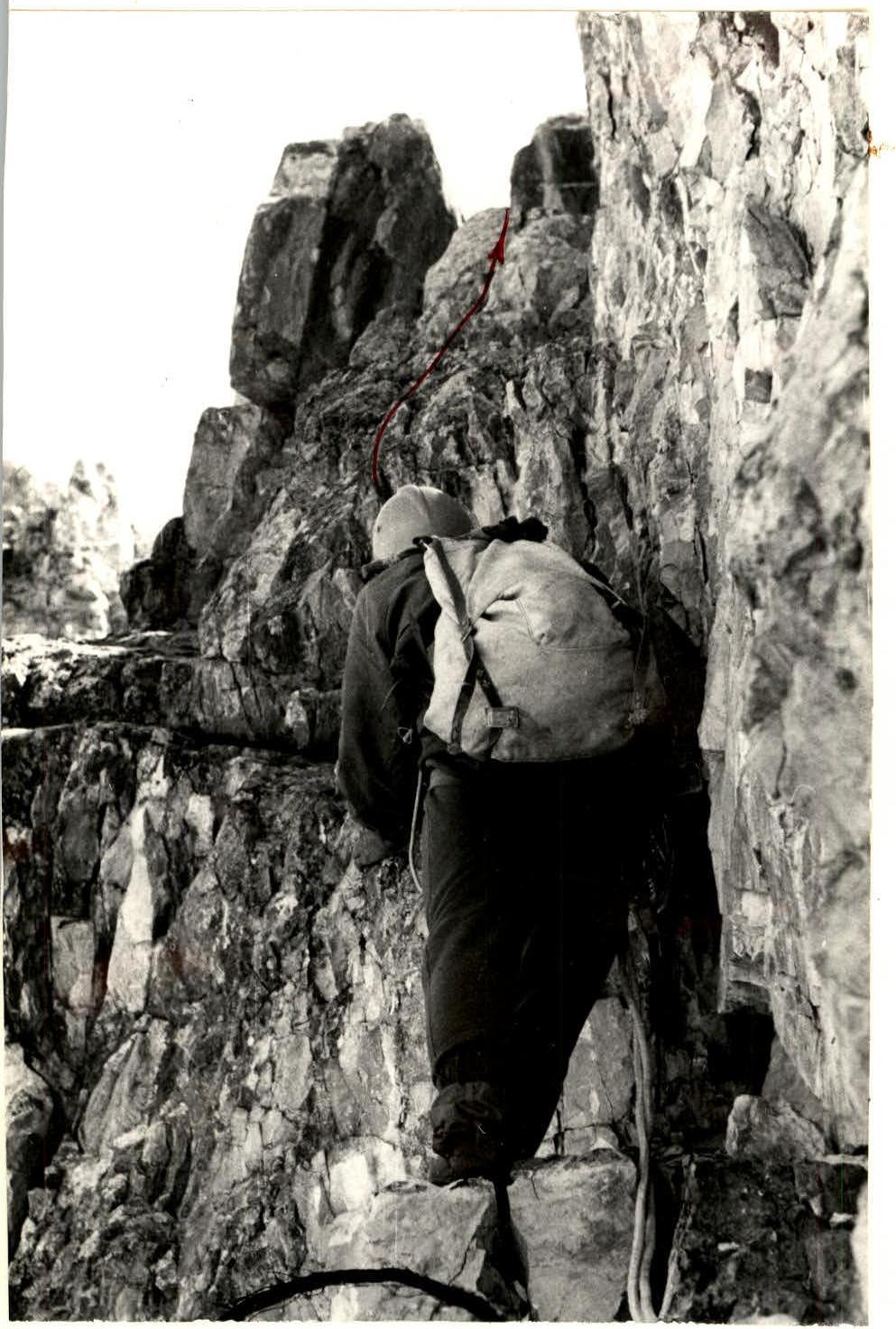
PHOTO 8 Section «7–8» Shooting time: 12:45


