Ascent Passport № 20
- Ascent class — technically challenging
- Ascent area — Alay ridge, northern spur
- Peak, its height, ascent route — peak 5100 m via the counterfort of the North face
- Proposed category — 5B
- Route characteristics:
- height difference — 1200 m
- height difference of the wall section — 1100 m
- length of sections: IV difficulty category — 855 m, V difficulty category — 805 m, VI difficulty category — 90 m
- average steepness of the wall section — 64°
- Pitons driven: for belay — 84 (rock), 18 (ice), 2 (bolts); for artificial climbing aids — 18 (rock), 2 (ice), — (bolts) placed chocks — 32; for artificial climbing aids — 10
- Number of climbing hours — 36.5
- Number of overnight stays — 2, both semi-reclining on ice
- Full name of the leader, participants, and their qualification: Beylin Yuri Iosifovich — CMS — leader Moshnikov Anatoly Ivanovich — MS — participant Barulin Boris Alexandrovich — MS — participant Varov Viktor Ivanovich — CMS — participant Parshin Vladimir Sergeevich — CMS — participant Subbotin Vladimir Nikolaevich — CMS — participant Sazanov Viktor Vasilyevich — CMS — participant
- Team coach — ICMS Gorenchuk Yu.F.
- Date of departure on the route — July 20, 1981, date of return to the base camp — July 24, 1981
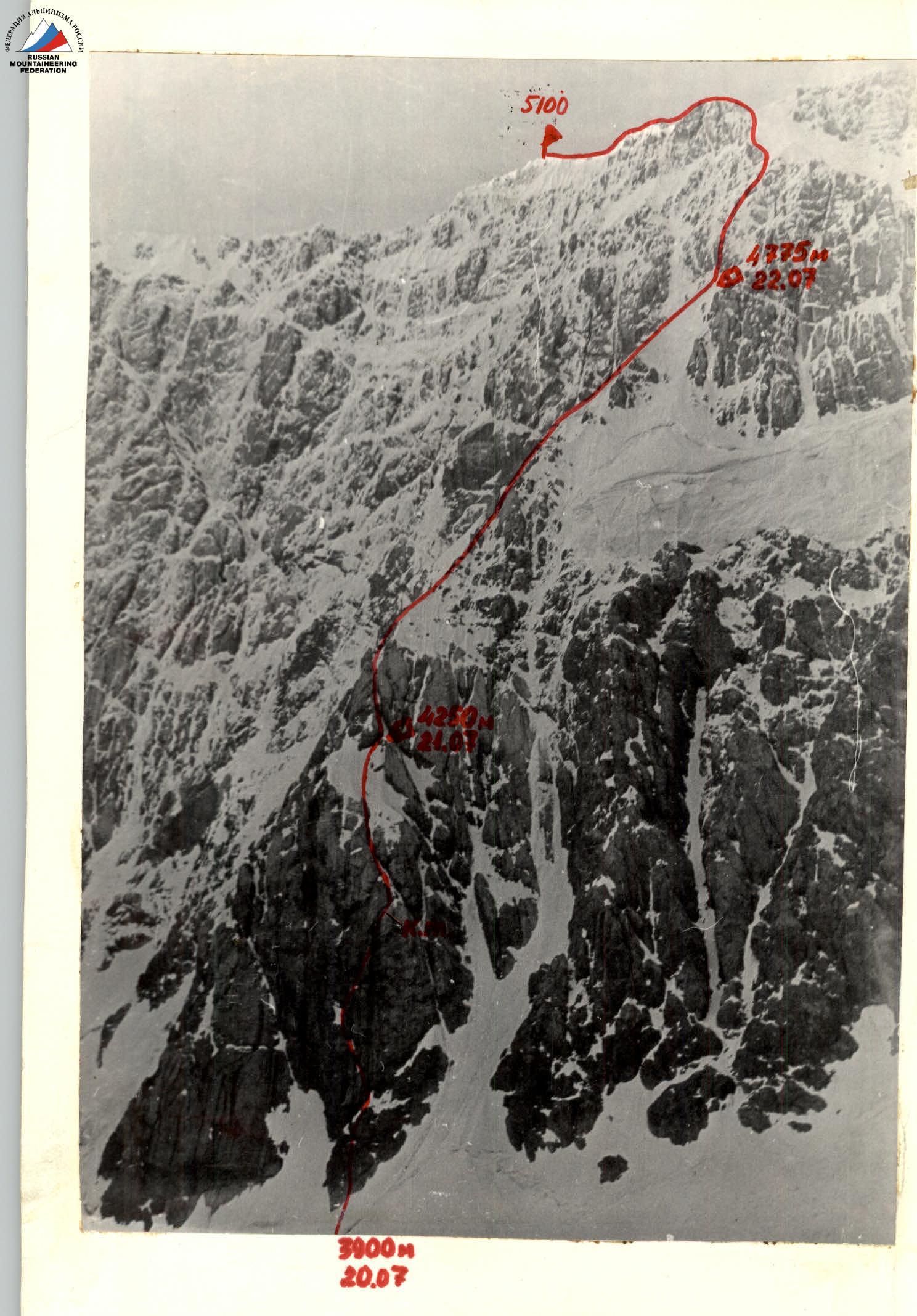
General view of the route — first ascent of peak 5100 m via the counterfort of the North face.
Table of main characteristics of the ascent route to peak 5100 via the counterfort of the North face (5B orientation)
Route length — 1750 m Height difference — 1200 m Average steepness of the wall section of the route — 64° Height difference of the wall section — 1100 m
| Date | Section designation | Average steepness in degrees | Length in m | Terrain character | Difficulty | Condition | Method of overcoming and belay | Exit time | Stops for bivouac per day | Climbing hours | Rock pitons | Chocks | Ice screws | Overnight stay | Weather conditions |
|---|---|---|---|---|---|---|---|---|---|---|---|---|---|---|---|
| 20.07.1981 | R0–R1 | 50 | 80 | Ice-snow slope with bergschrund | 4 | Firm snow, after bergschrund – ice under a thin layer of snow | Alternating, crampons, in bergschrund – artificial climbing aids | 2 | 2 | — | — | ||||
| R1–R2 | 70 | 40 | Wall | 5 | Destroyed needle-like rocks | Free climbing with piton belay | 6 | 2 | — | — | |||||
| R2–R3 | 75 | 40 | Wide internal angle | 5 | Flowstone | Free climbing with piton belay | 5 | 3 | — | — | |||||
| R3–R4 | 90 | 30 | Wide internal angle, overhanging wall | 6 | Destroyed rocks, flowstone | Free climbing; use of artificial climbing aids | 10 | 3 | — | — | |||||
| R4–R5 | 90 | 45 | Implicit internal angle, cornice | 6 | Cornice destroyed, ice in internal angle | Free climbing; use of artificial climbing aids under cornice | 16 | 4 | — | — | |||||
| R5–R6 | 45 | 15 | Diagonal ledge | 4 | Snow-covered | Alternating, pitons | 2 | — | — | — | |||||
| R6–R7 | 50 | 60 | Ice couloir | 5 | Thin layer of snow on ice | Alternating, crampons | 2 | — | 3 | — | |||||
| R7–R8 | 50 | 100 | Ice-snow slope with rock outcrops | 5 | Thin layer of snow on ice | Alternating, crampons | 3 | — | 3 | — | |||||
| R8–R9 (processing) | 65 | 40 | Wide ice couloir, blocked by overhanging boulder (bypass – wall) | 5 | Thin layer of snow on ice, monolithic wall | Alternating, pitons | 3 | — | 2 | — | |||||
| R9–R10 (processing) | 75 | 40 | Wide ice chimney | 5 | Ice at the bottom, monolithic walls | Free climbing, crampons | 8:00 | 19:30 (processing until 21:30) | 4 | 13.5 | 1 | 1 | Semi-reclining, on ice | Overcast | |
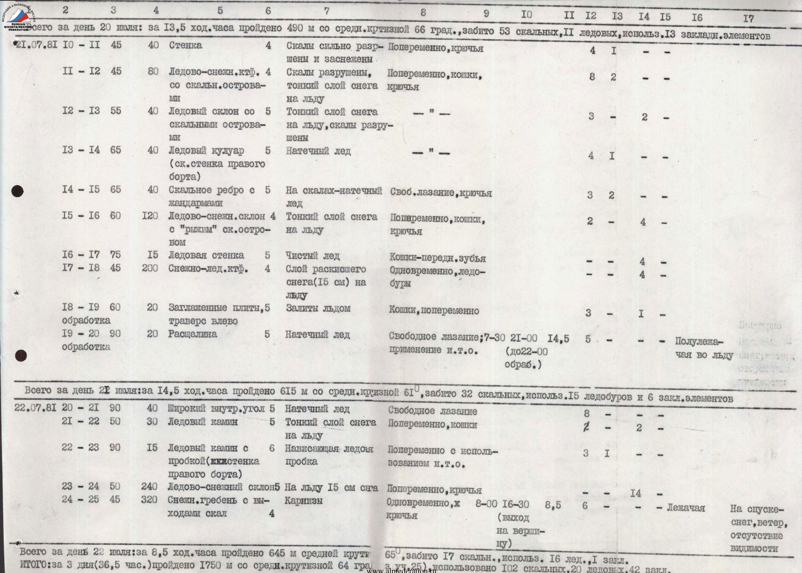
| Total for July 20: in 13.5 climbing hours, 490 m traversed with an average steepness of 66°, 53 rock pitons, 11 ice screws used, 13 chocks placed | |||||||||||||||
| 21.07.1981 | R10–R11 | 45 | 40 | Wall | 4 | Rocks heavily destroyed and snow-covered | Alternating, pitons | 4 | 1 | — | — | ||||
| R11–R12 | 45 | 80 | Ice-snow counterfort with rock outcrops | 4 | Rocks destroyed, thin layer of snow on ice | Alternating, crampons, pitons | 8 | 2 | — | — | |||||
| R12–R13 | 55 | 40 | Ice slope with rock outcrops | 5 | Thin layer of snow on ice, rocks destroyed | — | 3 | — | 2 | — | |||||
| R13–R14 | 65 | 40 | Ice couloir (rock wall on the right side) | 5 | Flowstone | — | 4 | 1 | — | — | |||||
| R14–R15 | 65 | 40 | Rock ridge with gendarmes | 5 | Flowstone on rocks | Free climbing, pitons | 3 | 2 | — | — | |||||
| R15–R16 | 60 | 120 | Ice-snow slope with "rusty" rock outcrop | 4 | Thin layer of snow on ice | Alternating, crampons, pitons | 2 | — | 4 | — | |||||
| R16–R17 | 75 | 15 | Ice wall | 5 | Pure ice | Crampons – front points | — | — | 4 | — | |||||
| R17–R18 | 45 | 200 | Snow-ice counterfort | 4 | Layer of wet snow (15 cm) on ice | Simultaneous, ice screws | — | — | 4 | — | |||||
| R18–R19 (processing) | 60 | 20 | Smoothed slabs, traverse left | 5 | Ice-covered | Crampons, alternating | 3 | — | 1 | — | |||||
| R19–R20 (processing) | 90 | 20 | Crevice | 5 | Flowstone | Free climbing; use of artificial climbing aids | 7:30 | 21:00 (until 22:00 processing) | 14.5 | 5 | — | — | Semi-reclining on ice | Snow, wind | |
| Total for July 21: in 14.5 climbing hours, 615 m traversed with an average steepness of 61°, 32 rock pitons, 15 ice screws used, 6 chocks placed | |||||||||||||||
| 22.07.1981 | R20–R21 | 90 | 40 | Wide internal angle | 5 | Flowstone | Free climbing | 8 | — | — | — | ||||
| R21–R22 | 50 | 30 | Ice chimney | 5 | Thin layer of snow on ice | Alternating, crampons | 2 | — | 2 | — | |||||
| R22–R23 | 90 | 15 | Ice chimney with a plug (rock wall on the right side) | 6 | Overhanging ice plug | Alternating with use of artificial climbing aids | 3 | 1 | — | — | |||||
| R23–R24 | 50 | 240 | Ice-snow slope | 5 | 15 cm of snow on ice | Alternating, pitons | — | — | 14 | — | Reclining | On descent – snow, wind, lack of visibility | |||
| R24–R25 | 45 | 320 | Snow ridge with rock outcrops | 4 | Cornices | Simultaneous, pitons | 8:00 | 16:30 (exit to the summit) | 8.5 | 6 | — | — | |||
| Total for July 22: in 8.5 climbing hours, 645 m traversed with an average steepness of 65°, 17 rock pitons, 16 ice screws used, 1 chock placed | |||||||||||||||
| TOTAL: in 3 days (36.5 hours), 1750 m traversed with an average steepness of 64°, 102 rock pitons, 20 ice screws, 42 chocks used |
Order of route passage
(explanations for the table of main route characteristics)
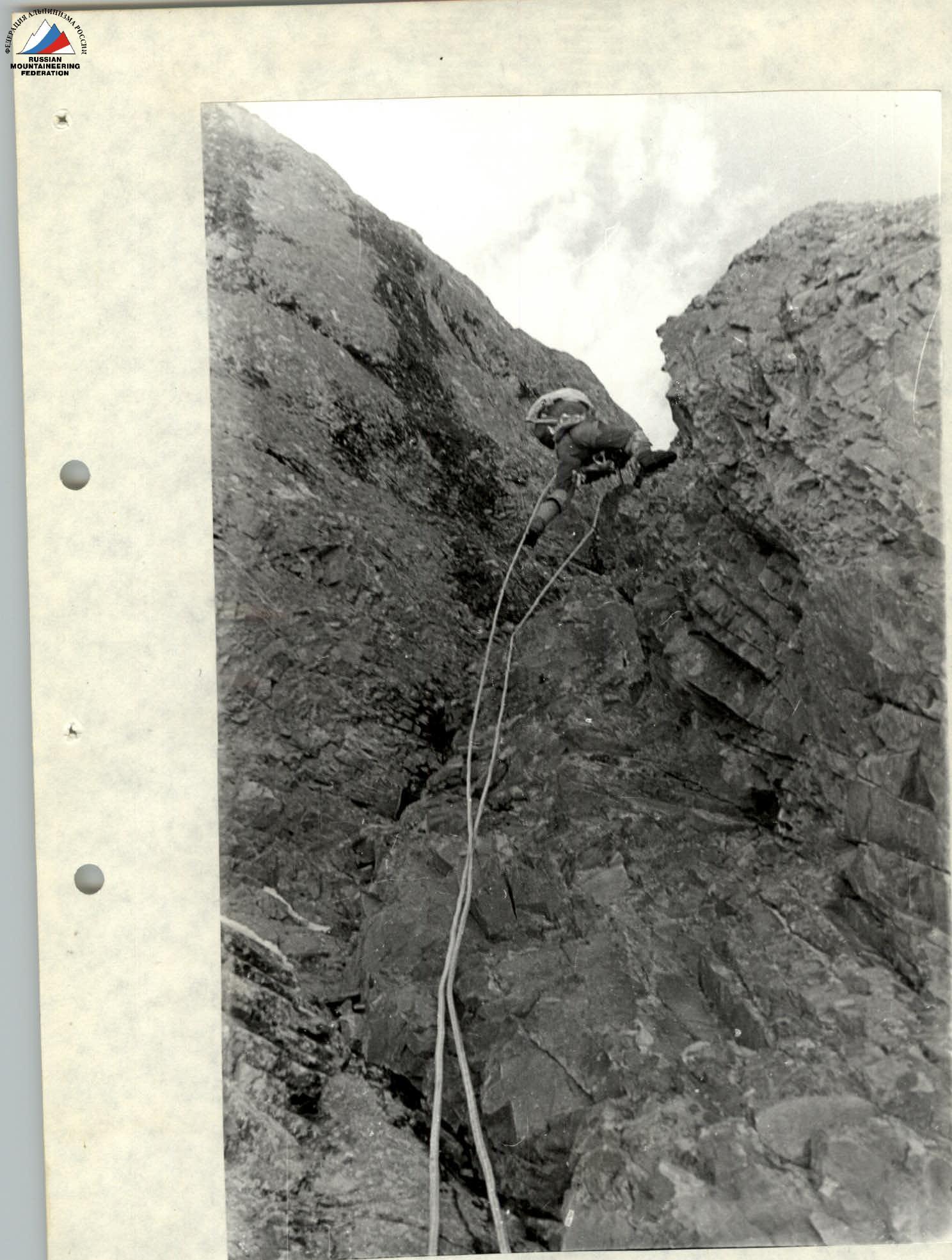
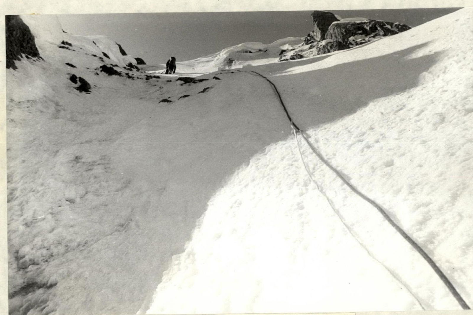
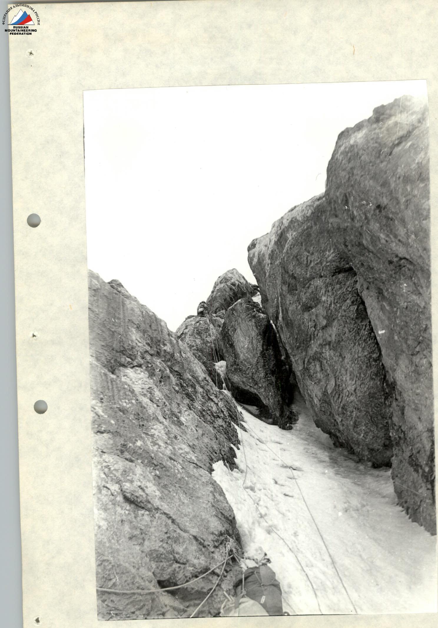
July 20. From the assault camp located on the last outlet of the left-bank moraine of the Nizhny Guamysh glacier to the route — 20 minutes walk. We approach the lowest part of the "paw" slightly to the left: in the couloir located to the right of the lower bastion, there are many traces of avalanches and pieces of ice that have fallen from the icefall. Today, the Beilin — Moshnikov team is working first. We approach the bergschrund via firm snow in crampons, which is overcome with the help of two ice axes stuck in the opposite wall. Along the ice slope, we approach the base of the rock "paw". The rocks are heavily destroyed, needle-like, and covered with flowstone. When we finish passing the first rope on the "paw", the rest of the group approaches the processed bergschrund from the assault camp. We pass three ropes through a system of wide internal angles and walls until we exit onto a narrow diagonal snow-covered ledge. The last two ropes are particularly difficult: the terrain is steep (several overhanging sections of 4–5 m), the rocks are destroyed, there is a lot of flowstone, and few cracks. Under the cornice, about five meters from the exit to the ledge, we hang a control cairn. After the ledge, we exit into an ice couloir onto a large ice-snow patch. We climb straight up to a rocky shoulder with a snow-ice overhang. Time is 19:30. Subbotin — Moshnikov go for further processing. The rest "dig in" into the ice, and within 1.5 hours, a relatively comfortable bivouac is ready. By 21:30, the processors return — they have traversed another 2 ropes along the ice couloir and a wide steep ice chimney.
July 21. At 7:30, the Sazanov — Parshin team is the first to go up via the fixed ropes. From the end of the processed section, via heavily snow-covered destroyed rocks, and then — a snow-ice counterfort with rock rises of 3–5 m — we exit to two markings on the gendarmes, well visible from below. Between them, an ice slope with destroyed rock outcrops introduces us to an ice couloir. Along the rocks on its right side, we climb up to exit onto a snow-covered ridge. The ridge, on which there are steep sections of 4–5 m, leads to an ice slope with a "rusty" rocky island in the middle. Through the island, we exit onto a snow-ice counterfort. Before exiting onto the counterfort, the ice slope turns into a 15-meter wall of pure ice. Crampons "Makalu" and ice hammers are very helpful. Further along the snow-ice counterfort, turning slightly left, we pass 5 ropes to the base of the upper bastion. It's time to prepare for the overnight stay. Again, we have to spend 2 hours cutting out a place for two tents in the ice. Parshin — Sazanov processed 20 m of complicated traverse left into a crevice under the upper bastion along ice-covered slabs and 20 m along a vertical crevice during this time.
July 22. At 8:00, the Varov — Moshnikov team goes up. The vertical crevice passed in the evening introduces us into a wide vertical internal angle filled with flowstone. We use ladders. The internal angle slightly "subsides", turning into an ice chimney closed by a plug. Along the rock wall on the right side of the chimney (again ladders), we exit onto an ice-snow slope. The loose snow layer, about 20 cm thick, lies on fairly steep ice, making it very difficult to carve out steps. Crampons quickly get clogged with snow. Progress slows down. By 15:00, we exit onto the western ridge of the summit, leave our backpacks on the saddle, and at 16:30, we are on the summit of peak 5100 m.
Until now, peak 5100 has not been conquered: Gorenchuk's group in 1977, on the descent from peak 5200, bypassed peak 5100 along its southern slopes, and S. Efimov's group in 1980 preferred to descend from peak 5200 through peak 5367 via the 4B category route.
We build a well-visible cairn and begin our descent towards peak 4850. At 20:00–20:30, we stop for an overnight stay under the eastern ridge of peak 4850 on the saddle.
July 23. The weather deteriorates sharply in the morning: wet snow, wind, visibility 20 m. We decide to descend to the Control Geodetic Point in the Jalalyisu valley. The descent to the crampons at the river takes 3 hours 30 minutes. Here it's raining, but still warm.
July 24. By 15:00, we return to the base camp.
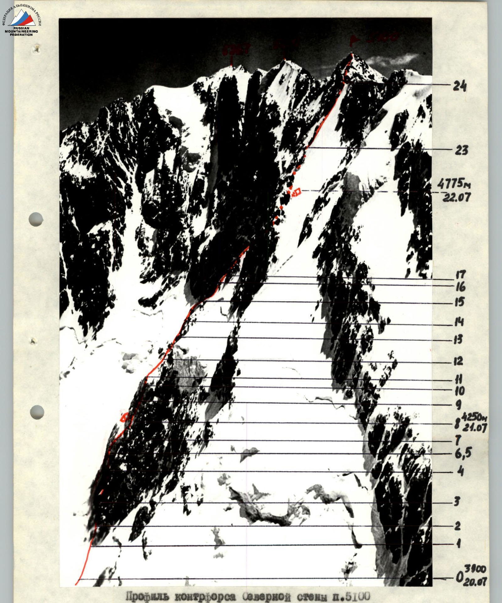
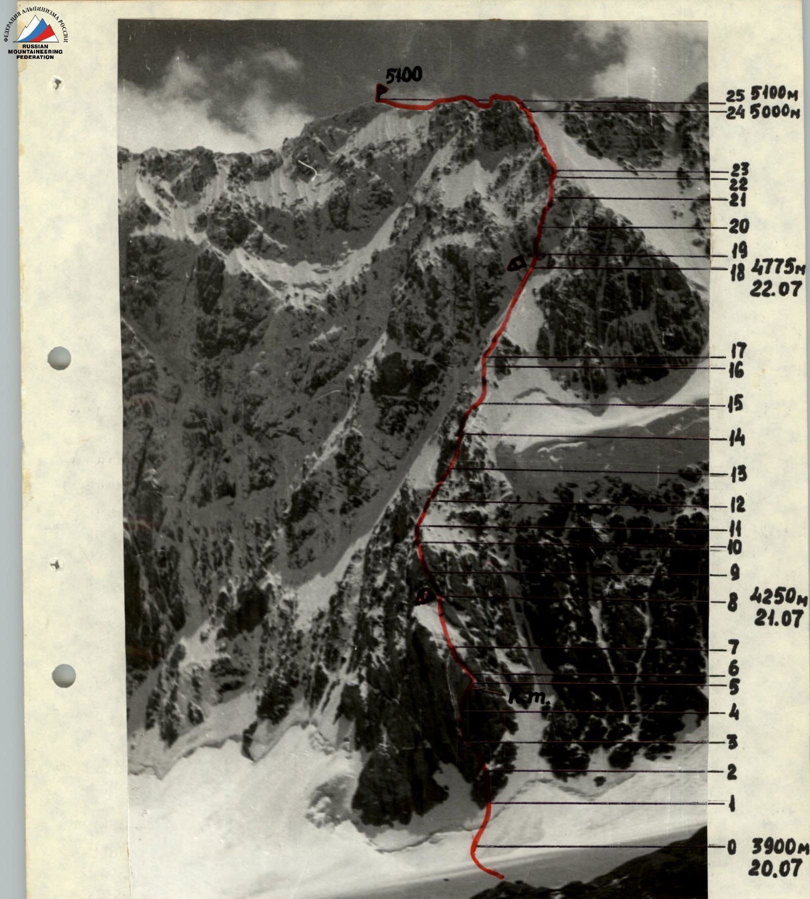
Profile of the counterfort of the North face of peak 5100
(snapshot taken from the eastern edge of peak 4850)
- ascent route
- . . . invisible part of the route
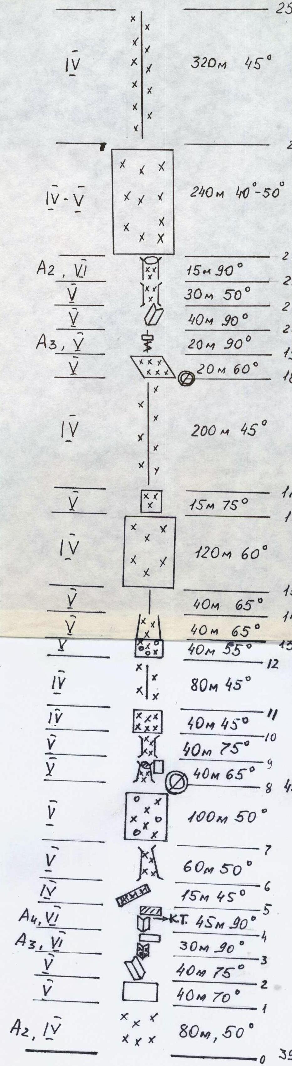
Route sketch in UIAA symbols
From R0 to R25 (3900–5100 m)
- R0–R1: A2, IV, 80 m, 50°
- R1–R2: V, 40 m, 70°
- R2–R3: V, 40 m, 75°
- R3–R4: A3, VI, 30 m, 90°
- R4–R5: A4, VI, К.Т. 45 m, 90°
- R5–R6: IV, 15 m, 45°
- R6–R7: V, 60 m, 50°
- R7–R8: V, 100 m, 50°
- R8–R9: V, 40 m, 65° (4250 m)
- R9–R10: V, 40 m, 75°
- R10–R11: IV, 40 m, 45°
- R11–R12: IV, 80 m, 45°
- R12–R13: V, 40 m, 55°
- R13–R14: V, 40 m, 65°
- R14–R15: V, 40 m, 65°
- R15–R16: IV, 120 m, 60°
- R16–R17: V, 15 m, 75°
- R17–R18: IV, 200 m, 45°
- R18–R19: V, 20 m, 60° (4775 m)
- R19–R20: A3, V, 20 m, 90°
- R20–R21: V, 40 m, 90°
- R21–R22: V, 30 m, 50°
- R22–R23: A2, VI, 15 m, 90°
- R23–R24: IV–V, 240 m, 40°–50° (5000 m)
- R24–R25: IV, 320 m, 45° (5100 m)