Ascent Passport
- Ascent class — co-technical;
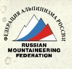
- Ascent area — Pamiro-Alai, Guamysh gorge;
- Peak, its height, ascent route — unnamed peak, 4300 m from the west, approximately 3A category of difficulty (first ascent)
- Category of difficulty — 3A
- Route characteristics: height difference — 500 m; length of sections with 3–4–5 categories of difficulty — 270 m; average steepness — 62°
- Pitons driven: rock — 9, ice — 4, chocks — 7.
- Number of climbing hours — 11 hours.
- Date of ascent and return: June 27, 1981

Group composition:
- Gorbunutin A.N. — leader, 1st sports category
- Korol M.N. — participant, 1st sports category
- Shcherbinin V.A. — participant, 1st sports category
- Savenkov N.A. — participant, 1st sports category
- Dusharina N.D. — participant, 1st sports category
Coach — Benkin V.S. — Master of Sports
Report compiled by: Gorbunutin A.N.
Kuibyshev Regional Council of DSO "Trud" 1981 
MAP OF THE ASCENT AREA
www.alpfederation.ru↗ 
Route description
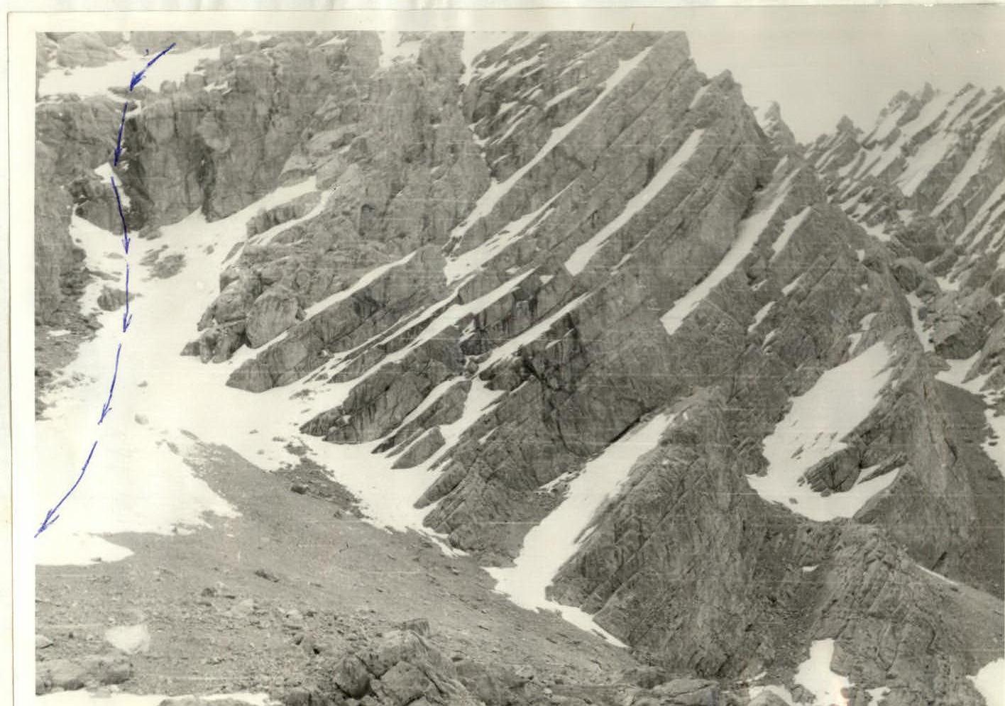
From the base camp located in the Guamyi gorge, opposite the cirque of glacier No.3, cross to the left bank of the Guglyi River. Downstream along the left bank of the river, reach the couloir exiting from the cirque of glacier No.4. Up the couloir to glacier No.4. Then, along the left side (in the direction of travel) of the glacier, approach peak 4300. The western slope of peak 4300.
Start the route from the ridge of the scree couloir, ending with a characteristic inclined patch. The ledge, when viewed from above, looks like a long channel going up to the right, starting from pass "Galbuka". Count "galbukas" starting from the first northern gap from peak 4300.
R0–R1 section — scree ledge going up to the right, covered with snow, sometimes with loose stones. Can be traversed parallel with a belay through belay anchors.
R1–R2 section — a crack goes up the slope of the R0–R1 section — complex climbing with piton belay. Sections with remelted ice are encountered.
R2–R3 section — a crack ending with small snow drifts, traversed with piton belay. R1–R2 and R2–R3 sections are assessed as "complex climbing" with piton belay.
R3–R4 section — scree couloir — easy rocks, not rockfall-prone.
R4–R5 section — a couloir narrowing into the steepest sections, turning into an internal corner of the rock. Complex climbing with piton belay.
R5–R6 section — a rock ledge going left, quite wide.
R6–R7 section — up to the left along the snow-covered slope; R8–R9, R7–R8 section — a snow-covered slope, ending with a rock wall turning into a groove with remelted ice. Intermittent passage, complex climbing with the use of piton belay; R9–R10 section — a ledge going up to the left, to the pre-summit ridge R10–R11 section — the pre-summit ridge, representing a snow-ice slope. In the lower part, it is traversed with piton belay.
Time taken to traverse the sections:
- Approach — 1 hour 30 minutes;
- R0–R1 section — 40 minutes;
- R1–R2 section — 30 minutes;
- R2–R3 section — 30 minutes;
- R3–R4 section — 1 hour;
- R4–R5 section — 30 minutes;
- R5–R6 section — 20 minutes;
- R6–R7 section — 30 minutes;
- R7–R8 section — 1 hour;
- R8–R9 section — 1 hour;
- R9–R10 section — 45 minutes;
- R10–R11 section — 1 hour 20 minutes.
Descent from the summit: to the north to the pass, then to the west along the couloir along glacier No.4. In the upper part of the couloir, 40 m — a sporting descent, then along the icy snowfield.
Descent time — 4 hours. Total ascent time: 11 hours.

| Section No. | Length (m) | Steepness (deg.) | Terrain characteristics | Category of difficulty | Condition | Rock pitons | Ice pitons | Chocks |
|---|---|---|---|---|---|---|---|---|
| R0–R1 | 200 | 50° | Scree ledge | 2–3 | Loose stones | |||
| R1–R2 | 15 | 80° | Crack | 5А | Monolith, местами натёчный лёд | 2 | 1 | |
| R2–R3 | 15 | 70° | Wall | 4–5 | Monolith with small holds | 1 | ||
| R3–R4 | 120 | 35° | Scree couloir | 2А | Destroyed rocks | |||
| R4–R5 | 10 | 80° | Internal corner | 4–5 | Monolithic rocks | 1 | 1 | |
| R5–R6 | 40 | 25° | Rock ledge | 1–5 | Loose stones | |||
| R6–R7 | 30 | 30° | Snow-covered slope | 2А | Snow | |||
| R7–R8 | 40 | 80° | Wall | 3–5 | Monolithic rocks | 2 | 2 | |
| R8–R9 | 20 | 75° | Rock wall | 4А | Monolithic rocks | 2 | 1 | |
| 20 | 75° | Groove with remelted ice | 4–5 | Remelted ice | 1 | 2 | ||
| R9–R10 | 80 | 35° | Scree ledge | 2А | Loose stones | |||
| R10–R11 | 150 | 45° | Snow-ice slope | 3А | Ice. Snow | 4 | ||
| 740 m | 9 | 4 | 7 |
Descent from peak 4300