4.17
Ascent Passport
- Ascent class: technical
- Ascent area: Alai Ridge
- Ascent route: peak 4850 m, via the right part of the eastern wall.
- Estimated complexity category: 5B
- Route characteristics:
- Height difference – 930 m
- Section lengths:
- 5 – 520 m;
- 6 – 320 m.
- Average steepness – 74°
- Pitons driven:
- for belaying:
- rock – 136
- ice – 5
- bolt – 1
- chocks – 38
- for creating artificial anchors (ITO):
- rock – 18
- ice – –
- bolt – 8
- chocks – –
- for belaying:
- Total climbing hours – 36
- Number of bivouacs and their characteristics: 2 lying down
- Full name of the leader and participants, their sports qualification:
- Radoshkevich E.A. – Master of Sports, leader
- Ivenkov A.D. – Master of Sports, participant
- Bezrukov L.D. – Master of Sports, participant
- Polyakov M.S. – Candidate for Master of Sports, participant
- Somsikov A.S. – Candidate for Master of Sports, participant
- Team coach – Sivtsov Boris Grigorievich, Honored Coach of the Ukrainian SSR.
- Date of departure and return: July 1–3, 1982.
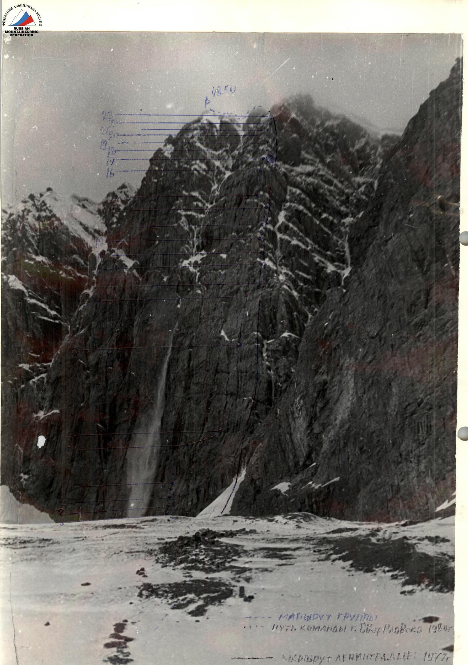
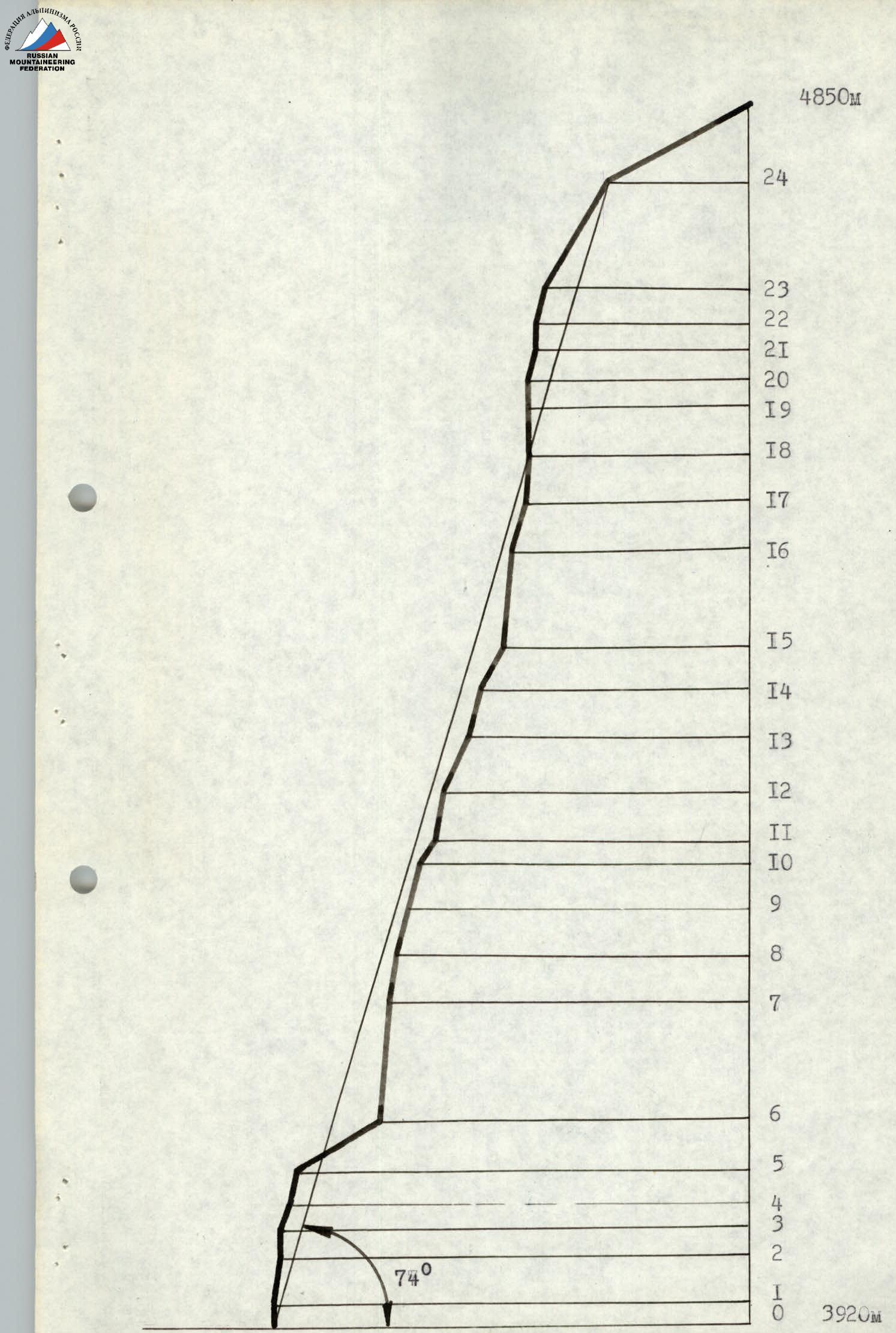
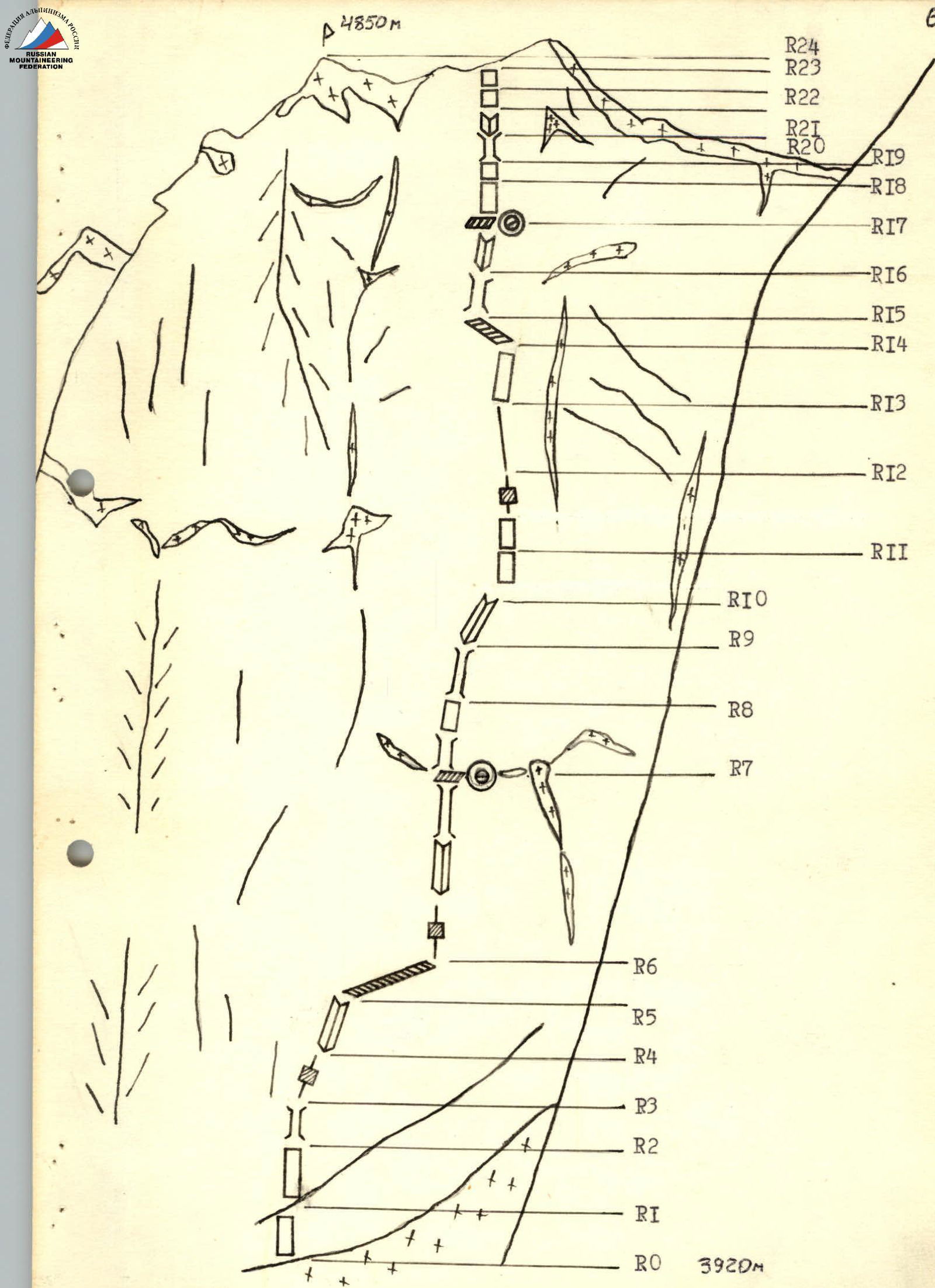
Route sketch with UIAA markings
Table of main route characteristics: Appendix No. 2
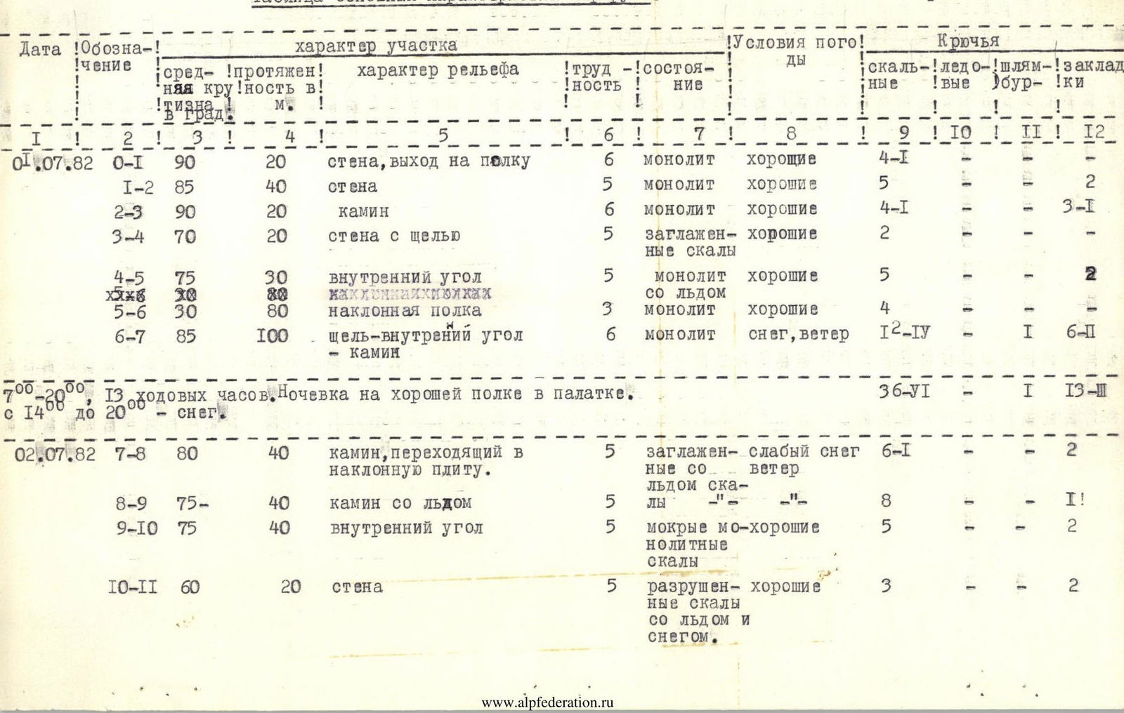
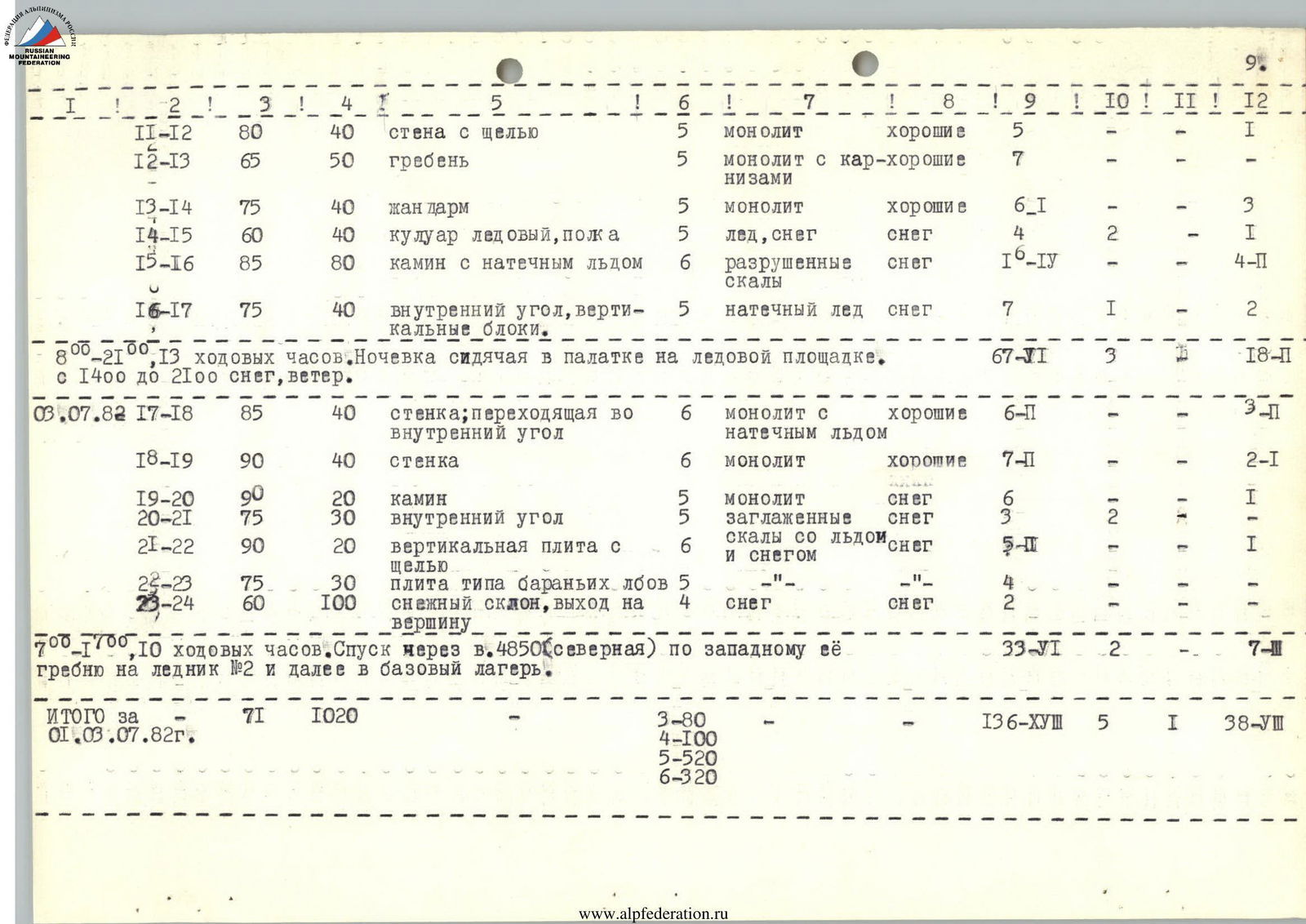
| Date | Section | Average steepness, ° | Length, m | Terrain characteristics | Difficulty | Condition | Weather conditions | Rock | Ice | Bolt | Chocks |
|---|---|---|---|---|---|---|---|---|---|---|---|
| 01.07.1982 | R0–R1 | 90 | 20 | wall, exit to a ledge | 6 | monolith | good | 4–1 | – | – | 2 |
| R1–R2 | 85 | 40 | wall | 5 | monolith | good | 5 | – | – | 2 | |
| R2–R3 | 90 | 20 | chimney | 6 | monolith | good | 4–1 | – | – | 3–1 | |
| R3–R4 | 70 | 20 | wall with a crack | 5 | smooth rocks | good | 2 | – | – | – | |
| R4–R5 | 75 | 30 | inner corner | 5 | monolith with ice | good | 5 | – | – | 2 | |
| R5–R6 | 30 | 80 | inclined ledge | 3 | monolith | good | 4 | – | – | – | |
| R6–R7 | 85 | 100 | crack-inner corner-chimney | 6 | monolith | snow, wind | 12–IV | 1 | – | 6–II | |
| 13 climbing hours. Overnight stay on a good ledge in a tent. Total for the period: rock – 36 (for belaying) / 6 (for ITO), ice – 1, bolt – –, chocks – 13 (for belaying) / 2 (for ITO). From 14:00 to 20:00 – snow. | |||||||||||
| 02.07.1982 | R7–R8 | 80 | 40 | chimney turning into an inclined slab | 5 | smooth rocks with ice | light snow, wind | 6–1 | – | – | 2 |
| R8–R9 | 75 | 40 | chimney with ice | 5 | – | – | 8 | – | – | 1 | |
| R9–R10 | 75 | 40 | inner corner | 5 | wet monolithic rocks | good | 5 | – | – | 2 | |
| R10–R11 | 60 | 20 | wall | 5 | destroyed rocks with ice and snow | good | 3 | – | – | 2 | |
| R11–R12 | 80 | 40 | wall with a crack | 5 | monolith | good | 5 | – | – | 1 | |
| R12–R13 | 65 | 50 | ridge | 5 | monolith with cornices | good | 7 | – | – | – | |
| R13–R14 | 75 | 40 | obstacle | 5 | monolith | good | 6–I | – | – | 3 | |
| R14–R15 | 60 | 40 | ice couloir, ledge | 5 | ice, snow | snow | 4 | 2 | – | 1 | |
| R15–R16 | 85 | 80 | chimney with flowstone ice | 6 | destroyed rocks | snow | 6–IV | – | – | 4–II | |
| R16–R17 | 75 | 40 | inner corner, vertical blocks | 5 | flowstone ice | snow | 7 | 1 | – | 2 | |
| 13 climbing hours. Sitting bivouac in a tent on an ice platform. Total for the period: rock – 67 (for belaying) / 6 (for ITO), ice – 3, bolt – –, chocks – 18 (for belaying) / 1 (for ITO). From 14:00 to 21:00 snow, wind. | |||||||||||
| 03.07.1982 | R17–R18 | 85 | 40 | wall turning into an inner corner | 6 | monolith with flowstone ice | good | 6–II | – | – | 3–II |
| R18–R19 | 90 | 40 | wall | 6 | monolith | good | 7–II | – | – | 2–1 | |
| R19–R20 | 90 | 20 | chimney | 5 | monolith | snow | 6 | – | – | 1 | |
| R20–R21 | 75 | 30 | inner corner | 5 | smooth rocks with ice | snow | 3 | 2 | – | – | |
| R21–R22 | 90 | 20 | vertical slab with a crack | 6 | monolith and snow | snow | 5–II | – | – | 1 | |
| R22–R23 | 75 | 30 | slab like "ram's foreheads" | 5 | – | – | 4 | – | – | – | |
| R23–R24 | 60 | 100 | snow slope, exit to the summit | 4 | snow | snow | 2 | – | – | – | |
| 10 climbing hours. Descent via v.4850 m (north) along its western ridge to glacier No. 2 and further to the base camp. |
Total for 01–03.07.1982:
- Average steepness: 71°
- Total length: 1020 m
- Length by difficulty categories:
- 3 – 80 m
- 4 – 100 m
- 5 – 520 m
- 6 – 320 m
- Total number of pitons:
- Rock – 136 (for belaying), 18 (for ITO)
- Ice – 5 (for belaying)
- Bolt – 1 (for belaying), 8 (for ITO)
- Chocks – 38 (for belaying)

(= pejuika)


