Passport
- Technical class
- Pamir-Alay, Guamysh gorge
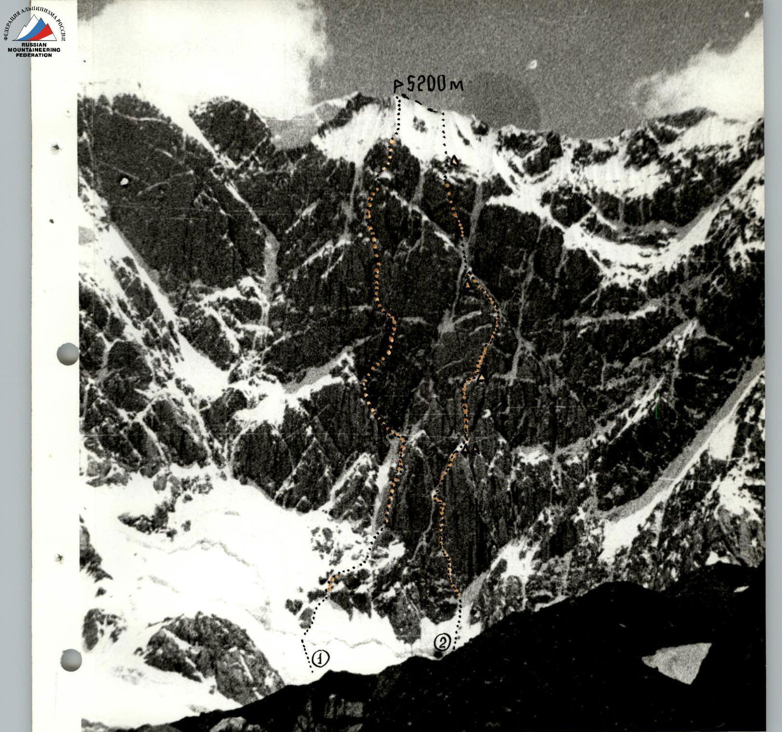
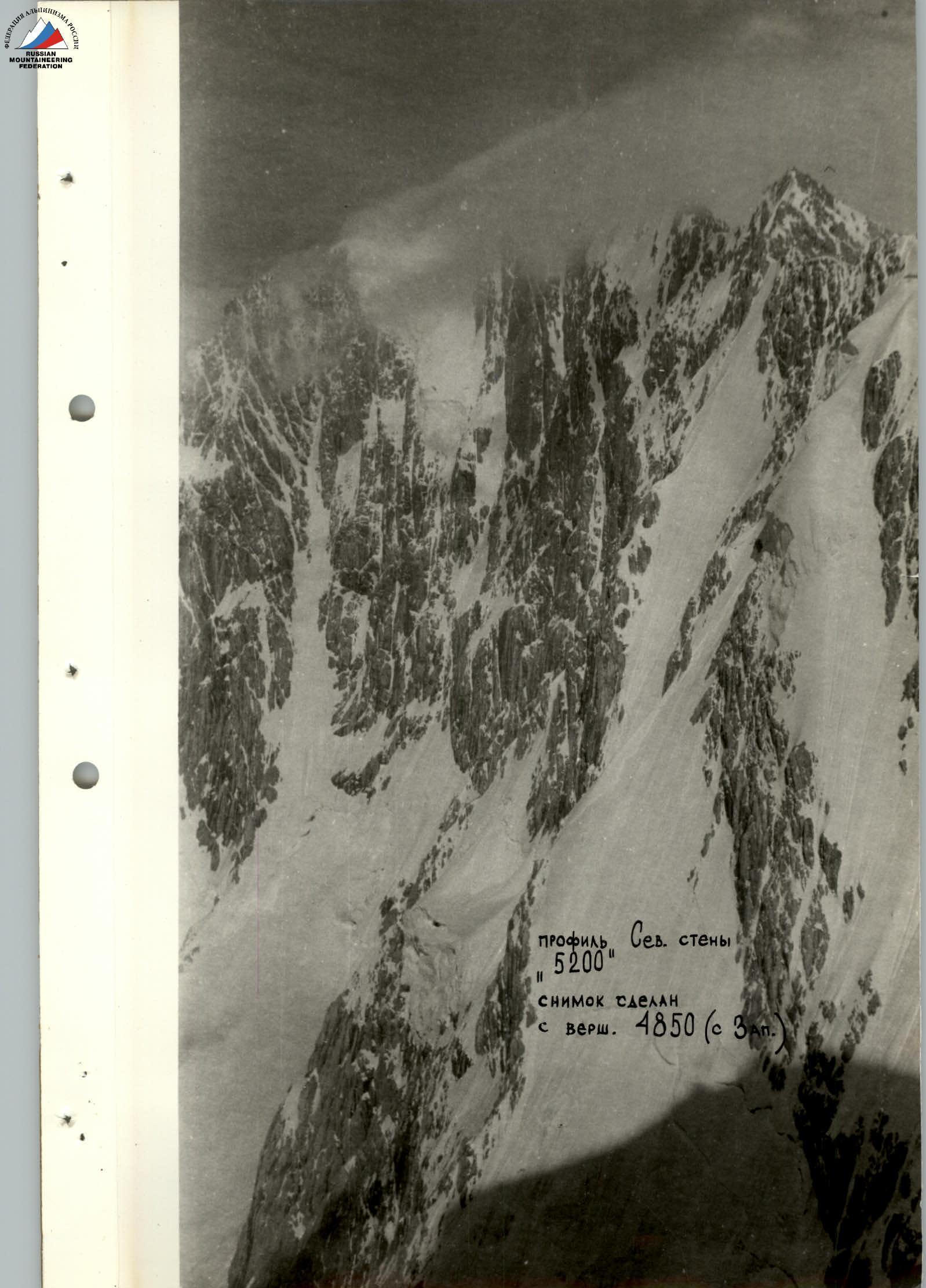
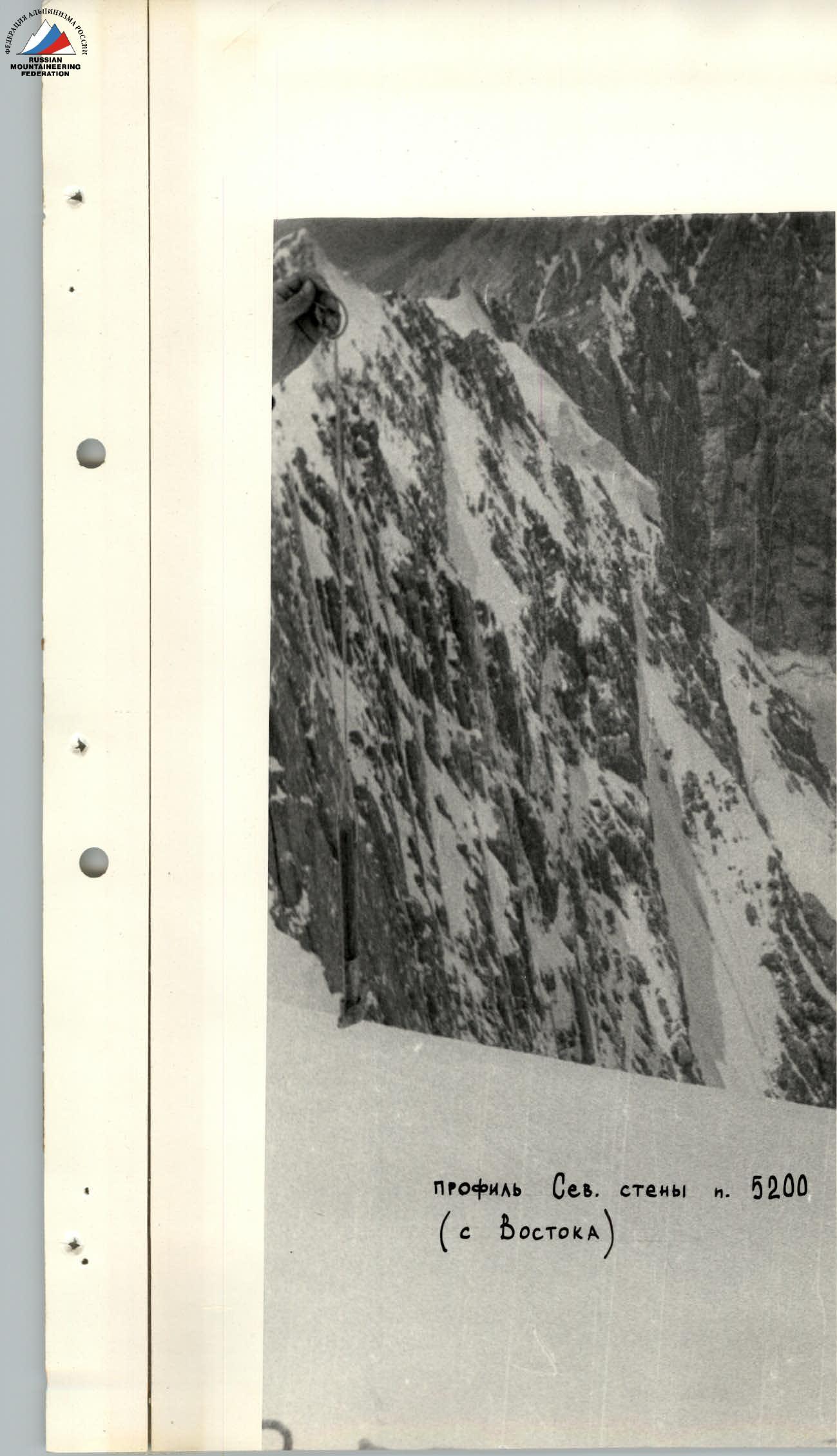
- Peak "5200"
- Cat. difficulty 6
- Elevation gain 100 m
Length of sections with cat. difficulty 5-6 — 930 m. Average steepness 75°.
- Pitons driven: rock — 108-XIII, ice — 55-X, bolt — 5-U, закладных — 36-II
- Walking hours — 42
- Overnights: 1 — in hammocks; 2 — two in hammocks; 3 — four on a platform cut out in a snowy ridge; 4 — platform for 6 people on a snow drift; 5 — platform cut out in a snow-ice slope for 6 people (semi-reclining).
- Leader — Efimov — Sergey Borisovich, MS. Participants — Samoylin Mikhail Alekseyevich, MS; Lebedikhin Alexey Veniaminovich, MS; Vinogradsky Eugene Mikhailovich, MS; Bryksin Valery Mikhailovich, MS; Abramov Sergey Semenovich, Candidate Master of Sports.
- Coach — Efimov Sergey Borisovich
- Approach to the route July 17, 1980.
Return July 22, 1980.

- Gorenchuk's route 1977, cat. difficulty 6 (1st place in the 1977 Championship).
- 1980 route, team from Sverdlovsk.
Brief geographical description of the area and sports characteristics of the ascent object
The ascent object — Peak "5200" is located in the northern spur of the Alay Range, south of the city of Haydarken. The Alay Range, in the section from Tan-Kul peak in the west to Kara-Kazyk pass in the east, forms a very complex orographic mountainous country with many spurs. One of the spurs extending north from the main ridge, west of Alaudin pass, is home to Rigi peak (5367 m), which is a nodal peak with two significant ridges extending west. The southern ridge separates the Hodjaachkan river valley (one of the Sokh tributaries) from the Guamysh river valley, in the upper reaches of which there is a fairly large glacier. Several peaks are located in the ridge forming the cirque of this glacier, including Peak "5200", whose slopes drop steeply to the north towards the glacier, presenting a significant sporting interest.
The uniqueness of this area lies in the fact that there are walls of completely different exposure in one cirque, and naturally, of different character — from a purely rock, "warm" eastern wall of Peak 4850 m to a harsh, icy, poorly lit northern wall of Peak "5200".
Peak "5200" is an independent peak located in the western ridge of Rigi peak. For the first time, the northern wall of Peak "5200" was climbed in 1977 by a team from Leningrad led by Yu. Gorenchuk. For this route, the Leningraders received first place at the 1977 USSR Championship. The route was classified as the highest category of difficulty — 6.
The climate of the area is moderately continental. It is generally considered that the area is "warm", but this season the weather was very unstable, with frequent thunderstorms and snowfalls.
The approach to the glacier cirque is quite simple: from the end of the road in the Alaudin gorge (20 km from Haydarken) along a trail through the Guamysh cattle pass at 4075 m — 5-6 hours of walking to the glacier tongue. From it to the start of the route — 2-3 hours first along a moraine trail and then along a calm glacier.
Route description
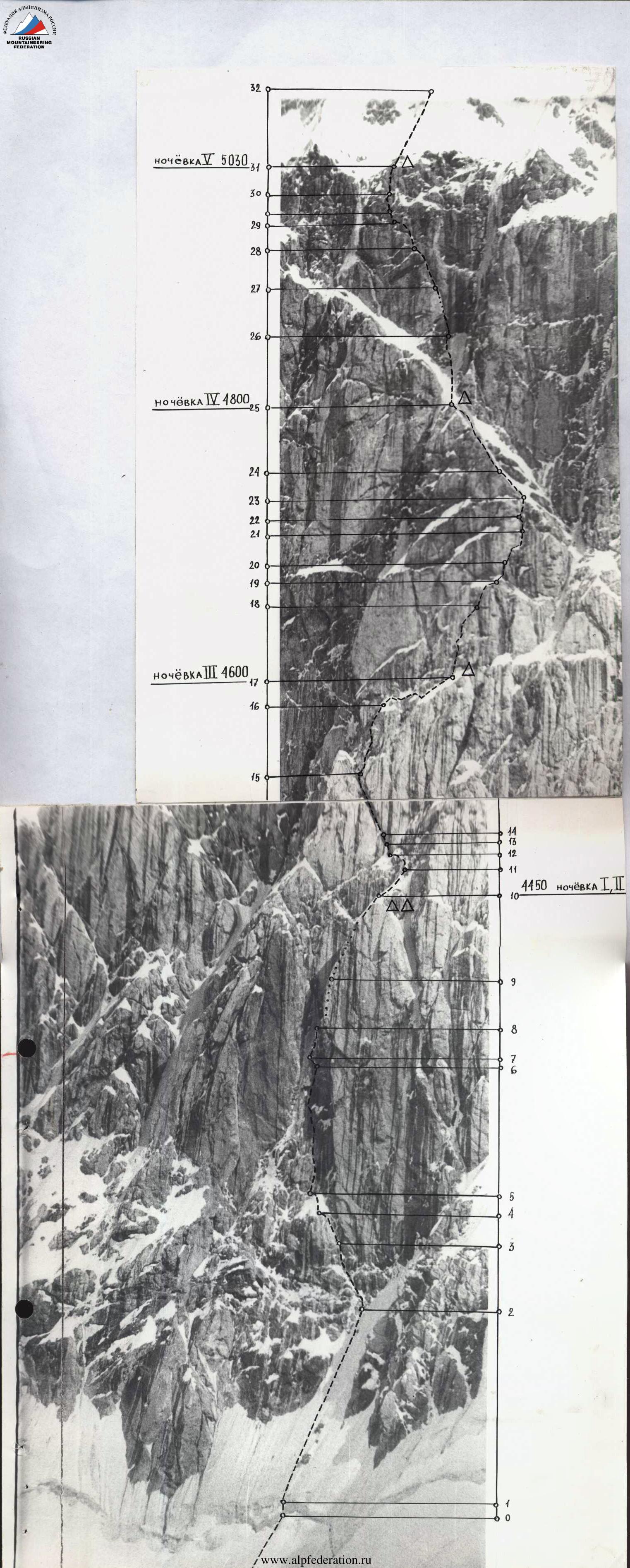
July 17, 1980. At 7:00, after linking up, we began to overcome the bergschrund near two rock islands (20 m, 85° — ice cut). Efimov, loading the ladders with either an ice axe or a hammer, passes these 20 m, having driven four pitons, and reaches an ice slope with a steepness of 60° (section R1).
Further, 120 m of ice with a steepness of 60°, in the upper part up to 65° (section R2). At 40 m, one intermediate ice screw is driven and two more at the insurance point. We reach the rocks without any problems. A very uncomfortable transition from ice to rocks. Further, the general direction is left-upwards under the "iron" wall. Along a rocky ledge with ice, we pass 35 m (65°), then another 15 m, but along ice-filled slabs (section R3).
Section R4 is an internal ice-filled corner — 25 m, 75°. The rocks are smoothed. Ice hammer and ice axe come into play, driven in turn where the ice is thicker. The section is passed on the front teeth of crampons. 2 ice pitons, 3 rock pitons.
Section R5 is a snow-ice ridge leading to the wall, passed without particular problems (20 m, 50°, 3 rock pitons). Efimov puts on galoshes.
Further up the wall, 100 m, 80° under a huge cornice (overhang up to 3 m). In the left part, where it approaches the left edge of the "iron", a passage is possible. Section R6 to the cornice is passed with very difficult climbing. Handholds are small but strong. There are places for driving pitons and закладок, and ladders are used in two places (12 rock pitons, 10 закладок).
The cornice (section R7) is passed on the left along the route in ladders (5 m, 100°, 5 pitons).
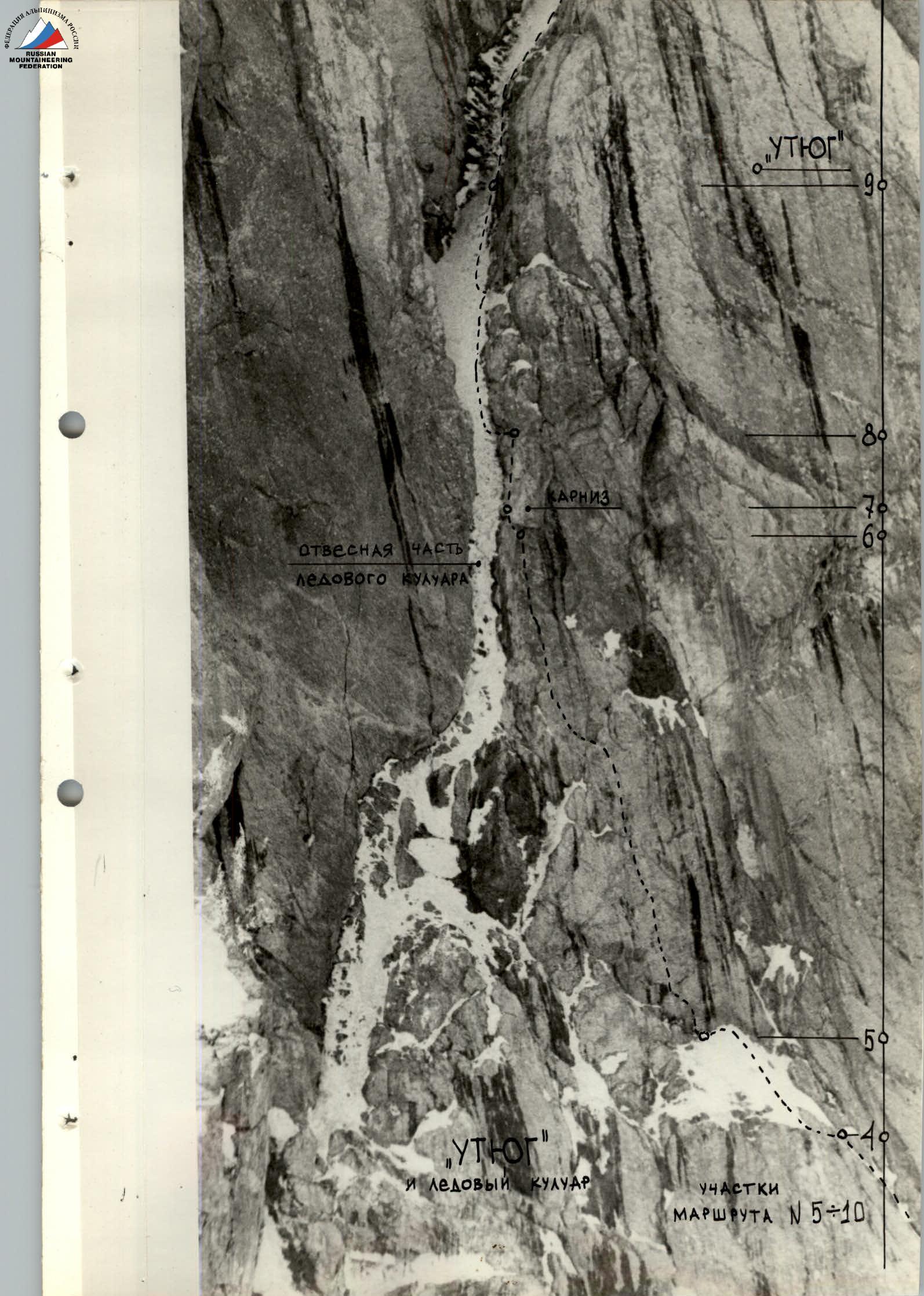
After that, we find ourselves on the left edge of the "iron", with monolithic, snow-covered rocks and signs of rockfall. There are no cracks. On the left is a couloir with ice, but in this part, the steepness is up to 85-90°, and the ice layer is very thin. We need to go up another 10 m — and only then can we swing into the couloir. These 10 m are passed with great difficulty, as there are no handholds (2 bolt pitons).
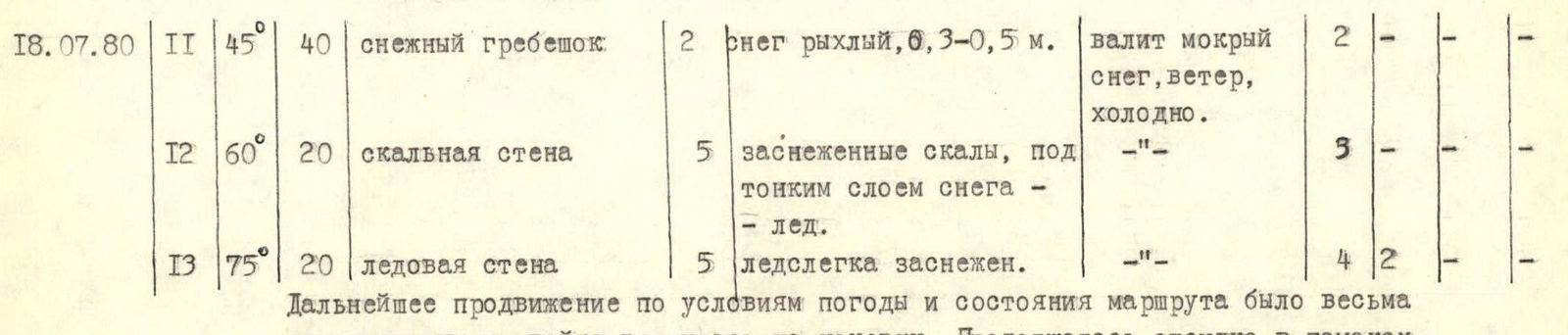
Lebedikhin puts on crampons and swings onto the ice. The weather starts to deteriorate. Drizzle begins. The first 20 m of the ice chute have a steepness of 70°, then 40 m — 60°. (Section R9, 4 ice pitons, 5 rock pitons). Lebedikhin overcomes the ice chimney — 50 m, 80° (section R10). Somewhere stones protrude, icicles hang, dripping water. The ice is fragile, crumbling under load. Very difficult passage. The rain is getting heavier. The altimeter shows 4450 m.
We try to quickly hang hammocks and cover ourselves with cloaks to avoid getting completely wet. The rain turns into wet snow, which continues throughout the night and into the morning. Moreover, the wind picks up. The cloaks start to get wet, and the down gear gets wet too.
During the day, as soon as the snow stops for a moment, Lebedikhin and Efimov try to start processing. They pass 40 m along the snow (section R11) and then traverse left-upwards along the rocks (section R12) and go up along the ice wall 20 m, 75° (section R13) to the base of a large rock wall. Further advancement proves impossible. There's a blizzard, and meltwater is flowing down the rocks. Even on steep sections, wet snow is stuck. The pair returns and settles back into hammocks, into their already wet sleeping bags.
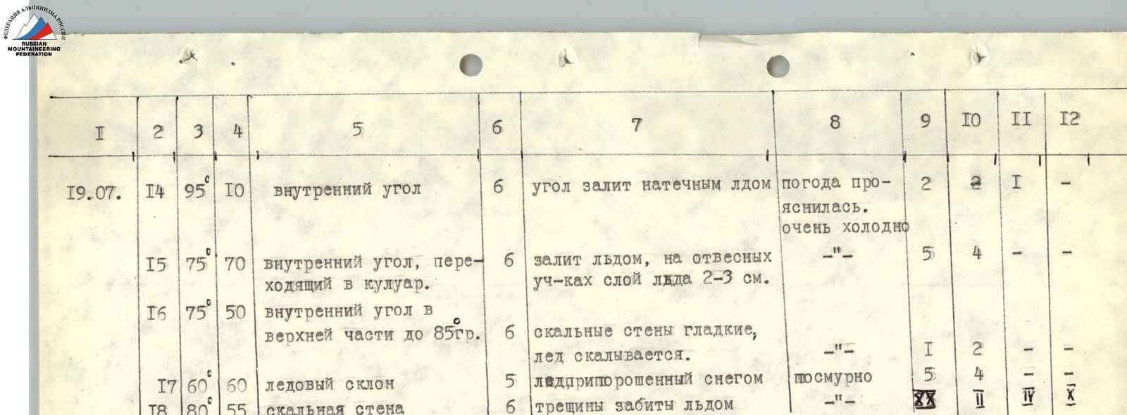
Only by morning does the snow stop. Chilled and soaked, we climb out of the hammocks to dry off a bit and rest from immobility. We set out at 12:00. We approach the large rock wall. We start passing the wall along an internal ice-filled corner. The lower part of it is 10 m overhanging at an angle of 95° (section R14), with smooth rocks without cracks. Efimov drives a bolt for insurance. Having swung into the internal corner, he passes another two ropes (70 m, 75°). 75° is the average steepness, but this section has two 2-3 m walls with a steepness of 85° — very difficult to overcome, as the ice layer on the rock is very thin — 2-3 cm (section R15).
In the upper part of this section, the internal corner widens, turning into a couloir. Further, the path goes right-upwards to the "bird's" wing — a characteristic snow patch, where we planned the second overnight stay.
Section R16 is a narrow internal corner 40 m long, with a steepness of 75°, and in the upper part, 1.5-2 m up to 85°. There are no places to drive pitons on the rock wall. The ice is crumbling. Difficult and dangerous climbing.
Further (section R17), the corner becomes less steep and turns into a steep ice slope with rock outcrops (the "bird's" wing), which we traverse to the right (60 m, 60°). 4 ice pitons and 5 rock pitons are driven. Here we start hanging hammocks under a cornice (space for two hammocks). On the ridge, we cut out a platform for a semi-reclining overnight stay for four people. Height 4600 m.
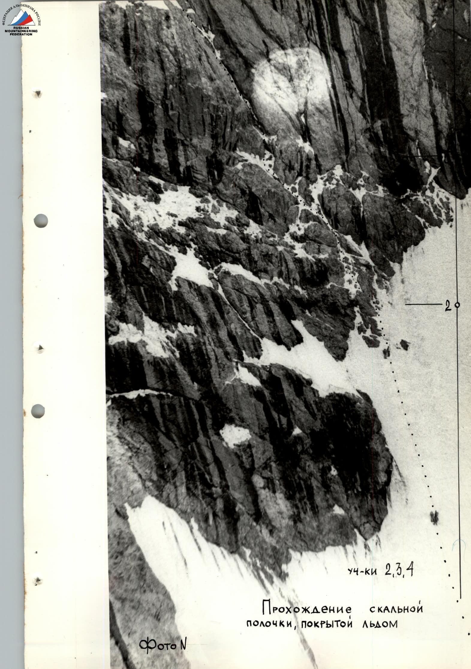
While preparing the overnight stay, Lebedikhin starts processing. The overall steepness of the visible 100-meter section of the wall is 80°. There are many overhanging sections, and the rocks have a fine "tile" structure and are covered with snow that fell the day before. Progress by free climbing is impossible. We have to clean the rocks, looking for cracks, which are very few, or try to use закладки. Lesha passes a 40-meter section with a steepness of 80° in 3.5 hours. At the same time, 4 bolt pitons, 15 rock pitons, and 10 закладных elements are used (stoppers). There are still 15 m of such climbing left to the internal corner.
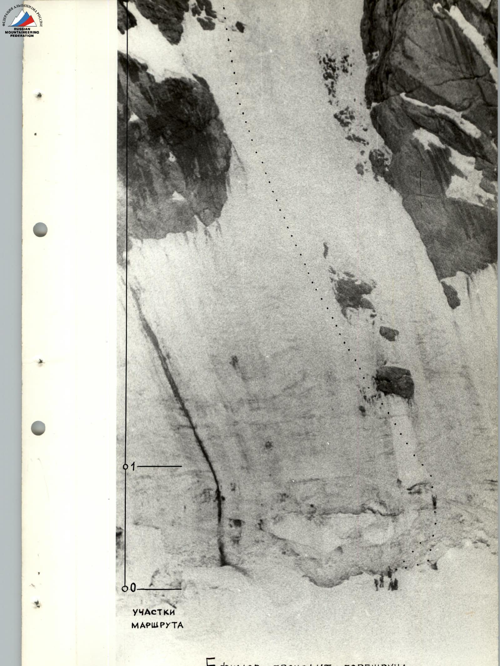
July 20. In the morning, we set out at 10:30. Efimov works first (section R18). He passes the перила, starts moving upwards. Again, from ladder to ladder, as there are few cracks, and those are filled with ice. He moves slowly from piton to piton: where he drives an ice piton halfway or a third, where he lays закладку. In total, 4 bolt pitons, 20 rock pitons, 2 ice pitons, and 10 закладок are used on section R18 with a steepness of 80° and a length of 55 m. Further — an internal corner filled with ice, going right-upwards (section R19) — 15 m, 75°. The side walls are smooth, monolithic, and there are no places to drive rock pitons. In the middle part, there is a 1.5-meter sheer section. The technique for passing such relief is already becoming apparent. With trial blows of a hammer and ice axe, the thickest part of the ice is determined, which can withstand the weight of the climber, and, loading the ice hammer and ice axe on the front teeth of crampons, the section is passed. Insurance is provided through an ice screw, on which, if it is driven in all the way, which was the case most of the time, a loop is put on and tightened under the base with a carabiner. The internal corner leads to a snow-ice slope with a steepness of 60° and a traverse to the right — 10 m under the base of a rocky sheer chimney.
The rocky chimney (section R20), although sheer, 10 m, 90°, is dry. Passage is made by jamming. The chimney leads to a small shoulder. This is already the beginning of the entrance to the right edge of "X". Further — a 2-meter drop (ice) and an entrance to an internal corner with ice between the wall and a rocky spur. Section R21. The wall is smooth. The exit is only possible along the ice, which initially represents a giant icicle. The walls start to be lit by the sun, the ice crust softens, and becomes fragile.
The beginning of section R21 — 3 m under 90° (ladder, ice axe, ice hammer, 1 ice piton), then it becomes less steep to 70° (10 m). Extremely tense climbing, which does not end even after a 3-meter narrow ledge leading to the right part of the wall at the junction with the couloir. Another 10 m up the ice wall 80° (section R22), or rather along the fronts filled with foamy ice 3-5 cm thick, sometimes along icicles, sometimes along cleaned rock handholds, very fragile. In this section, we had to clean the rock from ice, drive a bolt piton, and use a ladder to pass. At the end of the ice wall, a stone protruded, on which the перила were fixed. A slight flattening (2 m, 60°) and again a wall 75-80°, 20 m (section R23), which leads to the couloir. Having passed along the couloir 60 m, 60° (section R24), we felt that the layer of freshly fallen snow had become soggy and was becoming avalanche-prone. Samoylin puts on galoshes and exits onto the rocks. 80 m, 65°. Rocks like "ram's foreheads" (section R25). Climbing of medium difficulty leads under the intersection of couloirs "X". Here we planned to spend the night. Time 20:00. On a snow drift, we cut out a platform for 6 people. Excellent overnight stay. Height 4800 m.
Further, we had to cross the ice slope. Too early a departure was undesirable, as the upper part of the wall is lit at 7:00, and rocks start to fall, and then the sun disappears until 16:00.
July 21. Departure from the overnight stay at 10:30. Section R26 to the rocks is an ice wall 89 m: in the first half, the steepness is up to 60°, in the second — up to 65-70° when approaching the rocks, the steepness of the last 10 m reaches 75°. Bryksin works first. The ice is very hard, crumbling in lenses.
Further, we move straight up along the chimney of the wall. The overall steepness of the wall is 80°.
The first 40 m (section R27):
- The chimney is filled with a transparent layer of ice 3-10 cm thick.
- In some places, the ice is whitish, foamy.
- In the upper part, the chimney is overhanging, and the passage is blocked by a thicket of icicles.
Lebedikhin goes first. Using pitons and закладки, as well as ice pitons driven in a third or half, he passes these 40 m. How he did it remains a mystery.
Further, the chimney turns into an internal corner.
A smooth internal corner (section R28):
- Represents pure, smoothed rocks.
- Samoylin in galoshes goes up (40 m, 75°).
- There are no places to drive pitons.
- In the middle part, we had to drive a bolt piton.
The next 40 m (section R29) is a wall with an overhang:
- The path goes around the overhang — a traverse to the left.
- In the middle part, it becomes more difficult.
- Climbing is very difficult (40 m, 80°).
The wall becomes less steep to 75°, but the rocks become so destroyed and have a "tile" structure that the technical difficulty of the passage does not decrease. From the ledge, there is a 5-meter smooth wall, and then 40 m, 75° (section R30) and another 40 m, 70° (section R31) to a snow-ice field leading to the ridge.
We settle in for the night, having cut out a platform for 6 people in the rocks. Time 20:00. Height 5030 m.
July 22, 1980. Departure at 7:30 in the morning. The first two ropes — 80 m (section R32) — ice with a steepness of 50°. Abramov goes first. Further, there is 1.5 ropes of ice, greenish in the upper part, like bottle glass. Steepness 60° (section R33). At 9:00, we exit onto the ridge and at 9:30 stand on the summit. The altimeter shows 5230 m. The sun is shining. We didn't expect that the weather would change sharply, and a real winter blizzard would start, which would torment us during the entire descent for 9 hours.
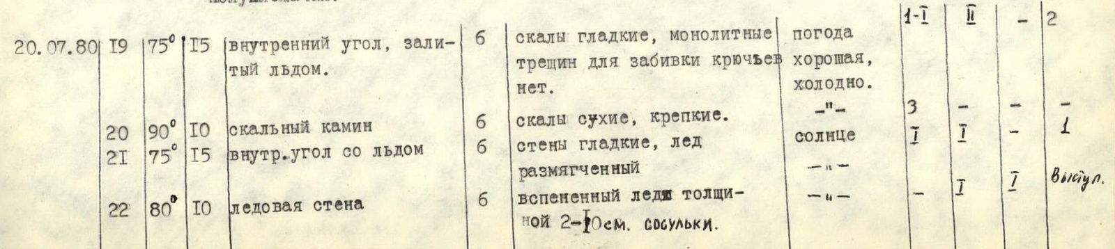
TABLE OF MAIN CHARACTERISTICS OF THE ASCENT ROUTE
| Date | Section designation | Steepness (average) | Length (m) | Character of relief | Cat. difficulty of section | State of relief | Weather conditions | Rock pitons | Ice pitons | Bolt pitons | закладных elements |
|---|---|---|---|---|---|---|---|---|---|---|---|
| July 17, 1980 | R1 | 85° | 20 | Ice slope (bergschrund) | 5 | Hard ice | Cold | — | 19 | — | — |
| R2 | 60° | 120 | Ice slope | 4 | Hard clean ice | — | 1 | 9 | — | — | |
| R3 | 65° | 45 | Rocks filled with ice | 4 | Smooth rocks, hard ice | — | 5 | 1 | — | — | |
| R4 | 75° | 25 | Internal corner with ice | 5 | Smoothed rocks, ice accretion | — | 3 | 2 | — | — | |
| R5 | 50° | 20 | Snow-ice ridge | 3 | Dense firn turning into ice | — | 3 | — | — | — | |
| R6 | 80° | 100 | Rock wall | 6 | Small strong handholds | Weather deteriorating | 10–11 | — | — | 10 | |
| R7 | 100° | 5 | Rock cornice | 6 | Strong rocks | Rain starts | 5 | — | — | — | |
| July 17, 1980 | R8 | 80° | 10 | External corner | 6 | Smoothed rocks without handholds | Rain | — | — | 11 | — |
| R9 | 65° | 60 | Ice chute | 5 | Softened wet ice | — | 5 | 4 | — | — | |
| R10 | 80° | 50 | Ice chimney with icicles and rock outcrops | 6 | Fragile ice, thin layer covering rocks, water flowing | Rain with wet snow | 6 | 3 | — | — |
Start of work on the route — 7:00. End — 17:30. Walking hours — 10 h 30 min. Height — 4450 m. Elevation gain — 320 m. Overnight stay in hammocks on the "iron".
Further progress due to weather and route conditions was very doubtful, and the pair returned to the overnight stay. Continued to sit out in hammocks. Work took 1 h 30 min.
| Date | Section designation | Steepness (average) | Length (m) | Character of relief | Cat. difficulty of section | State of relief | Weather conditions | Rock pitons | Ice pitons | Bolt pitons | закладных elements |
|---|---|---|---|---|---|---|---|---|---|---|---|
| July 18, 1980 | R11 | 45° | 40 | Snow ridge | 2 | Loose snow, 0.3–0.5 m | Wet snow falling, wind, cold | 2 | — | — | — |
| R12 | 60° | 20 | Rock wall | 5 | Snow-covered rocks, thin layer of snow — ice | — | 3 | — | — | — | |
| R13 | 75° | 20 | Ice wall | 5 | Ice slightly covered with snow | — | 4 | 2 | — | — |
Height — 4600 m. Departure from overnight stay — 12:00. End of work — 21:00. Elevation gain — 150 m. Working day — 9 h. Overnight stay conditions: two in hammocks, four on a platform cut out in an ice-snow ridge. Semi-reclining overnight stay.
| Date | Section designation | Steepness (average) | Length (m) | Character of relief | Cat. difficulty of section | State of relief | Weather conditions | Rock pitons | Ice pitons | Bolt pitons | закладных elements |
|---|---|---|---|---|---|---|---|---|---|---|---|
| July 19, 1980 | R14 | 95° | 10 | Internal corner | 6 | Corner filled with ice accretion | Weather cleared up, very cold | 2 | 2 | 1 | — |
| R15 | 75° | 70 | Internal corner turning into a couloir | 6 | Filled with ice, 2-3 cm ice layer on steep sections | — | 5 | 4 | — | — | |
| R16 | 75° | 50 | Internal corner, in upper part up to 85° | 6 | Rock walls smooth, ice crumbling | — | 1 | 2 | — | — | |
| R17 | 60° | 60 | Ice slope | 5 | Ice dusted with snow | Overcast | 5 | 4 | — | — | |
| R18 | 80° | 55 | Rock wall | 6 | Cracks filled with ice | — | 2 | — | — | 10 | |
| July 20, 1980 | R19 | 75° | 15 | Internal corner filled with ice | 6 | Smooth monolithic rocks, no cracks to drive pitons | Weather good, cold | — | — | — | 2 |
| R20 | 90° | 10 | Rock chimney | 6 | Dry strong rocks | — | 3 | — | — | — | |
| R21 | 75° | 15 | Internal corner with ice | 6 | Smooth walls, softened ice | Sun | 1 | — | — | 1 | |
| R22 | 80° | 10 | Ice wall | 6 | Foamy ice 2-10 cm thick, icicles | — | 1 | 1 | — | — | |
| R23 | 75° | 20 | Ice wall | 6 | Foamy ice accretion | Sun | — | — | — | — | |
| R24 | 60° | 60 | Snow-ice couloir | 4 | Ice covered with wet soggy snow | — | — | 3 | — | — | |
| R25 | 65° | 80 | External corner | 5 | Rocks like "ram's foreheads" | — | 10 | — | — | 5 |
Height 4800 m. Overnight stay under "X". Departure time 10:30. End of work — 20:00. Working time — 9 h 30 min. Elevation gain — 200 m. Overnight stay conditions: platform for 6 people on a snow drift.
| Date | Section designation | Steepness (average) | Length (m) | Character of relief | Cat. difficulty of section | State of relief | Weather conditions | Rock pitons | Ice pitons | Bolt pitons | закладных elements |
|---|---|---|---|---|---|---|---|---|---|---|---|
| July 21, 1980 | R26 | 65–70° | 80 | Ice wall | 5 | Clean very hard ice, crumbling in lenses | Cold weather, working in shade | 7 | — | — | — |
| R27 | 80° | 40 | Chimney | 6 | Chimney filled with transparent ice layer 3-10 cm thick | — | 2 | 1 | 4 | 1 | |
| R28 | 75° | 40 | Rock internal corner | 6 | Smoothed rocks | — | 2 | 1 | — | 1 | |
| R29 | 80° | 40 | Wall with overhang | 6 | Rocks местами destroyed | Sun | 3 | — | — | 4 | |
| R30 | 75° | 40 | Wall | 6 | Smooth slab | — | 5 | — | — | — | |
| R31 | 70° | 40 | Wall | 4 | Very destroyed rocks | Good weather | 4 | — | — | 2 |
Overnight stay 5030 m. Start of work 10:30. End 20:00. Working time — 9 h 30 min. Elevation gain — 230 m. Overnight stay conditions: platform for 6 people cut out in a snow-ice slope.

Team leader and coach S. Efimov.
| Date | Section designation | Steepness (average) | Length (m) | Character of relief | Cat. difficulty of section | State of relief | Weather conditions | Rock pitons | Ice pitons | Bolt pitons | закладных elements |
|---|---|---|---|---|---|---|---|---|---|---|---|
| July 22, 1980 | R32 | 50° | 80 | Snow-ice slope | 3 | Dense firn | Cold, clear | 4 | — | — | — |
| R33 | 60° | 50 | Snow-ice slope | 4 | Hard greenish ice | — | 4 | — | — | — |
Departed from overnight stay at 7:30, exited onto the ridge at 9:00, and reached the summit along the snowy ridge at 9:30. Working time — 2 h. Elevation gain — 200 m.