Ascent Log
Ascents
Ascent category — technically challenging
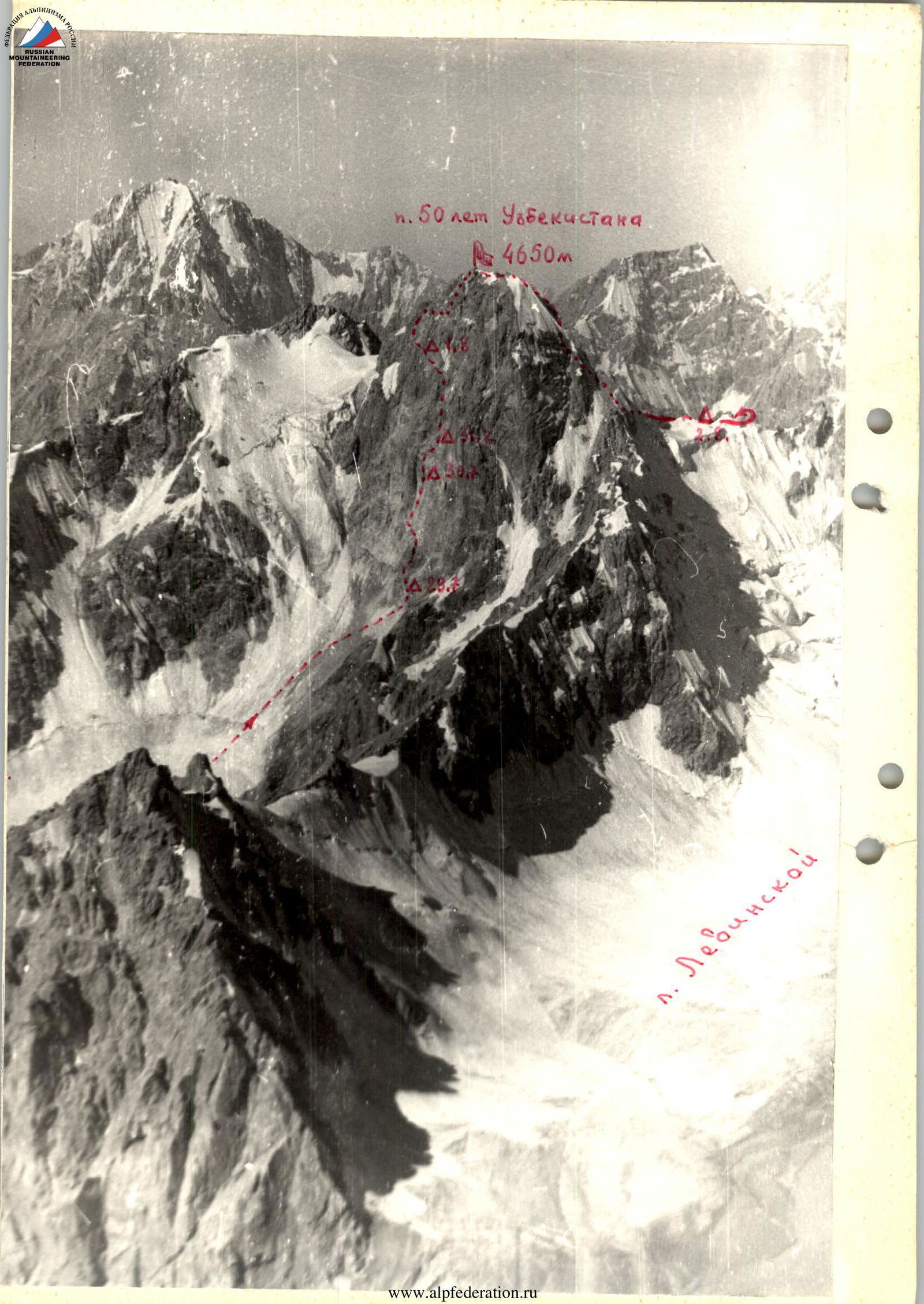
Ascent area — southern spurs of the Alay Ridge, Lenin Peak area
Ascent route — center of the northeastern wall of Peak 50 Years of Uzbekistan, elevation 4650 m
Ascent characteristics:
- Wall height difference — 1012 m
- Average steepness — 72°
- Length of main sections:
- 4th difficulty category — 48 m
- 5th difficulty category — 608 m
- 6th difficulty category — 359 m
Pitons used:
- Rock pitons — 234 pcs
- Ice screws — 13 pcs
- Bolts — none
Time spent on the wall — 62 hours
Number of bivouacs and their characteristics: 5 bivouacs;
- 29.07 — sitting
- 30.07 — sitting
- 31.07 — semi-reclining without water
- 01.08 — semi-reclining
- 02.08 — lying down
Team name: Instructor team of "Dugoba" alpine camp
Team leader, members, and their qualifications:
- Team leader — Oleg Ivanovich Shumilov — Master of Sports of the USSR
- Members:
- Vladislav Nikolaevich Ovsyannikov — Candidate for Master of Sports
- Anatoly Nikitovich Semenov — Candidate for Master of Sports
- Valery Yakovlevich Vekolyar — Candidate for Master of Sports
- Team coach — Vladimir Sergeevich Erolov — Master of Sports of the USSR
Dates of departure and return: departure — July 26, 1974, return — August 4, 1974
 www.alp-federation.ru↗
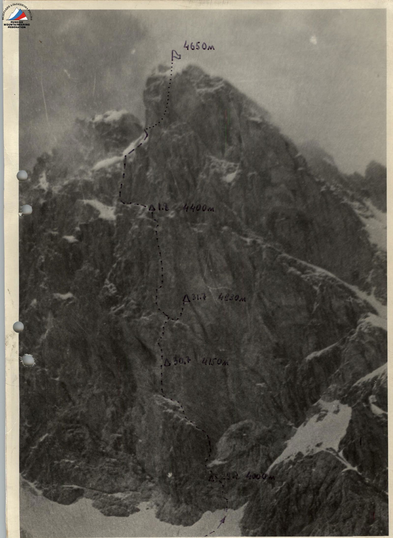 www.alp-federation.ru↗
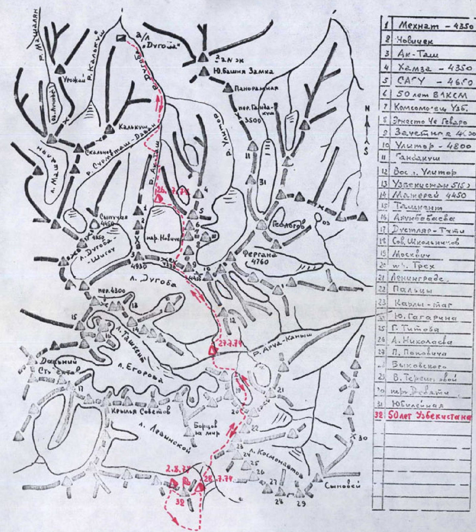
Orographic diagram of the "Dugoba" alpine camp area
Table
Main characteristics of the route through the center of the northeastern wall of Peak 50 Years of Uzbekistan
| Section # | Steepness | Section length | Terrain characteristics | Tech. grade | Movement method | Time | Pitons |
|---|---|---|---|---|---|---|---|
| July 29, 1974 | |||||||
| R1 | 30–40° | 200 m | Snow-ice slope | 4th cat. | Simultaneous movement, in ropes, visibility 150 m | 14:00 | |
| R2 | up to 60° | 4 rope lengths | Ice slope with bergschrund 5 m wide | 5th cat. | Alternate movement, in ropes. First with lower belay. Others on fixed ropes | 9 | |
| R3 | 70° | 10 m | Rock wall | 5th cat. | 2 | ||
| R4 | 50° | 5 m | Inclined slab | 5th cat. | 1 | ||
| R5 | 60° | 10 m | Wall | 6th cat. | 3 | ||
| R6 | 60° | 10 m | Smooth inner corner | 5th cat. | 2 | ||
| R7 | 50° | 5 m | Inclined slab | 5th cat. | 19:00 | 9 | |
| Platform 1.5x1.0 m, sitting, 4000 m | |||||||
| July 30, 1974 | |||||||
| R8 | 50° | 15 m | Inclined slabs | 5th cat. | First with lower belay, others on fixed ropes | 7:00 | 4 |
| R9 | 65° | 25 m | Smooth inner corner with ice | 5th cat. | 3 | ||
| R10 | 80° | 15 m | "Black wall" with reverse holds | 6th cat. | 3 | ||
| R11 | 70° | 30 m | Steep slabs with ice accretion | 6th cat. | 2 | ||
| R12 | 90° | 10 m | Wall | 6th cat. | 2 | ||
| R13 | 60° | 20 m | Steep slabs with ice accretion | 6th cat. | 3 | ||
| R14 | 95° | 10 m | Wall with overhang | 6th cat. | Using ladders, visibility 100–150 m | 3 | |
| R15 | 85° | 10 m | Wall with holds | 6th cat. | 3 | ||
| R16 | 95° | 10 m | Wall with overhang | 6th cat. | |||
| July 31, 1974 | |||||||
| R17 | 6 m | Horizontal ledge | 4th cat. | Sunny, warm | 7:00 | 1 | |
| R18 | 95° | 15 m | Inner corner with overhang | 6th cat. | First with lower belay, others on fixed ropes | 5 | |
| R19 | 90–95° | 5 m | Wall with overhang | 6th cat. | Same, using chocks | 2 | |
| R20 | 90° | 8 m | Inner corner, ice-covered | 6th cat. | 2 | ||
| R21 | 90° | 5 m | Smooth wall, ice-covered | 6th cat. | 1 | ||
| R22 | 95° | 4 m | "Separation" wall | 6th cat. | 1 | ||
| R23 | 50° | 8 m | "Separation" ridge | 6th cat. | 2 | ||
| R24 | 80° | 5 m | Wall of second "separation" | 6th cat. | 2 | ||
| R25 | 90° | 12 m | Wall of second "separation" | 6th cat. | 5 | ||
| R26 | 6 m | Inclined ledge under overhanging wall | 4th cat. | 1 | |||
| R27 | 80° | 20 m | Destroyed wall under overhanging loose wall | 5th cat. | 20:00 10:00 | 13 | |
| Platform 2x3 m, semi-reclining, no water, 4230 m | |||||||
| August 1, 1974 | |||||||
| R28 | 80° | 20 m | Descent via sport climbing last | 7:00 | |||
| R29 | 6 m | Inclined ledge under overhanging wall | 4th cat. | ||||
| R30 | 60° | 8 m | Steep slabs | 5th cat. | First with lower belay, others on fixed ropes | ||
| July 28, 1974 | |||||||
| R31 | 30 m | Ledge, partially disappearing | 4th cat. | ||||
| R32 | 85° | 6 m | Wall resembling "ram's foreheads" with ledge at the end | 6th cat. | 1 | ||
| R33 | 90° | 6 m | Couloir with smooth walls | 6th cat. | 1 | ||
| R34 | 50° | 12 m | Smooth slabs | 5th cat. | 2 | ||
| R35 | 75° | 8 m | Wall with ledge at the end for 2 people | 5th cat. | 2 | ||
| R36 | 90° | 6 m | Wall | 6th cat. | 2 | ||
| R37 | 80–85° | 40 m | Inner corner with three overhanging sections. Length of overhanging sections is 15 m. Rocks are wet. | 6th cat. | 12 | ||
| R38 | 95° | 18–20 m | Overhanging wall of inner corner | 6th cat. | Rocks are wet. Exit under overhang. | 6 | |
| R39 | 3 m | Traverse of overhang to the left | 6th cat. | ||||
| R40 | 95° | 6 m | Wall of left overhang | 6th cat. | 2 | ||
| R41 | 85° | 9 m | Inner corner with smooth walls | 6th cat. | 2 | ||
| R42 | 95° | 3 m | Wall | 6th cat. | 1 | ||
| R43 | 75° | 15 m | Inner corner with ledge. At the end of section for 4 people. | 6th cat. | 3 | ||
| July 28, 1974 | |||||||
| R44 | 85° | 8 m | Wall | 5th cat. | First with lower belay, others on fixed ropes | ||
| R45 | 50° | 10 m | Inclined slabs | 5th cat. | 5 | ||
| R46 | 70° | 17 m | Wall | 5th cat. | 2 | ||
| R47 | 50° | 20 m | Rocks resembling "ram's foreheads" with ledge at the end for 4–5 people | 4th cat. | 20:00 13:00 | 13 | |
| August 2, 1974 | |||||||
| R48 | 45–50° | 10 m | Narrow, stony ledge | 4th cat. | Rockfall hazard!!! | 7:00 | 1 |
| R49 | up to 90° | 30 m | Ridge bordering couloir on the right with ledge at the end for 2 people | 5th cat. | 6 | ||
| R50 | 65° | 12 m | Traverse left across wall, then across snow-ice couloir to rock island in the middle | 5th cat. | 2 | ||
| R51 | 90° | 18 m | Wall of rock island with ledge for 2 people at the end | 6th cat. | 5 | ||
| R52 | 65° | 15 m | Traverse right across inclined slabs covered with ice | 5th cat. | 3 | ||
| R53 | 45° | 1.5 rope lengths | Rocks resembling "ram's foreheads" with ice, leading under overhanging wall of peak | 5th cat. | 3 | ||
| July 28, 1974 | |||||||
| R54 | 60° | 15 m | Traverse left across snow-ice couloir | 5th cat. | First with lower belay, others on fixed ropes. Rockfall hazard!!! | 2 | |
| R55 | 60° | 18 m | Very destroyed, overhanging wall of couloir | 5th cat. | 6 | ||
| R56 | 70° | 12 m | Traverse of snow-ice couloir upward to the right | 5th cat. | 2 | ||
| R57 | 90° | 20 m | Right wall of couloir up to its narrowing | 6th cat. | 6 | ||
| R58 | 95° | 9 m | Left wall of couloir | 6th cat. | Using ladders | 2 | |
| R59 | 50° | 8 m | Rocks resembling "ram's foreheads", ice-covered | 5th cat. | Same, without backpacks | 2 | |
| R60 | 75° | 25 m | Traverse upward to the right across inclined slabs toward "separation". Rocks are destroyed!! | 5th cat. | 4 | ||
| R61 | 90° | 20 m | Bypassing overhanging wall above "separation" | 6th cat. | 6 | ||
| R62 | 70° | 25 m | Inclined slabs, ice-covered | 6th cat. | 2 | ||
| Summit!!! Elevation 4650 m. Summit is a 6x6 m platform with a stone table in the western part. | |||||||
| August 3, 1974 | |||||||
| R63 | 50° | 2 rope lengths | Snow-ice ridge | 3rd cat. | Descent with alternate belay | 4 | |
| R64 | 75° | 30 m | Rock-snow-ice wall from "ram's forehead" toward rock dumps | 5th cat. | 3 | ||
| R65 | 95° | 40 m | Rocks. From snow ledge across ice wall through 2 rock dumps. Rope left on pitons and loop | 5th cat. | 3 | ||
| R66 | 60° | 40 m | Across snow-ice wall toward "ram's forehead" | 5th cat. | 3 | ||
| R67 | 90° | 40 m | Rock wall | 6th cat. | 3 | ||
| R68 | 65–75° | 12 m | Across ice and rock ridge | 5th cat. | 3 | ||
| R69 | 80° | 25 m | Rightward across snow-ice couloir onto scree of saddle | 5th cat. | 3 | ||
| R70 | up to 60° | 2 rope lengths | Wide scree ridge leading to saddle | 4th cat. | Simultaneous movement in ropes | 21:00 14:00 | 4 |
| On ledge in scree ridge, 4300 m. | |||||||
| R71 | 45–50° | 4300 m | Wide scree couloir. From 4300 m to fine, medium, and coarse scree down to 3100 m in Nakhdara gorge | 4th cat. | Simultaneous movement without ropes | 6:00 4:00 |
Detailed Description of Route Characteristics
The route begins from the moraine under Peak 50 Years of Uzbekistan, near a lake on the moraine. The lake offers comfortable bivouac sites at an elevation of about 3750 m. It takes 2–2.5 hours to walk from the "White Glade" bivouac sites to the lake.
The route proceeds from the lake along the moraine for 30 minutes, gradually transitioning into a snow-ice slope.
Section R1. Across a snow-ice slope with a steepness of 30–40° and a length of about 200 m, movement is simultaneous in ropes. A hidden crevasse is suspected under the slope. We start the route at 14:00. The weather is poor, with periodic fog, visibility not exceeding 150–200 m, and snowfall. We plan to bivouac on the wall today, July 29, 1974.
Section R2. The snow-ice slope becomes steeper, up to 60°, with ice covered by a thin layer of snow and rock fragments protruding from under the ice. The section is 2 rope lengths long and features a 5 m wide bergschrund, which is crossed using a thin snow bridge with careful alternate belaying. The section is technically challenging. From the bergschrund, we move toward the wall, approximately 150 m to the right of the central couloir, where water flows and rocks frequently fall.
Section R3. We ascend a 10 m monolithic rock wall with a steepness of 70°, using lower belay, to reach inclined slabs. It's snowing, and the rocks are slippery, making this section extremely difficult. We switch to "Vibram" boots and decide to progress by setting up complex fixed ropes.
Section R28 Descent via sport climbing last.
Section R29 This is the same as Section R26 from the previous day.
Section R30 From the ledge, 8 m up steep 60° slabs to a narrow ledge, moving on fixed ropes with backpacks.
The detailed description continues for all sections up to R71, detailing the terrain, steepness, movement techniques, and challenges faced during the ascent and descent.
List of equipment used by the team:
- Titanium carabiners — 35 pcs
- Steel carabiners — 16 pcs
- Titanium pitons:
- universal — 35 pcs
- channel-shaped various — 30 pcs
- petal-shaped — 10 pcs
- titanium ice screws — 6 pcs
- screw-type ice screws — 3 pcs
- 2-step ladders — 2 pcs
- 3-step ladders — 4 pcs
- Main ropes 12 mm — 5 pcs, 40 m each
- Cut-off boots — 3 pairs
- Loops from main rope — 10 pcs, 3 m each
- Vibram boots — 1 pair
- Rock hammers — 2 pcs
- Crampons — 4 pairs
- Ice axes — 2 pcs
- Belay harnesses — 8 pcs
- Reepschnur, loops:
- 4 pcs, 1.5 m each
- 4 pcs, 5 m each
The team had 35 bolt pitons and 3 bolts on the route but completed the wall without using bolt technique. The entire route was traversed in rubber boots despite unfavorable weather conditions for the ascent.