Report
On the second ascent to the summit of Ossonali, 4855 m, category 5B, Alai ridge, Kok-Su gorge: by a team from the Odessa regional council of the "Avangard" sports society, as a duo.
July 9-11, 1978
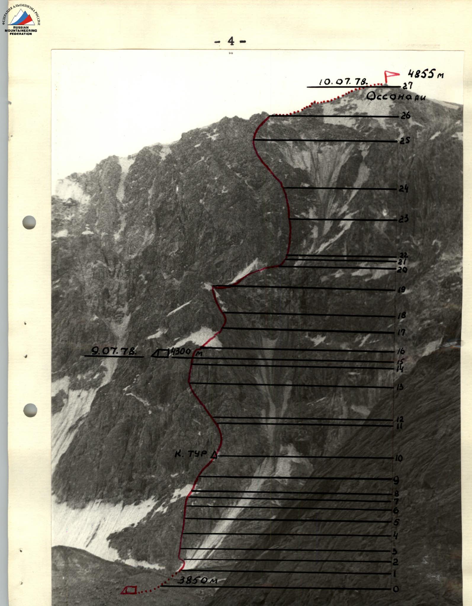
 General view of the summit.

Map scheme of the Alai ridge (Kok-Su area)
Table of main route characteristics.

| DATE | DESIGNATION | AVERAGE SLOP | LENGTH IN METERS | RELIEF CHARACTER | DIFFICULTY | WEATHER CONDITIONS | ROCK | ICE | BOLTS | NUTS |
|---|---|---|---|---|---|---|---|---|---|---|
| July 9, 1978 | R0–R1 | 40 | 60 m | avalanche cone | 2 | rockfall hazard, good | belay via ice axe | |||
| Departure at 6:00 | R1–R2 | 50 | 10 m | wall | 4 | monolithic | 3 | |||
| R2–R3 | 65 | 30 m | wall | 5 | flow ice | 4 | 2 | 1 | 4 | |
| R3–R4 | 55 | 30 m | glacial roches moutonnées | 5 | monolithic | 3 | 5 | |||
| R4–R5 | 50 | 30 m | ice board | 4 | ice | 2 | ||||
| R5–R6 | 65 | 40 m | wall | 5 | shattered | 4 | 3 | 2 | ||
| R6–R7 | 50 | 20 m | slab | 3 | monolithic | 2 | 2 | |||
| R7–R8 | 70 | 10 m | wall | 6 | monolithic | 2+2 | 1 | 1+1 | ||
| R8–R9 | 65 | 20 m | terrace | 3 | shattered | 1 | 2 | |||
| Control point | R9–R10 | 75 | 30 m | wall | 6 | shattered | 3 | 1 | ||
| R10–R11 | 80 | 30 m | wall | 5 | icy | 5+2 | 2 | |||
| R11–R12 | 90 | 10 m | inner corner | 5 | monolithic | 2 | 1 | |||
| R12–R13 | 75 | 40 m | wall | 5 | shattered | 5 | 6 | 3 | ||
| R13–R14 | 90 | 80 m | wall | 6 | monolithic, flow ice | 9+3 | 2 | 3 | 6 | |
| Arrival at bivouac at 21:00 | R14–R15 | 50 | 10 m | ledge | 3 | shattered | 2 | 2 | ||
| July 10, 1978 | R15–R16 | 45 | 30 m | ledge | 3 | shattered | 2 | 2 | ||
| Departure at 7:00 | R16–R17 | 60 | 40 m | snow board | 5 | firn | belay via ice axe | |||
| R17–R18 | 75 | 30 m | wall | 5 | shattered | 3 | 3 | 1 | ||
| R18–R19 | 55 | 50 m | rocky ridge | 4 | shattered | 4 | 3 | |||
| R19–R20 | 45 | 70 m | ice ridge | 5 | ice | 5 | ||||
| R20–R21 | 85 | 20 m | wall | 6 | flow ice | 4+1 | 1 | 2+1 | ||
| R21–R22 | 90 | 10 m | wall | 4 | monolithic | 2 | ||||
| R22–R23 | 75 | 90 m | wall | 5 | shattered | 10 | 5+2 | 8+4 | ||
| R23–R24 | 65 | 70 m | couloir | 5 | rockfall hazard | 4 | 2 | |||
| R24–R25 | 55 | 100 m | rocky islands | 4 | rockfall hazard | 3 | 3 | |||
| R25–R26 | 65 | 30 m | wall | 5 | shattered | 4.5 | 4 | |||
| At the summit at 18:00 | R26–R27 | 35 | 150 m | ridge | 3 | shattered | belay via outcrops | 100 m | ||
| (without altitude gain) |
Brief explanation of the table
R0. From the moraine bivouac - along the left side of the avalanche cone, under the right couloir of the wall, through the bergschrund, along the ice slope to the red wall to the left of the ice couloir.
R1. Up the rocky wall 10 m, along the sloping ledges left 50 m and up the wet, steep wall under the overhanging "forehead" - exit to the steep glacial roches moutonnées under the bastion walls. In the morning, there is ice on the roches moutonnées.
R2. Straight up the glacial roches moutonnées and to the ice board descending from under the bastion.
R3. Up the ice board to the right and transition to the convex, shattered rocks of the bastion and along them to the right part of the steep bastion walls.
R4. Up the steep rocks to the gray slab under the right edge of the bastion terrace.
Control point!
R5. Along the gray slab 20 m and the rocky wall 10 m, passable with rope stretching, exit to the inclined bastion terrace. Along it, left up to the Y-shaped, steep, icy couloir. The couloir is very rockfall hazardous! (Observations of the couloir showed that passing it is not safe. A decision was made: not to traverse the couloir as the first ascendants did, but to ascend directly up the 80 m steep wall).
Overcoming the wall is done on ladders, with rope stretching, the first one wearing galoshes. Some sections of the wall are covered with flow ice. Exit to the shattered rocky ledges under the upper tower of the bastion. To organize a bivouac, it is necessary:
- to move left 40 m along the traverse;
- descend 5 m using sports climbing under the overhanging wall - a bivouac site. The first day - July 9, 1978, 15 hours of work.
R10. Departure from the bivouac at 7:00 am. Along the inclined ledge, bypassing the outer corner of the bastion tower to the right and exit to the steep rocks of the right lateral face of the bastion tower. Along them to the bastion ridge. Along the bastion ridge and the ice ridge - ascent to the rocks in the lower part of the ice mulde. Straight up the steep, icy rocks to the narrow part of the ice couloir, limited on the right by a large red tooth.
R20. Traverse the ice couloir above the tooth (very rockfall hazardous!) and ascent along the narrow ice-rock couloir to the scree saddle behind the tooth. Traverse the couloir only when the mulde is not sunlit!
(According to the first ascendants' description: there is a bivouac site in this place?! The site is exposed to rockfall: bivouac is impossible!)
R26. Along the icy, smoothed rocks and rocky islands, along the ice of the mulde, ascent slightly left up to the ledges leading to the pre-summit ridge. Along the ledges left to the pre-summit ridge and along the ridge to the right to the summit. 18:00 - at the summit.
Descent from the summit along the western ridge to its bifurcation into the southern and NW ridges. Down the relatively easy ridge, bypassing some rocks on the ridge to the left along the scree ledges, to the second, not very pronounced gap in the ridge. From the gap to the right, a gray couloir begins with a narrow scree, leading to a sandy terrace. Descent along the couloir towards the ice board on the slope of peak 4685 m. Further - to the stream in the glacier cirque under peak Tekelik. From the cirque down the gorge, along the trail to the blockage.
Recommendations
The route to peak Ossonali via the N wall is rocky. Corresponds to category 5B.
- VERY SHATTERED starting from an altitude of 4300 m.
- The shattering continues until the exit to the ridge.
- ROCKFALL HAZARDOUS!!!
It is recommended to pass only in clear, stable weather. Only as a duo! With maximum speed, ensuring reliable belay and self-belay, and for groups with experience in category 5B ascents.
Excerpt from the protocol of July 12, 1978, reviewing the ascent to peak Ossonali 4855 m via the N wall, by a team consisting of P.I. Staritsky and I.A. Orobey, completed from July 9 to 11, 1978.
Those present at the review:
- participants in the ascent: comrades P.I. Staritsky, I.A. Orobey;
- release officer comrade V.S. Sviridenko;
- observers: V.G. Semenyuk - candidate for Master of Sports, V.V. Nedulov - Master of Sports of the USSR.
I.A. Orobey - participant in the ascent: we were familiar with the route to peak Ossonali via the N wall, category 5B, preliminarily from the description and visually observed the wall of peak Ossonali.
Based on the description of the first ascendants, we took food and equipment for three days.
On July 8, 1978, we left the base camp (Kazdeby area) and approached the wall of peak Ossonali. We set up a bivouac at 12:00. We spent the remaining daylight hours observing and studying the route.
On July 9, 1978, we departed from the bivouac at 6:00. We reached the control point by 12:00.
Approaching the Y-shaped couloir at 16:00, we decided not to traverse it due to rockfall hazard, but to ascend directly up. This is more challenging but safer. We overcame 80 m of steep wall using ladders and rope stretching.
We set up a bivouac at 21:00. The site is safe, protected from rockfall by an overhanging wall.
On July 10, we departed from the bivouac at 7:00. We worked all day. We reached the ridge at 17:30. We were at the summit at 18:00.
Since we had 3 hours and 30 minutes of daylight left, we decided to descend. We were at the cirque near peak Tekelik by 21:00 and set up a bivouac.
On July 11, we departed at 8:00. We arrived at the base camp at 13:00.
I believe the route corresponds to category 5B complexity. The tactical plan and the ascent were conducted correctly. Throughout the ascent, belay and self-belay rules were observed. Radio communication was regular, with good audibility. The upper part of the route, starting from an altitude of 4300 m, is heavily shattered.
I recommend for subsequent ascents:
- To ascend in clear weather!
- Considering the high rockfall hazard due to the shattered state of the upper part of the wall, recommend ascending peak Ossonali 4855 m via the N wall only as a duo, with maximum speed, observing belay and self-belay rules, for groups with experience in category 5B ascents.
P.I. Staritsky - participant in the ascent: I fully agree with comrade I.A. Orobey. The ascent was enjoyable. I consider the change in the route where it was necessary to traverse the Y-shaped couloir to be correct. I recommend that subsequent groups ascend directly up.
V.A. Nedulov - observer, Master of Sports of the USSR, instructor: we constantly observed the group through binoculars throughout the ascent. The group passed the route, in my opinion, quickly and competently. Radio communication was maintained constantly, according to the communication schedule.
V.S. Sviridenko - release officer of the Odessa regional council of the "Avangard" sports society, Master of Sports of the USSR, senior instructor.
Based on what was said by the participants in the ascent and observers, observing the route visually and studying it from the description and photographs, the second ascent by comrades I.A. Orobey and P.I. Staritsky to peak Ossonali 4855 m via the N wall as a duo is to be counted.
It is proposed that they:
- compile a detailed report on the ascent;
- upon arrival in Odessa, formalize it and submit it to the All-Union Classification Commission for approval.
Release officer of the Odessa regional council of the "Avangard" sports society, senior instructor, Master of Sports of the USSR /V. Sviridenko/
The review was led and recorded by observer, instructor, candidate for Master of Sports /V. Semenyuk/