Ascent Log
- Ascent class — technical.
- Ascent area — Alaysky ridge.
- Peak, its height, ascent route: p. 5027 (p. Commune) via the south-eastern ridge.
- Proposed difficulty category — 3B.
- Route characteristics: combined elevation gain, 1000 m; length of sections with 5–6 difficulty grade — 30 m; average steepness — 45°.
- Pitons driven: for belaying, for creating artificial holds on:
- rock — 7;
- ice — 3;
- bolted — none.
- Number of climbing hours — 10 hours.
- Number of nights and their characteristics — none.
- Surname, name, patronymic of the leader, participants, and their qualification:
- Korovnikov R.I. — 2nd sports category (leader)
- Perelygin S.I. — 1st sports category
- Lyubavin S.S. — 1st sports category
- Tarasova T.I. — 2nd sports category
- Team coach — Zaev E.F.
II. Date of departure and return: * July 23, 1977 at 4:00 * July 23, 1977 at 14:00
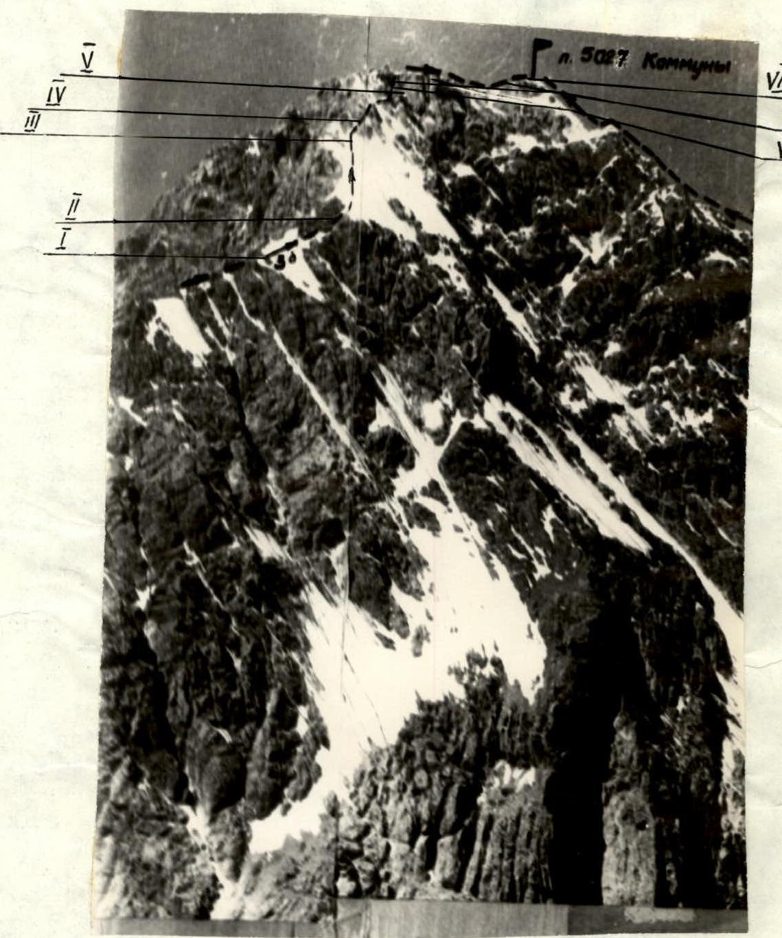
Photo 2. Western ridge of p. 5027 m
Brief description of the approach to the route:
From the base camp located at the confluence of the Kemisdykty and Koksu rivers, up the right bank of the Kemisdykty river, then cross (via rocks) to the left bank and along the AydarBek gorge to the upper camps, which are located on the right-bank moraine of the AydarBek glacier. The ascent from the base camp to the upper camps takes 2–3 hours. Elevation — 4000 m.
From the camps:
- Cross the glacier towards the scree ridge — 30 minutes;
- Then turn right along the path towards the scree couloir.
The route begins at the base of the scree couloir. Further passage of the route is described in Appendix 2.
Descent from the summit in the direction of the saddle of the southern ridge, then along the scree "black" ridge via the couloir to the AydarBek glacier. Descent time from the summit to the base camp is 4–5 hours.
The route corresponds to difficulty category — 3B.
Leader Appendix 2
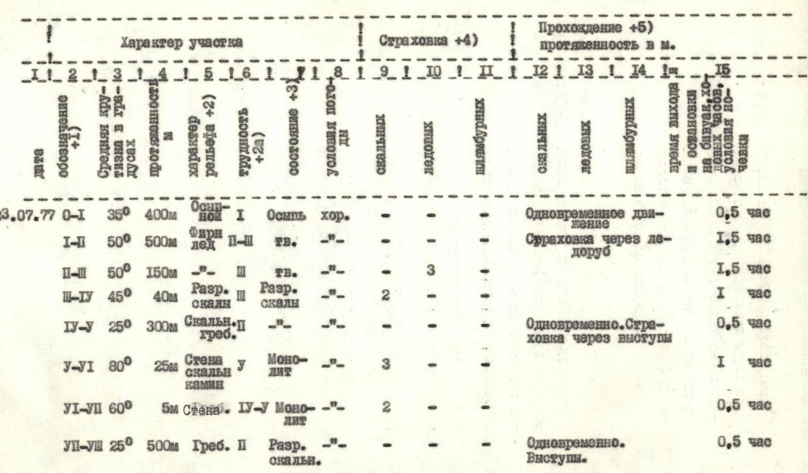
Brief explanation for the table (Appendix 2)
Section R0–R1
Scree couloir with rock islands. Average steepness 35°. Proceed along the right side under the rocks.
Section R1–R2
Upper part of the couloir — snow slope, steepness up to 50°, icy in the upper part. Exit to the snow-ice saddle of the SE ridge.
Section R2–R3
- Snow-ice slope with average steepness 50°.
- In the upper part, 40 m of ice.
- 3 ice screws.
Section R3–R4
Exit to the rocky ridge 40 m, average steepness 45°, piton belay, 2 rock pitons. Broken rocks. Many loose rocks.
Section R4–R5
Movement along the ridge. Small gendarmes are bypassed on the left along the path, 40 m. Inner corner 6 meters is climbed using free climbing. Belay through outcrops. Many loose rocks! Exit to the adjacent ridge saddle under the wall.
Section R5–R6
Wall 15 meters, chimney 10 meters. Average steepness 80°. Monolithic rocks with good holds, piton belay. The wall is climbed: 5 m up, then diagonal crack left-up. Chimney, right-up, is overcome using chimney technique 10 m. Exit to a steep snow patch to the right of the rocky fin.
Section R6–R7
Steep snow ridge. Proceed on the left side of the ridge. Belay through ice axe. 20 m, then wall 5–6 m, steepness 60°, is overcome using free climbing with piton belay (2 pitons) and exit to a small gendarme.
Section R7–R8
Further, a gentle, broken rocky ridge follows. Gendarmes and separate rocks on the ridge are bypassed on the right along the path. Movement — simultaneous.