I. Category of ascent: technical
- Area of ascent: Pamir-Alai, Southern spurs of the Alai Ridge, Kemisdikty glacier area.
- Peak, its height, ascent route: Koltsova peak, Main summit, 4824 m, East wall.
- Difficulty category: 5B.
- Route characteristics: the route is combined, height difference 924 m, including 700 m of wall section. Length of sections 5–6: 515 m, total route length 1625 m. Average steepness of the East wall 78°.
- Pitons driven (for belay / for hanging): rock 96/16, heavenly 0/11, bolt 1/0, chocks 16/17.
- Number of climbing hours: 31 hours.
- Number of bivouacs and their characteristics: 2 sitting bivouacs.
- Full name of the leader, participants and their qualification: Nikolaychuk Oleg Leonidovich — Candidate Master of Sports, Ufimtsev Vladimir Dmitrievich — Candidate Master of Sports.
- Team coaches: Bolizhevsky Valery Konstantinovich — Master of Sports of the USSR, Senchina Vyacheslav Vladimirovich — Master of Sports of the USSR.
- Date of departure and return: July 12, 1981 — July 14, 1981.
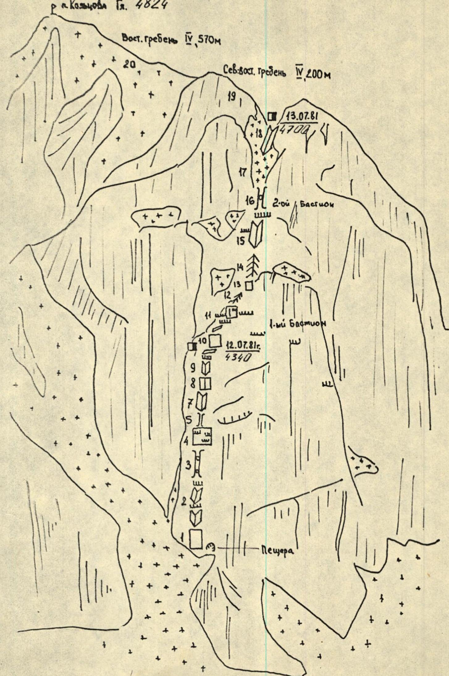
Route sketch
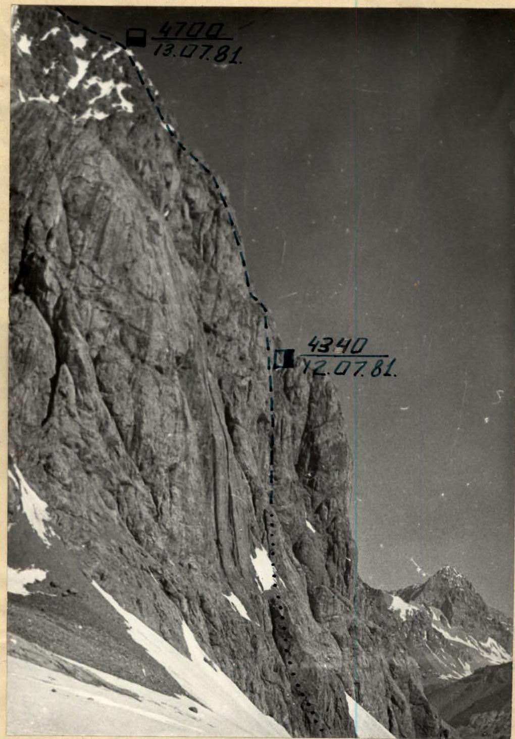
Photo 3. Route profile.
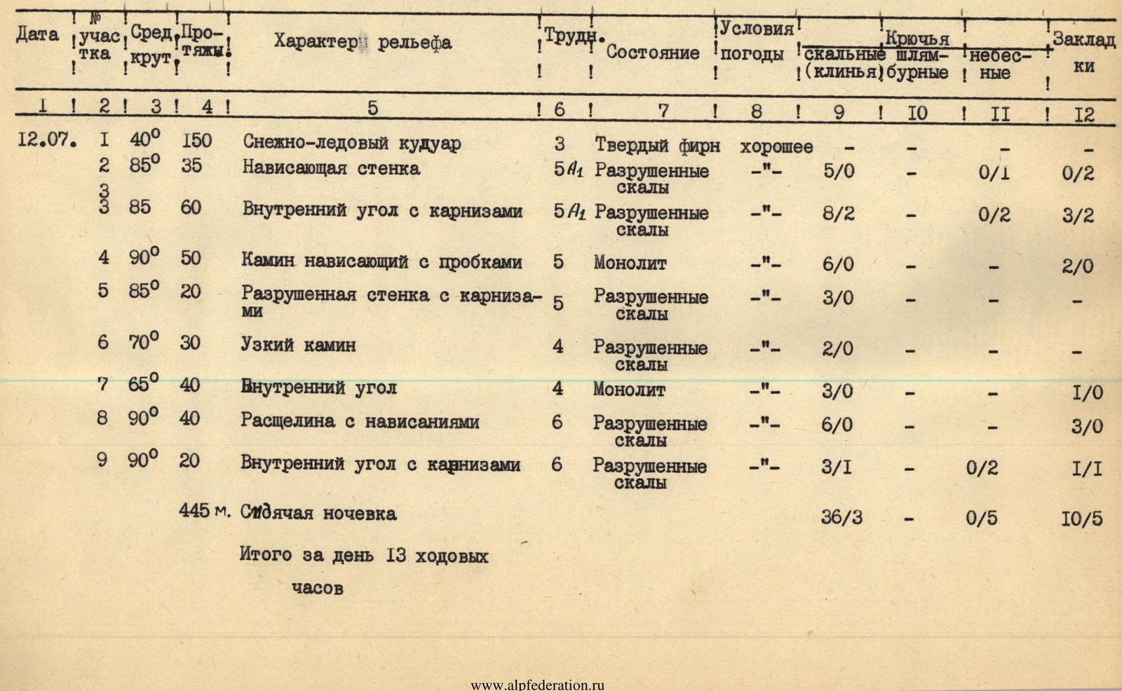
TABLE OF MAIN CHARACTERISTICS OF THE ROUTE TO PIK KOLTSOVA, MAIN SUMMIT, VIA THE EAST WALL, FIRST ASCENT (approximately 5B category of difficulty)
| Date | Section | Avg. steep. | Length | Terrain characteristics | Cat. diff. | Condition | Weather conditions | Rock (belay) | Bolt | Heavenly | Chocks |
|---|---|---|---|---|---|---|---|---|---|---|---|
| July 12, 1981 | R1 | 40° | 150 m | Snow-ice couloir | 3 | Hard firn | good | — | — | — | — |
| R2 | 85° | 35 m | Overhanging wall | 5 | Destroyed rocks | — | 5/0 | — | 0/1 | 0/2 | |
| R3 | 85° | 60 m | Inner corner with cornices | 5 | Destroyed rocks | — | 8/2 | — | 0/2 | 3/2 | |
| R4 | 90° | 50 m | Overhanging chimney with jams | 5 | Monolith | — | 6/0 | — | — | 2/0 | |
| R5 | 85° | 20 m | Destroyed wall with cornices | 5 | Destroyed rocks | — | 3/0 | — | — | — | |
| R6 | 70° | 30 m | Narrow chimney | 4 | Destroyed rocks | — | 2/0 | — | — | — | |
| R7 | 65° | 40 m | Inner corner | 4 | Monolith | — | 3/0 | — | — | 1/0 | |
| R8 | 90° | 40 m | Cleft with overhangs | 6 | Destroyed rocks | — | 6/0 | — | — | 3/0 | |
| R9 | 90° | 20 m | Inner corner with cornices | 6 | Destroyed rocks | — | 3/1 | — | 0/2 | 1/1 | |
| 445 m. Sitting bivouac | |||||||||||
| Total for the day 13 climbing hours | 36/3 | — | 0/5 | 10/5 | |||||||
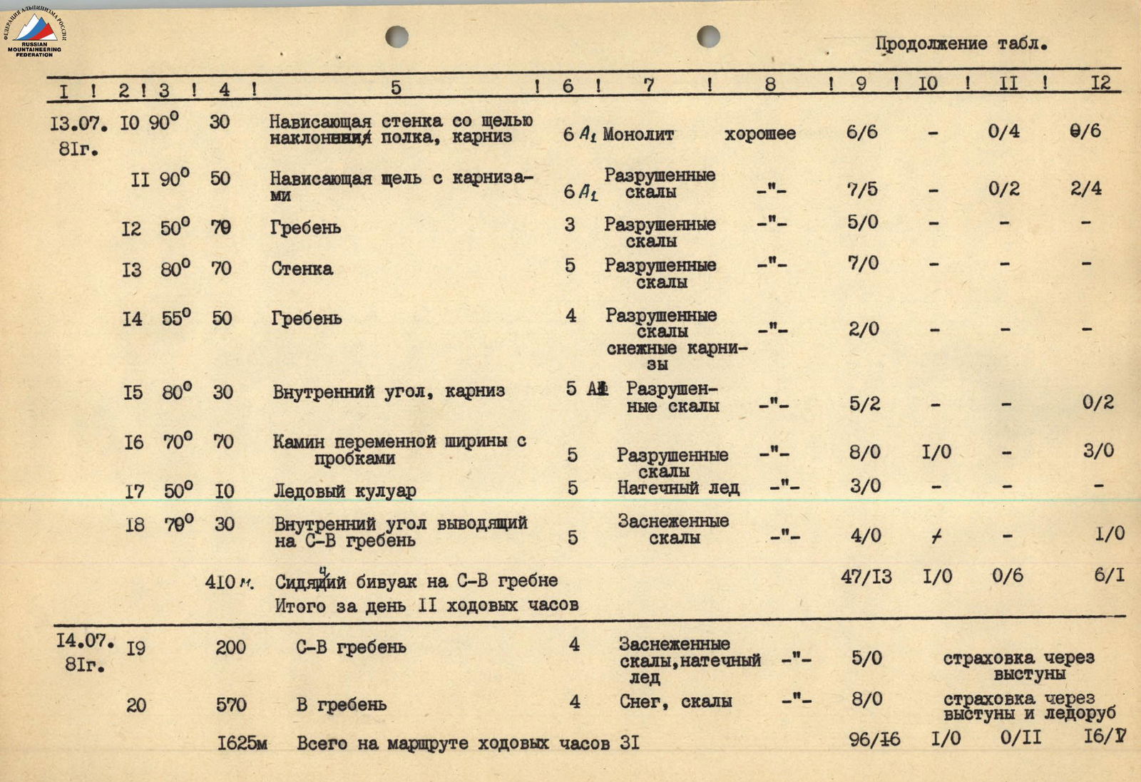
| July 13, 1981 | R10 | 90° | 30 m | Overhanging wall with a slot, | 6 | Monolith | good | 6/6 | — | 0/4 | 0/6 |
| slope of the ledge, cornice | |||||||||||
| R11 | 90° | 50 m | Overhanging cleft with cornices | 6 | Destroyed rocks | — | 7/5 | — | 0/2 | 2/4 | |
| R12 | 50° | 70 m | Ridge | 3 | Destroyed rocks | — | 5/0 | — | — | — | |
| R13 | 80° | 70 m | Wall | 5 | Destroyed rocks | — | 7/0 | — | — | — | |
| R14 | 55° | 50 m | Ridge, snow cornices | 4 | Destroyed rocks | — | 2/0 | — | — | — | |
| R15 | 80° | 30 m | Inner corner, cornice | 5 | Destroyed rocks | — | 5/2 | — | — | 0/2 | |
| R16 | 70° | 70 m | Chimney of variable width with jams | 5 | Destroyed rocks | — | 8/0 | 1/0 | — | 3/0 | |
| R17 | 50° | 10 m | Ice couloir | 5 | Congealed ice | — | 3/0 | — | — | — | |
| R18 | 70° | 30 m | Inner corner, leading | 5 | Snow-covered rocks | — | 4/0 | + | — | 1/0 | |
| to the NE ridge | |||||||||||
| 410 m. Sitting bivouac on the NE ridge | |||||||||||
| Total for the day 11 climbing hours | 47/13 | 1/0 | 0/6 | 6/12 | |||||||
| July 14, 1981 | R19 | — | 200 m | NE ridge | 4 | Snow-covered rocks, | — | 5/0 | — | — | — |
| congealed ice | belay via ledges | ||||||||||
| R20 | — | 570 m | Along the ridge | 4 | Snow, rocks | — | 8/0 | — | — | — | |
| belay via ledges and ice axe | |||||||||||
| 1625 m Total on the route 31 climbing hours | 96/16 | 1/0 | 0/11 | 16/17 |
Brief explanation for the table of main characteristics
July 12, 1981
We leave the bivouac under the peak Tekelek at 6:00. We quickly cross the Kemisdikty glacier. We put on crampons and, on hard firn, following the right side of the large couloir of the East wall of Koltsova peak, we approach the base of the route.
Here, on a narrow scree ledge:
- we tie in;
- repack our backpacks.
From below, it is already visible that the first climber must go without a backpack and on a double rope. The route starts to the left of a small cave, from a protruding rock, in the direction of the inner corner.
The first wall immediately overhangs. We have to use two chocks and one heavenly piton as TAE.
Despite the great steepness, the rocks are destroyed, and we have to move very cautiously. We reach the base of the inner corner with cornices. There are no ledges here, and we have to organize belay, sitting in a harness. Further — along the inner corner to the overhanging chimney. Climbing is complex but pleasant here. The chimney walls are made of monoliths and, despite frequent jams that have to be passed, crawling outwards, this section leaves a good impression. The chimney leads to a destroyed 20-meter wall, the upper part of which is covered by a cornice.
We pass this section with free climbing, and then the steepness of the wall decreases somewhat. A narrow chimney, turning into an inner corner, leads to an overhanging section. We pass the vertical wall with live rocks and blocks, first along a cleft, and then along an overhanging inner corner. Here is a small ledge. It's already 18:00, and we decide to organize a bivouac here. But there is time, and we process another rope length straight up from the ledge.
July 13, 1981
We leave at 7:30. We quickly pass the processed section and come up against an overhanging wall, the passage of which takes more than four hours. This is the key section of the route. The overhanging cleft is passed:
- partially with TAE;
- partially with free climbing.
The rocks are destroyed, and utmost caution is required. Finally, having overcome the last cornice, we reach a small ridge, after passing which, we come up against a wall. We pass the wall with free climbing and, having passed the next ridge, we reach the last bastion, along which:
- first along rocks;
- then crossing an ice couloir;
- along the inner corner — we reach the North-East ridge.
Here is a bivouac.
July 14, 1981
We leave at 7:00 and quickly reach the East ridge along the North-East ridge. Here the movement slows down, cornices hang both to the north and to the south, so we have to move very cautiously, and the snow is slushy and holds very poorly. We organize belay mainly on rocks. But now the difficult part is over, and we are on the summit. The descent to the south, first along a wide, then narrowing couloir, to the Kemisdikty glacier took us 2 hours.