- Climbing class — technical
- Climbing area, ridge — Alai Ridge, Pamir-Alai
- Peak, its height, ascent route: peak Aidarbek, 5127 m, via the North Ridge
- Proposed difficulty category: 5A cat. diff.
- Route characteristics:
- elevation gain: 100 m
- length of sections with 5–6 cat. diff.: 250 m
- average steepness: 55°
- Pitons hammered: for belaying, for creating IC:
- rock — 23
- ice — 32
- bolt — 0
- Number of walking hours — 22
- Number of nights and their characteristics:
- one overnight, lying down
- Surname, name, patronymic of the leader, participants and their qualifications:
- Korenyugin Igor Konstantinovich
- Bubynin Leonid Vasilyevich
- Boev Yuri Nikolayevich
- Yanin Vyacheslav Artemyevich
- Team coach: Zaev E.F.
- Date of departure and return:
- Departure — August 4, 1977 at 5:00
- Return — August 5, 1977 at 20:00

Photo-scheme
Ascent Description
The ascent was made with overnight stays located on the right (orographic) side of the Aidarbek glacier, an hour's walk from the start of the route and 2.5 hours from the base camp of the Alai tourist camp, located at the confluence of the Kok-Su and Kemizdykty rivers.
R0–R1. From the overnight stay, cross the glacier towards the North Ridge on Aidarbek. The exit to the ridge is via an oblique snowy scree shelf with a steepness of 20–25°.
R1–R2. Further, along the destroyed rocks of medium difficulty, exit under the red wall, 20–25 m.
R2–R3. Up the wall to the left, then up to the right along the shelf to the gentle part of the ridge. Belaying with pitons. Further along the rocks of medium difficulty and above medium difficulty, exit under the ice ridge.
R3–R4. Steep ice ridge 50–55° is overcome with crampons and piton belaying.
R4–R5. Further along the difficult, heavily destroyed rocks in the direction of the snowy col under the ice wall 10–15 m, which is overcome with the help of pitons. Exit to the snowy col. Here is a platform. Overnight stay is possible.
R5–R6. Along the snowy ridge, exit under the 1st rise of the ridge, which is passed along the ice-covered rocks, initially head-on, then bypassing to the left.
R6–R7. The second rise is a rock wall 8–10 m, which is passed in the same way, initially head-on, and then exiting to the right.
R7–R8. The third rise is an ice wall 15 m steepness 75–80°. Passed head-on with artificial points of support (ice screws, pitons).
R8–R9. The fourth rise is a rock bastion 18–20 m, passed head-on on the left part.
R9–R10. The fifth rise is rock-ice 35–40 m steepness in the upper part 80–90°. Initially passed to the right along the ridge, then swinging left to the rocks and along them under the ice wall of the pre-summit ice ridge.
R10–R11. Ice pre-summit ridge steepness 45–50°. R11–R12. Destroyed simple rocks lead to the summit.
The group assesses the complexity of the route taken — 5A cat. diff.
ASCENT LEADER Korenyugin.

Belaying
Passage and Length
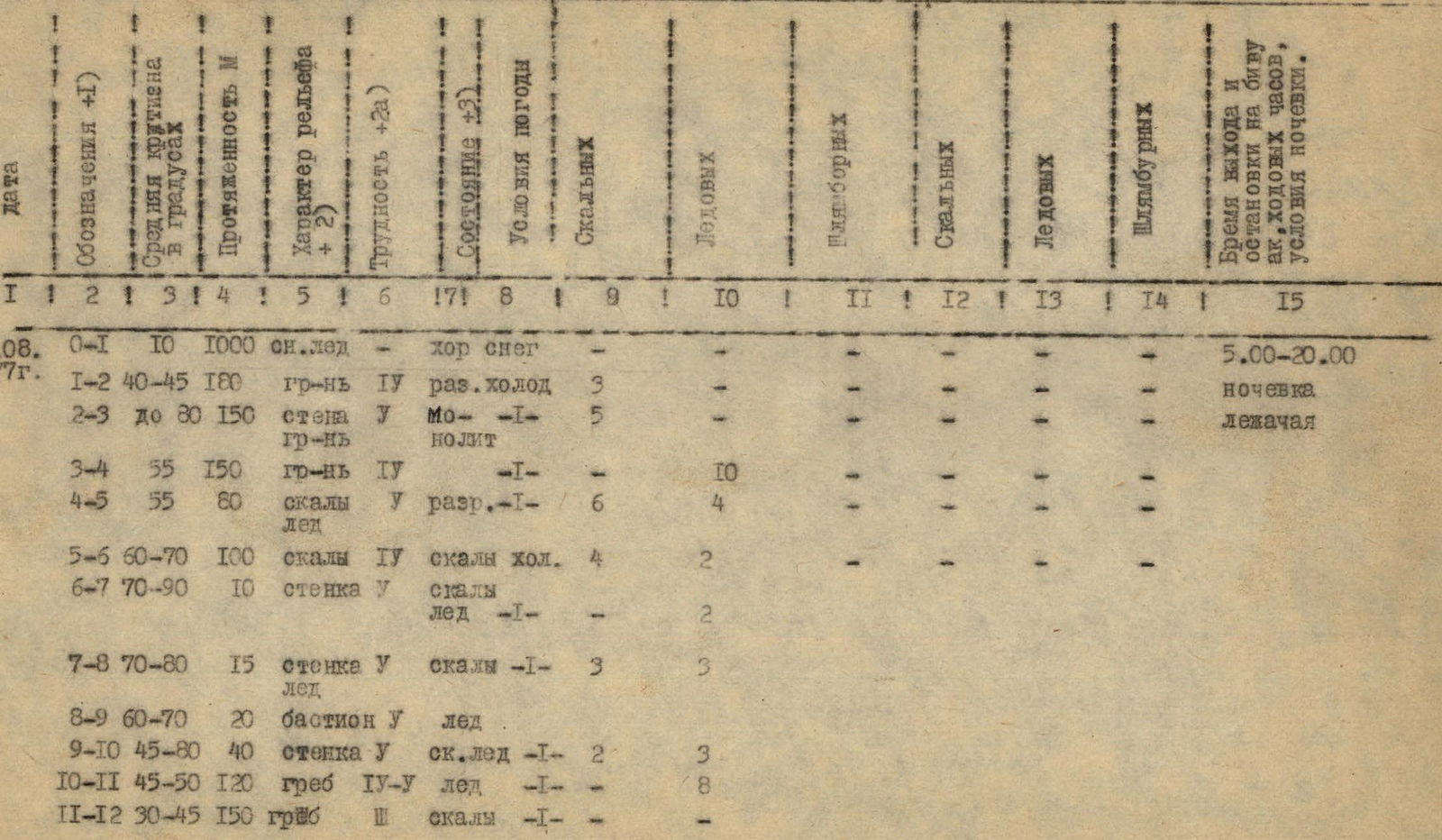
| SECTION CHARACTERISTICS | BELAYING | PASSAGE (+5) LENGTH in m. |
|---|---|---|
| Date: 4.08.1977 | Conditions: | |
| Section R0–R1 | Steepness: 10 | Length: 1000 m. Terrain: Snow-ice. Difficulty: good snow. Time: from 5:00 to 20:00. Overnight: lying down. |
| Section R1–R2 | Steepness: 40–45 | Length: 180 m. Terrain: rock-gr IV. Difficulty: destroyed cold. Belaying: rock — 3. |
| Section R2–R3 | Steepness: up to 80 | Length: 150 m. Terrain: wall V rock-gr. Difficulty: Mo––I–. Belaying: rock — 5. |
| Section R3–R4 | Steepness: 55 | Length: 150 m. Terrain: rock-gr IV. Difficulty: –I–. Belaying: ice — 10. |
| Section R4–R5 | Steepness: 55 | Length: 80 m. Terrain: rocks V ice. Difficulty: destroyed–I–/6. Belaying: ice — 4. |
| Section R5–R6 | Steepness: 60–70 | Length: 100 m. Terrain: rocks IV. Difficulty: rocks cold. Belaying: rock — 4, ice — 2. |
| Section R6–R7 | Steepness: 70–90 | Length: 10 m. Terrain: wall V ice. Difficulty: rocks –T–. Belaying: ice — 2. |
| Section R7–R8 | Steepness: 70–80 | Length: 15 m. Terrain: wall V ice. Difficulty: rocks –1–. Belaying: rock — 3, ice — 3. |
| Section R8–R9 | Steepness: 60–70 | Length: 20 m. Terrain: bastion V ice. |
| Section R9–R10 | Steepness: 45–80 | Length: 40 m. Terrain: wall V. Difficulty: rock-ice –I–. Belaying: ice — 2. |
| Section R10–R11 | Steepness: 45–50 | Length: 120 m. Terrain: ridge IV-V ice. Difficulty: –I–. Belaying: rock — 3, ice — 8. |
| Section R11–R12 | Steepness: 30–45 | Length: 150 m. Terrain: fungus III. Difficulty: rocks –1–. |