
Dugoba alpine camp 5.1A 105. IIIa
Report on the ascent of Pik Uzbekistan via the North-Eastern wall 1976
Protocol No. 81 from August 30, 1976, reviewing the ascent of Pik Uzbekistan, category 5B, via the NE wall, "credited".
Present: the group in full: Klyukvin S.D., leader Nespovity V.S., Okladnikov V.E., Vilde R.A., head of the training department of Dugoba alpine camp, Klimenko I.K., head of the rescue team of Dugoba alpine camp, Ekimov S.M., observers: Erofeeva O.V., Badamshina F.S., Novoselov A.G., Loginov I.V.
Klyukvin S.D.: On August 26, 1976, the group consisting of Klyukvin S.D., Nespovity V.S., Okladnikov V.E., Vilde R.A. started the route at 6:00, carrying:
- 3 ends of main rope, 40 m each
- auxiliary rope - 40 m
- 2 hammers
- a set of rock and ice pitons
- 2 pairs of crampons
- 3 ladders
- "Pamirka" tent
- 2 sleeping bags
- "Vitalka" radio station
- flares
The bergschrund and the ice section were traversed with piton protection, Klyukvin leading. From the scree shelf, we moved onto rocks of medium difficulty. After overcoming a 40 m sheer wall, the team regrouped. We reached the first control cairn by 15:00, found a note from Semenov's group from 1973, and proceeded under the chimney, with a steepness of 75-90°. Further, we encountered steep slabs with limited cracks. By 17:00, we reached a shelf suitable for a semi-reclined bivouac. Klyukvin and Nespovity processed 80 m of the route above the bivouac. On the first day, we hammered in 5 ice pitons and 70 rock pitons, with an average steepness of 75-85°.
On August 27, we started at 9:00 from the bivouac, passed two ropes hung the previous evening, and reached a rocky ridge with a gap (10 m). Further, we encountered flow ice, and the pace slowed. The most challenging sections were slab-like areas covered with flow ice. At 15:00, we had the last radio contact with observers that day. Before the summit bastion, we encountered snowy sections and destroyed rocks. By 18:00, we reached under the pre-summit tower from the left, with a good platform for a bivouac. On the second day, we hammered in 75 rock pitons, with an average steepness of 65-70°.
On August 28, we started at 8:00 and reached the summit by 10:00. The descent followed the route of category 4. By 20:00, we were at the observers' bivouac.
On the route, everyone worked reliably, I have no complaints, and this team can tackle a route of similar difficulty. I liked the route and believe it meets the requirements for a "credited" ascent.
Nespovity V.S.: The leader coped with his duties, the team was great, and we completed the route competently and without incidents.
Klimenko I.K.: The ascent and leadership are credited.
Ekimov S.M.: I agree with the participants and the leader - the ascent and leadership are credited; the observers performed their duties very clearly and conscientiously.
The protocol was kept by Vilde R.A. (signature) Head of the rescue team, Ekimov S.M. (signature)
I certify the copy of the review, Head of the training department of Dugoba alpine camp, V. Yakovlev
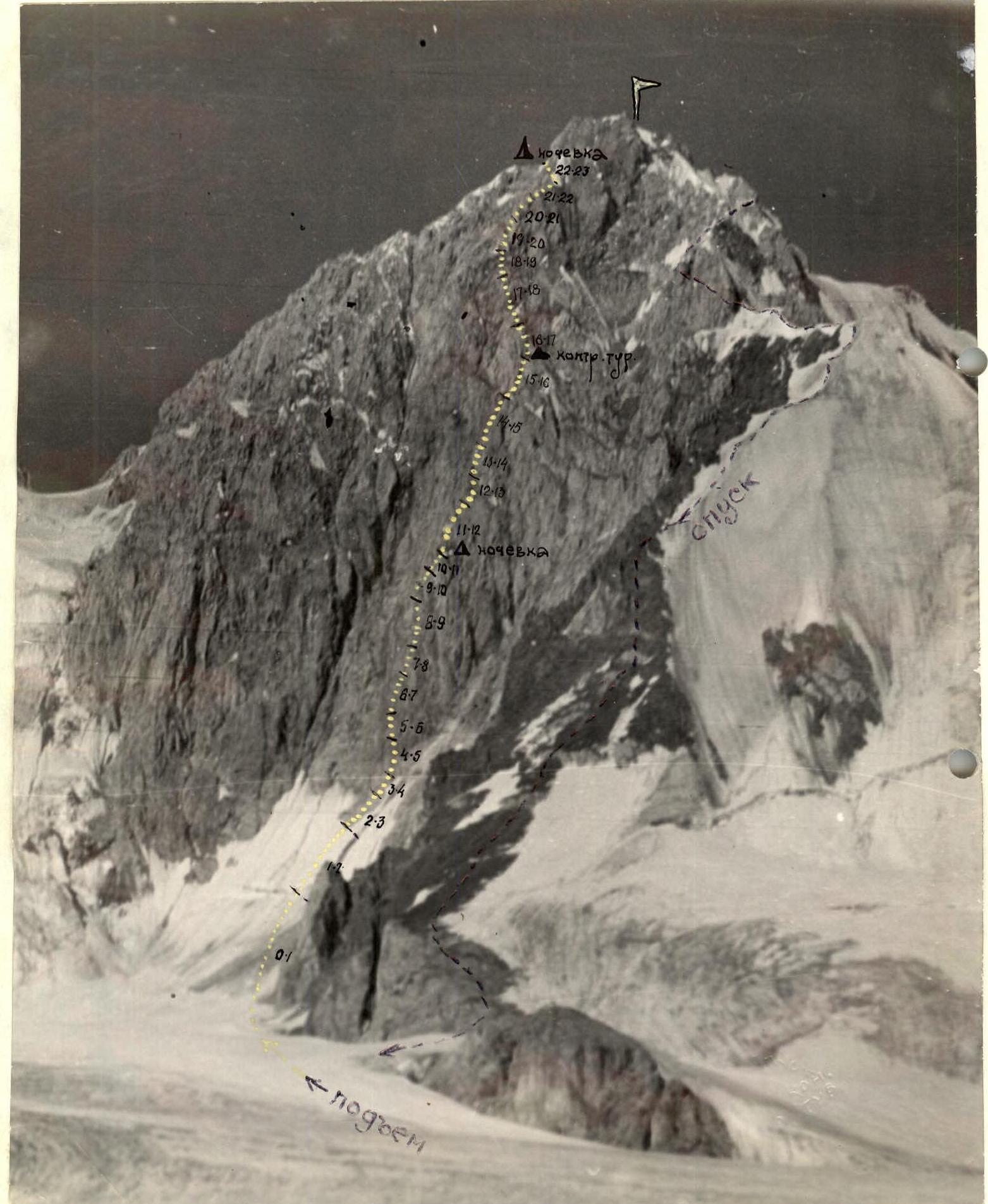
Brief explanation of the table
From the observers' camp, located on the Dugoba glacier, we departed on August 26, 1976, at 6:00. We approached the start of the route at 6:30. The R0-R1 section - a snow-firn slope, traversed simultaneously, presented no particular difficulties. The R1-R2 section.
From the bergschrund, which is crossed via a snow bridge, two ropes traverse an ice slope to a rocky outcrop, with possible rockfall. The R2-R3 section.
Through the rocky outcrop and an icy saddle, along destroyed rocks to a rock wall. The R3-R4 section.
A 40 m wall. Climbing is very difficult, using artificial aids. The R4-R5 section.
A rocky slope with a transition under a moderately expressed inner corner. The R5-R6 section.
After the inner corner - movement along an overhanging wall. Use of artificial aids. Climbing is very difficult. The R6-R7 section.
A smooth, slab-like wall with a minimal number of holds. We transition into an overhanging chimney. The R7-R8 section.
An overhanging chimney with nearly smooth walls. Progress is extremely difficult. Use of artificial aids. The R8-R9 section.
Traversing a moderately expressed ridge with a gap, which leads to a second chimney in an inclined wall. The R9-R10 section.
A moderately expressed inner corner. The R10-R11 section.
An icy couloir, transitioning into a chimney with a plug. Bivouac (with snow for water), a platform for a semi-reclined bivouac. The R11-R12 section.
An overhanging wall with a minimal number of cracks for pitons. The R12-R13 section.
Exit via an inner corner onto a wall with a cleft, leading to a ridge-like outcrop. The R13-R14 section.
A slab-like wall with a cornice. Use of ladders. The R14-R15 section.
An inclined shelf leading into a couloir, filled with snow and ice. The R15-R16 section.
The couloir leads to a wall, traversed from the right, and ends at a control cairn. The R16-R17 section.
A couloir transitioning into a chimney with a plug, filled with snow and ice. Rockfall hazard. The R17-R18 section.
A wide couloir, covered with flow ice. The R18-R19 section.
"Ram's foreheads". Very limited number of convenient cracks for pitons. Use of artificial aids. The R19-R20 section.
A wall with an overhanging shelf. Climbing is very difficult. The R20-R21 section.
A wall with red rocks, traversed via an inner corner. Encountered flow ice. The R21-R22 section.
Exit onto a moderately expressed ridge, transitioning into a snow-ice slope. The R22-R23 section.
A slope transitioning into a narrow ridge with a gendarme. Direct ascent. Bivouac. Good and safe platform. The R23-R24 section.
The wall of the summit tower, traversed left and upwards. Rockfall hazard. The R24-R25 section.
The pre-summit ridge, heavily destroyed. Protection via outcrops. Exit to the summit.
Comments
Sign in to leave a comment