Ascent Passport
I. Category of technically complex ascents 2. Pamir-Alay. Alay Ridge. Podkova Kosmonavtov. 3. Titov Peak (approximately 4800 m) via the northern counterfort. 4. 4B category of difficulty. 5. Route characteristics: a) height difference 700 m; b) length of section with IV–V category of difficulty 350 m; c) average steepness 53°. 6. Pitons hammered for belay and creating ITO: a) rock pitons 20; b) ice screws ВЦСПС II; c) ice drilling pitons 3. 7. Number of climbing hours — 14. 8. One overnight stay in a tent. 9. Head of the ascent II sports category in mountaineering. I sports category in rock climbing. Toropchin V.I.
Ascent participants
- Koragodin II sports category in mountaineering, II sports category in rock climbing.
- Volkova I sports category in mountaineering, II sports category in rock climbing.
- Team coach — senior instructor MS Saprykin V.D.
- Date of departure on the route — August 7, 1977.
Return to base camp — August 8, 1977.
Route progression
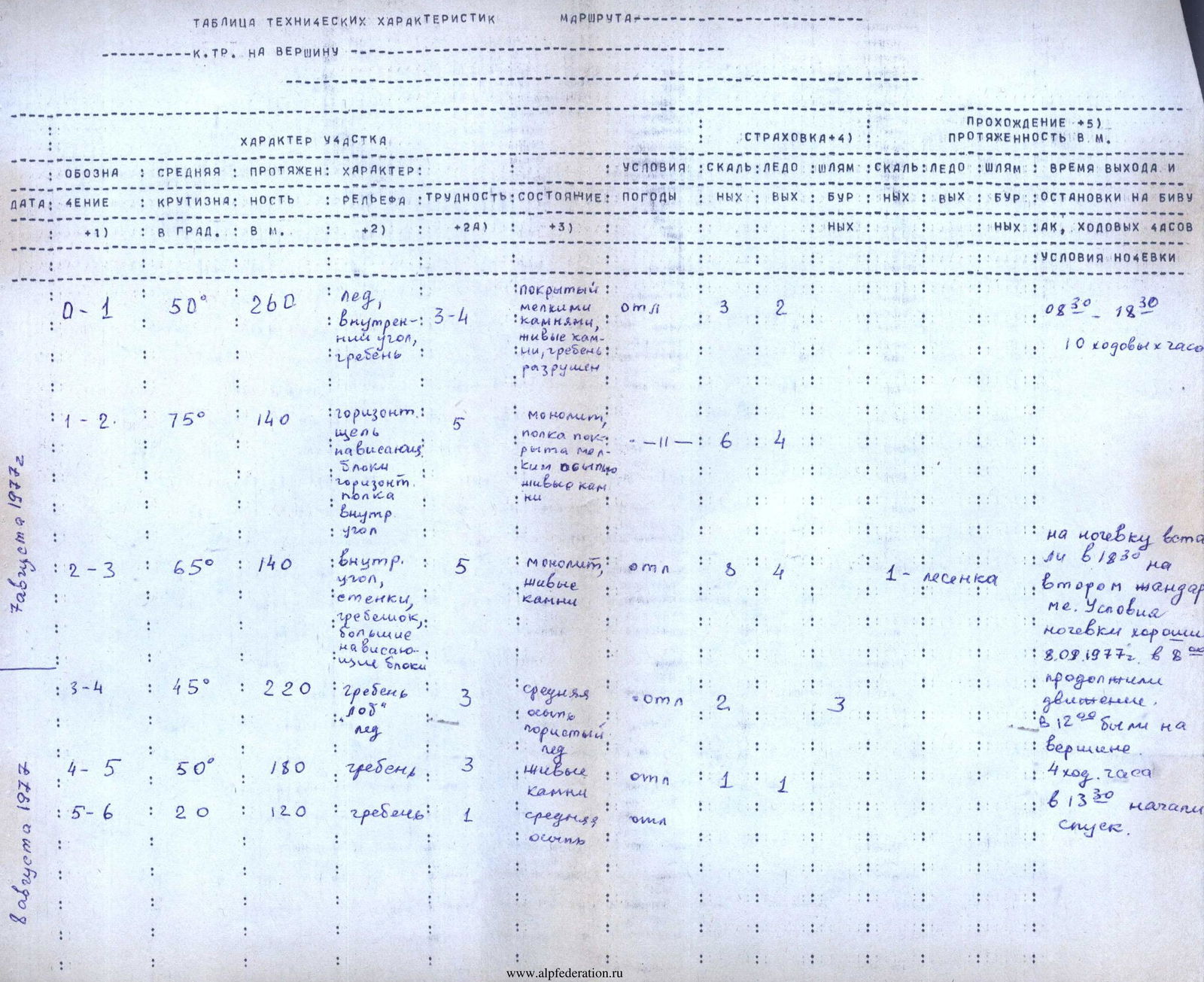
Day one: On August 7 at 7:00 the group left the camp. At 8:30 they were under the route. By 18:30 they were at the top of the second gendarme.
Day two: On August 8 at 8:00 the group left the bivouac and started on the route. Having passed the second half of the route, by 12:00 they reached the summit. They retrieved a note left by climbers from SAVO led by Skachkov, who had traversed "Podkova" in 1970. The descent was made via the ascent route. They arrived at the base camp at 20:00.
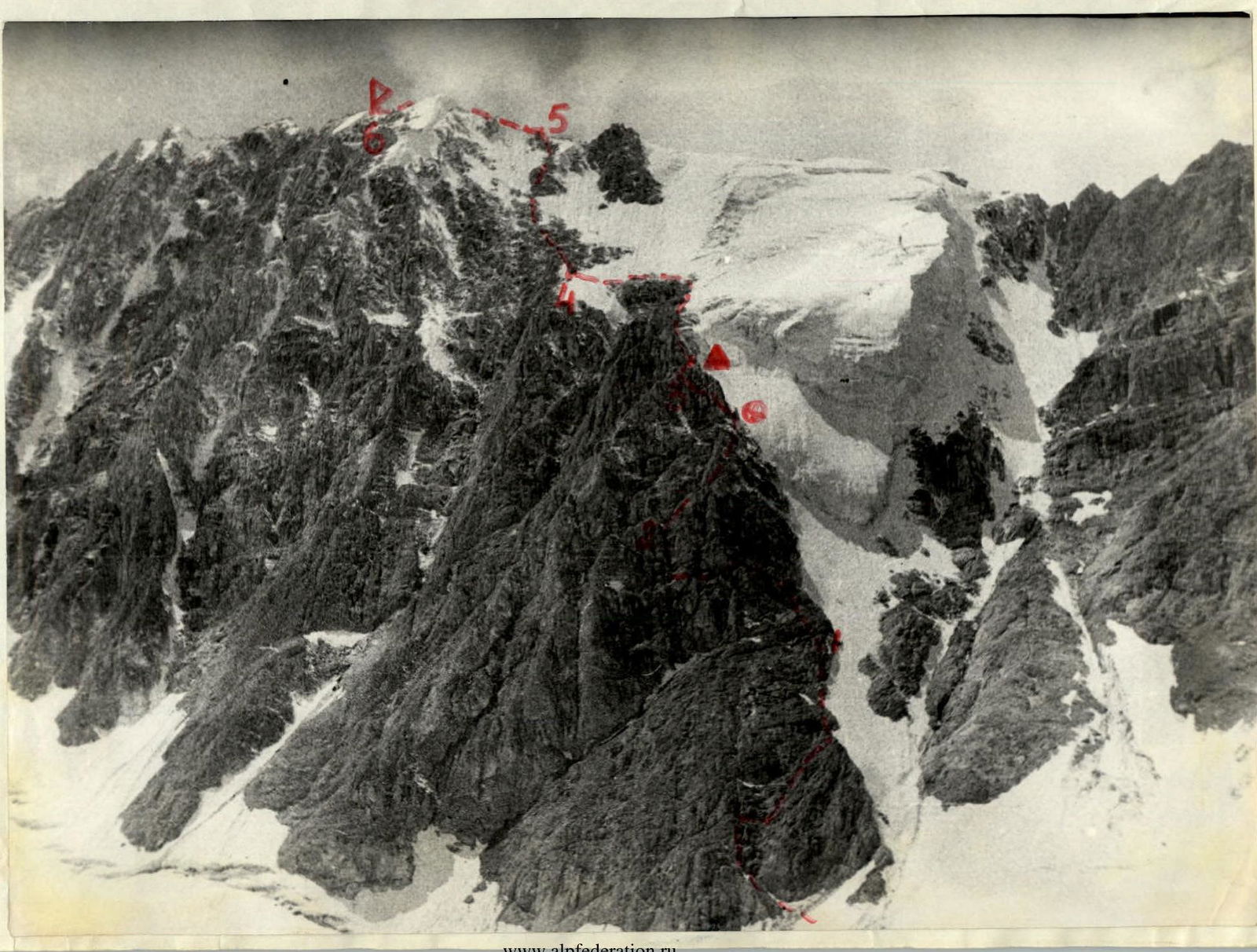
Route
Route description
The route is clearly visible from l. Kosmonavtov as a counterfort passing along the serac zone on the right part of Titov Peak, leading to a snowy tower on the summit ridge.
From the overnight stays located on the right lateral moraine of the Kosmonavtov Glacier to the start of the route — 1.5 hours.
Section R0–R1: Crossing the glacier to approach the snow-ice slope. Ascent up the steep snow-ice slope made of dense snow with ice. The bergschrund is bypassed on the right.
Crossing two couloirs (rockfall!), ascent to the base of the counterfort. The base of the counterfort is divided into two indistinctly expressed ribs by an internal angle. Ascent up the left part of the diverging talus.
On the left side of the internal angle — 35 m straight up the rocks of medium complexity. Then to the right along the talus shelves, overcoming small walls, we reach the ridge of the counterfort.
Along the ridge — 160 m, simultaneously, with occasional belays using protrusions for protection; ascent to a small talus shelf under a reddish wall with black streaks.
Section R1–R2. Along a smooth 15-meter wall with limited handholds. Ascent under overhanging blocks, which are climbed directly. 5–6 meters before a distinctly red belt — a negative section. Climbing is complex. Backpacks are pulled up. Then along a 0.5 m wide talus shelf, traverse left for 60 m. The shelf abuts a rock protrusion. Bypassing the rock protrusion on the left along the internal angle left — up 15 m, complex climbing (deviates left). Then along the wall with good handholds, exit to a small talus shelf, convenient for belay. Section R2–R3. From the shelf 35 m along the internal angle, transitioning into a chimney, movement right-up, using friction for climbing. Then along the destroyed rocks to a smooth 12 m wall with an overhanging upper part. The wall is climbed directly along a crack, using jamming of hands and feet. The wall is smooth on both sides. Only at the top is it possible to find a crack for a leaf-shaped piton, which is hammered in a very uncomfortable position. A ladder is hung on the piton. Climbing is very complex. Backpacks are pulled up. Then movement left — up along the internal angle through an overhanging rock to the top of the first gendarme. A control cairn is established here. From the cairn along a loose connecting ridge under the wall, which is passed right-to-left (diagonally). The start of the movement is through a 4-meter sheer wall with limited handholds, then along an inclined talus shelf — under overhanging rocks covered with ice. Through them, exit to a narrow shelf, along which traverse left — 4 m through a rock-ice gully under a large overhanging rock. To the left of the large overhanging rock straight up along the reddish internal angle to the top of the second gendarme. We set up a tent on a convenient and safe site. Section R3–R4. From the bivouac 120 m up along the serac zone along destroyed rocks and medium talus under the black "ram's forehead". Exit to the last ice slope on the right at 60° in crampons. Traversing left 45° along the glacier (rockfall hazard in the middle of the day), we exit to the rock ridge branching off between the snowy and reddish gendarmes of the summit ridge. Section R4–R5. Along the rock ridge simultaneously, with occasional belays, exit to the summit ridge. Section R5–R6. Along the ridge, bypassing two gendarmes, exit to the summit. The group descended from the summit in 6.5 hours via the ascent route.
A second descent option is via the southern ridge of Titov Peak to l. Levin. To return to the Kosmonavtov valley, one can go through the Kosmonavtov Pass or the Devyat Pass.


