Ascent Passport
I. Category of First Ascent
-
Pamir-Alay, Alay Ridge, Sauk-Jaylau gorge
-
Sauk-Jaylau Main (5120 m) via North face
-
Estimated difficulty category — 6B cat. diff.
-
Route characteristics: height difference — 1220 m route length — 1312 m length of sections with 5–6 categories — 900 m average steepness of the main part of the route — 62° average steepness of the central part of the wall — 80°
-
Pitons driven:
| rock | bolt | ice | chocks | |
|---|---|---|---|---|
| for belay | 59 | 3 | 75 | 45 |
| for I.T.O. | 33 | 3 | 7 | 34 |
- Team's climbing hours 76
- Overnight stays: 7 hanging, 1 lying on the summit
- Captain: Krasnukhin Leonid Ivanovich CMS Team members:
- Afanasyev Andrey Evgenyevich CMS
- Karataev Vladimir Alexandrovich CMS
- Lebedev Vyacheslav Georgievich CMS
- Yakovenko Alexander Nikolayevich CMS
- Team coach: Mikhailov Andrey Andreyevich MS USSR
- Date of departure on the route and return:
June 15, 1984
June 23, 1984
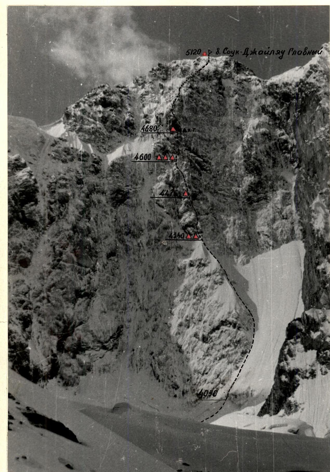
Photo of the wall profile on the right
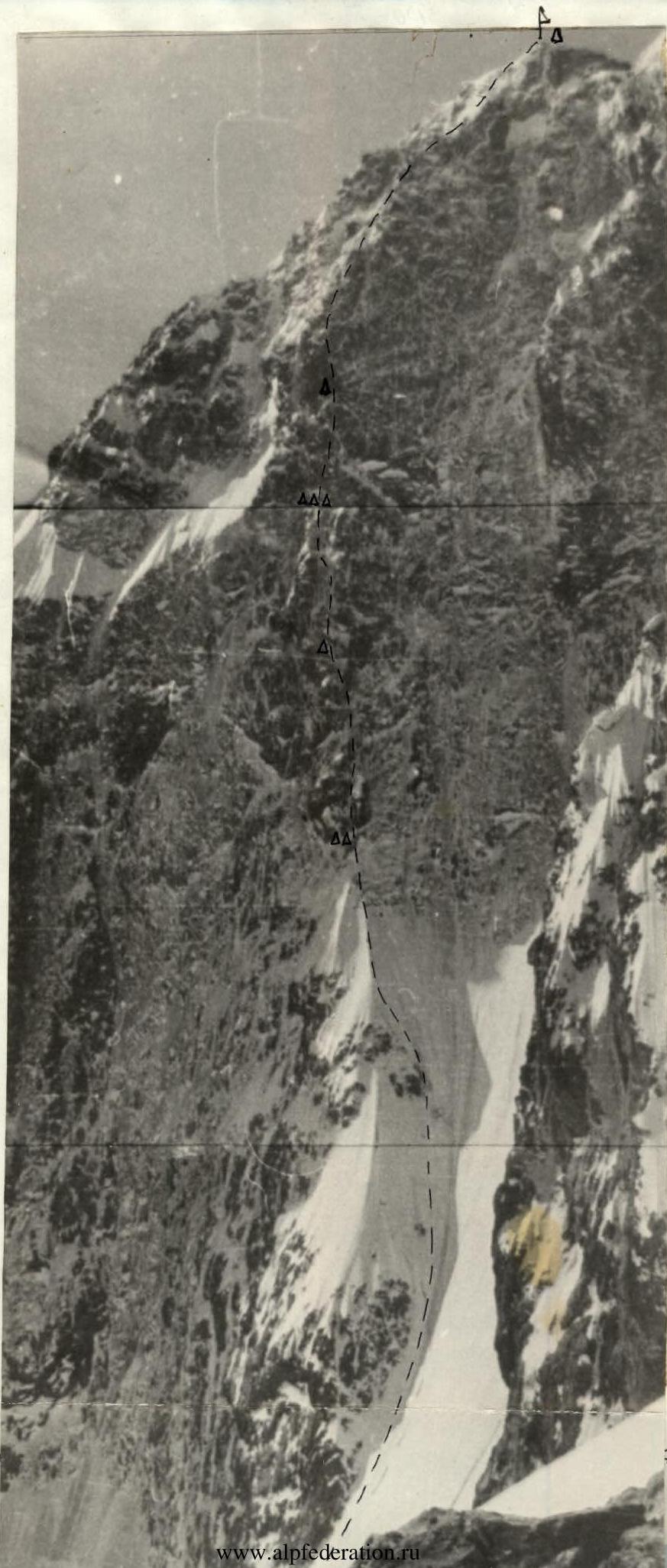
Photo of the wall profile on the left
Sauk-Jaylau Main 5120 m
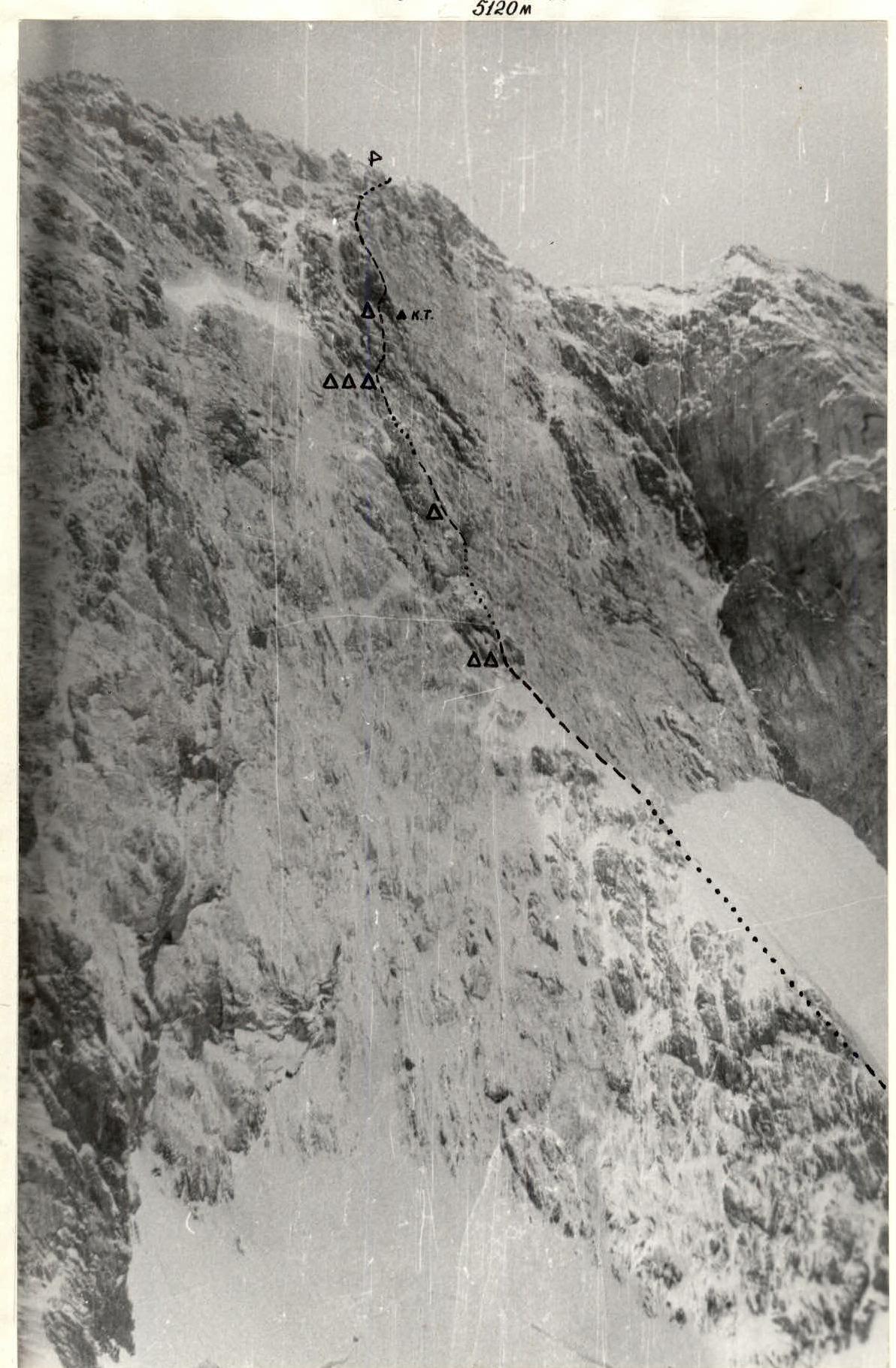
Photo #2 3900 m, June 1984
- Lens type — Industar 50
- Focal length: 52
- Shooting point: #2
- Distance to the object: 1500 m
Photopanorama of the area
V. SAUK-DZHAYLAU Main 5120 m
VV. SAUK-DZHAYLAU Central 5225 m
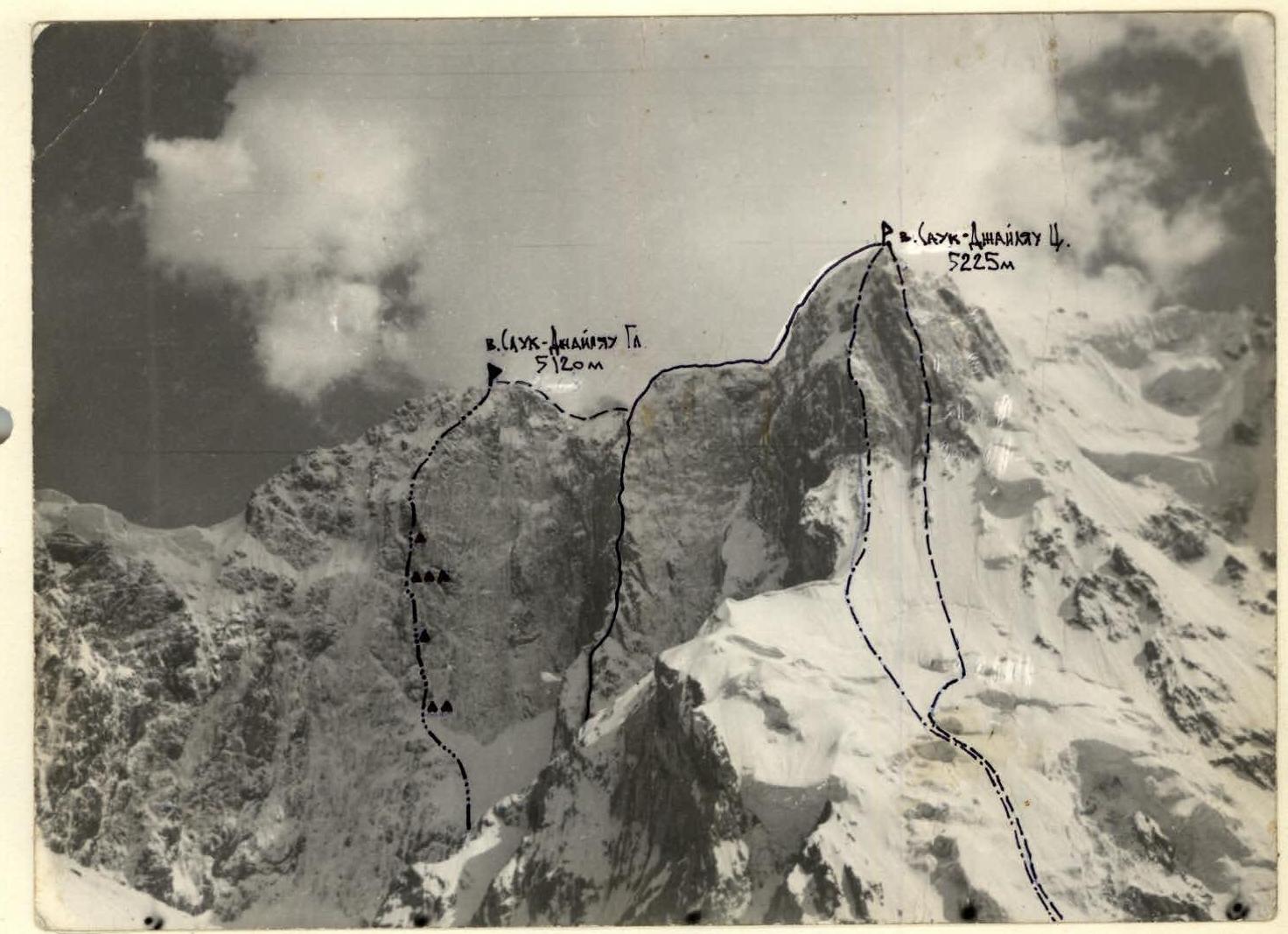
Photo #3 Lens type — Industar 50, focal length 52. Shooting point #5, distance to the object 4 km
- Kovtun's route
- Moskaltsov's route
- Staroselts' route
- Route of the team from the Irkutsk Regional Sports Committee
Brief overview of the ascent area
The Sauk-Jaylau mountain massif is located in the northern spur of the Alay Ridge between the Topon and Sauk-Jaylau gorges — a right tributary of the Archa-Kanysh gorge.
Access to the Archa-Kanysh gorge is from the city of Kyzyl-Kiya, through the settlement of Uchkurgan and Maidan along the road to Daraut-Kurgan to the "Chaykhona", then to the Mileksu mine. From the Mileksu mine, it takes 2 hours to reach the base camp in the "Poplar grove". In the Archa-Kanysh gorge, a branch of the "Dugoba" alpine camp — the "Archa-Kanysh" camp has been functioning for many years. Up the canyon, a steep ascent (5 hours) leads to the North circus of Sauk-Jaylau. The Sauk-Jaylau circus has a glacier, the level of which is 3800 m under the walls of the peak. The North face of Sauk-Jaylau Main is the longest and coldest wall of the massif, with a direct, logical, and safe route visible through its center.
The rocks forming the Sauk-Jaylau massif belong to the metamorphic group, with a predominance of granites. The rocks are generally monolithic, strong, but there are individual sections with heavily destroyed rock. Destroyed blocks are frozen with ice and generally represent strong, frozen monoliths.
The development of the massif began in 1977. Routes were climbed on Sauk-Jaylau (4B cat. diff.) — East and (5A cat. diff.) — Southeast. In subsequent years, routes of the highest category were climbed on the Central peak, one of which took third place at the USSR championship (Kovtun's route). Attempts were made to climb the Main peak via the North face. But it remained unconquered until 1984.
The wall is steep, with diverse ice-rock relief. But despite the variety of relief, there is not a single ledge suitable for organizing overnight stays with standard bivouac equipment along the route, which was a certain obstacle for previous groups to climb this route. Our team, having thoroughly studied the Sauk-Jaylau massif and prepared accordingly for the specific climbing conditions, climbed this route at the most favorable time of the year.
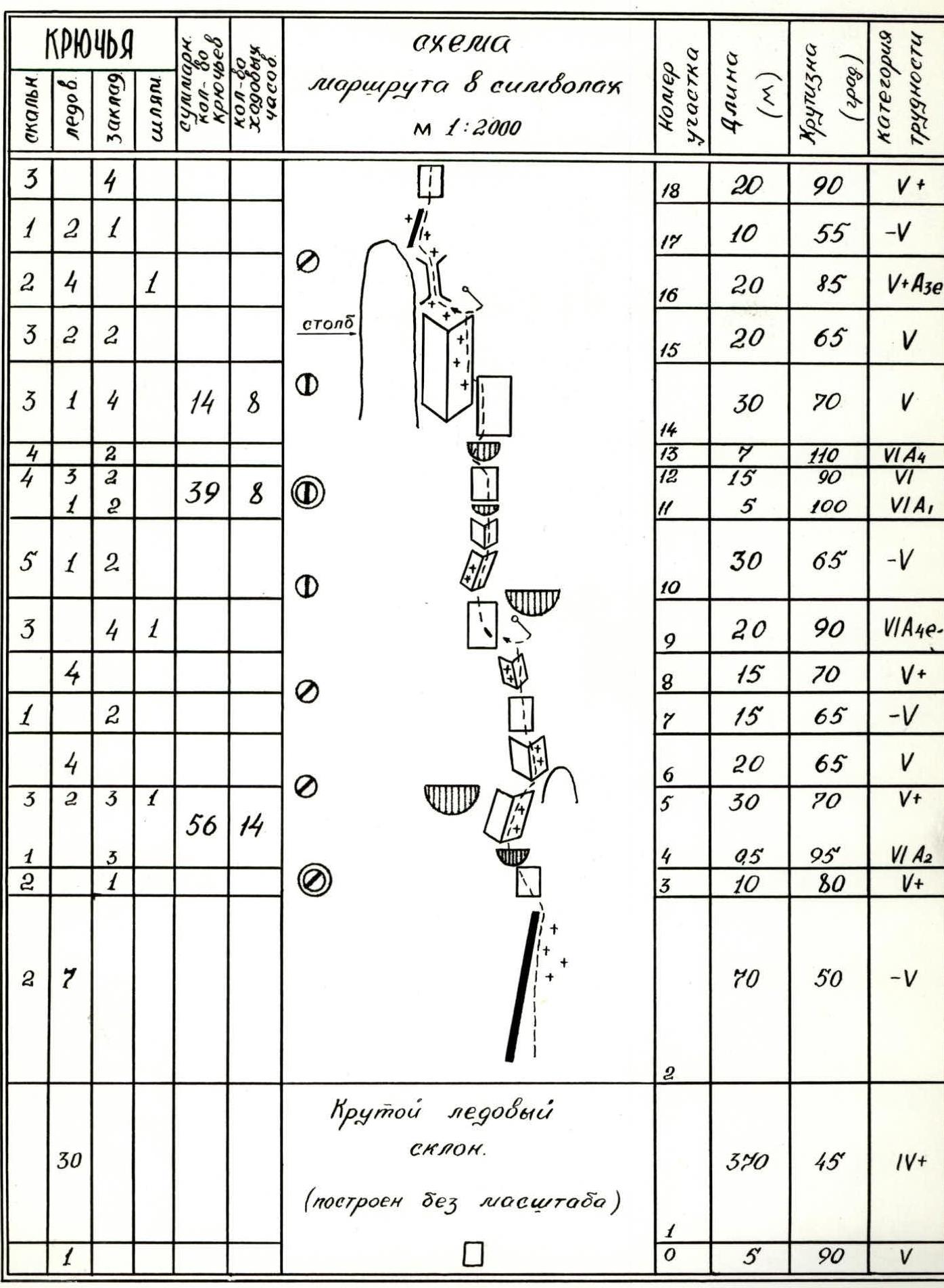
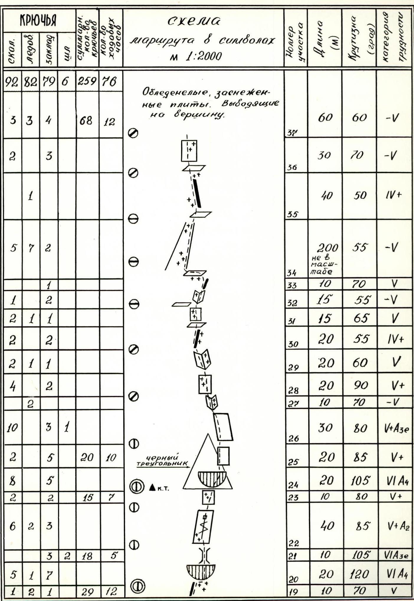
Route diagram in symbols
M 1:2000
| PITONS | Section number | Length (m) | Steepness (degrees) | Difficulty category | |||||
|---|---|---|---|---|---|---|---|---|---|
| rock | ice | chocks | bolt | total number of pitons | number of climbing hours | ||||
| 3 | 4 | 7 | R18 | 20 | 90 | 5 | |||
| 1 | 2 | 1 | 4 | R17 | 10 | 55 | 5 | ||
| 2 | 4 | 1 | 7 | R16 | 20 | 85 | 6 | ||
| 3 | 2 | 2 | 7 | R15 | 20 | 65 | 5 | ||
| 3 | 1 | 4 | 8 | R14 | 30 | 70 | 5 | ||
| 4 | 2 | 6 | R13 | 7 | 110 | 6 | |||
| 4 | 3 | 2 | 9 | R12 | 15 | 90 | 6 | ||
| 1 | 2 | 3 | R11 | 5 | 100 | 6 | |||
| 5 | 1 | 2 | 8 | R10 | 30 | 65 | 5 | ||
| 3 | 4 | 1 | 8 | R9 | 20 | 90 | 6 | ||
| 4 | 4 | R8 | 15 | 70 | 5 | ||||
| 1 | 2 | 3 | R7 | 15 | 65 | 5 | |||
| 4 | 4 | R6 | 20 | 65 | 5 | ||||
| 3 | 2 | 3 | 1 | 9 | R5 | 30 | 70 | 5 | |
| 1 | 3 | 4 | R4 | 5 | 95 | 6 | |||
| 2 | 1 | 3 | R3 | 10 | 80 | 5 | |||
| R2 | 70 | 50 | 5 | ||||||
| Steep ice slope. | R1 | 370 | 45 | 4 | |||||
| (built without scale) | |||||||||
| R0 | 5 | 90 | 5 |
| PITONS | Section number | Length (m) | Steepness (degrees) | Difficulty category | |||||
|---|---|---|---|---|---|---|---|---|---|
| rock | ice | chocks | bolt | total number of pitons | number of climbing hours | ||||
| 92 | 82 | 79 | 6 | 259 | 76 | ||||
| R37 | 60 | 60 | 5 | ||||||
| 3 | 3 | 4 | 10 | 12 | R36 | 30 | 70 | 5 | |
| 2 | 3 | 5 | R35 | 40 | 50 | 4 | |||
| 1 | 1 | R34 | 200 | 55 | 5 | ||||
| 5 | 7 | 2 | 14 | R33 | 10 | 70 | 5 | ||
| 1 | 1 | 2 | R32 | 15 | 55 | 5 | |||
| 1 | 2 | 3 | R31 | 15 | 65 | 5 | |||
| 2 | 1 | 1 | 4 | R30 | 20 | 55 | 4 | ||
| 2 | 2 | 4 | R29 | 20 | 60 | 5 | |||
| 2 | 1 | 1 | 4 | R28 | 20 | 90 | 5 | ||
| 4 | 2 | 6 | R27 | 10 | 70 | 5 | |||
| 2 | 2 | R26 | 30 | 80 | 5 | ||||
| 10 | 3 | 1 | 14 | R25 | 20 | 85 | 5 | ||
| 2 | 5 | 7 | 10 | R24 | 20 | 105 | 6 | ||
| 8 | 5 | 13 | R23 | 10 | 80 | 5 | |||
| 2 | 2 | 4 | 7 | R22 | 40 | 85 | 6 | ||
| 6 | 2 | 3 | 11 | R21 | 10 | 105 | 6 | ||
| 3 | 2 | 18 | 23 | 5 | R20 | 20 | 120 | 6 | |
| 5 | 1 | 7 | 13 | R19 | 10 | 70 | 5 | ||
| 1 | 2 | 1 | 4 | 12 |
Ice-covered, snow-covered slabs. Leading to the summit.
Description of the route by sections
Approach to the start of the route via a non-steep, uncomplicated snow slope. Section R0–R1 — bergschrund 5 m 90°. Passed using ice axe and "Super Mustang" ice axe. Belay from a snow platform in the bergschrund. Ice is hard, dense. Section R1–R2 — ice slope 370 m 45°. Movement along ridges between gullies (small stones are exposed). Belay via ice screws, movement on rappel. Section R2–R3 — bypassing the rock island on an ice "knife" 70 m to the beginning of the wall part of the route 50°. Belay via ice screws, standing on hacked-out platforms. Section R3–R4 — 10 m wall, 80°, traversed left under an overhang, general direction towards a rock shoulder. Cracks filled with ice, many hanging snow caps. Route is snowy. Section R4–R5 — internal corner with a cornice. Protrusion 0.5 m. Passed on I.T.O. Section R5–R6 — internal corner, filled with ice and snow, 30 m 70°. Exit to a shoulder. Caution — snow cornice. Limited possibilities for organizing belay. Belay on a suspended backpack. Section R6–R7 — internal corner 20 m 65°. Covered with a thick layer of ice. Movement in "Futfang" crampons using a "klavik" and a "Shakal" hammer. Belay via ice plugs and rock pitons. Section R7–R8 — transition from the internal corner to the left. Wall 15 m 65°, good large holds. Section R8–R9 — icy steep gully 15 m 70°. Passed using ice climbing techniques. Belay via ice plugs and rock pitons. Movement under a large cornice (large hanging blocks). Section R9–R10 — "Zaltsugom" along the left part of the cornice to a slab. Hairline cracks, closed, using rigid ice axes. Pendulum across the slab to the left into a crack. Total length 20 m 90°. Exit to an indistinctly expressed rock rib. Section R10–R11 — indistinctly expressed internal corner 30 m 65°. Live stones. Limited possibilities for organizing belay. Steepness increases to 85° in the upper part. Section R11–R12 — small overhang 5 m 100°, destroyed rocks. Section R12–R13 — transition to a vertical wall with good cracks in the monolith. Belay via chocks. In the upper part, transition to a vertical ice wall and traverse left 5 m using ice screws as I.T.O. Total length 15 m. Section R13–R14 — rusty cornice 7 m 110° passed "Zaltsugom", using pitons and chocks. Transition to the wall. Section R14–R15 — 30 m 70° along ice gullies to the right along the bastion of the "cucumber". Passage using ice climbing equipment. Section R15–R16 — ice-filled wall 20 m 65°. Movement along narrow ice gullies. Belay via ice and rock pitons. Severely destroyed and frozen rocks. Section R16–R17 — transition "pendulum" along a vertical wall from gully to gully and along the "ice river" 20 m 85° using ice climbing techniques. At the top of the section, transition left to the top of the bastion, representing a steep ice "knife". Limited possibilities for organizing belay at the top. Section R17–R18 — ice "knife" 10 m 55°. Section R18–R19 — exit to a rock wall 20 m 90° with good holds. Section R19–R20 — exit from the wall to an ice-filled slab under a cornice 10 m 70°. Very difficult climbing on "kotyata" (removable tricorns). Under the rock cornice, snowdrifts complicate the transition to the cornice. Section R20–R21 — cornice belt. Traverse right along icy rocks under an overhang. Stepped cornice passed "Zaltsugom" towards a hanging stone. This powerful cornice belt crosses the wall over a large extent and has the most convenient and logical passage in this place. The overhang has a three-stepped character. The first cornice is the most powerful and complex, overcome through a snow cornice on destroyed rocks. Length 20 m 120°. Section R21–R22 — behind the third step, a complex, developed chimney begins with a slope from right to left. Climbed in a stem (icy walls). Belay used bolt pitons. Total length 10 m, steepness 105°. Exit to a small foothold for one foot. Section R22–R23 — up to the base of the "triangle", a 85° slab is visible with a small number of holds, with "live" stones in snow patches. Climbing the slab is problematic, at the beginning of the section, a crack is visible, not very convenient for "Zaltsug". In the upper part, climbing using skywires and ice plugs. Length 40 m. Section R23–R24 — the slab becomes less steep, 80°. The path logically leads to the lower right corner of the "Big Triangle". The slab is smooth, holds are very small. 10 m to the exit under a large rusty cornice on the triangle. Passing the cornice is possible from the left or right side. The left option is more difficult as it involves a smooth, vertical, crack-free slab leading to the cornice. Section R24–R25 — the right, overhanging option for passing the cornice involves a series of vertical, limited cracks. "Zaltsugom" through cracks using the latest chocks like "poker", "anchor", skywire, bent stoppers, and "daisy" hexes. When transitioning from crack to crack, it is necessary to perform pendulums of 2–3 meters. Length 20 m 105°. Section R25–R26 — transition to the right face of the Big Triangle. Section with very destroyed rocks! 20 m 85°. Extremely difficult climbing. Section R26–R27 — transition to a slab on the right face of the triangle. Most conveniently climbed along the right edge of the triangle over the overhang. In the middle of the section, transition to the center of the slab. Climbing on micro-holds. In the upper part, pendulum left 5 m on a bolt piton into an internal, indistinctly expressed corner. Length 30 m 80°. Section R27–R28 — walls of the internal corner are filled with ice, and the middle is clogged with snow. 10 m 70°. Exit to the area of the top of the Big Triangle. Section R28–R29 — smooth, partially icy wall 20 m 90°. Climbing using skywires. Section R29–R30 — through an oblique ice gully into an internal corner with live blocks on the right side and a snow cornice at the top 20 m 60°. Exit from the internal corner to a counterfort. Section R30–R31 — counterfort is a non-steep, stepped rock ridge. Begins with a narrow, sharp rib 20 m 55°. Exit to a ledge. Section R31–R32 — monolithic wall with good holds, visible through a thin layer of transparent ice, chipped off by hammer blows. Length 15 m 65°. Snow ledge. Section R32–R33 — internal corner 15 m 55°. Climbed using removable tricorns "kotyata". Section is snowy. Section R33–R34 — rock rib 10 m 70°, leading to a narrow, steep ledge. Section R34–R35 — along the ledge, traverse left into an ice gully, and along it 200 m 55° exit to a snow "knife". Climbing using ice climbing techniques. Section R35–R36 — snow "knife" 40 m 50°, with cornices in places. Section R36–R37 — rock, destroyed wall 30 m 70°. Section R37–R38 — icy, snowy slabs. Climbing is complicated. Length 60 m 60°. Exit to the summit!