
Orographic Scheme
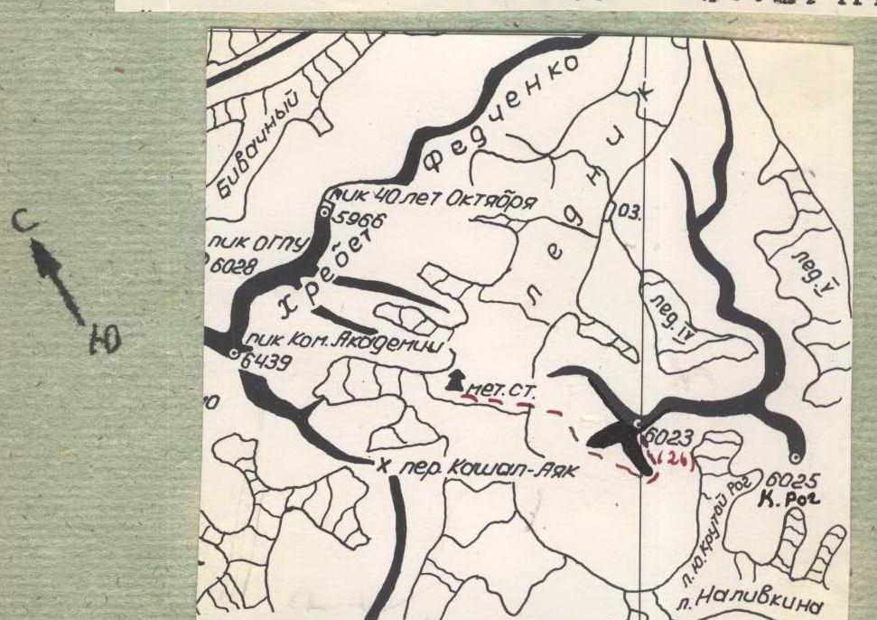
The height of Peak 6026 m is indicated on different maps and diagrams as either 6023 or 6026.
Peak 6026 m (6023 m)
Description of the Ascent to Peak 6026 m (Mehnat) via the Southwest Ridge
Peak 6026 meters is located in the middle reaches of the Fedchenko Glacier, on its right (orographic) bank, almost opposite the GMS "Lednik Fedchenko". Peak 6026 stands out sharply with its size and clearly surpasses the surrounding peaks in height. From the peak, a snow-ice ridge with rock outcrops descends to the Fedchenko Glacier, which divides into:
- northern,
- northwestern,
- southwestern ridges at a height of about 5500 m.
These ridges are rocky and heavily serrated.
The northern and northwestern ridges drop to the Fedchenko Glacier with 200-meter rock walls that are highly prone to rockfall. The southwestern ridge gently descends to the glacier in its lower part.
Between the ridges:
- Between the northern and northwestern ridges — a wide, avalanche-prone snow-ice couloir descending to the glacier with steep, smoothed rock slabs.
- Between the northwestern and southwestern ridges — a rocky, very rockfall-prone and steep couloir.
The rocks on the ridges are brittle, weathered, and rarely intact. Along the northern and southwestern ridges, unnamed glaciers descend to the Fedchenko Glacier with powerful icefalls.
The most safe and logical ascent route to Peak 6026 meters is via the southwestern ridge. The entire route along the southwestern ridge is visible only from the Kaъalaayak Pass. The ascent to Peak 6026 m was made by a group of Uzbek climbers consisting of:
- G. V. Votrin
- V. V. Ovchinnikov
- G. L. Kharlanov
- Yu. M. Uzhenntsev
Between July 22 and 26, 1965. To describe the route more accurately, the group divided it into characteristic sections:
- Day 1, July 22. Approach. Departure from the "Lednik Fedchenko" weather station at 6:00. The journey up the glacier to the start of the southwestern ridge took 1.5 hours. Movement on the glacier was in teams due to many hidden crevasses.
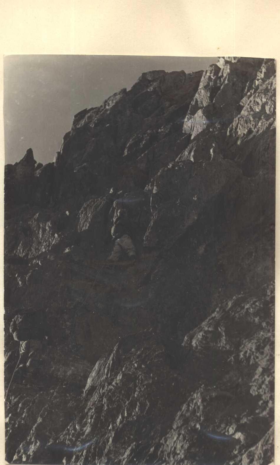
Section #1. Start of the route — 1st Gendarme — rocky ridge.
Note: After the 1st Gendarme and until the summit, the southwestern ridge is flanked on both sides by rock walls and icefalls.
From the Fedchenko Glacier, we move along the southwestern ridge via the lateral moraine of an unnamed glacier (20 minutes), then turn into the first couloir. The couloir is wide with average rocks:
- steepness: 30–35°
- length: 40 m
Insurance in the couloir is through outcrops. After 15 minutes in the couloir, we reach a wide, gentle rocky ridge. The ridge leads to the 1st Gendarme after 150 m. Movement on the ridge is simultaneous.
The 1st Gendarme is bypassed on the left (in the direction of travel) via scree, which leads to a narrow rocky ridge. We called it the "Staircase Ridge".

Section #2 "Staircase Ridge"
The steepness of the ridge in the first 100 m is 35–40°. The rocks are average. Insurance is through outcrops. On this section, only 2 rock pitons were hammered in (almost at the beginning and in the middle), where we had to bypass sharp rock teeth on narrow ledges.
After 100 m, the ridge meets a 15-meter ascent (steepness 65–70°). The ascent is made with piton insurance (3 pitons) directly. The rocks are difficult. After the ascent, the ridge becomes gentler (steepness 30–35°).
Insurance is through outcrops. The rocks are average. And again, after 65–70 m, there is a 20-meter ascent (steepness 60°). It is passed with piton insurance (2 pitons) on difficult rocks, slightly to the left (in the direction of travel). After the ascent, the steepness of the ridge decreases to 30°. After the second ascent, through 40–50 m, there is a 3rd — 12-meter ascent. Steepness 65°. It is traversed to the left on a narrow ledge 5 m and then directly up a crack — exit to a wide, gentle ridge. The rocks on the 3rd ascent are average. Insurance is with pitons. 2 pitons were hammered in. The wide ridge leads to the 2nd Gendarme after 45–50 m. Movement on the ridge is simultaneous.
Section #3 — 2nd Gendarme
The 2nd Gendarme is a concave, wide wall 95–100 m high and 75–80° steep with two small overhanging sections. The rocks are difficult, insurance is with pitons. The first climber goes without a backpack. The 2nd Gendarme is ascended directly, in the middle of the wall.

The second gendarme. Directly from below the middle of the wall:
- Traverse left on a steep, narrow 10-meter ledge (one piton).
- Then traverse right along a 10 m crack (2 pitons).
- Exit to the first overhanging section (1.5 m). It is passed on the left, using a long rock piton as a foothold.
Further:
- Smooth slab (4 m) with good handholds ("pockets"; the toe of the boot does not fit into the pocket).
- Slightly to the right of the slab — a white outcrop.
- From it, 15 m on a diagonal crack (3 pitons) to the second overhanging section (2 meters).
The overhanging section is passed with a rope thrown over a rock tooth and a pendulum to the left — exit to a wide ledge. We gather together on the ledge.
From the ledge:
- Directly up 20 m on difficult rocks (3 pitons) to a rusty spot.
- From the rusty spot, on a not very wide crack 5 m (1 piton) — exit to a small ledge that can fit two people.
- From the second ledge, slightly to the left, 20–25 m on difficult rocks (3 pitons) — exit to the top of the second gendarme.
Section #4 R2–R3
After the Gendarme, 30–40 m on a steep ridge with average rocks. Insurance is through outcrops. Then 70 m of a steep (50°) narrow rocky ridge. Insurance is through outcrops and with pitons (3 pitons). Further, the ridge widens, becomes gentler, and leads to the base of the 3rd Gendarme after 150 m. Movement on this section of the ridge is simultaneous. We camp under the 3rd Gendarme on a good platform. There is also the 1st cairn. The group worked for 13 hours on the first day (from GMS to the 3rd Gendarme).
The upper section of the II gendarme, 2nd day, July 23, 1965. The group started on the route at 9:00.
Section #5 3rd Gendarme:
- The 3rd Gendarme is bypassed on the left (in the direction of travel) on average rocks for 30–40 m.
- Then exit to a snow-ice couloir (steepness 45–50°) and along the right side upwards for 20 m.
- Insurance is with rock pitons (2 pitons).
- Traverse the couloir to the left and again along the left side on rocks upwards for 20 m (1 rock piton hammered in).
- After that, the couloir widens and turns into a wide snow slope (steepness 30–35°).
- The snow slope leads to the top of the 3rd Gendarme.
Section #6. Route between the 3rd and 4th Gendarmes.
- From the 3rd Gendarme, on a 200-meter heavily destroyed ridge — exit to a not very pronounced 4th Gendarme.
- Movement on the ridge is with alternating insurance through outcrops.
Section #7. Route between the 4th and 5th Gendarmes.
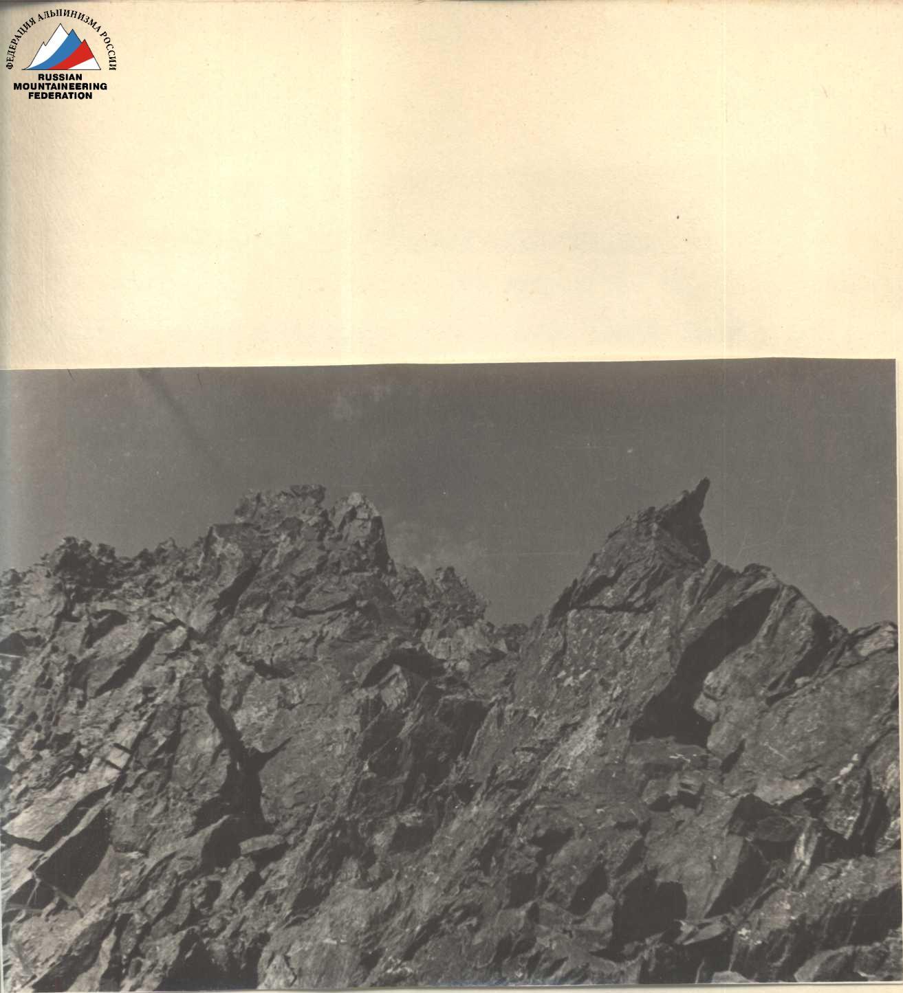
- On the 4th Gendarme, a narrow, steep rocky ridge begins.
- The length of the ridge is about 300 m (steepness 35–45°). Almost at equal intervals, four rocky "fingers" are embedded in the ridge. The height of the fingers is 7–10 m.
The 1st finger is bypassed on the left (in the direction of travel) on average rocks; the rest are passed directly with piton insurance (4 rock pitons hammered in on the fingers). The rocks on the fingers are difficult. The ridge between the fingers is passed with insurance through outcrops. The rocks on the ridge are average.
Section of the route between the 5th and 6th gendarmes (View from above)
Section #8. 5th Gendarme.
The 5th Gendarme is a quadrangle 35–40 m with a not very pronounced internal angle. The ridge with fingers leads to the 5th Gendarme. This Gendarme is ascended directly on the internal angle on difficult, highly smoothed rocks. The length of the angle is 30–35 m. Steepness 60–65°. Insurance is with pitons. 4 rock pitons were hammered in.
The 5th Gendarme is the junction of:
- southwestern,
- western,
- northwestern ridges.
One ridge leads to the summit. On the top of the 5th Gendarme — the 2nd cairn.
Section #9. 5th Gendarme — 6th Gendarme.
From the top of the 5th Gendarme, the 6th Gendarme is clearly visible. Between them — a wide snow-ice 500-meter ridge. From the 5th Gendarme to the middle, the ridge gently descends. The rise of the ridge to the sixth Gendarme alternates with:
- two gentle sections,
- two snow-ice ascents of 80 m, steepness 45–50°.
Snow-ice ascents — with ice screws (total of 2 ice screws hammered in). Under the 6th Gendarme — overnight stay. On the same day, we partially process the 6th Gendarme.
The group worked for 12 hours on the second day. 3rd day, July 24, 1965, the group started on the route at 10:00.
Section #10. 6th Gendarme.
The 6th Gendarme is a huge triangle on a wide ridge. Bypassing the 6th Gendarme on steep ice slopes (up to 55°) is possible but requires much more time to pass. The first 20 m of the Gendarme are passed on a pronounced groove (steepness 75–80°) with accumulated ice. Insurance is with pitons. 4 rock pitons were hammered in. To the left and right of the groove are steep

Section of the route between the 7th and 8th gendarmes — heavily destroyed rocks, covered in ice.
After the groove — traverse left on a crumbly rock ledge 4–5 m and exit to a rock edge:
- Length of the edge — 30 m
- Steepness — 50–55°
- Rocky section — difficult, handholds are smoothed
- Insurance — with pitons, 4 rock pitons hammered in
The edge leads to an ice wall:
- Length * 20 m
- Steepness — 40–45°
- Passage — with chopping steps and hammering in ice screws (2 ice screws hammered in).
Section #11
Route between the 6th and 7th Gendarmes. After the 6th Gendarme — a wide ice ridge 200 m long. The ridge leads to the 7th Gendarme. Characteristics of the ridge:
- Gentle
- Places are covered with snow
Movement in teams is simultaneous.
Section #12
Route between the 7th and 8th pre-summit Gendarmes. The 7th Gendarme is bypassed on the left (in the direction of travel) on a snow-ice slope (steepness 35°) with chopping steps. After the Gendarme — a 120-meter snow drop with rock outcrops (insurance through ice axe). After the drop — an even ridge with a cornice (50 m) and a 60-meter snow-ice ascent (steepness up to 35°). It is passed with chopping steps. Then a small gentle descent and a 100-meter, initially snow, and then ice ascent (steepness of the ice ascent 40°). In the upper part, we hammer in an ice screw and chop steps. After that — a 40-meter snow-ice descent (not steep) and again a snow-ice 30-meter ascent. The first 40 m are passed easily.

8th gendarme and summit. Then the steepness increases to 40° and ice appears. On the ice — with chopping steps and hammering in 1 ice screw. 10 m to the rocky ridge (length of the ridge 30 m, steepness 45–50°) and exit on the ridge to a 200-meter snow plateau. The rocky ridge is difficult, passed with piton insurance (3 pitons hammered in). On the snow plateau — exit to the 8th pre-summit gendarme and overnight stay. On the section of the route between the 7th and 8th gendarmes, there are many hidden crevasses in the most unexpected places. The group worked for 9 hours on the 3rd day.
4th day, July 25, 1965.
Section #13 — 3rd overnight stay — summit.
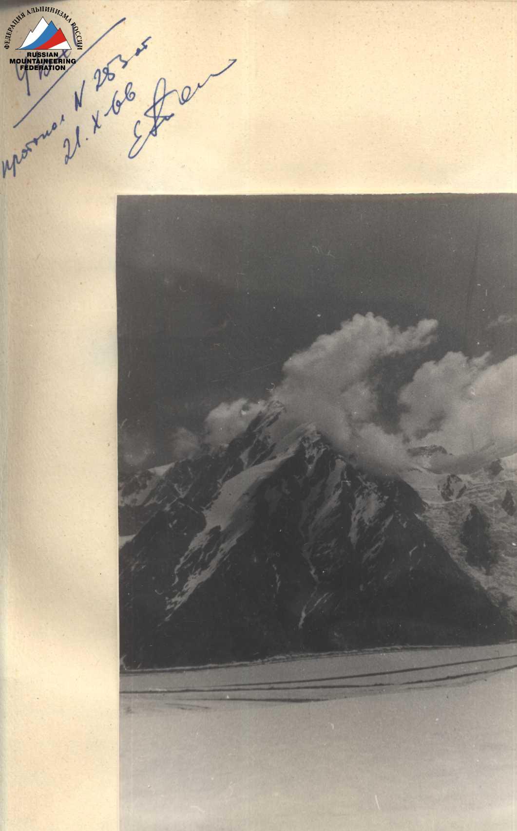
The 8th pre-summit gendarme is heavily destroyed. It is passed directly simultaneously. After the Gendarme — a gentle snow ridge with cornices (250–300 m), turning into a gentle rocky ridge (300 m). The ridges are wide but drop on both sides with icefalls. The rocky ridge leads to the summit. The summit is a rocky tower 70 m high with an overhanging ice cornice on the left. The ascent to the summit is on a pronounced ice-rock couloir — 40 m (steepness 45° along the left side, 3 rock pitons hammered in), then on average rocks to the summit. The cairn is left to the right of the ice overhang on a well-visible rocky outcrop. The ascent took 4 hours. By the right of the first ascent, the peak was named Peak "Mehnat".
On the summit
(In the background — Peak Kom. Akademii) It was clear, although the wind was strong. A wonderful panorama of mountain ridges opened before us. The peaks were clearly visible:
- Kommunizm
- Pravdy
- Garmo
- Kom. Akademii Revolyutsii
- and others.
On the same day, we descended along the ascent route to the second overnight stay. The descent took 4 hours.
5th day — July 26, 1965. Descent. Descent along the ascent route to the 5th Gendarme, from it on a snow-ice couloir (along the right side in the direction of travel) between the northwestern and western ridges to rocky slabs. On the slabs to the left (in the direction of travel) with 3 sports descents of 40 m — exit to the Fedchenko Glacier. The descent took 6 hours. Crossed the Fedchenko Glacier (2 hours) and at 17:00 on the 5th day of the ascent, we were at GMS "Lednik Fedchenko".
Note:
The group took 36 hours to ascend the southwestern ridge to the summit (not counting the approach along the glacier). The descent to the Fedchenko Glacier took 10 hours. On the ascent, the following pitons were hammered in:
- rock — 48
- ice — 6
On the descent:
- rock — 6
- ice — 2
The weather during the ascent was good.
Recommended equipment for a group of 4 people:
- High-altitude tent.
- Main rope 2×40 m.
- Ice screws — 2 pcs.
- Rock pitons — 12 pcs.
- Carabiners — 10 pcs.
- Personal equipment — standard.
- Spare rope for descent — 2 m.
The group believes that the described route is not below category 5A.
Group leader: G. Votrin — 1st sports category.
Participants:
- V. Ovchinnikov — 1st sports category
- G. Kharlanov — 1st sports category
- Yu. Uzhintsev — 1st sports category