Ascent Log
I. Class: technical 2. Climbing area: Pamir-Alai, Alai Range 3. Ascent route: Leninets Peak via North face 4. Difficulty category: 5B 5. Route characteristics: elevation gain: 1100 m; length of 5-6 difficulty section 925 m; average steepness 60° 6. Pitons used: for belaying, for creating ITO: rock 22, ice 42, chocks 26 7. Climbing hours: 13 8. Number of bivouacs and their characteristics: none 9. Surname, name, patronymic of the leader, participants, and their qualification: Bayakin Sergey Gennadievich, CMS Kolotiy Valery Ivanovich, CMS 10. Team coach: Yakovlev Vitaly Dmitrievich, Master of Sports of the USSR
II. Date of departure and return: Departure: July 31, 1978 Return: July 31, 1978
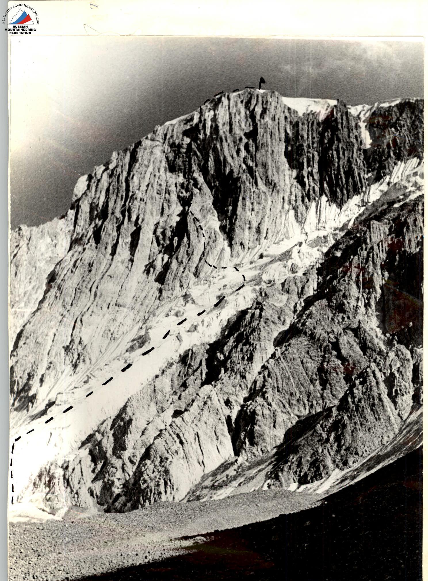

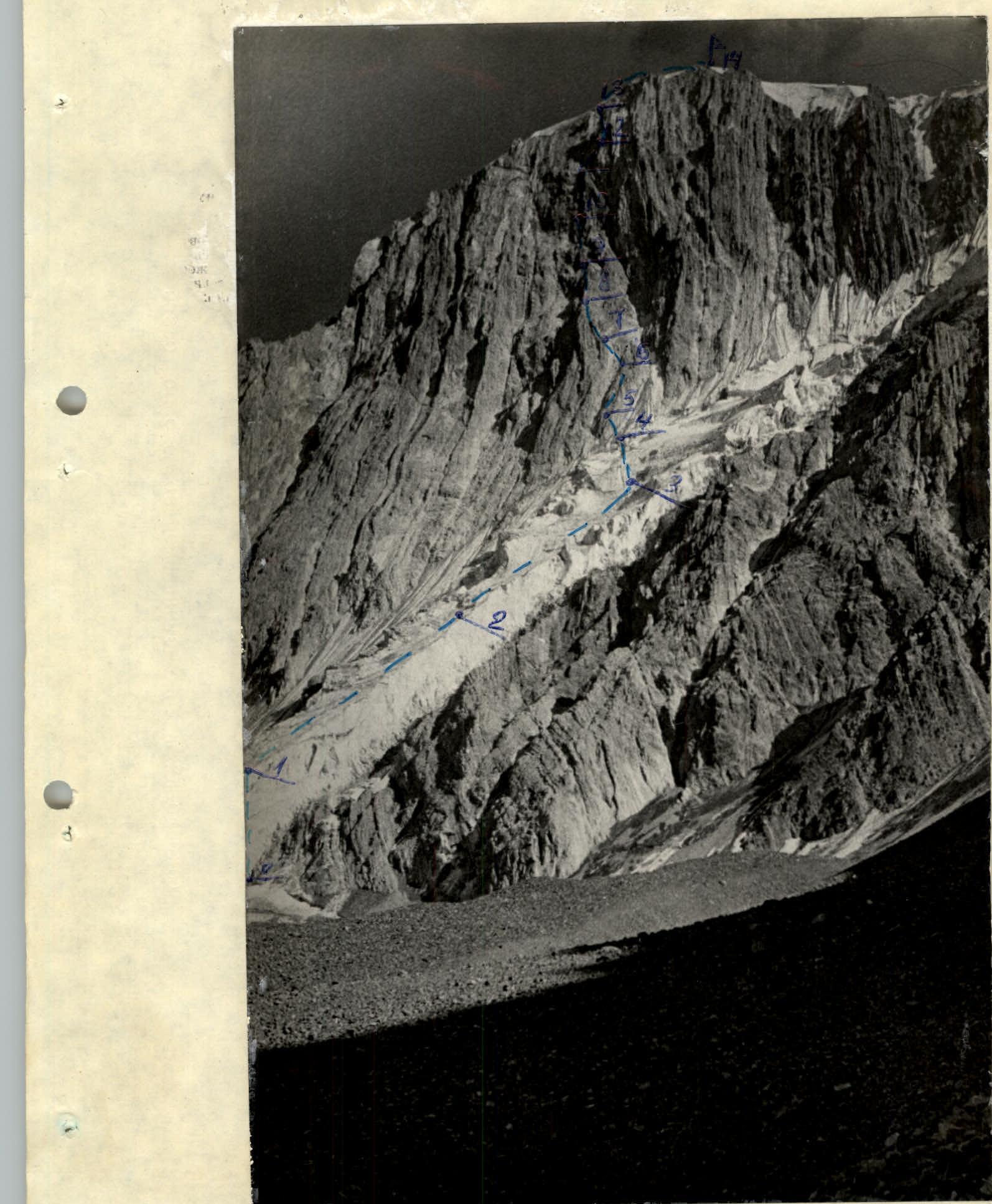
Table of main characteristics of the ascent route to Leninets Peak via North face
| Date | Designation | Average steepness | Length | Terrain character | Difficulty category | Condition | Weather conditions | Rock | Ice | Chocks | Bolts |
|---|---|---|---|---|---|---|---|---|---|---|---|
| 31.07.1978, 2:00 | R0–R1 | 65° | 80 | ice | 5 | ice | clear | 8 | - | - | - |
| R1–R2 | 60° | 150 | ice | 5 | ice | - | 15 | - | - | - | |
| R2–R3 | 65° | 140 | ice | 5 | ice | - | 14 | - | - | - | |
| R3–R4 | 65° | 60 | ice | 5 | ice | - | 5 | - | - | - | |
| R4–R5 | 55° | 60 | wall | 5 | broken | - | 3 | - | 2 | - | |
| R5–R6 | 60° | 80 | wall | 5 | broken | - | 3 | - | 3 | - | |
| R6–R7 | 45° | 60 | gully | 4 | broken | - | 2 | - | 2 | - | |
| R7–R8 | 75° | 60 | wall | 5 | broken | - | 5 | - | 3 | - | |
| R8–R9 | 50° | 65 | wall | 5 | broken | - | 2 | - | 4 | - | |
| R9–R10 | 55° | 70 | wall | 5 | broken | - | 3 | - | 4 | - | |
| R10–R11 | 65° | 80 | inner corner | 5 | broken | - | 2 | - | 6 | - | |
| R11–R12 | 45° | 90 | couloir | 4 | broken | - | belay via outcrops | ||||
| R12–R13 | 60° | 80 | wall | 5 | broken | - | 2 | - | 2 | - | |
| R13–R14 | 40° | 300 | ridge | 3 | ice | - | simultaneous movement |
Brief explanation of the table. R0–R1. Up the ice directly - movement in crampons on front points. R1–R2. Movement along the right edge of the glacier. R2–R3. Section traversed in crampons. Bergschrund at the top of the section. R3–R4. Glacier is crossed towards the bergschrund, which is bypassed on the right. R4–R5. Ice section ends. Exit to the rock wall. R5–R6. Wall, steep broken rocks. R6–R7. Crossing the gully. Exit to the yellow wall. R7–R8. Broken wall with a small cornice. R8–R9. Up the broken wall to the left. Exit to a small ledge. R9–R10. Steep vertical wall composed of sandstone. R10–R11. Vertical inner corner. Movement straight up. R11–R12. Crossing the couloir with exit to the opposite wall. R12–R13. Wall becomes less steep at the top, exit to the pre-summit ridge. R13–R14. Ice ridge. Movement in crampons.


