DESCRIPTION OF THE FIRST ASCENT OF THE ROUTE TO THE SUMMIT OF KALKUSH FROM THE PASS "CHETYREKH" (FOUR) 2B cat. diff.
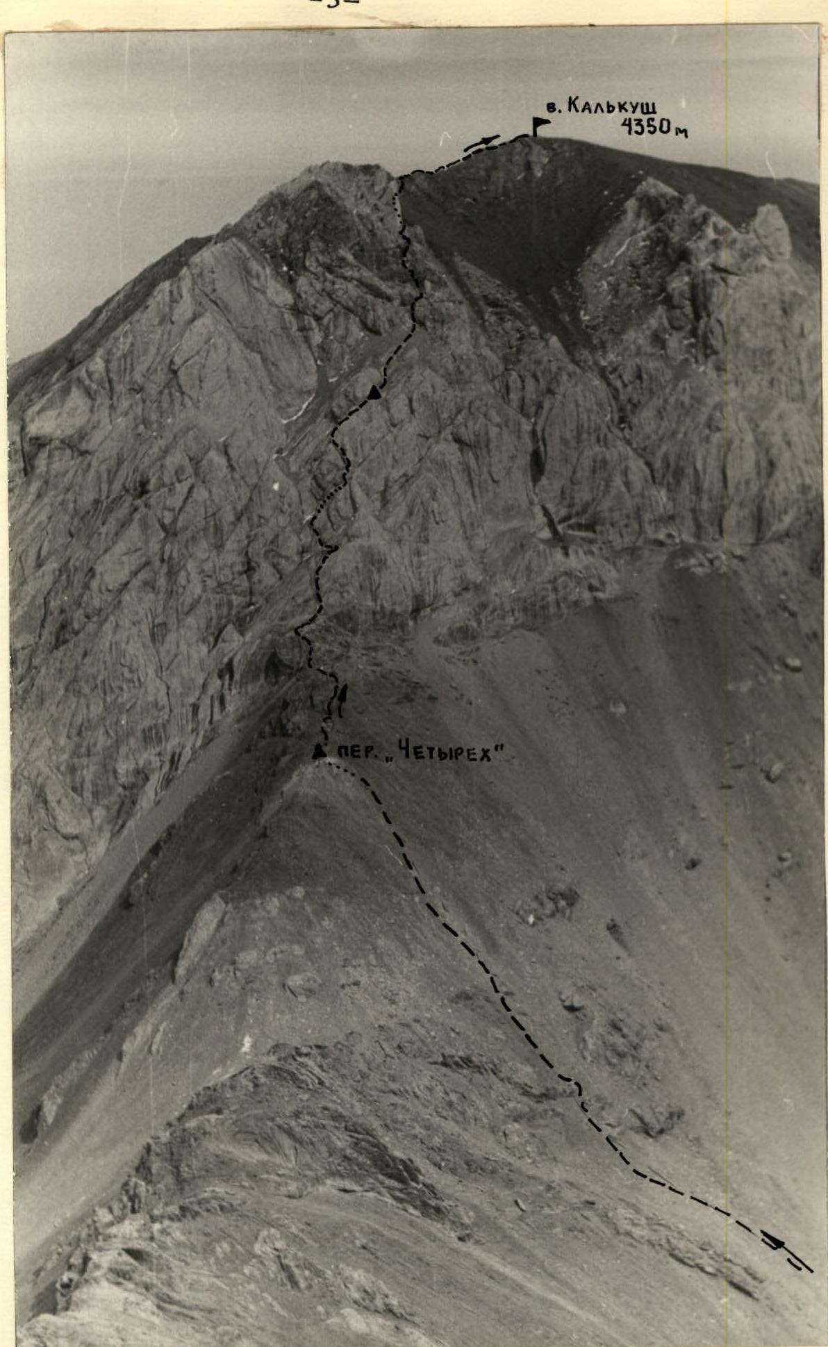
The summit of Kalkush (photo from the summit of Skalnaya)
Approach routes:
- From the Dugoba alpine camp, ascend up the left side (orographically) of the Dugoba river to the second confluence (confluence of the Ak-Tash and Dugoba rivers).
- Here are the overnight stays.
- The journey from the alpine camp to the overnight stays takes 2.5–3 hours.
From the overnight stays, the path lies to the pass "4-kh". First, upwards in the direction of the Kalkush summit, then under the eastern slopes of the Kalkush summit to the last (along the path) buttress of the summit. The path lies along a good trail. Then, bypassing the buttress, we begin the ascent to the pass "4-kh". The path lies across the scree.
The ascent to the pass from the overnight stays takes 2 hours 30 minutes.
There is a cairn on the pass.
The route begins from the cairn on the pass. Along the rope, a wide gentle ridge ascends to a 10-meter wall, which is overcome through a narrow chimney.
Further:
- ascent along the ledges (8–10 m) to a rock resembling "ram's foreheads";
- ascent to it from the left along the path;
- 1.5 ropes up the scree under the wall.
The wall is passed through a cleft. The cleft initially goes to the left, then sharply turns to the right and turns into a wide, gentle, short corridor. The length of the section is 16–20 m.
Further:
- 1.5–2 ropes along easy rocks (ledges covered with small scree) to the wall;
- a 12-meter wall with a steepness of 70–75°, overcome through a vertical cleft.
In the upper part, the wall becomes gentler (up to 50°) and leads to a small ridge. The duration of the ridge is one rope. Its steepness is initially 60°, then decreases to 30°.
Exit to a site covered with scree, under a 30-meter rusty wall. On the site is a control cairn. The wall is bypassed to the right along a narrow 2-meter ledge.
Further:
- ascent along steep rocks covered with scree, 1.5 ropes to a large round boulder;
- the boulder is bypassed to the left through a 3-meter chimney (steepness 85°), with a plug in the upper part;
- ascent along the ledges to the right upwards with simultaneous belay under a finger-like "gendarme".
The "gendarme" is bypassed to the right, then - ascent along the steep scree (sticking to the rocks) to the pre-summit ridge (2.5–3 ropes). The ridge is gentle, with a length of 2.5–3 ropes. Towards the Kalkush gorge, the ridge breaks off with steep walls. In the middle, the ridge narrows, and a section of about 10 m is passed with variable belay. The remaining path is traversed simultaneously.
Throughout the entire route, there are reliable ledges for organizing belay and self-belay.
The ascent from the pass to the summit takes 3 hours.
The descent from the summit is known - along the route 2A cat. diff.
For the ascent report, in addition to the note from the summit, the group presents notes from:
- the pass "4-kh",
- the control cairn.
The first ascent of the route was made by a group of climbers from the Dugoba alpine camp in August 1969, with the following composition:
- Denisova G. - leader
- Popov G. - participant
- Smolina S. - participant
- Kurmakaeva V. - participant
- Alekseeva T. - participant
- Emelyanenko Yu. - trainer-observer.
The group evaluates the route as 2B cat. diff. In the 1969 season, two more groups of climbers passed the described route and confirmed its correspondence to 2B cat. diff.
The description was compiled by Yu. Emelyanenko.

