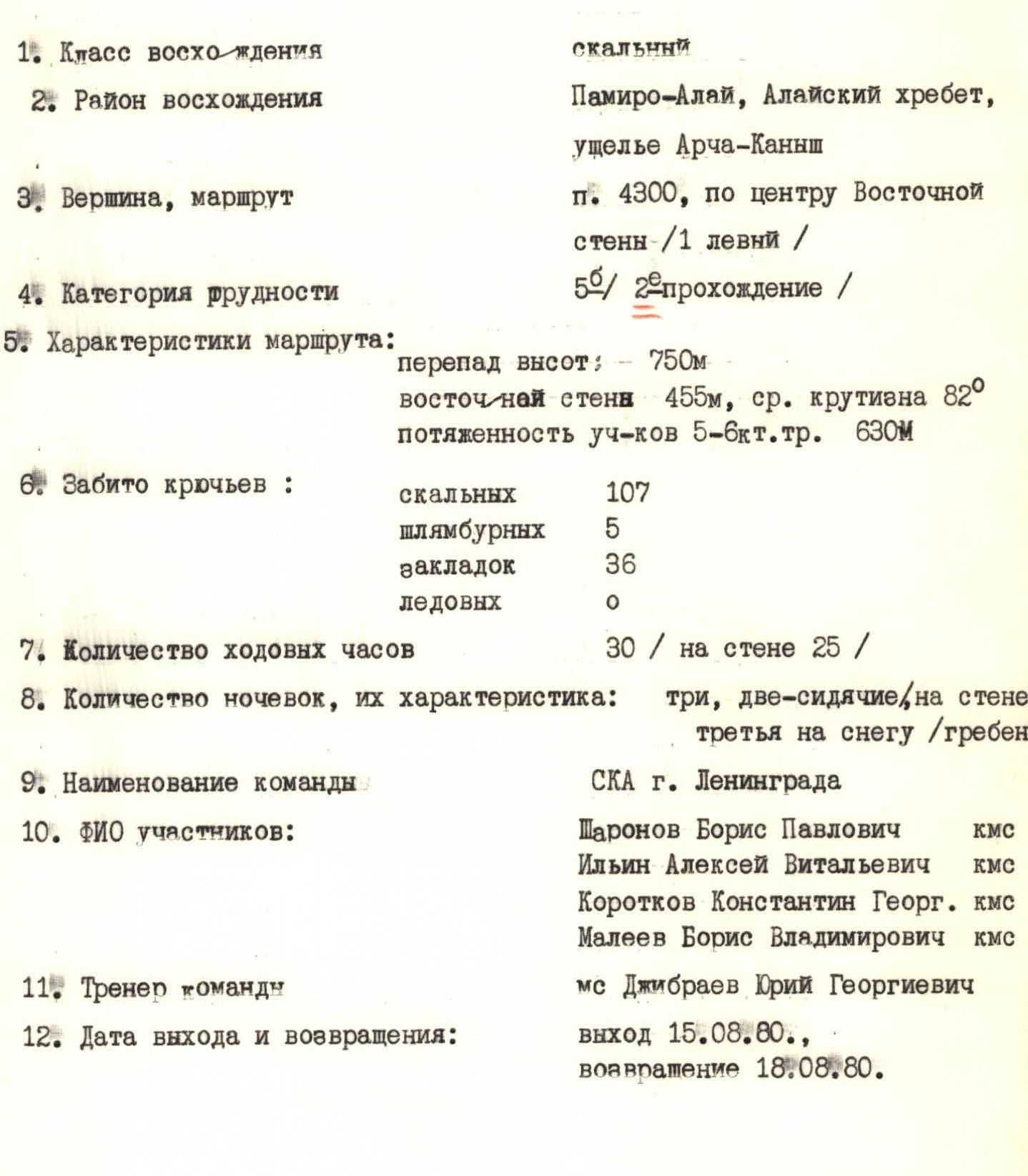

ASCENT LOG 23
- Type of ascent: rock climbing
- Area of ascent: Pamir-Alay, Alay ridge, Archa-Kanysh gorge
- Peak, route: p. 4300, via the center of the Eastern wall (1st left)
- Difficulty category: 5B / 2nd ascent /
- Route characteristics:
- Height difference: 750 m
- Eastern wall 455 m, avg. slope 82°
- Length of sections with 5–6 difficulty category: 630 m
- Number of pitons used:
- Rock pitons: 107
- Bolt pitons: 5
- Chocks: 36
- Ice screws: 0
- Number of climbing hours: 30 / on the wall: 25 /
- Number of bivouacs, their characteristics: three: two sitting on the wall, third on snow (ridge)
- Team name: SCA of Leningrad
- Participants' full names:
- Sharonov Boris Pavlovich CMS
- Ilyin Alexey Vitalyevich CMS
- Korotkov Konstantin Georg. CMS
- Maleev Boris Vladimirovich CMS
- Team coach: MS Dzhibrayev Yuri Georgievich
- Departure and return dates:
- Departure: August 15, 1980
- Return: August 18, 1980
Brief description of individual sections
Approach to the start of the route, marked by a pronounced counterfort in the left part of the E. wall, via an ice-fall prone couloir.
R1. Ascend to the counterfort from the left, "screwing" (stones fall from the right) onto the wall and then to a small ledge.
R2. From the ledge straight up the smooth wall ~5 m and into an internal angle with a cornice. The internal angle leads to a small shelf — the base of the counterfort.
R3. From the shelf, ~10 m along slightly destroyed rocks under the wall, then into an internal angle that leads to a wide ~3 m long shelf.
R4. Along the shelf to the left into the base of the overhanging internal angle with a small cornice at the top. Very difficult climbing, lack of cracks and holds.
R5. From under the cornice straight up again and along the rock wall through a small overhang at the top, exit onto a comfortable ledge for belay.
R6. From the ledge straight up the internal angle formed by a fragment broken off the main wall.
R7. In the upper part of the internal angle, left through a bend (very difficult!) and along the wall to a ledge under the base of a ~50 m high wall. In the right part of the wall — an overhanging fragment, rust-colored, forming an internal angle with the wall. Along the wall under the fragment and through the angle to a cornice, then through the cornice and right along the wall to the top of the fragment. Narrow ledge — 1.0 m. Overnight stay.
R8. From the fragment begins the key section of the route. From the bivouac slightly left to a small fragment at the wall along the angle — fissure.
R9. From the fragment up the wall through a small cornice. Very difficult climbing, no piton belay. Along the wall ~30 m and exit to a small ledge (only for two people). From the ledge left along the "mirror" of the wall ~10 m and then along the internal angle to the next cornice. Very difficult. Through the overhanging cornice and again into the internal angle, along which under another cornice above the wall. From under the cornice right along the fissure — internal angle, exit to a ledge. Sitting bivouac for 4 people. Control section. The section is climbed using ladders, 4 bolt pitons. Difficulties with organizing belay: blind cracks, lack of holds.
R10. From the bivouac along a large overhanging internal angle ~60 m, transitioning from steep sections to a vertical wall, ending in a cornice. Under the cornice right up ~5 m and then along the left edge of the cornice exit onto the wall, along which left up to a ledge. The upper part of the section is climbed using ladders with the use of chocks.
R11. Slightly right and up a chimney with a plug, then along a smooth wall under a cornice and left onto a bridge under a destroyed vertical wall.
R12. Along the destroyed vertical wall straight up, rockfall prone, piton belay is difficult.
R13. The wall becomes less steep and ~20 m along relatively gentle rocks, exit onto the "roof".
R14. On the "roof" of the wall along rock ridges exit onto the ridge of the E. wall. From the ridge, a couloir is visible below, separating the E. wall from the main massif of p. 4300.
R15. Descent into the couloir.
R16. From the snow base of the couloir along the left rock wall exit onto a bridge.
R17–R21. From the bridge along rock walls straight up — to the summit of p. 4300 and then along the ridge to peak XXII Olympiada. Descent from the summit in the direction of peak Leningradets.


