August 7, 2034
Description of the Traverse Route of the North and South Peaks of "4530" (K. Aleksandrova)
From the base camp on the green meadow, the twin-peaked summit 4530 m is visible in the northwest direction. It is located in the same ridge as the peaks "4302 m" and "4500 m" and is situated between these two mentioned peaks.
After crossing the Sary-Kainou river 200 m above the camp, one needs to descend about 2 km downstream to the point where ascent to the saddle between the peak "4530 m" and "4500 m" is possible.
The ascent to the saddle is done:
- initially up the grassy slope for 200–250 m to reach a small cirque (a hollow between the spurs) where large rock boulders (fallen from the neighboring slopes) have accumulated and formed a large talus;
- beyond the cirque, a medium talus begins, which turns into a fine talus near the saddle.
The journey from the camp to the saddle takes an average of 3 hours of walking.
The path from the saddle goes along the snowy slope to a rocky outcrop ending with a small "Gendarme No. 1," which is traversed along the medium rocks for 30 m.
Gendarme No. 2 on the ridge is bypassed on the right side along the edge, close to the rocks (see photo No. 4). Beyond the second "Gendarme," the ridge sharply changes its steepness and reaches 45°, extending for 90–100 m. Movement is necessary with insurance through an ice axe.
Then, on the path, a second rocky outcrop is encountered, which is traversed on its right side along heavily destroyed medium rocks for 75–80 m. Beyond the rocky outcrop, the ridge turns into a small snow-ice wall, with a steepness of 55° and a length of 10–12 m. Beyond this wall (in case of a fall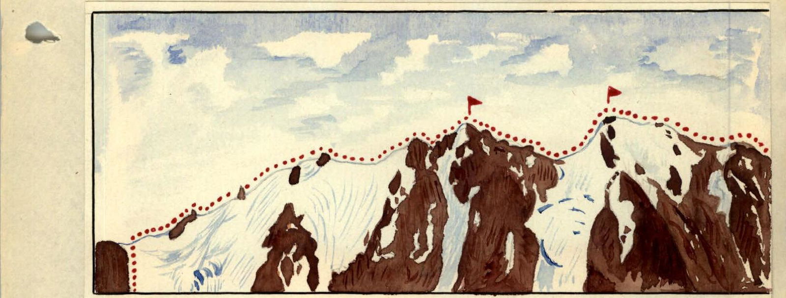 )
)
The route to the north and south peaks of K. Aleksandrova 4530 m. From the west.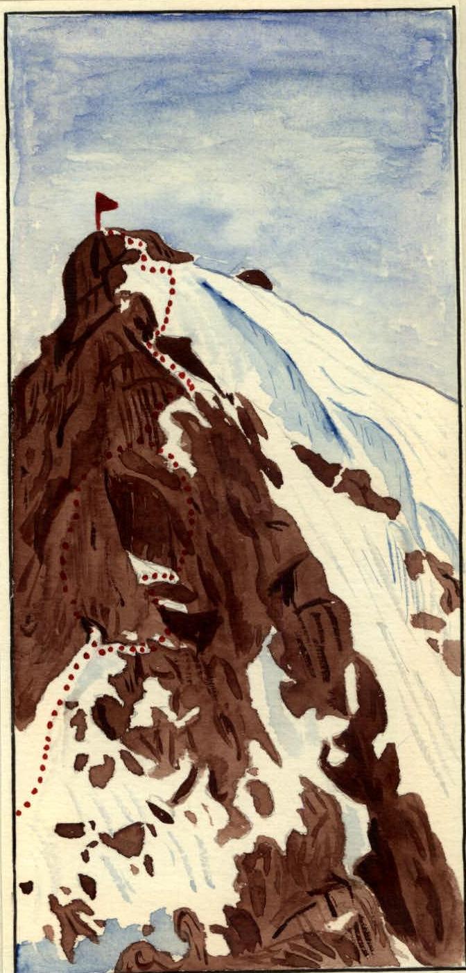
K. Aleksandrova Peak "4530 m". Section of the ridge upon reaching the North Peak. The great depth of the fall adds to the danger of falling down the right slope, which turns from a gentle snowy slope into a snow-ice wall at 60–65°. "Gendarme No. 3" on the ridge (see photo No. 4) is bypassed on the right side in the direction of travel. Both the bypass of "Gendarme No. 3" and the subsequent 300 m of the ridge with a "camel's hump" before the sub-peak are overcome with thorough insurance through an ice axe. At other times during the summer, when the slopes are free of snow, this section will require the use of ice climbing techniques and will present sufficient difficulty in overcoming it. The ascent to the sub-peak of the North Peak is done along medium rocks, turning into a 25-meter wall (one piton). Descent from the sub-peak by "sitting on the rope" down a 20-meter wall leads to "Gendarme No. 4," which is traversed on the right side in the direction of travel. Further, to descend to the saddle, it is necessary to overcome two sheer chimneys - one 15 m and another one rope length long. The entire group passes these chimneys by "Dülfer" method and, having passed the last chimney, finds itself much lower than the saddle, as descent along the ridge is impossible due to the severe destruction of the rocks and the exceptional danger of falling. Having overcome a steep snowy slope 90 m long, the group approaches a complex section of the ascent to the North Peak. The ascent directly up the sheer inner corner is exceptionally complex and lacks suitable platforms for insurance. The second option: traverse to the right, ascent up an 8-meter wall to a snow patch, another traverse to the right along the snow patch, exit through a crevice to the upper part of a 40-meter wall, which is overcome 15 m up, then 8–10 m to the left with an exit to the ridge. (See photo No. 7), the group proceeds with the second option, having driven 5 rock pitons on the section. Further, 10 m of the ridge are overcome by "edgewise" method (see photos 6, 7) and a 3-meter wall with an exit to a snow patch. The ascent to the North Peak, which is 4480 m high, is done along the snow patch.
The descent from the North Peak begins with two small 6-meter walls, followed by a heavily destroyed ridge for 100 m. After this, the ridge drops sharply and leads to the fifth "Gendarme." On this section of the ridge, about 90 m long, two 8-meter walls need to be overcome. The fifth "Gendarme" is a huge rock "blade," slightly inclined to the east. It is bypassed on the left side under an overhanging rock along a 30-meter small ledge-crevice under a 200-meter abyss. When bypassing the Gendarme, 3 pitons are driven for insurance. Before the sixth Gendarme on the left - a 10-meter wall, one piton is driven. Gendarme No. 6 is passable "head-on": ascent up a 6-meter and descent down a 25-meter wall to the right slope of the ridge. A horizontal traverse of 30 m brings the group back to the ridge. Having walked along it for about 25–30 m, we approach a wall, the descent from which is done down two 20-meter chimneys by "sitting on the rope." Finally, the saddle between the North and South Peaks is reached. From the col to the South Peak leads initially a snowy slope for 200 m, then the steepness of the slope increases to 50–55° and turns from snowy to ice-rocky. This section of the traverse is exceptionally complex and is about 200 m long. It is overcome with piton insurance along rocky outcrops, with the gaps between them traversed with step-cutting. On this section, another 7 rock pitons are driven. And here the peak is under us, with an elevation of 4530 m above sea level. Dusk is approaching, and we still have a long descent to the camp, which is below us on the left. The descent from the South Peak is done along a heavily destroyed ridge with easy, sometimes medium rocks, but with the approaching darkness, their difficulty doubles. Having descended from the ridge, we move along fine talus, then along medium talus, and after 600–700 m, we reach grass. In complete darkness, by the light of pocket lamps, we return to the camp. The traverse of the North and South Peaks of 4530 m took the group 15 hours of intense technical work. For the first time, the traverse of the North and South Peaks of 4530 m was accomplished by a group of climbers from the Kazakh Republican Club of Climbers, consisting of: Mansurov Babir - leader, participants Krasilnikov Boris, Gonyalin Vladimir, Borzut Anatoly, and Boris Kuklichev. The difficulty of the route is assessed as 4A category of difficulty.
The description was compiled by B. Mansurov. During the traverse, the group used the following climbing equipment:
- Main ropes - 2 pcs.
- Auxiliary ropes - 1 pc.
- Rock pitons - 8 pcs.
- Carabiners - 8 pcs.
- Rock hammers - 2 pcs.
- Ice axes - 5 pcs.
- Chest harnesses - 5 pcs. (two of them in the form of 4 rings were left during the "Dülfer" descent).
The peak was conquered on August 24, 1957. With the original: wine -