Location of the summit. The summit is located in the northeastern part of the Baubashata ridge, which is situated at the northwestern end of the Fergana ridge, and has an elevation of 3700 m (Fig. 1). The nearest settlement is the Toktogul hydroelectric power plant builders' settlement. Kara-Kul is located on the Frunze-Osh highway, 220 km from Osh (bus service).
First ascent was made on October 6-8, 1972, by a group of climbers from Kara-Kul, consisting of:
- Morozov I.V. (leader),
- Romantsova S.Ya.,
- Telbuh P.S.,
- Voloshin A.A.
Approach. From Kara-Kul settlement, drive along the road to the Kaindy river gorge for 45 minutes (17 km). Then:
- Follow the trail along the river.
- Cross to the left bank (here and further, orographically) and ascend to the Birch grove.
- At the exit from the grove, the trail crosses to the right bank of the river.
Up to this point, it's a 1-hour walk from the start of the trail. Then:
- Walk for 1 hour along the right (orographically) bank of the Kaindy river, to the first left-bank tributary, above which cross to the left bank of the river.
- Above the tributary, cross to the left bank of the river.
On the left bank, after crossing, there's a good spot for an overnight stay.
Further movement is up the trail along the first left-bank tributary to the narrow rocky gates called "Wolf's Gates". At the gates, the trail crosses to the left bank of the river, and soon after the gates (10 minutes' walk) - again to the right bank. On the right bank, there's a large clearing (1 hour's walk).
Then, move for 1 hour to the confluence of the rivers. The left (orographically) tributary goes towards the ridge, leading to the main ridge near the "Kashak-Su" summit.
Further movement is along the trail along the tributary - sometimes on one bank, sometimes on the other - initially through the forest (about 1.5 hours' walk), and then 1 hour 30 minutes along the talus slope of the left slope of the valley, to a small lake.
On the right bank, near the lake, there's a good spot for a bivouac.
Ascent route. Further movement is up the left bank, up the valley, located between the spurs, going towards the main ridge. Walk along the middle of the wide part of the valley. After the rocky gates, walk along the talus slope of the left (orographically) slope of the valley under the massive rocky island (Fig. 2).
Climb the slopes of the island to the terminal moraine of the glacier, and then move towards the saddle, located in the left (in the direction of movement) spur. On the horizontal section of the moraine, under the slopes of the summit, there's a spot for a bivouac. From the lake to the bivouac, it's a 3-hour walk.
Then, move along the talus slope between the summit and pre-summit counterforts. In the upper part of the talus slope, there's an exit to the rocks, and along them - to the saddle on the ridge. Move along the rocks with simultaneous or alternating belay. From the saddle, move along the ridge to the right, towards the summit. Movement along the rocks of the ridge is of moderate difficulty, with alternating belay. From the overnight stay to the summit, it's a 2-hour walk.
Descent is via the ascent route. From the summit to the overnight stay, it's a 1-hour descent.
Time expenditure
Approach from the end of the road to the lake - 6.5 hours. Ascent to the summit - 5 hours. Descent with movement to the road - 7 hours.
18.5 hours
If there are two days available for the ascent, it's recommended to depart from Kara-Kul in the evening, with overnight stays in the Birch grove (first) and near the lake (second).
The group considers it possible to classify the route as category 1B.
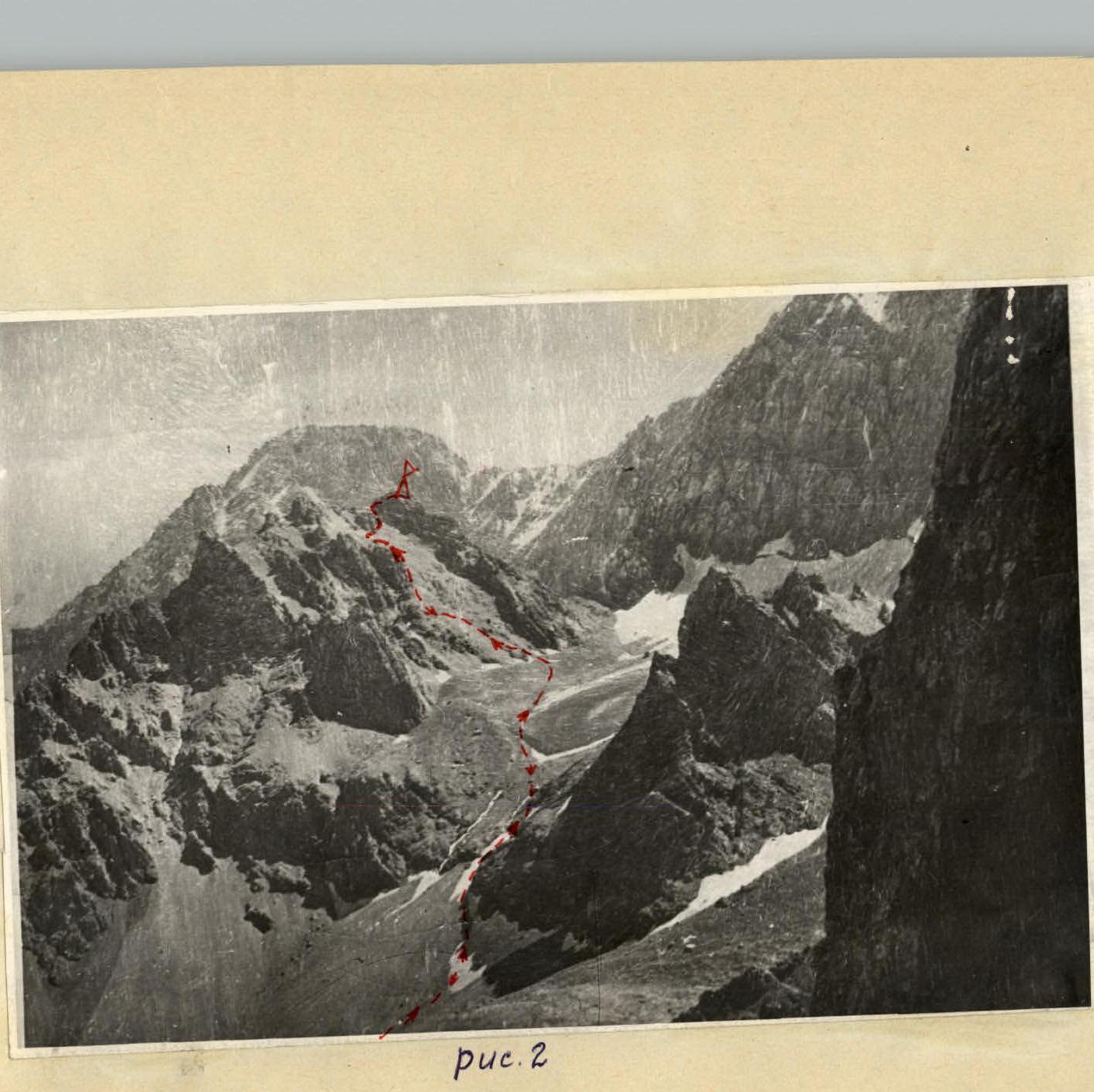 Fig. 2
Schematic map of the upper reaches of the Kaindy river
Scale - 1:100 000
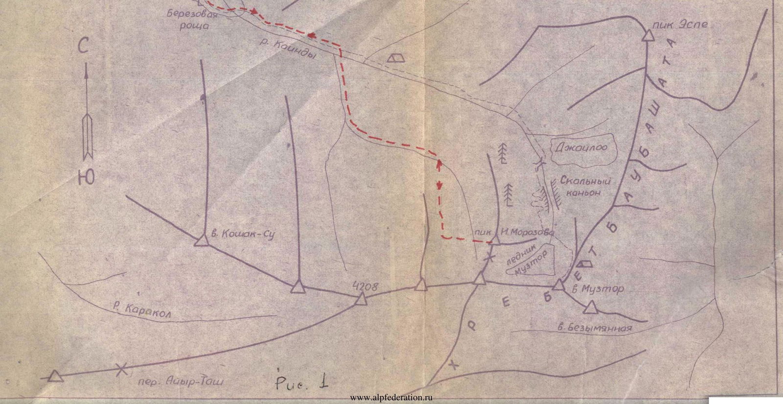 Fig. 1