
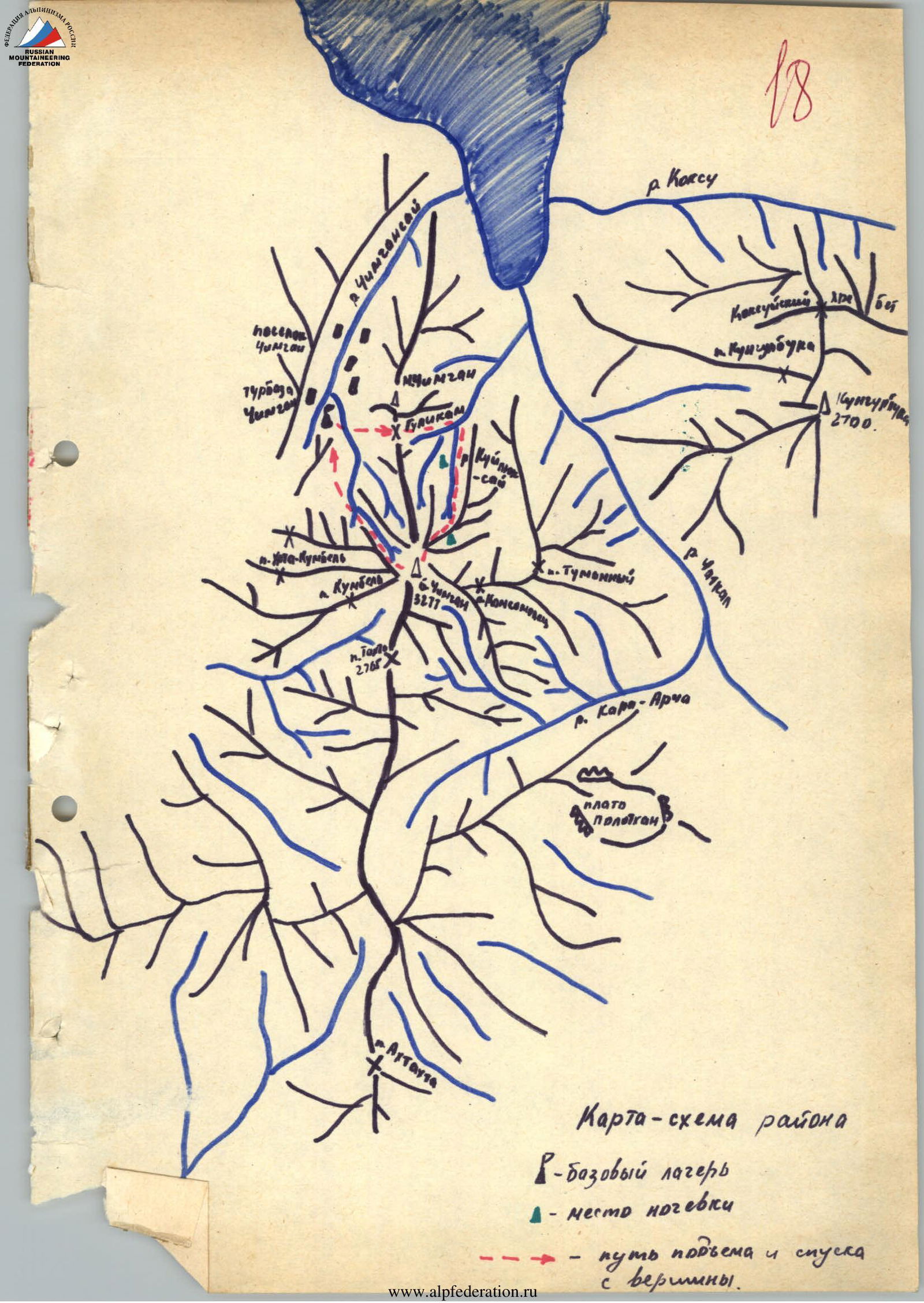
Map of the area ▲ – base camp △ – overnight stay location → – ascent and descent route from the summit.
Brief description of the route
- Brief description of the approach to the route
From the "Chimgan" tourist center, head upwards towards the GuliKam or Pesochny pass (1833 m). Then, through the pass, into the GuliKam gorge until the confluence of GuliKamsay and Kuilyuksay (1.5–2 hours). Here, the trail branches:
- one leads to the GuliKam gorges;
- the other — upstream along the Kuilyuksay riverbed to the start of the route — the base of the far-reaching left counterfort of the north-eastern wall of Bolshoy Chimgan.
The left counterfort of the north-eastern wall of Bolshoy Chimgan is a steep, mostly sheer rocky slope composed of grey limestone. To the right, the counterfort is bounded by a couloir that divides the entire wall into two parts. The right counterfort has a 4A category route, which starts much higher than the left one. To the left of the counterfort, very steep rocks are visible throughout the route, often turning into "ram's foreheads."
On the moraine in the upper part of Kuilyuksay — a bivouac. From the "Chimgan" tourist center to the bivouac is 2–2.5 hours.
- Description of the ascent to the summit of Bolshoy Chimgan via the left counterfort of the N-E wall
February 7, 1980 — Departure from the bivouac at 6:00 AM. From the bivouac, follow the Kuilyuksay riverbed to a large rocky massif that divides Kuilyuksay into two channels. Move upwards along the rocky massif via the right (orographic) channel, subsequently reaching the ridge of this rocky massif. Here, on a small platform overgrown with juniper bushes, the 1st control cairn is built, and the route begins (2.5–3 hours).
R0–R1. Up the wall made of grey limestone vertically to a juniper bush, where there is a small ledge. Climbing is above medium difficulty, protection via pitons. The general direction of movement is towards the base of the rusty rock spall that divides the wall into two parts. The rocks are snow-covered.
R1–R2. The rocks become significantly steeper, climbing is complex. Move left-upwards (landmark — a juniper bush) with an exit to a small ledge (2 m) 5 m above the juniper bush. Rocks are snow-covered, partially covered with ice.
R2–R3. Up the wall on its left part (15 m) with further movement, veering right, under a rocky tooth of yellow-grey color. At the base of the tooth, there is a ledge (4 m). A very challenging section. Rocks are steep, partially destroyed.
R3–R4. The tooth is passed on its left side, followed by an exit to its summit. Here, there is a narrow (1.5 m) long horizontal ledge, where the 2nd control cairn is built. Climbing is complex, protection via pitons.
R4–R5. Again, up the wall on its left part (15 m). Climbing is above medium difficulty. Then, straight up along the edge of an inclined slab (monolithic and snow-covered) with an exit under a rocky sentinel. At the base of the sentinel, there is a ledge (1–1.5 m). Climbing is difficult on this section. Backpacks are pulled.
R5–R6. Up the sentinel straight, with an exit to a ledge (3 m) on the summit of the sentinel. Rocks are destroyed and icy. Climbing is complex. Protection via pitons. Backpacks are pulled.
R6–R7. From the ledge, move straight up towards a grey wall with a ridge extending to the right. Rocks are destroyed and snow-covered, with many loose stones. Climbing is of medium difficulty, partially complex (short sections 3–4 m). Under the base of the wall, the 3rd control cairn is built.
R7–R8. Along the ledge from the 3rd control cairn, 3 m to the right, then straight up the wall with an exit in its upper part into an internal corner. Along the internal corner to the right, with an exit to a ledge transitioning from destroyed rocks covered with snow. On the right part of the wall, a rusty spall is visible, dividing the wall into two parts. Climbing on this section is complex. Backpacks are pulled. The ledge has a good spot for an overnight stay. Stop for the night at 17:00.
R8–R9. Departure from the bivouac at 9:00 AM. Move along the ridge in rope teams under the wall of grey color with small rocky outcrops. Rocks are snow-covered and destroyed.
R9–R10. Move:
- straight up 25 m,
- then left 20 m with an exit to a sharp ridge 15 m long.
Climbing is above medium difficulty. Protection via pitons.
R10–R11. Further movement:
- along the small ridge 15 m long with an exit under the base of a rocky ridge in the center of the wall,
- then along the rocky ridge 30 m.
Climbing is of medium difficulty. Protection via pitons.
R11–R12. Up the wall, oriented towards the rusty spall dividing the wall into two parts. Climbing is of medium difficulty. Many loose stones are covered with snow.
R12–R13. Further advancement goes left-upwards along the wall to a small ledge (1 m). Climbing is of medium difficulty. Rocks are snow-covered, partially icy.
R13–R14. From the ledge straight up along the internal corner with an exit to a sharp ridge of the left counterfort of the N-E wall. Climbing is of medium difficulty.
R14–R15. Further movement along the ridge in rope teams simultaneously to a small ledge, where the 4th control cairn is built.
R15–R16. Further movement along the ridge to the junction with the 3A category route. Movement in rope teams is alternating. Protection via outcrops and pitons.
R16–R17. Further movement along the pre-summit ridge towards the summit of Bolshoy Chimgan. Movement is simultaneous. Protection via outcrops. The time taken to reach the summit from the junction with the 3A category route is 3–3.5 hours. During the movement, a stop for rest is possible. The ridge has good spots for a bivouac.
R17–R18. Descent via the 1B category route (3–3.5 hours).
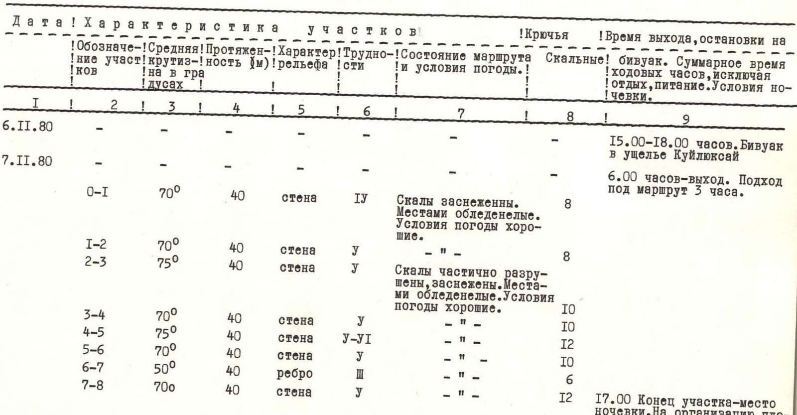
Table of main characteristics of the ascent to the summit of Bolshoy Chimgan via the left counterfort of the north-eastern wall
| Date | Section designation | Average steepness in degrees | Length (m) | Terrain character | Difficulty (category of section) | State of the route and weather conditions | Rock pitons | Time of departure, stop for bivouac. Total time of travel hours, excluding rest, food. Conditions of overnight stay. |
|---|---|---|---|---|---|---|---|---|
| November 6, 1980 | 15:00–18:00. Bivouac in the Kuilyuksay gorge | |||||||
| November 7, 1980 | 6:00 — departure. Approach under the route 3 hours. | |||||||
| R0–R1 | 70° | 40 | wall | 4 | Rocks are snow-covered. Partially icy. Weather conditions are good. | 8 | ||
| R1–R2 | 70° | 40 | wall | 3 | " | 8 | ||
| R2–R3 | 75° | 40 | wall | 3 | Rocks are partially destroyed, snow-covered. Partially icy. Weather conditions are good. | 10 | ||
| R3–R4 | 70° | 40 | wall | 3 | " | 10 | ||
| R4–R5 | 75° | 40 | wall | 4 | " | 12 | ||
| R5–R6 | 70° | 40 | wall | 3 | " | 10 | ||
| R6–R7 | 50° | 40 | ridge | 2 | " | 6 | ||
| R7–R8 | 70° | 40 | wall | 3 | " | 12 | 17:00. End of section — overnight stay location. Organizing the site took 1 hour. |
| Date | Section designation | Average steepness in degrees | Length (m) | Terrain character | Difficulty (category of section) | State of the route and weather conditions | Rock pitons | Time of departure, stop for bivouac. Total time of travel hours, excluding rest, food. Conditions of overnight stay. |
|---|---|---|---|---|---|---|---|---|
| November 8, 1980 | Departure from bivouac at 9:00 | |||||||
| R8–R9 | 30° | 40 | ridge | 2 | " | - | ||
| R9–R10 | 70° | 45 | wall | 4 | " | 8 | ||
| R10–R11 | 30° | 45 | ridge | 3 | " | 4 | ||
| R11–R12 | 50° | 50 | wall | 3 | " | 6 | ||
| R12–R13 | 55° | 40 | wall | 3 | " | 8 | ||
| R13–R14 | 55° | 15 | internal corner | 3 | " | 3 | ||
| R14–R15 | 25° | 40 | ridge | 2 | " | 3 | ||
| R15–R16 | 30° | 300 | ridge | 2 | " | 6 | ||
| R16–R17 | 20° | 1500 | ridge | 2 | " | - | ||
| R17–R18 | 25° | 2500 | ridge | 1 | " | - | 9:00–21:00 travel hours. II. |
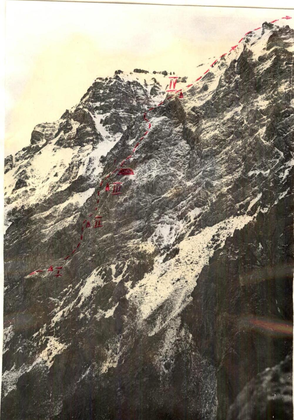
Route profile ▲ – Control cairns ■ – bivouac location
Brief geographical description and mountaineering characteristics of the object of ascent
One of the most visited areas by mountaineers and tourists from Tashkent and other cities of the UzSSR is the watershed ridge extending north from the Kyzylnur massif and ending at the Bolshoy Chimgan peak (3277 m).
To the summit of Bolshoy Chimgan, mountaineering routes from 1 to IV category of difficulty have been laid from all sides. Snow covers the upper slopes of Bolshoy Chimgan until August.
The Chimgan tract has good connections with Tashkent. A scheduled bus Tashkent–Burchmulla, passing through the cities of Chirchik, Gazalkent, and several villages, will bring you to the "Chimgan" tourist center of the Tashkent Regional Council for Tourism and Excursions in 2.5 hours.
In the Chimgan tract, from April to June, many sports alpine clubs conduct alpine gatherings where mountaineers replenish their ranks and check and practice technical techniques for moving across mountainous terrain.
The rocky walls and massifs of Bolshoy Chimgan attract rock climbers. In the Chimgan tract, competitions in slalom and rock climbing are often held.
The development of Bolshoy Chimgan began in the 60s when the first ascents to its summit were made by mountaineers from Tashkent.
Currently, more than 15 routes have been laid to the summit of Bolshoy Chimgan, some of which are classified. Each year, the number of athletes visiting the Chimgan tract, which now represents a large sports arena as well as a recreation zone, grows.
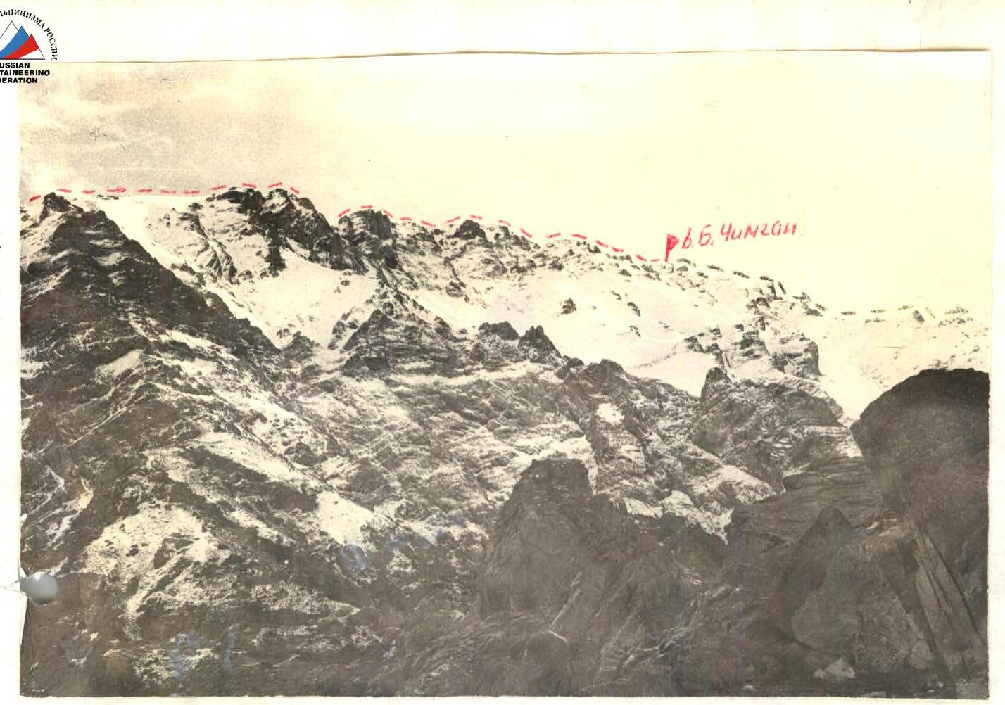
Pre-summit ridge.
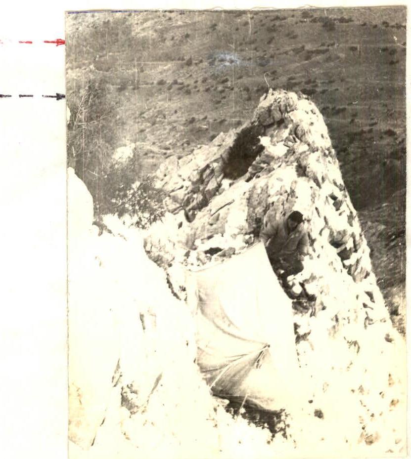
Bivouac on the route.
Comments
Sign in to leave a comment