Sалават via the North Ridge, cat. 2A
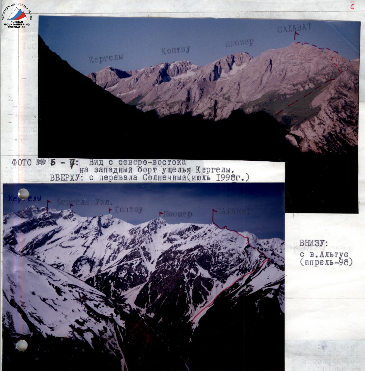
When ascending from the "1860" fork along the Kergely River valley, distant peaks (Kergely and Koptau) initially come into view, and at an altitude of 2000 m, closer to the Koptjailyau valley, the powerful slabs of the northern face of Salavat's eastern ridge and its entire typically "table-like" massif become visible, with the spur of Peak I. Roshchin being the closest to "1860".
After crossing the river and traversing along the left (hereinafter - orographic) bank of the Kergely River, the ascent route becomes visible from the right; initially, it is a very wide, arcuate couloir narrowing upwards to the right. The "3000" pass is visible above it, and to the left is the profile of the north ridge with the "Treугольник" (Triangle) gendarme. The summit is hidden behind the junction of the north and east ridges. On the left, in the lower part of the eastern ridge, a couloir descends directly towards the observer, leading to the right of the "Zub" (Tooth) gendarme onto a connecting ridge, from which a Shk/sl (Difficult climb) route is possible (we explored it but did not complete it due to several reasons).
If one ascends further along the Kergely River, from the "2320" lake, the relatively even south ridge of Salavat and the "3300" pass will become visible (from right to left), from which the north ridge of Peak Pioner (cat. 2A), classified in 1962, begins. We traversed this ridge for reconnaissance. It turned out that the aforementioned even south ridge was overloaded with cornices; hence, we chose the north ridge for the ascent.
Technical description
Do not approach the northern wall of the eastern ridge in the couloir: rockfall is possible early in the morning (avalanches in spring).
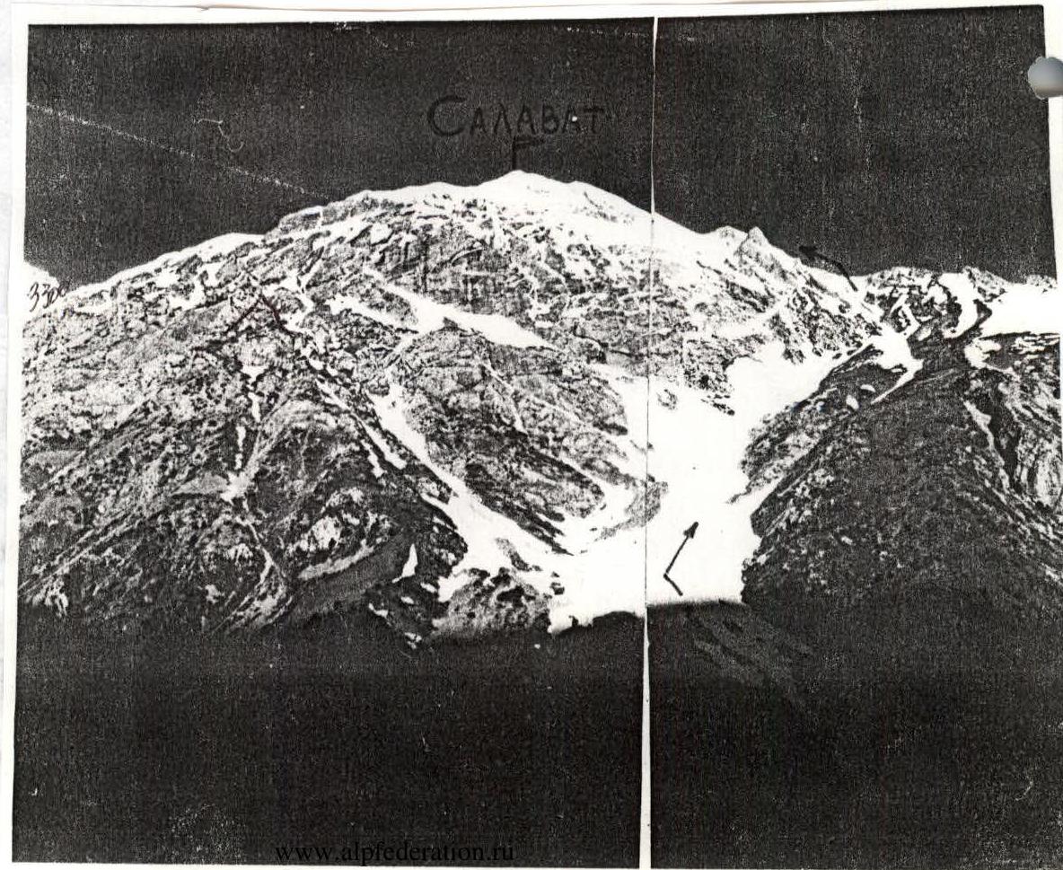
The arcuate couloir, approximately 2000 m long, with slopes up to 40° (scree, snowfields, outcrops of destroyed rocks), leads to the "3300" pass or to its left. The summit is still not visible from here.
A rope is used to bypass the "Treугольник" (Triangle) gendarme from the west: in spring, there is a snowy slope, and in summer, there are outcrops of steep rocks. Then, there are 300 m of rocks, cat. 1-2: initially, an ascent along the north ridge and a 15 m descent along its wall at 50°, followed by a traverse along the ridge to its junction with the eastern ridge.
The summit and steep slopes to the right of the ridge in front of it are now visible. From the junction, there is a descent into a hollow and an ascent along rocks, PC (Difficult climb)/sl, 150 m, under a tower. The exit onto the summit tower is via an internal corner, 20 m, 60°, Shk/sl.
Descent - either northwards, via the ascent route, or after descending on a rope to the southeast, through scree-filled couloirs to the "2320" lake, and then down along the trail.
Photo #8: Morning view of Salavat from the east (April '98). The "3300" pass is visible at the left edge.
Class: ROCK Region: Tian Shan, Ugam Ridge Peak: SALAVAT Height: 3446 m (according to the map) Route and proposed category of difficulty: via the North Ridge of Salavat 3446, cat. 2A (from the ridge, V. Shadrin, '98) Height difference: total 1350 m, including N ridge - 150 m Distance: total 2500 m, including N ridge - 550 m Steepness: up to 40° Protection: via ledges (no old pitons) Climbing hours: to the summit - 5 (from the "1860" bivouac - 6) Leader: Ildrin Viktor Aleksandrovich (CMS) Participants: Agafonov Anat. Kondr. (P), Kozlov Al-dr Boris. (Sh), Sedanov N. V. The route was not counted due to a violation of the release conditions

