
169
Traverse Description
Peak Tashtambektor — Onduuchoku — Sherkhan South — Sherkhan Central — Sherkhan North with ascent to Peak Tashtambektor via the North wall, accomplished by the MOS DSO "ZENIT" team
July 27, 1977 – July 31, 1977
(approximately 5B category of complexity) www.alpfederation.ru ↗
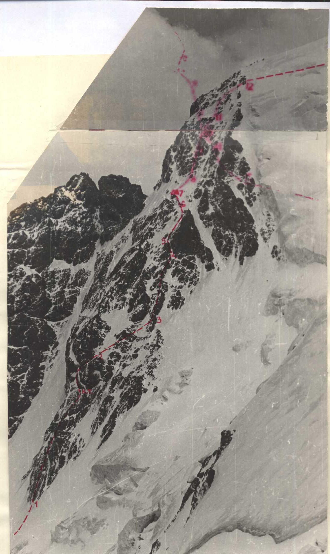
Photo 1. Profile-detailed wall of Peak Tashtambektor

| Date | Designation | Average steepness, in ° | Length, in m | Character of relief | Difficulty | Condition | Weather conditions | Rock | Ice | Sling |
|---|---|---|---|---|---|---|---|---|---|---|
| July 28, 1977 | R0–R1 | 35 | 80 | Ice slope | II | Slope is snow-covered | good | - | 2 | - |
| R1–R2 | 65 | 160 | Rocky counterforce | IV | Icy, partially snow-covered | - | 15 | - | - | |
| R2–R3 | 45 | 60 | Ice slope with rocky island | III | Rocks are icy | satisfactory | 4 | - | - | |
| R3–R4 | 65 | 140 | Rocky outer angle with ice shelves | IV | местами лёд и снег на скалах | - | 16 | - | - | |
| R4–R5 | 80 | 40 | Rocky couloir | V | Ice formed on rocks | poor: snowfall, wind | 5 | 1 | - | |
| R5–R6 | 65 | 80 | Ice slab | V | Ice is partially snow-covered | - | 2 | 12 | - | |
| R6–R7 | 50 | 40 | Rocky islands in ice | IV | Rocks are icy and snow-covered | - | 4 | 2 | - | |
| July 29, 1977 | R7–R8 | 60 | 80 | Ice slab | V | Ice is partially snow-covered | good | - | 10 | - |
| R8–R9 | 70 | 80 | Rocky wall with ice shelves | V | Rocks are monolithic, partially ice-covered | - | 9 | - | - | |
| July 30, 1977 | R9–R10 | 65 | 40 | Rocky wall with ice shelves | V | Monolithic rocks partially ice-covered | good | 5 | 2 | - |
| R10–R11 | 60 | 40 | Rocky islands in ice | V | Rocks are snow-covered | satisfactory | 3 | 3 | - | |
| R11–R12 | 50 | 80 | IV | Rocks are snow-covered and icy | - | 3 | 4 | - | ||
| R12–R13 | 45 | 240 | Ice-snow slope | IV | Upper part of ice slope is snow-covered | poor: snowfall, wind | - | 21 | - | |
| R13–R14 | 50 | 80 | Rocky vaguely expressed ridge | IV | Rocks are monolithic, partially ice-covered | poor, thunderstorm | 9 | - | - | |
| R14–R15 | 30 | 160 | Rocky vaguely expressed ridge | III | местами лёд и снег на скалах | good | 10 | - | - | |
| R15–R16 | 20 | 80 | Rocky ridge | Snow-covered | - | 3 | - | - | ||
| R16–R17 | 60 | 160 | Rocky counterforce | IV | Monolithic rocks, partially ice-covered | - | 17 | - | - | |
| R17–R18 | 70 | 200 | Rocky wall | V | - | - | 16 | - | - | |
| R18–R19 | 10–20 | 80 | Snow ridge | I | - | - | - | - | belay via ice axe | |
| R19–R20 | 35 | 40 | Ice gendarme | IV | - | - | - | 3 | - | |
| R20–R21 | 40–50 | 500 | Rocky-snow ridge | V | Rocks are partially destroyed | - | 6 | - | - | |
| R21–R22 | 40 | 200 | Snow ridge with monolithic rock outcrops | - | - | 3 | - | - | ||
| July 31, 1977 | R22–R23 | 0–10 | 600 | Rocky ridge | II | Rocks are partially destroyed | - | 3 | - | - |
| R23–R24 | 0–10 | 700 | Scree ridge | I | - | - | - | - | simultaneous movement | |
| R24–R25 | 30–40 | Descent via scree slabs and couloirs | I-II | Scree slabs and couloirs | - | - | - | - |
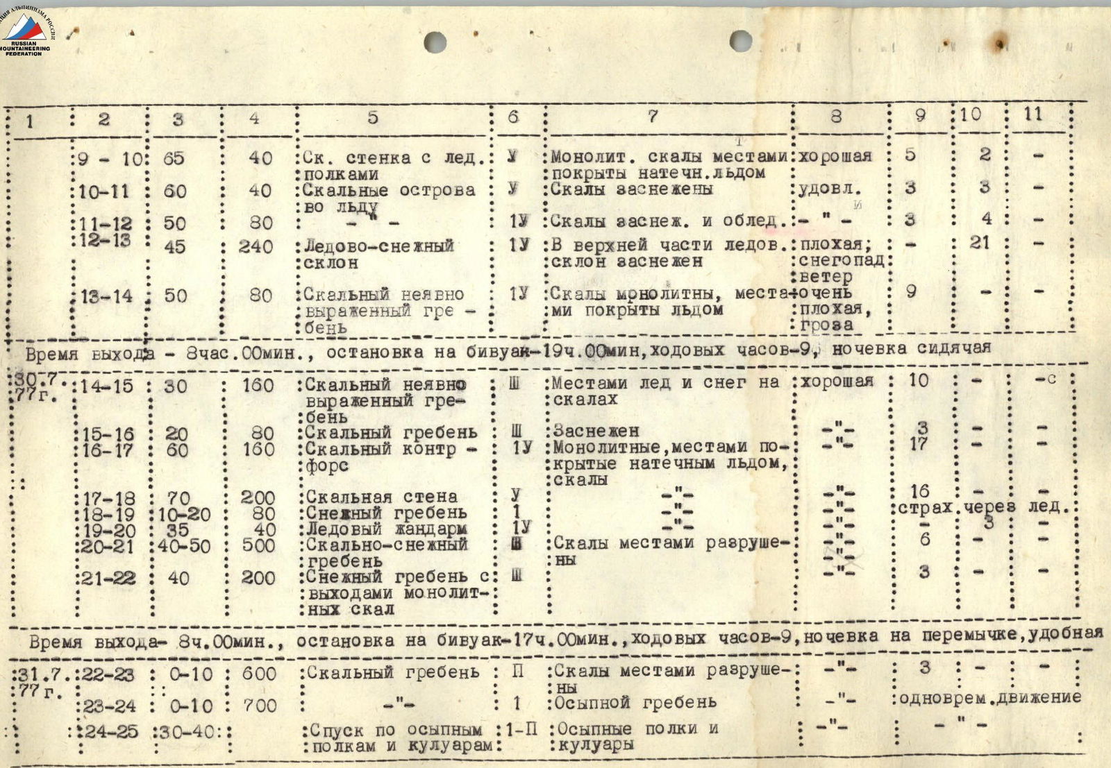
Departure time — 8:00
- stop for bivouac — 17:00
- hours of climbing — 9
- overnight stay on a saddle, comfortable
Brief Description of the Traverse
Peak Tashtambeektor — Onduuchoku — Sherkhan South — Sherkhan Central — Sherkhan North with ascent to Peak Tashtambeektor via the North wall
The peaks are located in the Kyrgyz SSR within the Terskey-Alatau ridge. The base camp of the team was situated in the upper reaches of the Tashtambeektor gorge (approximately 45 minutes walking time from the base camp to the Tashtambeektor glacier). It takes about 1.5 hours to reach the assault camp located on the right moraine of the Tashtambeektor glacier from the base camp. From the overnight stay location to the snowy base of the North wall of Tashtambeektor, it takes around 2 hours.
The path goes along the glacier, which is open in the lower part and closed in the upper part. The glacier is abundant with crevices and requires serious attention when crossing. In the upper part, when approaching the North wall, it is necessary to cross two wide crevices via snow bridges. Careful belaying is required!
After the crevices, an ice-snow slope leads to the base of the wall (80 m, 35°, 2 ice pitons, section R0–R1).
The wall route begins with overcoming a rocky counterforce, the rocks of which are quite complex, heavily iced, and partially snow-covered (160 m, 65°, 15 rock pitons, section R1–R2). The counterforce ends with an ice slope with rocky islands. The rocky outcrops are monolithic, covered with ice and partially snow-covered. The ice slope is traversed left-up-right (60 m, 45°, 4 rock pitons, section R2–R3) towards a clearly defined rocky outer angle (140 m, 65°, 16 rock pitons, section R3–R4). The rocks are monolithic with a small number of cracks, partially iced, and covered with a thin (2–3 cm) layer of snow. The angle leads to the base of a steep rocky couloir filled with ice (40 m, 80°, 5 rock and 1 ice piton, section R4–R5). The couloir leads to the base of an ice slab, partially slightly snow-covered (80 m, 65°, 2 rock and 12 ice pitons, section R5–R6). The ascent up the slab is done from right-up-left towards the outcrops of black rocks. The weather deteriorated sharply at this time, with heavy snowfall and strong wind, and a significant drop in temperature. The rocky outcrops are large islands composed of monolithic rocks, partially iced. When overcoming this section (40 m, 50°, 4 rock and 2 ice pitons, section R6–R7), attempts to find a convenient place for a bivouac were unsuccessful. A sitting bivouac had to be organized on top of a rocky island, with organization taking place in very poor weather conditions (strong wind, snowfall).
Overcoming all sections of the first day of ascent required 10 hours of intense and complex psychological work. Starting from section R3–R4, the ascent was carried out in a "rope-team" configuration, with the first person in the lead rope being unloaded. The same tactics were used in the following days when ascending to Peak Tashtambeektor and descending until the start of section R17–R18 (excluding section R15–R16).
The next working day begins with overcoming a steep ice slab (80 m, 60°, 10 ice pitons, section R7–R8). The weather is good. The ice has an unpleasant structure: when hammering in pitons like VCSSP or using screw-in pitons, it is possible to break off large ice chunks.
The ice slab leads to the base of a rocky wall intersected by several characteristic ice shelves. After the snowfall of the previous day, the shelves are snow-covered. The wall is formed by monolithic rocks with a small number of cracks; the rocks are partially covered with ice (80 m, 70°, 9 rock pitons, section R8–R9).
Further, the wall becomes somewhat gentler — (40 m, 65°, 5 rock and 2 ice pitons, section R9–R10) and ends with a series of rocky islands in ice (40 m, 60°, 3 rock and 3 ice pitons, section R10–R11).
A more straightforward section, formed by a series of rocky islands, leads to an extended ice-snow slope (80 m, 50°, 3 rock and 4 ice pitons, section R11–R12).
The ice-rock slope (240 m, 45°, 21 ice pitons, section R12–R13) is traversed towards the summit. The weather deteriorates sharply, with wind carrying snow grains along the slope, and a thunderstorm beginning somewhere near the summit. When the group moved along a rocky, gently expressed ridge (80 m, 50°, 9 rock pitons, section R13–R14), a convenient place for a bivouac could not be found, and further movement was impossible due to the thunderstorm.
Bivouac — on a rocky ledge, sitting. The group spent 9 hours on the second day of ascent overcoming sections R7–R14.
The morning of the third day of ascent rewarded the group with excellent weather, although it was very cold.
A gently expressed rocky ridge led to the summit, with monolithic rocks partially covered with ice and snow:
- 160 m, 30°, 10 rock pitons, section R14–R15.
A short snow-covered ridge leads directly to the summit:
- 80 m, 20°, 3 rock pitons, section R15–R16.
After a 15-minute rest at the summit, the group began descending towards Peak Onduuchoku and the Sherkhan massif.
The descent began along a rocky counterforce composed of monolithic rocks, partially covered with ice:
- 160 m, 60°, 17 rock and 1 ice piton, section R16–R17.
The counterforce ends with a narrow ice belt, which crowns a steep wall leading to a snowy saddle between Peak Tashtambeektor and Onduuchoku:
- 200 m, 70°, 16 rock pitons, section R17–R18.
To overcome this section, 5 rappels were organized (9 pitons were left on the route).
The snowy ridge is not difficult:
- 80 m, 10°–20°, belay via ice axe, section R18–R19 — and leads to the base of a massive ice gendarme:
- 40 m, 35°, 3 ice pitons, section R19–R20.
The gendarme is overcome directly head-on. From the gendarme, the route lies along a rocky-snow ridge of medium difficulty:
- 500 m, 40°–50°, 6 rock pitons, section R20–R21 — which turns into a purely snowy ridge with individual outcrops of monolithic rocks:
- 200 m, 40°, 3 rock pitons, section R21–R22.
The ridge leads to a wide snowy saddle, where it is convenient to organize a bivouac. 9 hours were spent on the third day.
The ascent to Peak Sherkhan South is not difficult, and then a rocky ridge, partially composed of destroyed rocks, leads to Peak Sherkhan Central:
- 600 m, 0°–10°, 3 rock pitons, section R22–R23.
Numerous gendarmes on the ridge are bypassed on the left along the way.
From Peak Sherkhan Central to Peak Sherkhan North, a simple scree ridge leads:
- 700 m, 0°–10°, simultaneous movement, section R23–R24.
The descent from Peak Sherkhan North — directly to the glacier and moraine via wide scree couloirs located to the right along the way from the counterforce leading from the summit to the glacier.
Regarding the overall characterization of the route, it should be noted that, in our opinion, the complexity, volume of rock and ice work of the ascent to Peak Tashtambeektor via the North wall with descent to the saddle corresponds to a 5B category of complexity route.
Recommendations for subsequent climber groups:
- Crampons are necessary for all sections.
- The route should be equipped with 30 rock pitons and 20 ice pitons.
- Special attention should be paid to the instability of the weather in the area of Peak Tashtambeektor and frequent thunderstorms at the summit, and accordingly, to the timely organization of bivouacs on the route.
Team Captain
Participants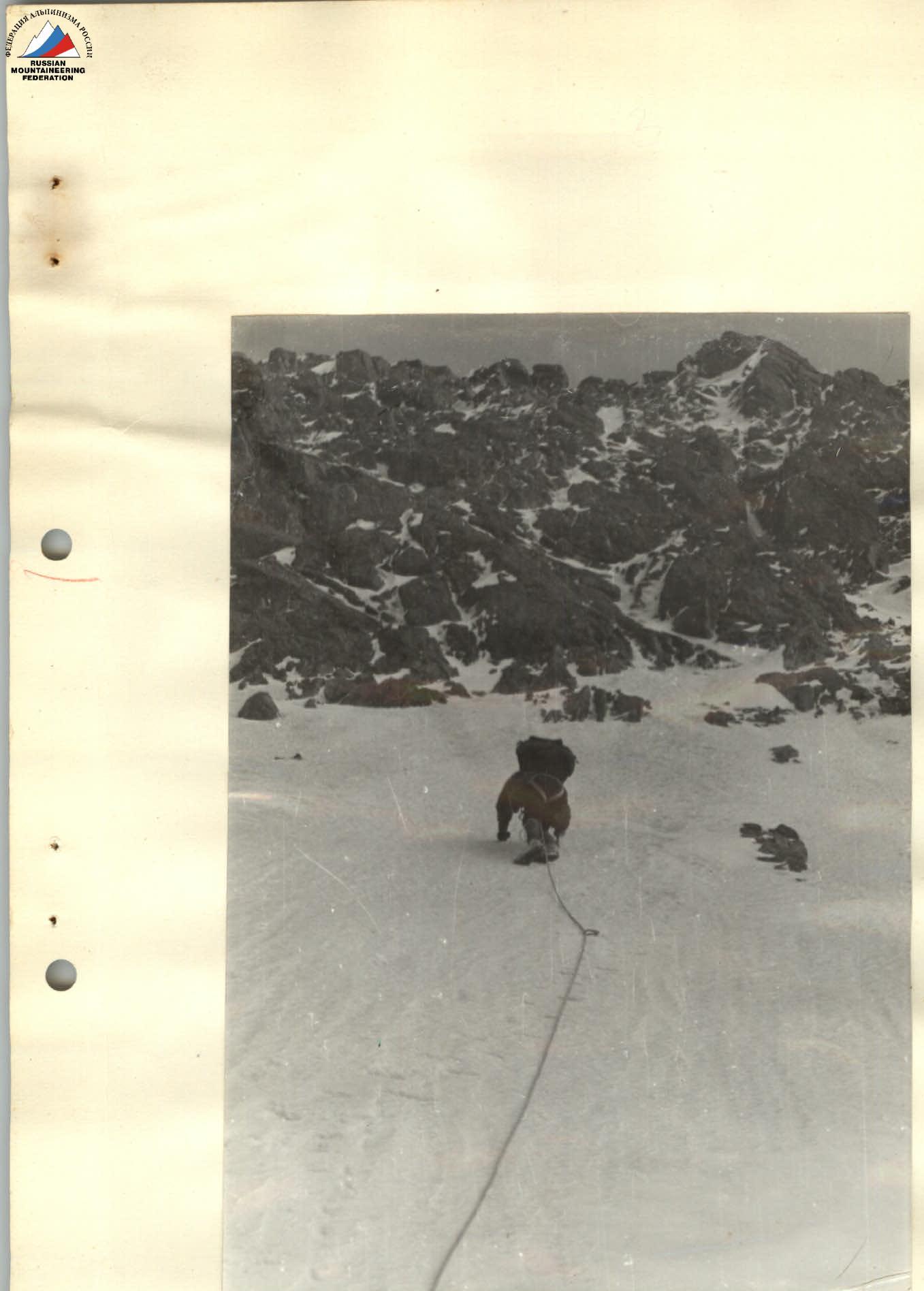
Photo 4. Overcoming the ice belt (section R6–R7)
Comments
Sign in to leave a comment