
Ascent Passport
on Mt. Slonionok via the NW buttress (first ascent)
- Ascent class
- Ascent area
- Peak, its height, route
- Estimated difficulty category
- Route characteristics: height difference, length of sections with 5–6 difficulty grade, average steepness
- Number of pitons driven for belaying, for creating belay stations
- Number of climbing hours
- Number of overnight stays and their characteristics
- Full name of the team leader, participants, and their qualification
- Coach of the team
- Date of departure and return from the route
Technical Tian-Shan, Terskey Ala-Too, Slonionok, NW buttress, 4726 m, 5B difficulty category, 1156 m, 650 m, 72°
| Rock | Ice | Bolt | |
|---|---|---|---|
| For belaying | 166 | 75 | – |
| For creating belay stations | 22 | 8 | – |
40 climbing hours 1 sitting + 1 lying overnight stay
Ascent participants:
- Usmanov S.F. — Candidate Master of Sports
- Kudashkin D.V. — Master of Sports
- Boshman V.F. — Candidate Master of Sports
- Vakurin V.V. — 1st sports category
- Slepushkin E.F. — Master of Sports
Ascent period: August 16–20, 1978

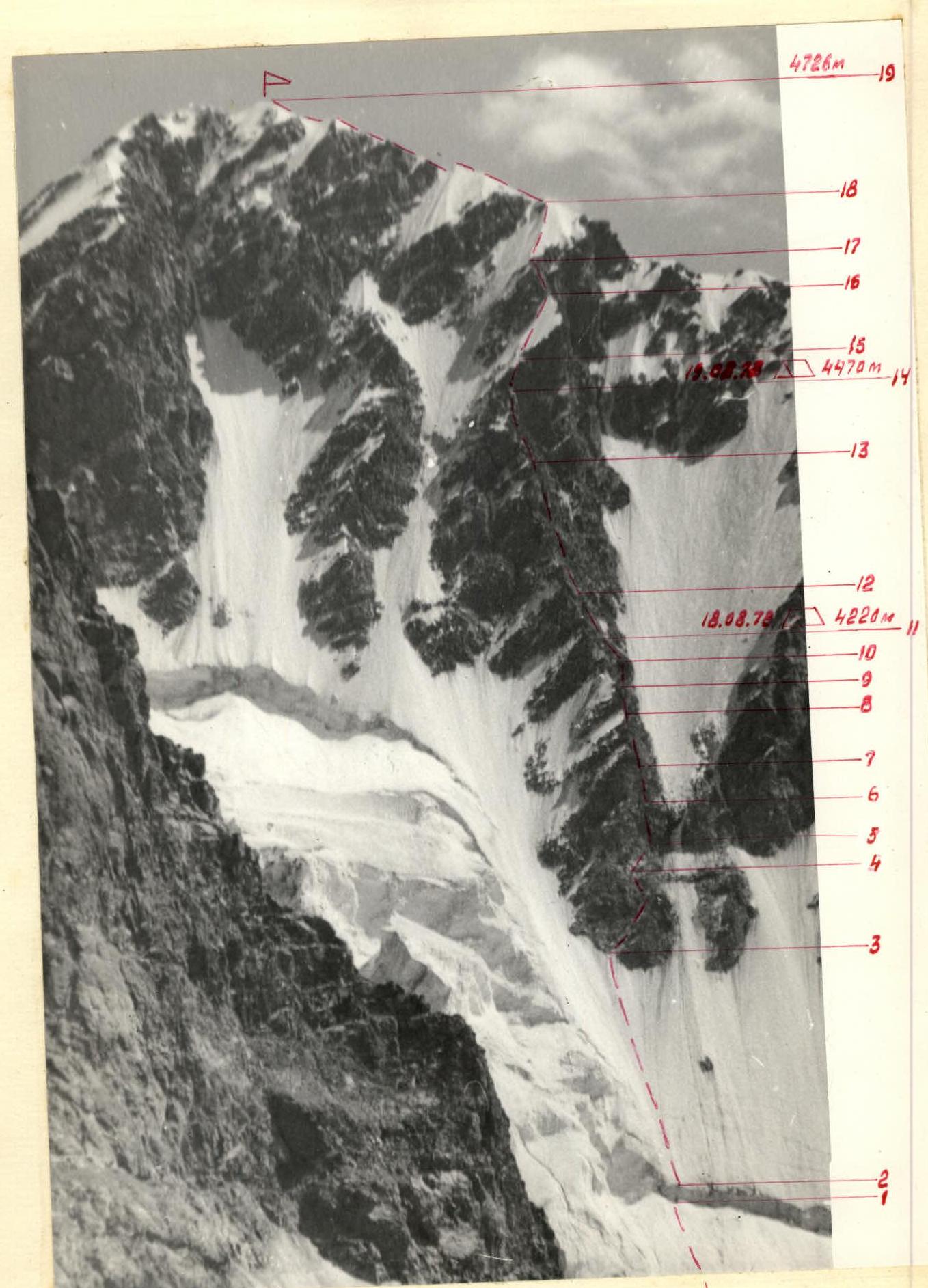
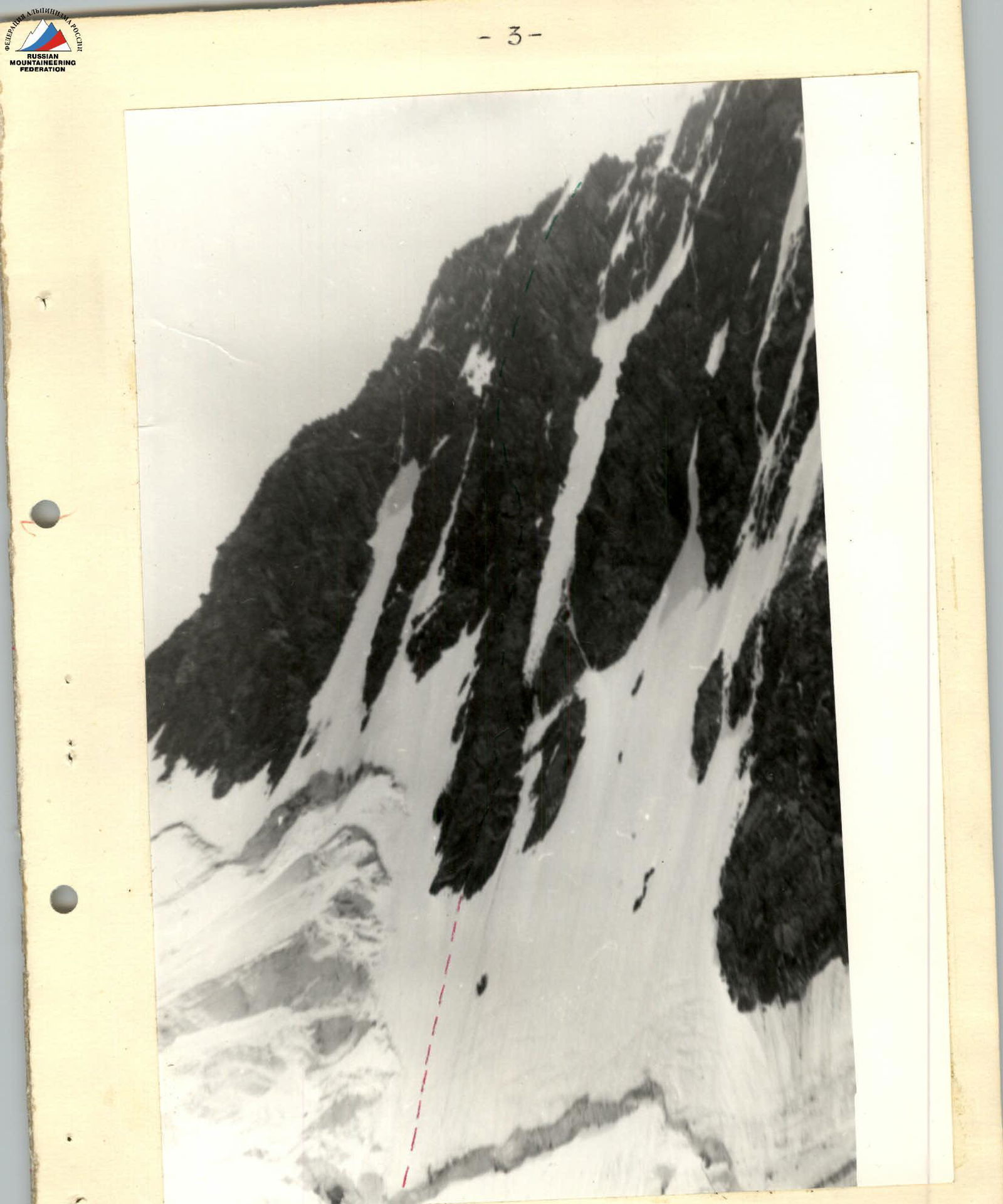
Ascent Route
Route Profile

Table
of main characteristics of the first ascent route on Mt. Slonionok via the NW buttress
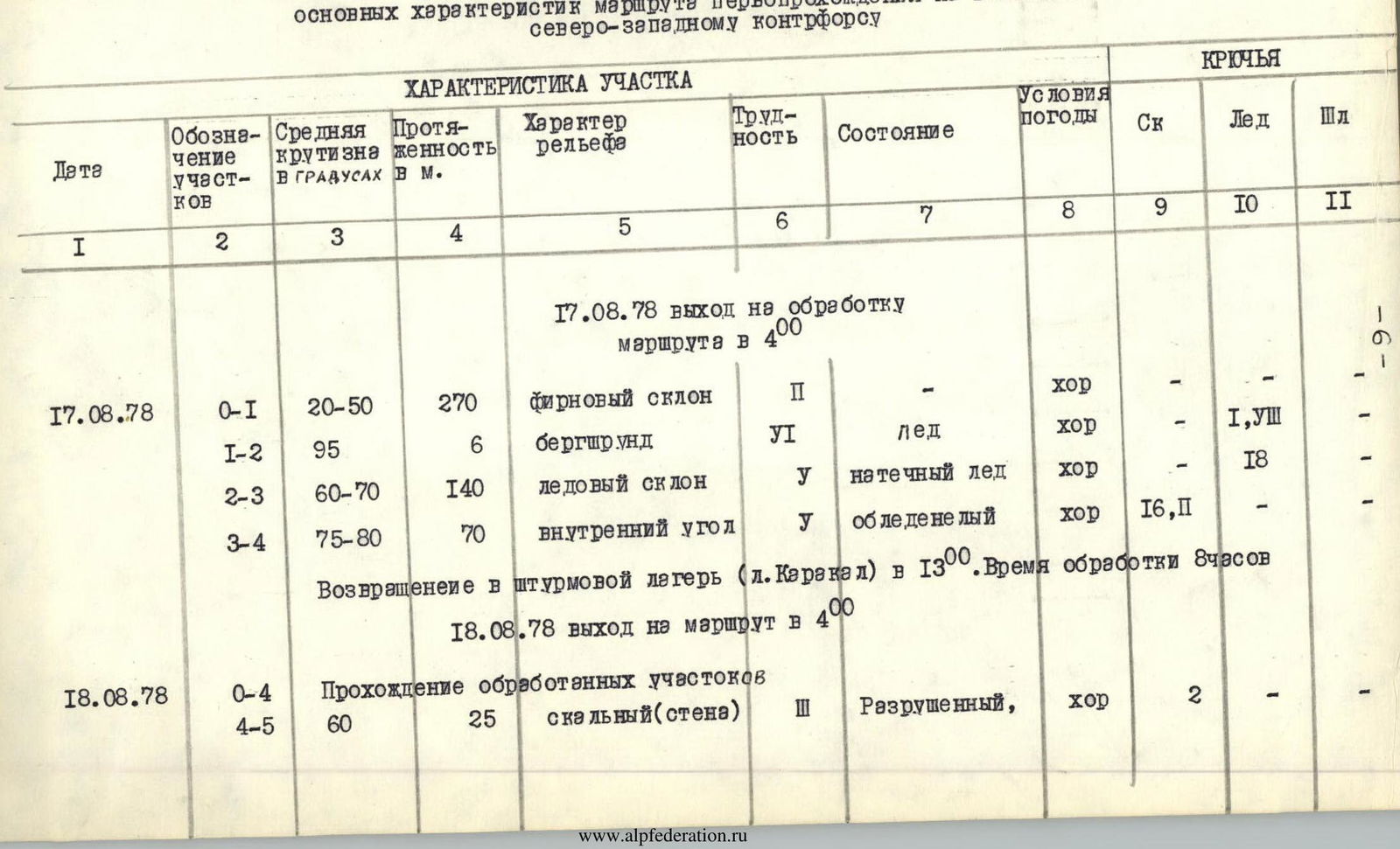
| Date | Section designation | Average steepness in degrees | Length in m | Terrain character | Difficulty | Condition | Weather conditions | Pitons (rock) | Pitons (ice) | Pitons (bolt) |
|---|---|---|---|---|---|---|---|---|---|---|
| August 17, 1978 | Departure for route processing at 4:00 | |||||||||
| R0–R1 | 20–50 | 270 | Firn slope | I | – | good | 1 | – | – | |
| R1–R2 | 95 | 6 | Bergschrund | VI | Ice | good | – | 1, VII | – | |
| R2–R3 | 60–70 | 140 | Ice slope | V | Overhanging ice | good | – | 18 | – | |
| R3–R4 | 75–80 | 70 | Inner corner | V | Icy | good | 16 | P | – | |
| Return to the assault camp (Lake Karakol) at 13:00. Processing time – 9 hours. | ||||||||||
| August 18, 1978 | Departure for the route at 4:00 | |||||||||
| R0–R4 | Passage of processed sections | |||||||||
| R4–R5 | 60 | 25 | Rock wall | III | Destroyed | good | 2 | – | – | |
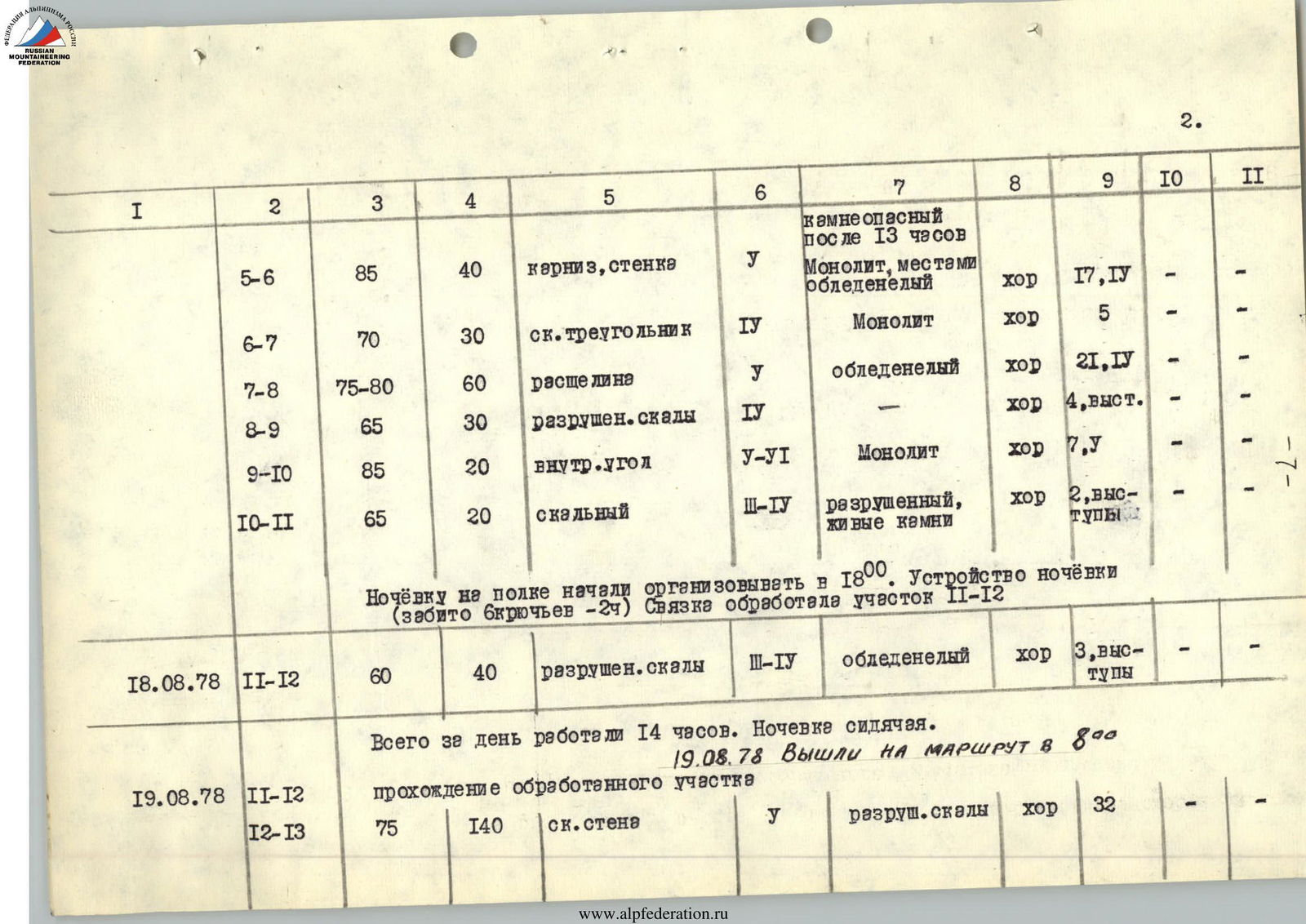
| R5–R6 | 85 | 40 | Cornice, wall | V | Rockfall-prone after 13:00. Monolith, partially icy | good | 17 | IV | – | |
| R6–R7 | 70 | 30 | Rock triangle | IV | Monolith | good | 5 | – | – | |
| R7–R8 | 75–80 | 60 | Crevice | V | Icy | good | 21 | IV | – | |
| R8–R9 | 65 | 30 | Destroyed rocks | IV | – | good | 4 | Protrusions | – | |
| R9–R10 | 85 | 20 | Inner corner | V–VI | Monolith | good | 7 | V | – | |
| R10–R11 | 65 | 20 | Rock | III–IV | Destroyed, loose rocks | good | 2 | Protrusions | – | |
| Started organizing an overnight stay on a ledge at 18:00. Setting up a bivouac (24 pitons driven). The rope team processed the R11–R12 section | ||||||||||
| August 18, 1978 | R11–R12 | 60 | 40 | Destroyed rocks | III–IV | Icy | good | 3 | Protrusions | – |
| Total working time for the day – 14 hours. Sitting overnight stay. | ||||||||||
| August 19, 1978 | Departure for the route at 8:00. | |||||||||
| R11–R12 | Passage of the processed section | |||||||||
| R12–R13 | 75 | 140 | Rock wall | V | Destroyed rocks | good | 32 | – | – | |
| R13–R14 | 75–80 | 90 | Cornice, inner corner | V–VI | Filled with ice | satisfactory | 28 | V | – | |
| Did not plan for an overnight stay, departed at 18:30. Setting up a bivouac (8 pitons driven – 1 hour). Total working hours for the day – 10. Semi-reclining overnight stay. | ||||||||||
| August 20, 1978. Departure for the route at 8:15. | ||||||||||
| August 20, 1978 | R14–R15 | 65 | 30 | Rock ridge | IV–V | Icy | good | 6 | I | I |
| R15–R16 | 65–70 | 80 | Ice slope | V | Overhanging ice | good | – | 12 | I | |
| R16–R17 | 85 | 40 | Inner corner with negation | V | Snow-covered, icy | good | 9 | I | – | |
| R17–R18 | 60–50 | 110 | Ice ridge | V–IV | – | good | – | 12 | – | |
| R18–R19 | 20 | 300–400 | Snow-ice ridge | V | Abundant cornices | satisfactory | – | 8 ice screws | – |
Reached the summit at 12:30. Descent via Metallurg Pass took 4 hours 30 minutes.
Steel pitons driven:
- for belaying: 152
- for organizing belay stations: 22
- for organizing overnight stays: 14
Ice screws screwed:
- for belaying: 75
- for organizing belay stations: 8
2 loops made.
Total working time for the day:
- ascending to the summit: 6 hours
- descending: 4 hours 30 minutes
- total: 10 hours 30 minutes
Total time spent on the route: 40 climbing hours (including the day of preliminary processing). Time spent on organizing overnight stays on the route: 3 hours.
Mt. Slonionok, NW buttress. 5B difficulty category (estimated)
Description of the Area
Mt. Slonionok is located in the middle part of the Terskey Ala-Too ridge, between the main peaks of the ridge — Karakol and Dzhigit. The ridge is part of the Tian Shan mountain system and stretches in a latitudinal direction south of Lake Issyk-Kul. The snow line on the northern slopes of the ridge lies at an altitude of 3600–3700 m. To the west, the ridge is connected to a series of ridges bounded to the north by the Naryn River. To the east, it is connected to the Sary-Dzhas ridge with its highest peak — Peak Semenov (5816 m). The Karakol valley, where the Ala-Too alpine camp is located, stretches from north to south, starting directly behind the city of Karakol and extending more than 50 km to the Karakol glacier.
The climatic conditions of the Central Tian Shan are less favorable for climbing than those of the Pamir region. The Karakol valley is one of the areas with the highest precipitation in Tian Shan. The peaks of Karakol (5280 m) and Dzhigit (5170 m) collect all the moisture from Issyk-Kul brought by the winds. Characteristic weather conditions in the area include deterioration of weather in the second half of the day, with the arrival of clouds, rain starts, which turns into snow at higher altitudes. By evening, the snow usually stops, and the cycle repeats in the morning. Of course, there are pleasant exceptions (end of July – beginning of August) when stable weather persists for several days.
Preparation for the Ascent
The final composition of the team was formed in the 1978 season, but its participants had been known for their joint work in the Ala-Archa alpine camp, participating in annual year-round events held in Kyrgyzstan. This year, the participants made joint ascents to:
- Peak Elbrus (Kudashkin-Boshman)
- Peak Kyrgyzstan (Kudashkin-Vakurin) as part of the "Burevestnik" Central Council's sports society championship — a first ascent, estimated by the participants as a 6B category route.
- Peak Lenin via the northern wall (Ryabukhin's route – silver medal at the USSR championship) – Boshman-Usmanov rope team, second passage of the route.
The idea for this ascent was conceived in 1976 when the team members were in the Karakol area at the base of the Kyrgyz Sports Committee. A detailed review of the route and refinement of the tactical ascent plan were carried out in 1978 during the descent from Peak Lyungit on July 30, 1978, and on August 12, 1978, during Boshman V.'s exit to the high-altitude zone to conduct a debriefing of the ascent by the camp participants together with Kudashkin I.
Description of the Ascent
On August 16, 1978, the team departed for the ascent. From the Ala-Too alpine camp, they ascended along the tongue of the Karakol glacier (4 hours). Along the right moraine, they climbed up to the glacier and moved upstream towards Mt. Slonionok. The assault camp was set up on the right bank moraine opposite the Metallurg Pass. Total travel time – 7 hours.
On August 17, 1978, the group departed for route processing at 4:00. From the overnight stay, they moved perpendicular to the Slonionok-Karakol ridge, to the right of the pass, bypassing the ice field. Not reaching 150–200 m to the snowy slopes of the ridge, they made a sharp turn left under the NW buttress of Mt. Slonionok ("rest on the slope").
The beginning of the route is a snow-free slope with a length of 250–270 m, with a gradual increase in steepness up to 80° under the bergschrund (section R0–R1). It is passed in crampons. An early departure is necessary due to falling rocks on both sides of the buttress. The bergschrund (6 m, 95°, section R1–R2) is passed with ladders using artificial support points. The ice slope to the snow patch is 140 m with a steepness of 60–70°, is rockfall-prone, and requires fast movement with reliable belaying (section R2–R3). The exit is into the central part of the buttress, into a weakly expressed icy inner corner. Along the icy inner corner (section R3–R4, 75–80°, 70 m), the ascent is made to an inclined shelf, a protrusion of the buttress.
Having set up a belay, breaking the control cairn, the group descended to the assault camp at 13:00.
On August 18, 1978, they departed for the route at 4:00.
After passing the R0–R4 section via the belay, along the inclined shelf and protrusion, they exited into the left part of the rusty-colored wall (section R4–R5, 25 m, 60°) under the rusty bastion. Under the bastion, a 0), they passed a cornice 0.5 m with the help of ladders and then along a crevice (section R5–R6, 40 m, 85°), after which they made a traverse to the right 10 m along a strongly steep slope of 75°, onto a rock triangle (section R6–R7, 30 m, 70°). Along a crevice 3 cm to 10 cm wide, 15–18 m long, straight up (section R7–R8, 60 m, 75–80°). A ledge where the team could gather in threes. Ropes were pulled up. From the ledge, left and up along destroyed, rockfall-prone rocks (section R8–R9, 30 m, 65°), they exited under the rusty wall of the buttress. The wall (section R9–R10, 20 m, 85°) is passed along an inner corner in the left part of the wall. Climbing is very difficult, with the creation of artificial support points. Further, straight up along strongly destroyed rocks (section R10–R11, 20 m, 65°), they exited onto an inclined shelf. The Boshman-Vakurin rope team prepared a site, organizing an overnight stay. Usmanov-Kudashkin processed the next weakened rope section of rocks (section R11–R12, 40 m, 60°), which began from the shelf and went straight up to the middle rusty-colored rock. Having gathered on the shelf, the group spent the night sitting in a tent due to the significant inclination of the shelf.
On August 19, 1978, they departed for the route at 8:00.
Having passed the processed R11–R12 section, they exited onto the upper rock triangle. Along the center of the strongly steep triangle (section R12–R13, 140 m, 75°), they exited under a cornice 1.2 m (ladders), then along an icy, fairly wide inner corner (section R13–R14, 90 m, 75–80°), for the passage of which they repeatedly used artificial support points. They reached the overnight stay site at 18:30. The site was satisfactory in size and completely horizontal.
On August 20, 1978, they started working at 8:15. From the overnight stay, 5 m up and to the right onto an ice ridge, 4 m under the wall (5 m, 85°, ladders), then along a rock ridge – 30 m, 65° (section R14–R15), transitioning into an ice slope (section R15–R16, 80 m, 65–70°), which led under the last rock bastion (section R16–R17, 40 m, 85°). The bastion in the lower part is passed along clearly expressed ledges (30 m, 75°) and straight up 10 m along an inner corner with negation in the upper part. The exit is to the left along a crevice. The ice ridge (section R17–R18, 100 m, 60–50°) behind the bastion led under the cornice of the main ridge of the peak. Having hacked through the cornice, they exited onto the traverse route Peak Festivalnaya – Mt. Slonionok 5B category (section R18–R19), along which 300–400 m to the summit. The ridge is very sharp, dangerous with its cornices. A cairn on rocks to the right of the summit ridge. The descent in the opposite direction via the Metallurg Pass took 4 hours 30 minutes. On the same day, August 20, 1978, the group, having removed the observers, descended to the base camp of the Ala-Too alpine camp.
Comments
Sign in to leave a comment