Ascent Passport
- Ascent category: traverse
- Ascent area: Tian-Shan, Terskey-Ala-Too ridge, Karakol district.
- Ascent route with indication of peaks and their heights: traverse of MGMI massif from Karakol pass. Eastern peak (4640 m) and Western peak (4610 m).
- Characteristics of the ascent: height difference 865 m, average steepness 25°, route length 2700 m.
- Pitons driven: rock — II, ice — 4, bolted.
- Number of climbing hours: 15.
- Number of nights and their characteristics: none.
- Team name: group of climbers from Rostov-on-Don consisting of: leader Bronnikov Anatoly Stepanovich 2nd sports category, participants Gazarbekyan Arshak Georgievich 1st sports category, Chuprina Alexander Sergeevich 1st sports category, Shamraevsky Yuri Mikhailovich 1st sports category, Shandulin Vladimir Ivanovich 2nd sports category.
- Team coach: Master of Sports of International Class Artsishevsky Yuri Yurievich.
- Dates of departure and return on the route: July 12, 1975 – July 13, 1975
Brief Geographical Description and Sporting Characteristics of the Ascent Object
Peak MGMI (4640 m) is located in the Terskey-Ala-Too ridge. The Terskey-Ala-Too ridge forms the northern boundary of the eastern half of the Inner Tian-Shan (Inner Tian-Shan — a region within the boundaries: Fergana ridge, Kyrgyz ridge, Terskey-Ala-Too, Kok-Shaal-Too) and frames the Issyk-Kul depression from the south.
Tian-Shan, as a single mountain system, was first presented in a report by Russian researcher Nikolai Alekseevich Severtsev in the 1860s. Severtsev proposed naming the huge mountain country stretching from Balkhash to Fergana as Tian-Shan, and retaining its Kyrgyz-Kazakh name Terskey-Ala-Too for the ridge discovered by Semenov (later known as Semenov-Tian-Shansky).
Tian-Shan stretches over two and a half thousand kilometers from west to east, lying between the 40th and 45th parallels. The state border of the USSR divides it into two different parts. The climate of Tian-Shan is mainly continental, but it has a climate similar to more northern latitudes, up to arctic.
Terskey-Ala-Too is one of the most powerful chains of Tian-Shan. With an average peak height of 4000–4700 m, some points of the ridge rise above 5000 m. The northern slope of the ridge steeply drops to Issyk-Kul. The snow line boundary of Terskey-Ala-Too fluctuates between 3500–4270 m. The main peak of the ridge is Peak Karakolsky (5281 m).
The Terskey-Ala-Too ridge stretches almost in a latitudinal direction and stands as a mighty barrier on the path of southwestern winds, directing them to the area of Peaks Pobeda — Khan-Tengri. Naturally, partial condensation of vapors occurs in its most elevated part, i.e., in the area of Peaks Jigit — Karakol. Here, moisture evaporating from the vast surface of Lake Issyk-Kul, i.e., coming from the north, also condenses. Precipitation often has a pronounced periodic character:
- daily (with very rare exceptions) from 12:00 to 18:00.
During periods of prolonged bad weather (5–7 days), it often coincides with the change of lunar phases. Overall, meteorological conditions are very harsh. Peak MGMI is located:
- 14 km east of Peak Karakolsky,
- 5–6 km east of Peak Jigit,
- approximately 50 km south of the city of Przhevalsk, Kyrgyz SSR.
It is situated in the axial part of the Terskey-Ala-Too ridge, in the upper reaches of the left tributary of the Karakol river.
The peaks of this area are mainly composed of granites, which are enriched with feldspar and quartz in many places.
The MGMI massif from Karakol pass to Brigantina pass has a length of 3–3.5 km.
To the north and northwest, the massif is cut off by steep, sheer walls, largely composed of granites, with significant glaciation. A route of category 4B difficulty level has been laid to the peak of MGMI (western) via the Western wall.
From the south, the massif presents:
- weathered, destroyed rocks,
- numerous counterforts,
- rockfall-prone couloirs.
The ridge itself is largely composed of:
- destroyed rocks,
- separately lying stones,
- slabs,
- sections of monolithic rocks.
Hazards on the route include:
- snow cornices overhanging both to the south and north,
- loose rocks.
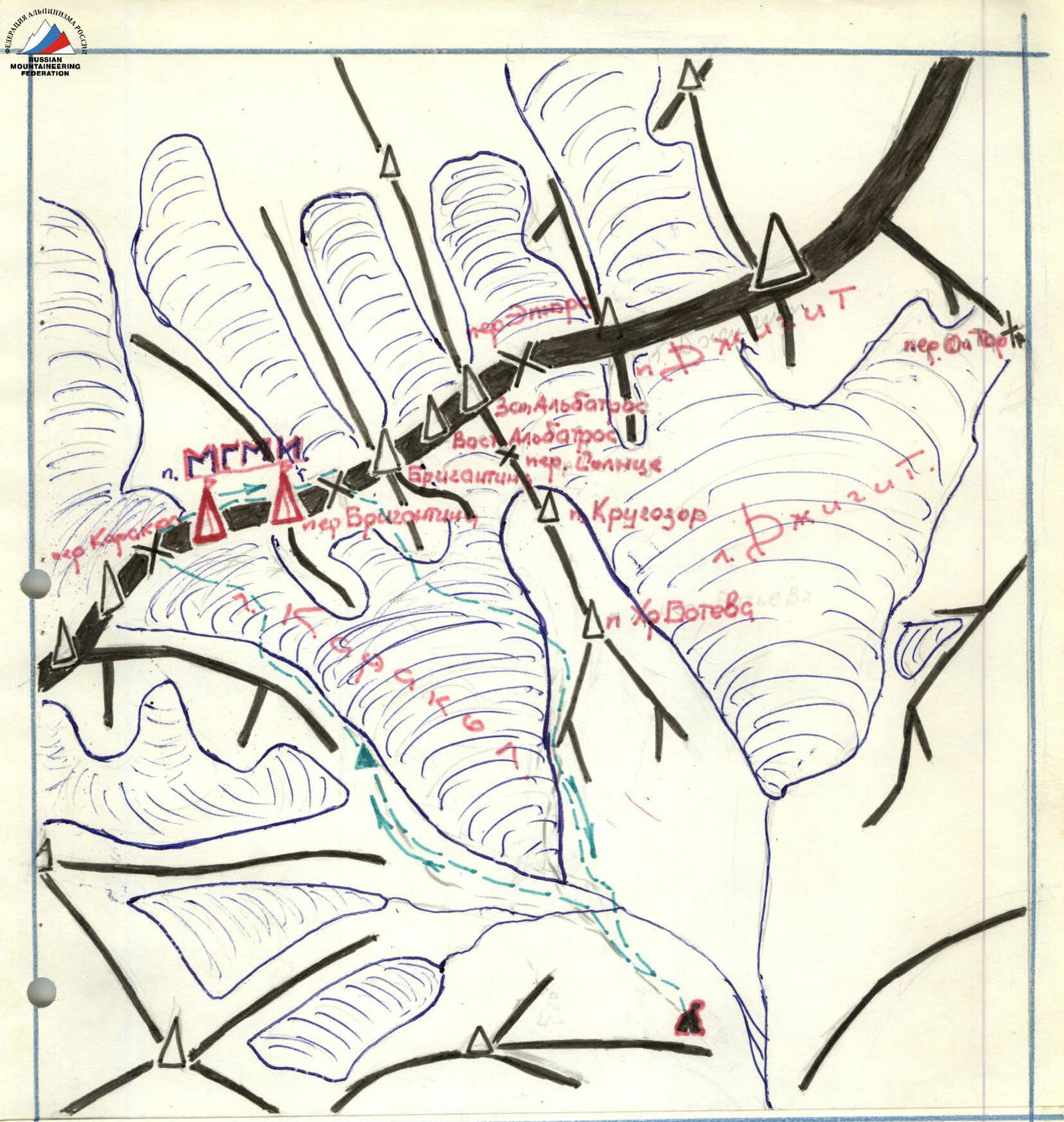
Karakol District
bivouac group's path base camp
Description of the Route Passage
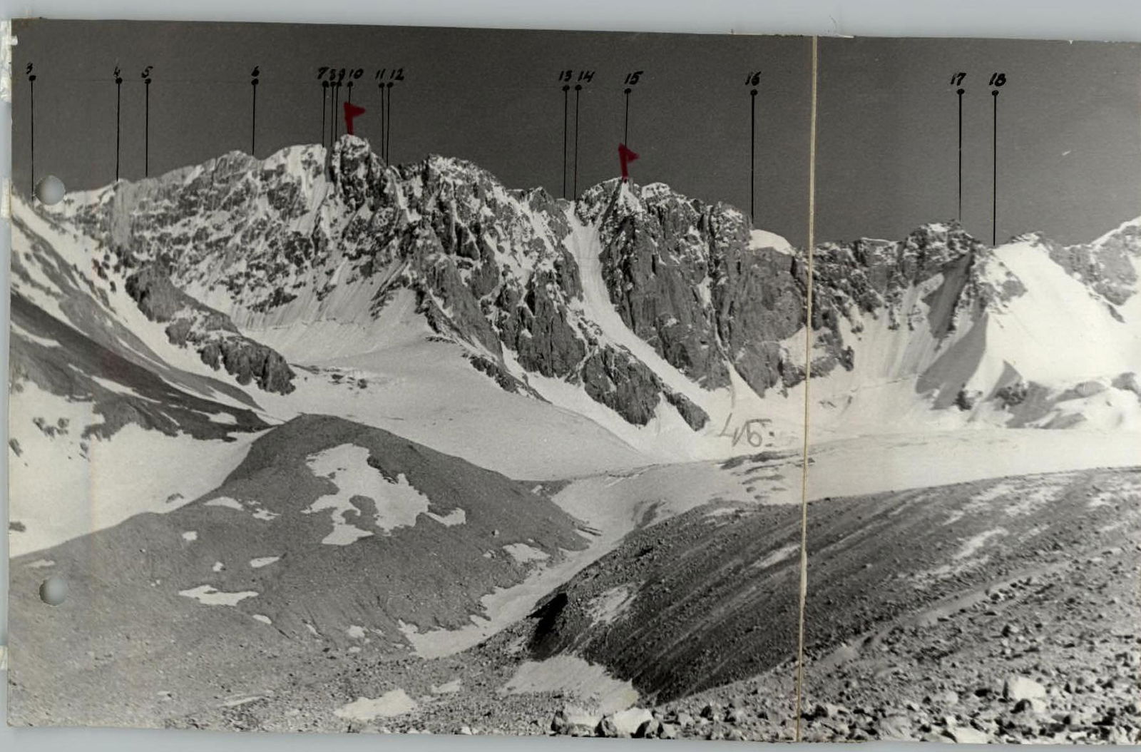
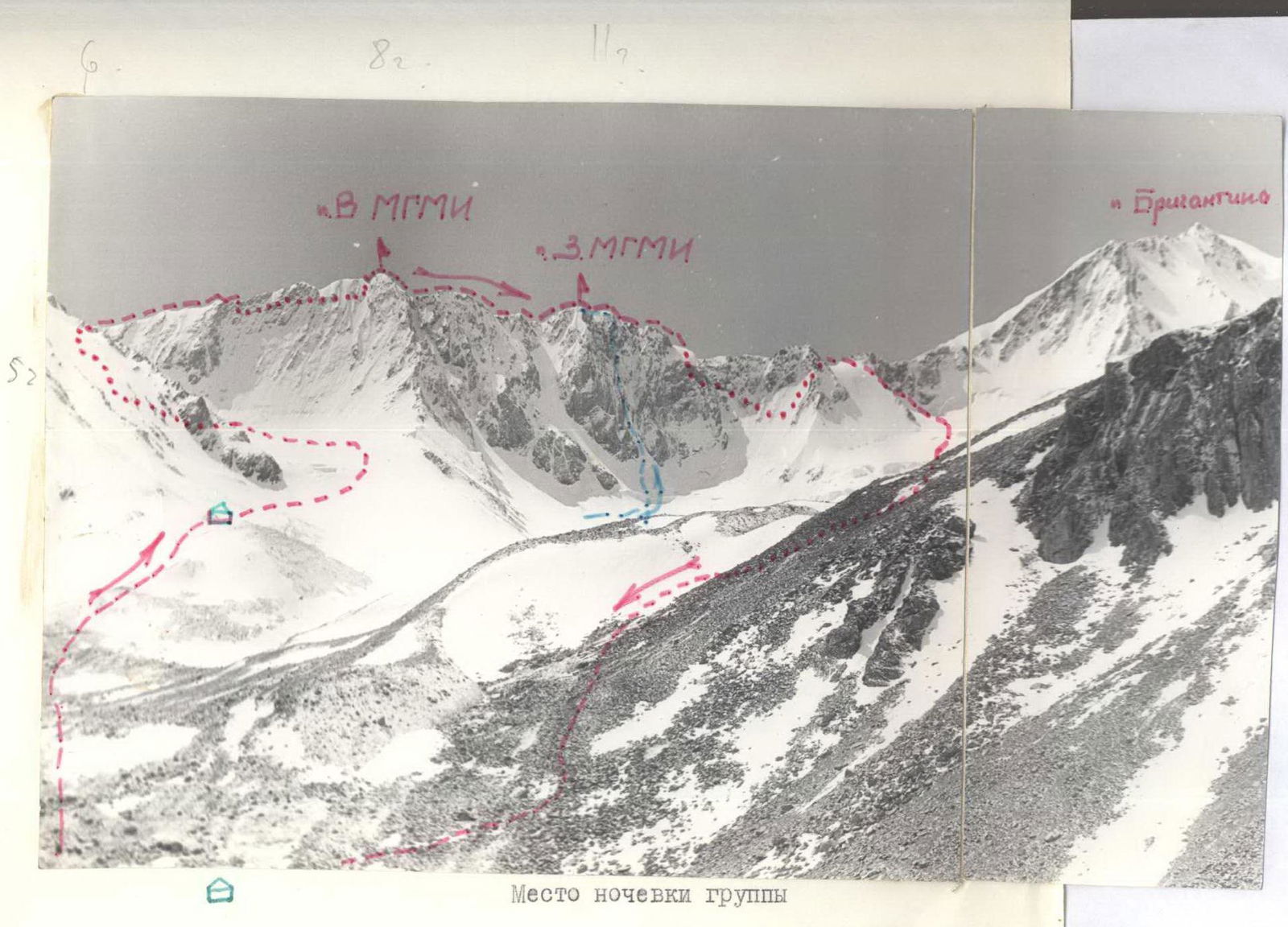
Our base camp was set up on a large green meadow at the foot of Peak Khristobotev. The peak divides the valley into two large cirques. In one of them, the majestic Jigit tower stands tall, and in the other, Brigantina is rightfully considered the queen. To the right of Brigantina, Peak Albatros spreads its snow-white wings, and to the left, a large massif with two distinct peaks stands as a wall. This is the MGMI massif.
It caught our attention from the first day of our stay in this area, and today we set out to lay our route to its peak.
July 12, 17:30. We left the base camp. The plan for today is to get as close as possible to the start of the route and conduct the necessary adjustments on the spot. By 19:00, we passed the last moraine and, finding a convenient spot for a bivouac, decided to stay here.
The Karakol pass is not visible, but the route is well observed from this location. This gave us the opportunity to:
- get more familiar with the ascent object,
- identify the most challenging sections of the route,
- consider different descent options,
- clarify potential bivouac locations on the ridge (in case of bad weather),
- note sections with overhanging cornices.
The reconnaissance conducted by the first rope showed that the pass, where our route begins, is within 1–1.5 hours' walk from the bivouac site, which suited us. Accordingly, we decided on an early rise, to traverse the glacier on firm snow crust, ascend to the pass, and then follow the ridge to the peak.
Concerns were raised by the unusually warm evening and numerous clouds gathering in the area of Lake Issyk-Kul — this is usually not a good sign.
With hopes for good weather and preoccupations about the upcoming climb, we had dinner and rested.
We woke up early, as planned, at 3:00. First, we peeked out of the tent to look at the sky. Hurray! Before us lay a beautiful Tian-Shan night:
- silence,
- complete calm,
- a slight frost,
- stars, large and bright, twinkling welcomingly, as if saying, "Enough sleep, it's time to start a new working day."
The mood was cheerful; within half an hour, we managed to have tea, get dressed, and all that was left was to pack the tent — and off we went. The frost was weak, and our plan to traverse the path to the pass on snow crust was not destined to be fulfilled. Our feet kept sinking, and we had to cut steps, which took a lot of energy.
Dawn caught us just below the pass. A little more — and we took the first barrier; the time was 5:00. And what beauty surrounded us…: The east was aglow, the peaks were tinted with a delicate pink hue, and the moon still lingered in the sky. All this set a lyrical tone, but we had to press on.
Directly from the pass, a snow-ice ridge stretches for about two rope lengths and abuts a small wall, 10–12 m, which is traversed by free climbing with piton protection; further on, the ridge is semi-destroyed, with many loose rocks. Within half an hour, we reached a jagged ridge-saw. The rocks were covered in ice, significantly complicating the passage of this 50 m section. Then, from the left side, we descended a bit and bypassed the first major gendarme, into which the saw ridge abutted. Climbing over slabs and ledges required great attention, utmost caution, and reliable protection. Many loose rocks, frozen snow, and snow-covered rocks.
The weather was delightful, work was easy, and spirits were high. The group was cohesive; we had undertaken not one ascent together in this composition; every gesture of a teammate was understood, the guys were attentive to each other, commands were clear, and there were no unnecessary words. The rope teams moved autonomously: sometimes simultaneously, sometimes alternately, with only rare instances of "rope team following rope team" movement (in places of heightened danger where additional protection was necessary).
We were making good progress, the sound of pitons being driven could be heard, and the first rope team was at work. The gendarme was behind us. To the south, a destroyed counterfort stretched from it. On its shoulder, we left a control cairn; the time was 7:00. We crossed a couloir, then made a steep ascent to the main ridge (monolithic walls). We decided to descend down the counterfort (sporting); then we crossed a second couloir (attention required) and reached the base of the second gendarme with an overhanging cornice. Ascending to the shoulder of the second gendarme, we came under an overhanging rock with a cornice. It was undesirable, of course, to encounter such a surprise mid-day when it was well warmed by the sun and ready to collapse. With necessary precautions, we bypassed the rock with the overhanging cornice on the left and then made a difficult, steep ascent to the main ridge (rocks with frozen snow, a thin layer of snow). We reached a snow saddle with a direct cornice by 8:00. Time to check in. Further on, there was an inner corner of a 10 m wall (piton protection) and a ridge leading to the Eastern MGMI peak. An attempt to find a cairn was unsuccessful."
We left our note, rested a bit. The weather was perfect; the landscape was visible far around. Even Prjevalsk city and Lake Issyk-Kul were visible. But time was passing, and we had to continue our journey. From the Eastern peak, we descended via the left side of the ridge (destroyed rocks), crossed a small 10-meter ice gully (careful protection required), with a steepness of 50°. We reached a saddle under a large rock blocking the ridge; we bypassed it on the left (protection). The further ridge presented rocks of medium complexity, with walls of 2–5 meters, many psychological challenges (snow cornices, loose rocks, destroyed rocks).
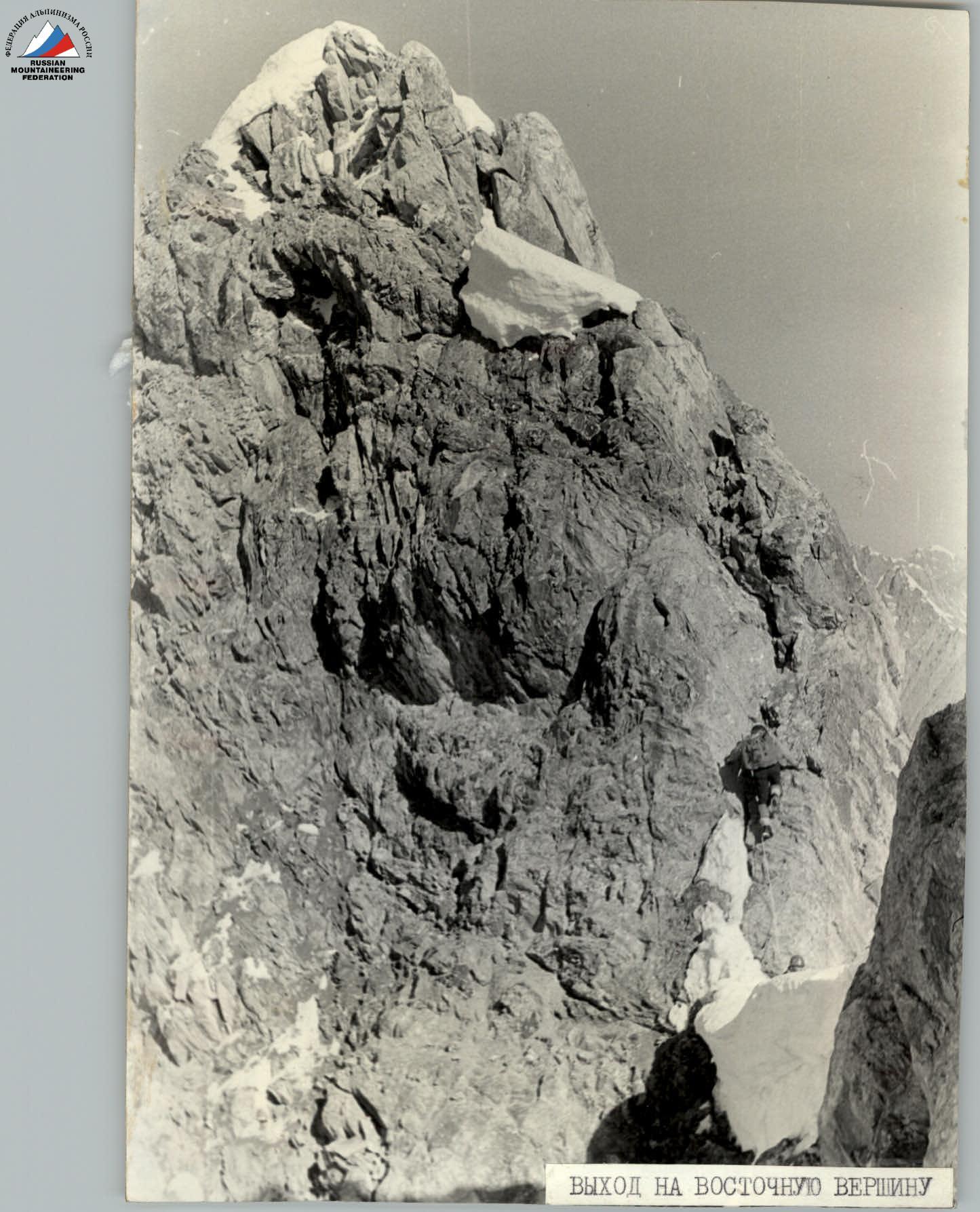 Ascent to the Eastern peak
Before reaching the Western peak, we traversed a snow-ice saddle and then made a steep ascent over slabs (75°) to the peak. The climb was tense, with reliable protection. We reached the peak at 12:00. During the break, we could warm up with tea, rest, look around, and discuss the further path; everything was going well, and the mood was cheerful. The peak offered a convenient platform for a tent; we could set up a decent overnight stay, just in case. We were lucky here: we found a note from August 13, 1973, left by a group of climbers from the "Ala-Too" alpine camp, who ascended to the Western peak via a category 4B route.
The descent to Brigantina pass initially followed the ridge to a gap; beyond the gap, we descended below the ridge to the southern side and moved along ledges in a traverse towards the pass. The ledges were quite steep, with frozen meltwater, snow, and loose rocks.
Utmost caution and reliable protection were necessary. For protection, we used:
- ledges,
- bends,
- reliable rocks.
In case of snowfall or bad weather, climbing these rocks would be very dangerous. It made sense to either descend directly along the ridge or make a sporting descent of a few rope lengths to the plateau to the south, and then ascend to Brigantina pass. All descent options lay only to the south. The descent from the peak to the pass took 3 hours.
On the pass, each of us knew that we would be back at the base camp in the evening; this gave us strength and prevented us from relaxing too early.
The descent to Brigantina glacier took 40 minutes; the path was familiar to us from previous ascents to Brigantina peak. Another half hour of walking through deep, heavy, wet snow — and we were on the moraine. We could unclip, hide the ropes, proudly look at the conquered massif, joyfully share impressions, congratulate each other, and recall difficult sections. But we had to hurry: we were being waited for, and people were worried about us.
The ascent was behind us, and it left an indelible mark in our memory. It was a success. This was facilitated by:
- the excellent weather that had held for several days,
- the clear work of the group,
- the excellent condition of the route,
- the good physical and technical preparation of the participants.
We were returning to camp, each lost in thought. Occasionally, someone would turn back and glance at the peak with a tinge of sadness, now left behind our backs. We reached the camp at the beginning of the sixth hour. The route was completed.
Table of Main Characteristics of the Ascent Route
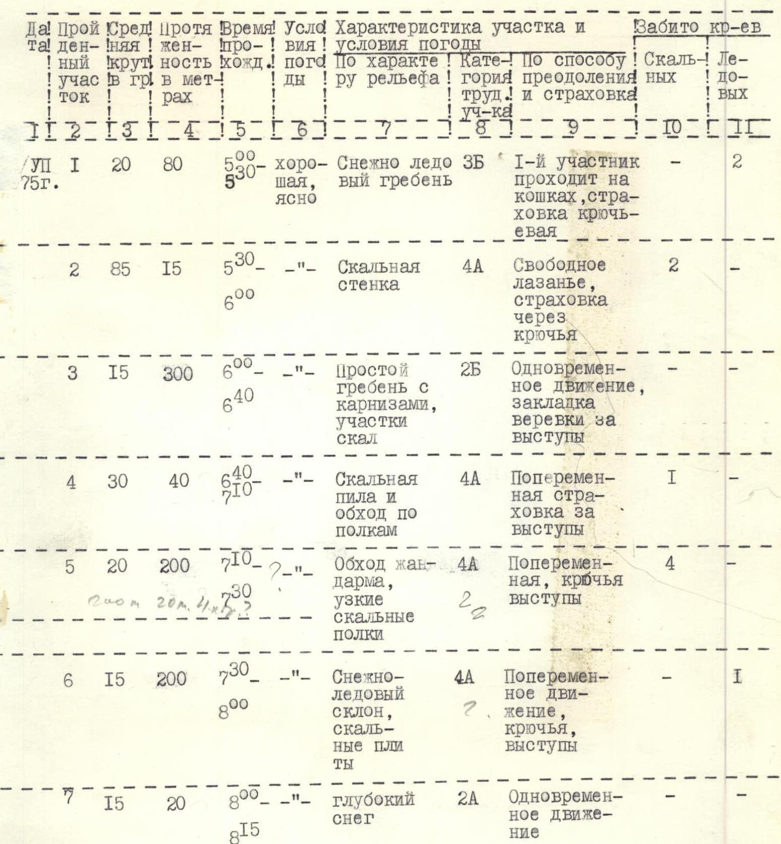
Ascent route: Peak MGMI — traverse of 2 peaks from Karakol pass. Route length: 2700 m. Height difference: 870 m.
| № | Traversed section | Steepness | Length, m | Time on section, min | Time of passage | Weather conditions | Characteristics of section and relief | Difficulty category | Method of overcoming and protection | Pitons driven: rock | Pitons driven: ice |
|---|---|---|---|---|---|---|---|---|---|---|---|
| 1 | Snow-ice ridge | 20° | 80 | 55 | 5:00 | Good, clear | Snow-ice ridge | 2Б | Proceeds on crampons, piton protection | 2 | — |
| 2 | Rock wall | 85° | 15 | 15 | 5:30 | — | Rock wall | 4А | Free climbing, protection through pitons | 2 | — |
| 3 | Simple ridge with cornices, rock sections | 15° | 300 | 15 | 6:00 | — | Simple ridge with cornices, rock sections | 2Б | Simultaneous movement, securing rope to ledges | — | — |
| 4 | Rock saw and bypass along ledges | 30° | 40 | 30 | 6:40 | — | Rock saw and bypass along ledges | 4А | Alternate protection using ledges | 1 | — |
| 5 | Bypass gendarme, narrow rock ledges | 20° | 200 | 20 | 7:10 | — | Bypass gendarme, narrow rock ledges | 4А | Alternate, pitons, ledges | 4 | 2 |
| 6 | Snow-ice slope, rock slabs | 15° | 200 | 15 | 7:30 | — | Snow-ice slope, rock slabs | 4А | Alternate movement, pitons, ledges | 1 | — |
| 7 | Deep snow | 15° | 20 | 8 | 8:00 | — | Deep snow | 2А | Simultaneous movement | — | — |
| 8 | Inner corner, destroyed rocks | 75° | 15 | 15 | 8:15 | — | Inner corner, destroyed rocks | 4А | Free climbing, piton protection | 2 | — |
| 9 | Piles of stones, snow sections, cornices | 40° | 50 | 20 | 8:30 | — | Piles of stones, snow sections, cornices | 2Б | Simultaneous movement | — | — |
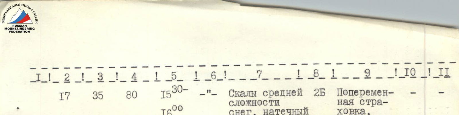
| 10 | Snow-rock simple ridge | 40° | 40 | 20 | 9:10 | — | Snow-rock simple ridge | 2Б | Simultaneous movement | — | — |
| 11 | Ice gully 50°, traverse | 25° | 10 | 20 | 9:20 | — | Ice gully 50°, traverse | 4Б | Alternate movement, piton protection | 2 | — |
| 12 | Rocks of medium complexity, snow sections, cornices | 35° | 800 | 20 | 9:40 | — | Rocks of medium complexity, snow sections, cornices | 4А | Simultaneous movement, protection through ledges | — | — |
| 13 | Snow-ice knife | 15° | 30 | 15 | 11:10 | — | Snow-ice knife | 4А | Alternate movement, protection through ledges | — | — |
| 14 | Snow-rock ridge, slabs | 60° | 80 | 15 | 11:40 | — | Snow-rock ridge, slabs | 3Б | Alternate protection using ledges | — | — |
| 15 | Rocks of medium complexity | 40° | 340 | 10 | 11:50 | — | Rocks of medium complexity | 4А | Easy alternate climbing, protection — ledges | — | — |
| 16 | Rock ledges, traverse | 85° | 400 | 30 | 12:50 | — | Rock ledges, traverse | 4А | Alternate protection, used perches, pitons, ledges | 3 | — |
| 17 | Rocks of medium complexity, snow, frozen meltwater | 35° | 80 | 15 | 16:00 | — | Rocks of medium complexity, snow, frozen meltwater | 2Б | Alternate protection, ledges | — | — |
| TOTAL | — | — | 2700 | — | — | — | — | — | — | 11 | 5 |
Total sections: 17.