Passport
-
Climbing category: technical.
-
Climbing area: Central Tien Shan, Terskey-Alatau ridge, Karakol valley.
-
Climbing object: Jigit peak, 5170 m, via the center of the North face.
-
Difficulty category: VI (I. Slesov's route).
-
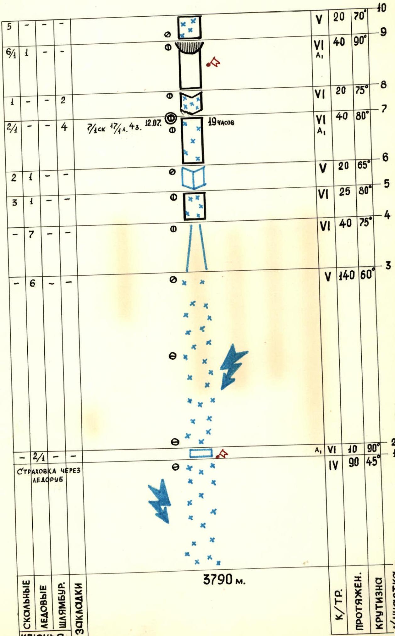
Elevation gain: 1380 m. Route length: 1695 m (including 250 m ridge). Length of sections with difficulty category 5-6: 1260 m. Average slope: 73° (3790–5115). Sections with difficulty category 6: 85° (3970–4420, 4630–4925).
-
Number of pitons:
| ice screws | rock pitons | chocks | bolt pitons |
|---|---|---|---|
| 26 | 131 | 9 | 0 |
| 1 | 6 | 0 | 0 |
-
Team's total climbing hours: 73 hours, 7 days.
-
Bivouacs: 1st, 2nd, 3rd — sitting, 4th, 5th — in a tent, 6th — in a tent on the ridge.
-
Team leader: RODIKOV ANATOLY PETROVICH — CMS (Candidate Master of Sports)
Team members:
- KUZOVOV YURY STEPANOVICH — CMS
- KORMUKHIN NIKOLAY POTAPOVICH — CMS
- SLAVKIN VIKTOR VASILYEVICH — CMS
- FIGUROVSKY NIKOLAY ALEKSEYEVICH — CMS
-
Team coach: SEMENYUK VALERY DANILOVICH — MS USSR (Master of Sports of the USSR)
-
Route start: July 12, 1983.
Summit: July 18, 1983. Return: July 19, 1983.
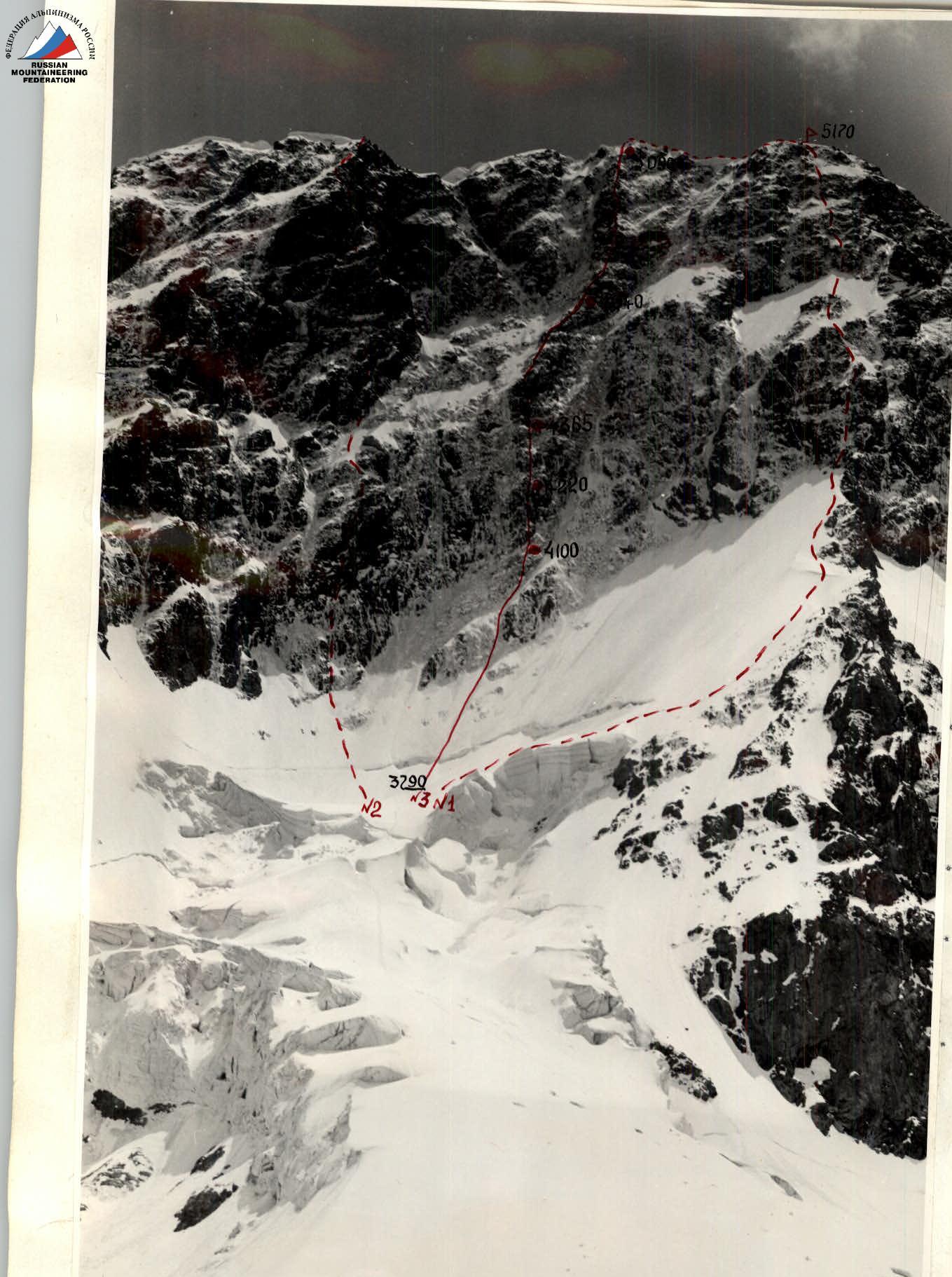
Photo #1. Picture taken from the moraine of the Jigit glacier, July 14, 1983, 9:00 AM, distance 2 km, lens "Helios-44".
- #1 — via the North face, 1965.
- #2 — via the triangle of the North face, 1976.
- #3 — via the center of the North face, 1975.
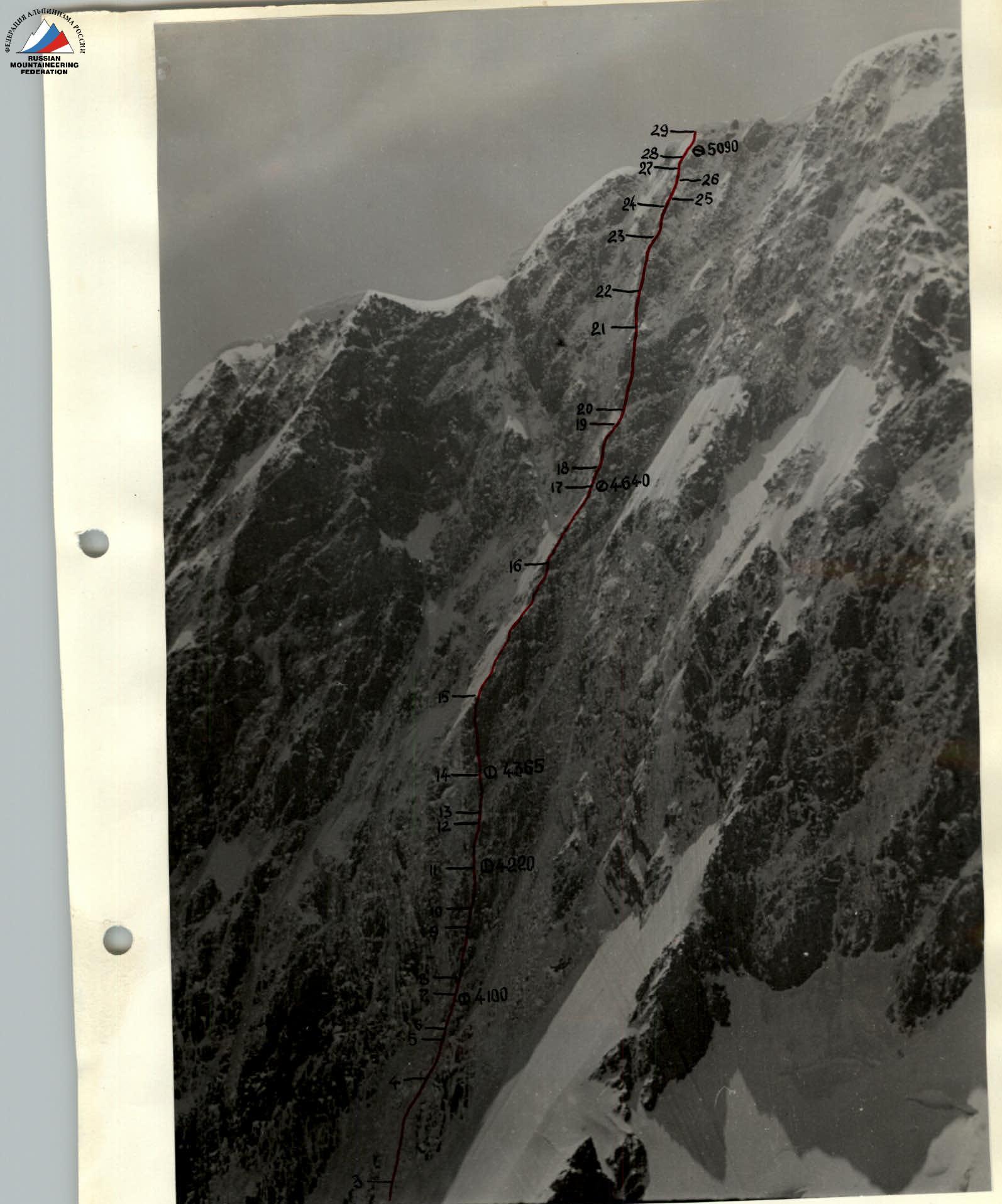
Photo #2. Profile of the wall on the right. Picture taken from the South slope of Delaunay peak, July 13, 1983, at 10:30 AM, distance 2.5–3 km. Lens "Helios-44".
Team's tactical actions
The tactical plan for the ascent was developed after prolonged visual observation of the route and a thorough study of the report on the first ascent made in 1976 by a team from the Rostov region. As a result, the tactical plan was fully implemented, taking into account the days allocated for bad weather. Due to the fact that the sections R0–R1, R1–R2, R2–R3, R3–R4 represent the most dangerous ("avalanche") part of the route, a night ascent was carried out. This ensured safe passage through the avalanche-prone sections and created a large reserve of daylight for work on the wall. Due to bad weather on July 16, the team processed the wall and abandoned the planned relocation of the bivouac.
Preliminary processing was carried out on sections R11–R12, R14–R15, R17–R18, R19–R20, R20–R21, R21–R22. Throughout the entire route, movement was carried out using ropes. The lead climbers were:
- A. Rodikov — R0–R1, R1–R2, R2–R3, R4–R5, R5–R6, R6–R7, R7–R8, R15–R16, R16–R17, R22–R23, R23–R24
- Yu. Kuzovov — R8–R9, R9–R10, R10–R11, R11–R12, R19–R20, R20–R21, R21–R22
- N. Figurovsky — R12–R13, R13–R14, R14–R15, R17–R18, R18–R19
- V. Slavkin — R24–R25, R25–R26, R26–R27, R27–R28
- N. Kormukhin — R28–R29, R29–R30, R30–R31
The change of lead climbers occurred on sections R7–R8, R11–R12, R14–R15, R16–R17, R18–R19, R21–R22, R23–R24, R27–R28.
On average, the team worked 12 hours a day, except for the first and fifth days. On the first day, to ensure safe passage through the avalanche-prone sections, an early start was made, and they worked almost until darkness fell, as it was necessary to reach the planned bivouac. There are no suitable places for organizing a bivouac below! On the fifth day, due to bad weather, the "twosome" processed the route, and the bivouac remained in the same place.
Throughout the entire route, there are no convenient places for bivouacs (Photo #1). The place where it is possible to organize a normal bivouac is on the summit ridge.
During the entire ascent, the observing group had the opportunity for constant visual observation of the team's actions, and regular radio communication was also maintained. The team's communication with observers was carried out using "Sony" radios, and observers communicated with the base camp using "Karat-M" radios.
3790 m
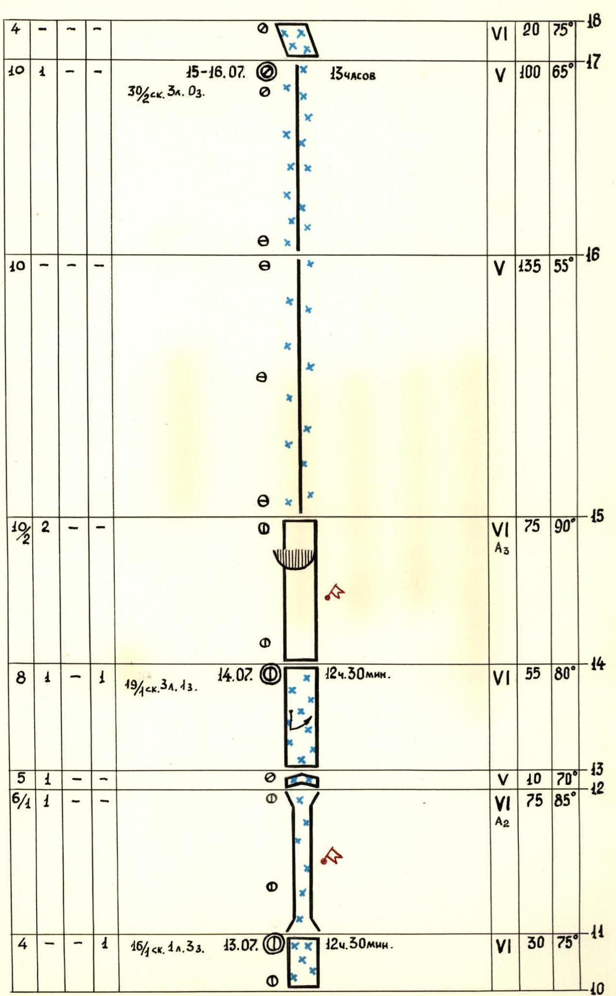
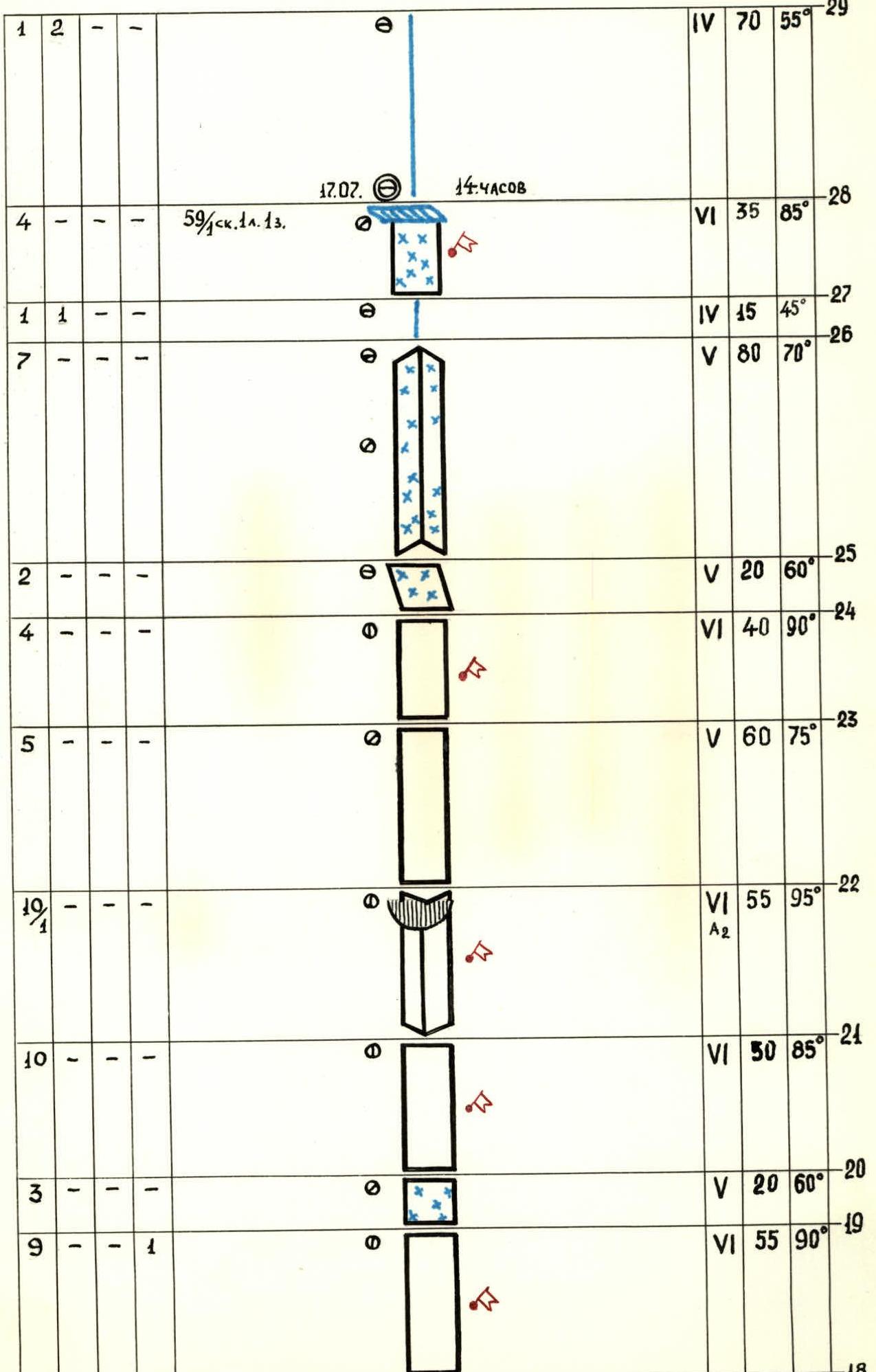
Total number of pitons: rock 131/6, ice 26/4, bolt 0, chocks 9. Belay via ice axe. July 18, 5170 m, 2 hours. 1 rock. 2 ice. 03.
Route description by sections
After passing the icefall — a snow cushion. From here, the routes via the center of the North face and via the triangle of the North face begin. From the "cushion" to the bergschrund, there is a snow slope with a slope of about 45°, which does not pose difficulties for movement (R0–R1), but is avalanche-prone, like the further path to the rocks. The bergschrund (R1–R2) is partially covered with thin snow bridges that collapse under the slightest load; the width of the gap is 3–3.5 m, the height difference between the lower and upper edges is from 5 to 10 m. It is passed using 12-tooth crampons and ice axes and ice screws; a three-step ladder was hung for the first person's passage. Behind the bergschrund, there is an ice slope (R2–R3) with a slope of 60°, three 50 m ropes. The slope has embedded rocks, and in the upper part of the section, there are rock slabs covered with a thick layer of ice, sufficient for organizing belay using ice screws. After the slabs, there is a steep ice gully-couloir (R3–R4) with traces of wet avalanches and rocks; after sunrise, it serves as a collector for snow and rocks falling from above. The gully must be passed as quickly as possible, on the right side, as early as possible. It is necessary to go 40 m to the narrowing of the gully, then to the right along the rock wall, covered with ice (R4–R5).
A very complex place: the slope is about 80°, ice screws are difficult to use due to the thin layer of ice. It is necessary to chip the ice to find a place for rock pitons. The wall turns into an ice-filled internal angle (R5–R6). It is better to pass on the right wall of the angle, closer to the rocks. The angle leads to a steep rock wall composed of blocks, covered with ice, with an abundance of "live" rocks (R6–R7). In the middle of the wall, there is a sheer section of 5–6 m, passed using a ladder. The wall ends with a vaguely expressed internal angle (R7–R8).
Then again, there is a wall (R8–R9): the upper part overhangs, but the rocks are clean — without snow and ice, with many cracks and holds. There are many places for reliable belay. The next section (R9–R10) is more gentle, but covered with ice, as is the next one (R10–R11). The further path goes through a chimney (R11–R12). The walls of the chimney are covered with a layer of ice, and water constantly flows. The chimney is steep and long — 70–80 m. It is also problematic to find places for driving pitons; it is necessary to chip the ice. The top of the chimney overhangs and turns into an external angle (R12–R13), composed of destroyed rocks. The climbing is complex: to organize belay, it is necessary to duplicate 3–4 pitons. Section R13–R14 is a rock, ice-covered wall, representing a combination of sheer, short walls, and narrow ledges. It is better to start moving along the wall on the left part. In the middle, it is necessary to swing to the right by 10–15 m using a pendulum, where the rocks are less icy. Then, there is a long, steep wall (R14–R15), free from ice, composed of monolithic blocks of enormous size. The wall ends with a rock cornice, for the passage of which two three-step ladders were used. Sections R15–R16, R16–R17 are a rock ridge, heavily snowed and ice-covered, not posing particular difficulties for movement. The ridge abuts against rock slabs (R17–R18), which are the foundation of the first tower. The slabs are divided by wide cracks; boxes are suitable for climbing. The tower (R18–R19) is a sheer wall, but due to the abundance of cracks and holds, the first person in the team (this section was passed by Yu. Kuzovov) passed it using free climbing. The top of the wall is ice-covered rocks (R19–R20), passed in crampons — this is the beginning of the second tower. The second tower (R20–R21) is similar to the first. The wall of the tower turns into an internal vertical angle (R21–R22) with a cornice. To pass, a ladder was used again. There are holes from bolt pitons, but almost everywhere, it is possible to use ordinary rock pitons. The section of the wall (R22–R23) above the cornice is much more gentle; there are many ledges on the rocks. Further, there is again a sheer wall (R23–R24) — this is the third tower, also passed using free climbing, like the two previous towers. The wall leads to slabs (R24–R25), turning into a giant external angle (R25–R26), the top of the angle is a snow ridge (R26–R27). The ridge abuts against a rock wall (R27–R28) with a snow cornice. Further, an ice-and-snow ridge with rock outcrops (R28–R29) leads to the summit snow ridge.