Climbing Passport
- Climbing category — technical
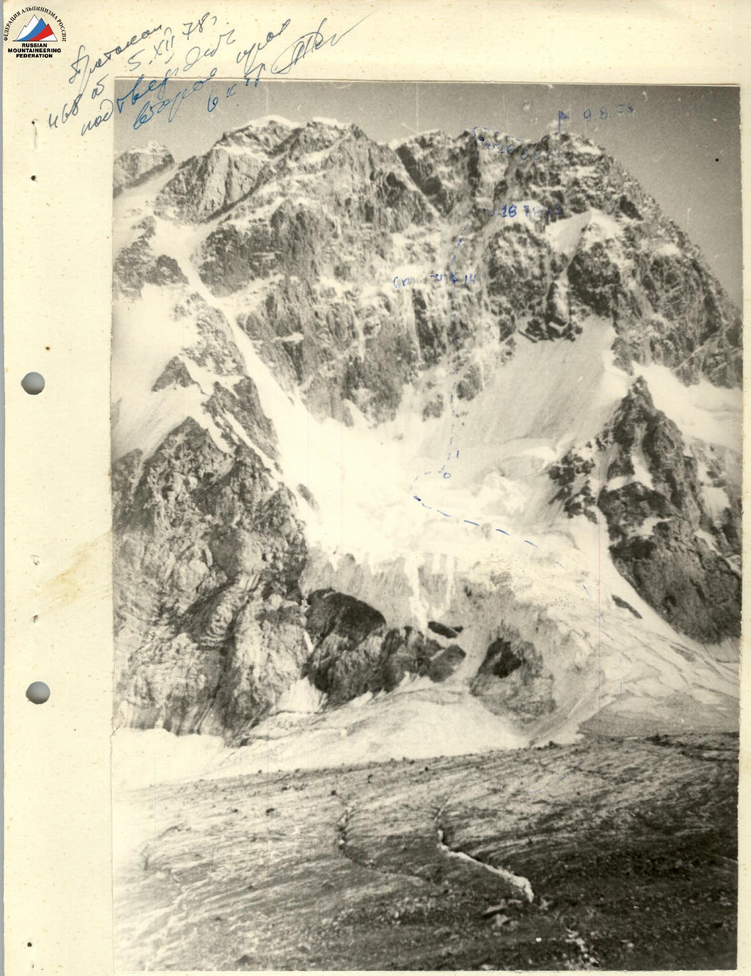
- Climbing area — Tian-Shan, Terskey Alatau
- Climbing route with summit height: second ascent via the center of the north face, Jigit Peak (5170 m)
- Proposed difficulty category 6B
- Climbing characteristics Elevation gain 1370 m (excluding serac icefall) Average slope 72° Length of sections 5–6 km, traverse 900 m
- Pitons used: rock 177, for artificial climbing aids 15, ice 27, bolted 0
- Total climbing hours: 32 hours
- Number of bivouacs and their characteristics: 3 bivouacs in hammocks.
- Surname, first name, patronymic of the leader, participants, and their qualification:
- Popov Valery Nikolaevich, Candidate Master of Sports
- Mikhailov Andrey Andreevich, Candidate Master of Sports
- Ponomarchuk Viktor Semenovich, Candidate Master of Sports
- Team coach: Koreneva Irina Efimovna
- Date of departure and return: August 6 – August 9, 1978
 Bivouac locations
Brief explanation of the table
After a heavily crevassed icefall — a snow-ice slope with a rocky outcrop at 65°, with a bergschrund in the middle section. Then an ice gully. Followed by rocks resembling "deer hooves," covered in ice. Slope 60°. Then a 50–60 m wall, covered in ice. Next, a 90 m section of an overhanging wall in a somewhat indistinct internal corner. The wall is filled with snow and ice. Beyond the wall are "deer hooves," followed by steep slabs. The slabs lead to an overhanging rust-colored wall that blocks the exit to a steep ridge. Then follows a 65° ridge with a series of small walls 250–300 m. The rocks are covered in ice. After the ridge are 4 pre-summit towers. The first tower has a relatively broken structure and good relief. Almost immediately, the wall of the 2nd tower rises with increasing steepness. At the top — a cornice. The wall of the third tower is vertical, with good relief. Then come slabs that transition into a steep wall. The rock wall of the fourth tower is filled with snow and ice. Beyond it, a snow-ice ascent with rocky outcrops.
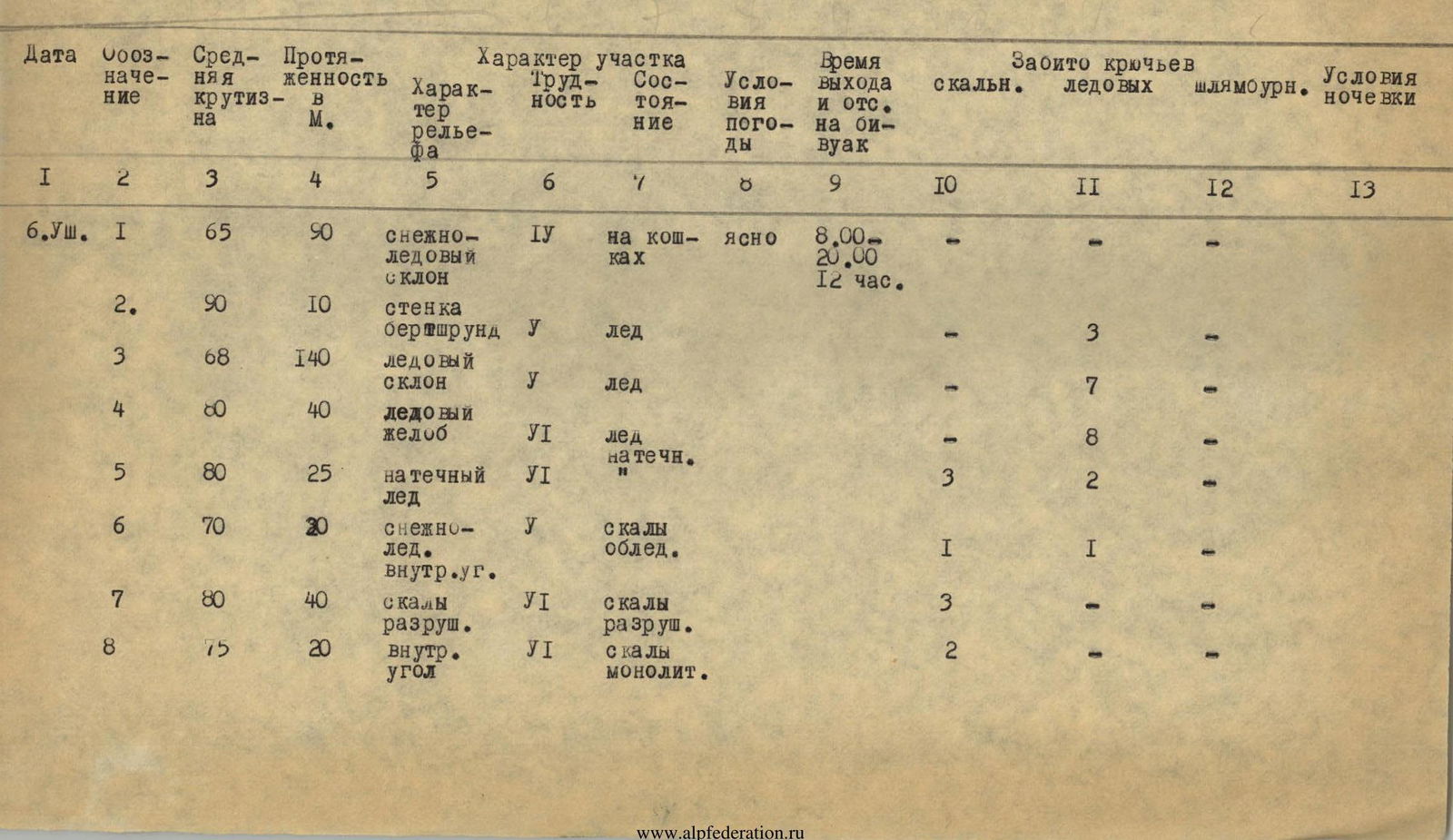
TABLE of main characteristics of the ascent route.
| Date | Section # | Average slope, ° | Length, m | Terrain characteristics | Difficulty | Condition | Weather | Time worked and rested, h | Rock pitons | Ice pitons | Bolted pitons | Bivouac conditions |
|---|---|---|---|---|---|---|---|---|---|---|---|---|
| 6.VIII | R1 | 65 | 90 | Snow-ice slope | 1 | Crampons | Clear | 8:00–20:00 (12 h) | – | – | – | |
| R2 | 90 | 10 | Bergschrund wall | 1 | Ice | – | 3 | – | ||||
| R3 | 68 | 140 | Ice slope | 1 | Ice | – | 7 | – | ||||
| R4 | 80 | 40 | Ice gully | 6 | Icicles | – | 8 | – | ||||
| R5 | 80 | 25 | Icicles | 6 | 3 | 2 | – | |||||
| R6 | 70 | 20 | Snow-ice internal corner | 1 | Icy | 1 | 1 | – | ||||
| R7 | 80 | 40 | Broken rocks | 6 | Broken | 3 | – | – | ||||
| R8 | 75 | 20 | Internal corner | 6 | Solid | 2 | – | – | ||||
| R9 | 95 | 40 | Wall with overhang | 6 | Solid | Clear | 10 | – | – | |||
| R10 | 75 | 20 | Rocks | 1 | 3 | – | – | |||||
| R11 | 80 | 30 | Rock wall | 6 | 7 | – | – | |||||
| R12 | 90 | 75 | Rock wall, icicles | 6 | Icy | 17 | – | – | ||||
| R13 | 70 | 10 | External corner | 1 | 3 | – | – | |||||
| R14 | 80 | 55 | Wall, icicles | 6 | Icy | 15 | – | – | In hammocks | |||
| 7.VIII | R15 | 95 | 75 | Rust-colored wall with overhang | 6 | 11:00–19:00 (8 h) | 23 | – | – | |||
| R16 | 60 | 135 | Steep snow-covered ridge | 1 | Snowy | 16 | – | – | ||||
| R17 | 70 | 100 | Steep ridge | 1 | Ice | 12 | 2 | – | ||||
| R18 | 75 | 20 | Slab | 6 | Solid | 4 | – | – | In hammocks | |||
| 8.VIII | R19 | 90 | 55 | Wall of 1st tower | 6 | Solid | 9:00–19:00 (10 h) | 11 | – | – | ||
| R20 | 65 | 20 | Upper wall of 1st tower | 1 | " | 3 | – | – | ||||
| R21 | 65 | 50 | Wall of 2nd tower | 6 | " | 8 | – | – | ||||
| R22 | 95 | 55 | Wall of 2nd tower | 6 | " | 15 | – | – | ||||
| R23 | 80 | 60 | Wall of 3rd tower | 1 | Solid | Clear | 9 | – | – | |||
| R24 | 90 | 40 | Upper wall of 3rd tower | 6 | " | 5 | – | – | ||||
| R25 | 65 | 20 | Slabs | 1 | " | 3 | – | – | ||||
| R26 | 75 | 0 | Wall with external corner formed by cracks | 1 | Snowy | 10 | – | – | In hammocks | |||
| 9.VIII | R27 | 50 | 15 | Snow col with cornice | 4 | Icy | 10:00–12:00 (2 h), summit | 1 | – | – | ||
| R28 | 65 | 35 | Rock wall with ice and snow above the tower | 1 | " | 7 | 1 | – | ||||
| R29 | 60 | 70 | Snow ascent with rocky outcrops | 1 | Icy | 1 | 3 | – | ||||
| R30 | – | 250 | Snow ridge with cornice | 4 | – | – | – |