PASSPORT
-
Technical class
-
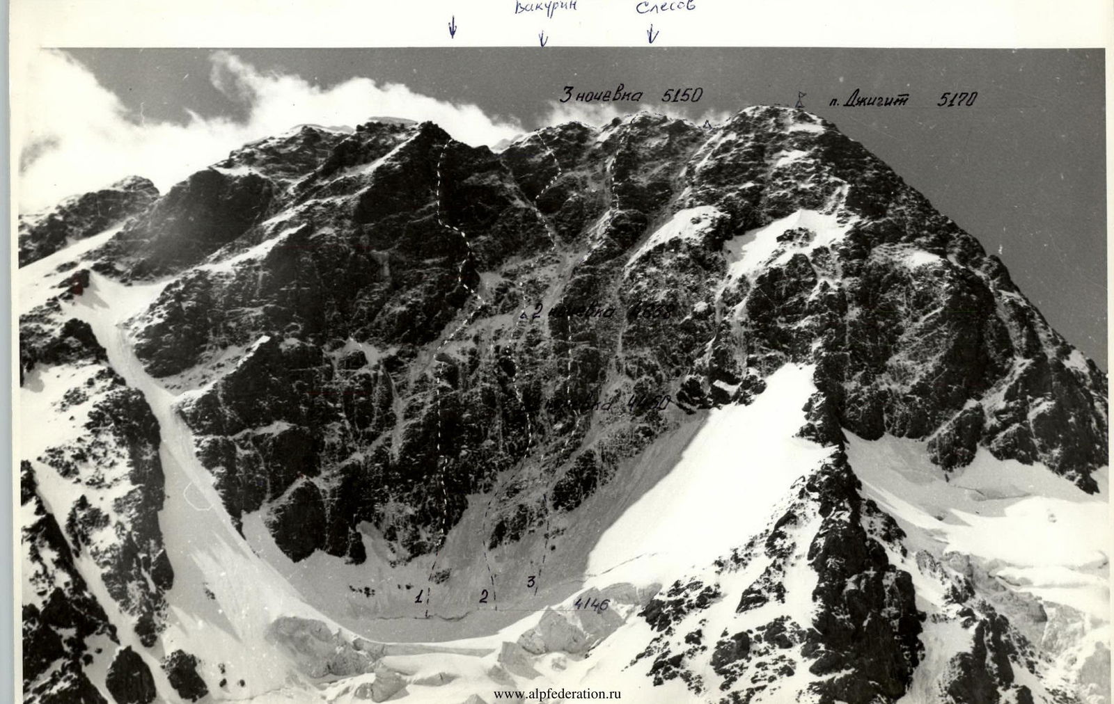
Kyrgyz Ala-Too
-
Peak Dzhigit, center of the north face
-
6th category of difficulty
-
Elevation gain: 1004 m, length 1165 m.
Length of sections 5–6 cat. diff. — 526 m. Average steepness of the route — 64° "lower bastion" — 76° "upper bastion" — 71°
-
Pitons driven:
| Rock | Bolt | Nuts | Ice |
|---|---|---|---|
| 110 | 0 | 67 | 43 |
| 14 | 0 | 7 | 0 |
-
Team's travel hours: 33 hours and days — 3
-
Overnights: 1st — sitting in pairs in hammocks 2nd — platform carved on a snow-ice slope, molded from snow and hammocks 3rd — platform carved in the summit ridge
-
Leader: VINOGRADSKY Evgeny Mikhailovich — Master of Sports of International Class
Participants:
- BRYKSIN Valery Mikhailovich — Master of Sports of International Class
- KIRZHAIKIN Anatoly Gerasimovich — Candidate for Master of Sports
- SHUKHMAN Sergey Vladimirovich — Candidate for Master of Sports
-
Coach: EFIMOV Sergey Borisovich — Honored Master of Sports
-
Exit to the route: July 8, 1985
Summit — July 11, 1985, return — July 11, 1985
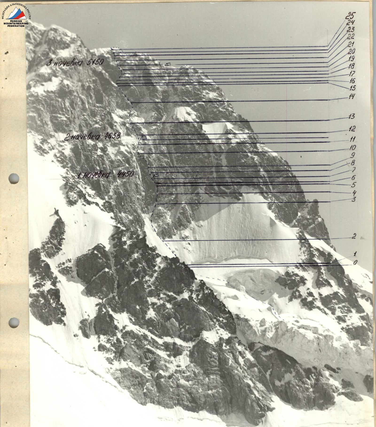
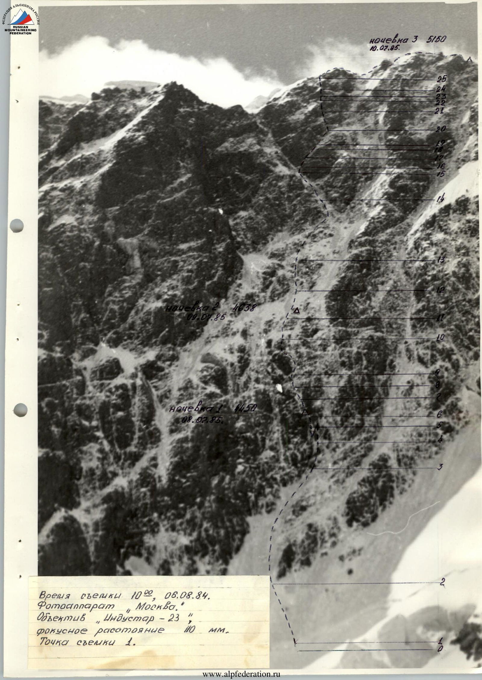
Route profile from the left
11.08.1984. 16:00 shooting point 2. Distance to object 4000 m. Height 3950. Camera "Moscow". Focal length 110 mm. Lens I-23.
In accordance with the tactical plan, the team left the base camp on July 6 and approached peak Dzhigit to the observers' camp on the left lateral moraine of the Dzhigit glacier. Around 20:00, a heavy snowfall began, which continued throughout the night and half of the next day, covering the wall with a continuous layer of snow (see photo 1). It was decided to postpone the exit to the route for a day. On July 8 at 4:00, the team left the observers' camp, although the wall was still shrouded in clouds, but the snow had stopped, and signs of improving weather appeared. The fallen snow made it difficult to advance. The approach to the bergschrund took 4.5 hours instead of the usual two. There was not much snow on the ice slope above the bergschrund (photo 2). The Kirzhaykin — Shukhman rope team worked ahead. By 12:00, they had passed 8 ropes of ice and approached the lower bastion (photo 3). Here, S. Shukhman went forward. Tense climbing in crampons on icy, snow-covered rocks was slowed down by the need to clear snow and ice from the rocks. Behind him remained a black trail of rocks cleared of snow, visible even from the observers' camp (photo 4). At 17:30, they reached an internal corner in the area of the planned bivouac according to the backup plan. They decided to spend the night here in hammocks, having previously processed the rope for tomorrow. The Bryksin — Vinogradsky rope team worked on processing. The overnight stay was sitting in pairs in hammocks under tarps. Snow was flowing down the wall all night.
On July 9, the Vinogradsky — Bryksin rope team worked ahead. The condition of the route improved somewhat. They passed the bastion and part of the ice slope in the wall's cauldron. They settled in for the night earlier to rest better. By stuffing two hammocks with snow and chopping off part of the ice, they organized an overnight stay under a rock island according to the tactical plan. The Shukhman — Kirzhaykin rope team processed the R12–R13 section from the evening. The weather was good all day.
July 10. The wall had cleared somewhat from snow over the previous day and night. Movement quickened. Shukhman was in front. In sections R15–R19, Kirzhaykin replaced him. He passed a very difficult section R15–R17. This is the second key point of the route, along with the lower bastion, but there is significantly less snow and ice here, so they climbed faster. At 14:00, they reached the planned location for the third overnight stay according to the backup plan and decided to continue moving and spend the night beyond the summit. S. Shukhman was the first to pass sections R19–R23. At 22:00, they reached the ridge. A snowfall began, visibility decreased, and a thunderstorm approached. Although the path was clear and known, they stopped moving and dug into the snow-ice ridge under a small gendarme, not reaching the summit. In the morning, after 10 minutes of movement, the summit was reached. The descent followed route 4A cat. diff. in strong winds and further deteriorating weather.
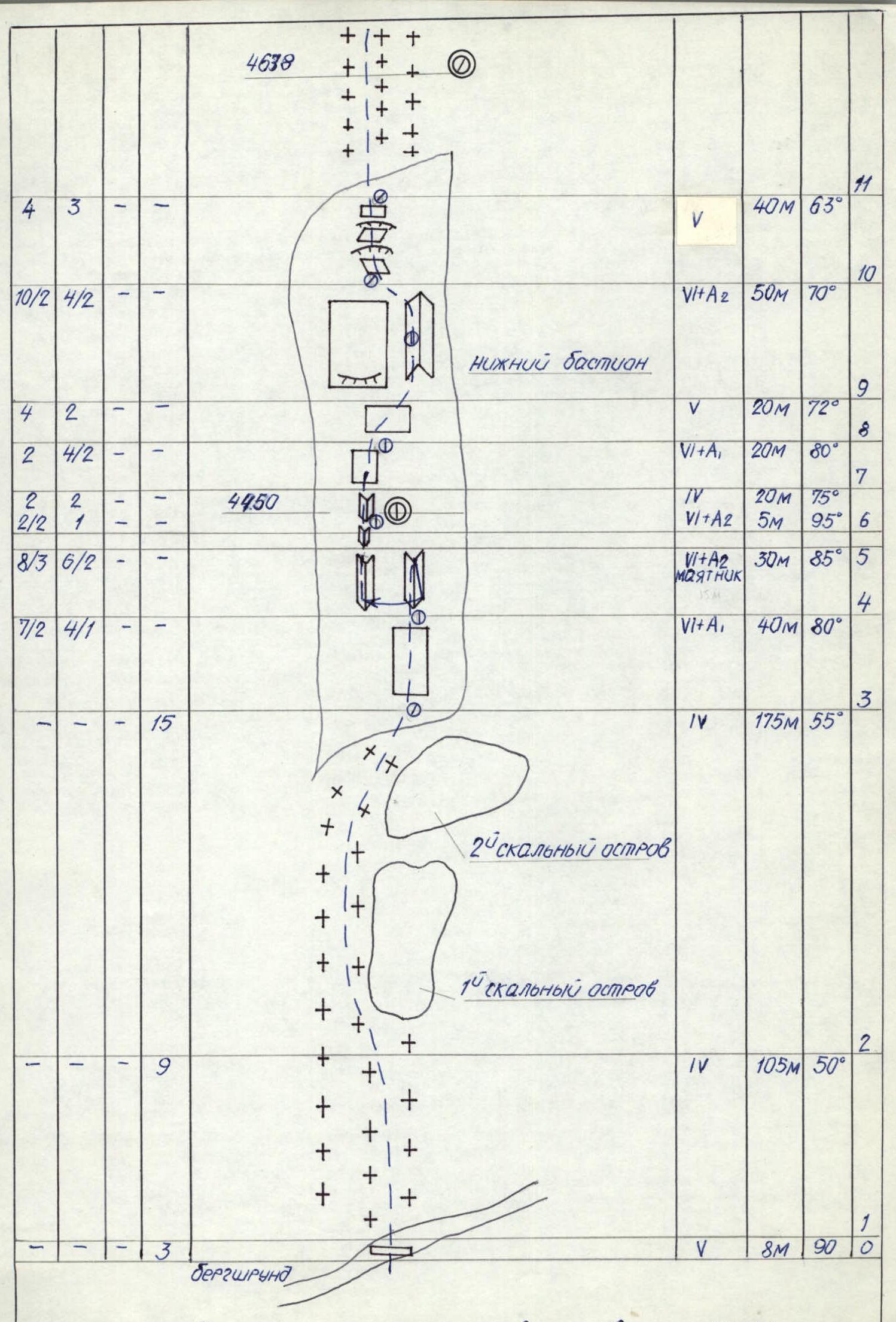
Route diagram in UIAA symbols
| Rock | Nuts | Bolt | Ice | Cat. | Length | Steepness | |
|---|---|---|---|---|---|---|---|
| 25 | 3 | 2 | — | 1 | III | 70 m | 40° |
| 24 | 4 | 2 | — | — | V+A1 | 24 m | 80° |
| 23 | 3 | — | — | — | V | 16 m | 90° |
| 22 | 3 | 3 | — | — | IV | 40 m | 80° |
| Upper bastion | |||||||
| 21 | 6/1 | 4 | — | — | V+A1 | 40 m | 75° |
| 20 | 0 | 2 | — | — | V | 30 m | 70° |
| 19 | 1 | 1 | — | — | IV | 15 m | 55° |
| 18 | 4 | 3 | — | — | V | 25 m | 75° |
| 17 | 5/2 | 3 | — | — | VI | 20 m | 80° |
| 16 | 2/1 | 1 | — | — | VI+A1 | 6 m | 85° |
| 15 | 10 | 8 | — | 3 | IV | 105 m | 60° |
| 14 | 15 | 6 | — | 2 | V | 110 m | 65° |
| 13 | 8 | 5 | — | — | V | 50 m | 75° |
| 12 | 2 | 1 | — | 10 | IV | 106 m | 55° |
| Lower bastion | |||||||
| 11 | 4 | 3 | — | — | V | 40 m | 63° |
| 10 | 10/2 | 4/2 | — | — | VI+A2 | 50 m | 70° |
| 9 | 4 | 2 | — | — | V | 20 m | 72° |
| 8 | 2 | 4/2 | — | — | VI+A1 | 20 m | 80° |
| 7 | 2 | 2 | — | — | IV | 20 m | 75° |
| 6 | 2/2 | 1 | — | — | VI+A2 | 5 m | 95° |
| 5 | 8/3 | 6/2 | — | — | VI+A2 (Pendulum 15 m) | 30 m | 85° |
| 4 | 7/2 | 4/1 | — | — | VI+A1 | 40 m | 80° |
| 3 | — | — | — | 15 | IV | 175 m | 55° |
| 2 | — | — | — | 9 | IV | 105 m | 50° |
| 1 | — | — | — | 3 | V | 8 m | 90° |
| 0 | — | — | — | Bergschrund |
Route description by sections
R0–R1 Bergschrund — a sheer ice wall 8 m high, with a snowy overhang at the top. Passed on the front teeth of crampons with two ice axes. Insurance through ice screws.
R1–R2 Ice slope with a steepness of 50°. Insurance through ice screws (two intermediate pitons per rope). Organization of belays.
R2–R3 Ice slope with an average steepness of 55°, with rock outcrops in the upper part.
R3–R11 Lower bastion. General characteristic — a steep, monolithic, sometimes overhanging wall, completely covered in ice and snow. Passed by climbing in crampons. To organize belay points, it is necessary to clear snow and ice from the rocks. Use of artificial aids, ladders, pendulum. There are no convenient places for belaying, resting, and bivouacking.
R3–R4 Monolithic wall with large relief. Application of artificial aids.
R4–R5 20 m along the inner corner, using artificial aids, very difficult climbing. Pendulum to the left 15 m into a wide inner corner (photo 5). Then in wedged positions. Good cracks for pitons.
R5–R6 Slightly overhanging smooth wall. Artificial aids.
R6–R7 Inner corner filled with snow. Monolithic wide cracks. At the beginning of the corner, an overnight stay in hammocks.
R7–R8 Wall with a series of small overhangs, movement under a black overhanging wall. Use of artificial aids. Sections R6–R7, R7–R8 processed on July 8.
R8–R9 Traverse to the right and up under the overhanging wall along the rock with small holds, with ice accretion. Careful climbing.
R9–R10 Very difficult inner corner. Rocks are smooth, there are no obvious holds, a lot of snow. Use of artificial aids.
R10–R11 Monolithic rock, in the upper part like "ram's foreheads". The overhang in the middle is bypassed on the left. Exit to the bend of the lower bastion.
R11–R12 Snow-ice slope with rock outcrops. Moving on ice. In the front part, under the cover of a rock island, an overnight stay on a platform constructed with the help of snow-filled hammocks.
R12–R13 Implicitly expressed inner corner, smooth rocks, a lot of snow. There are no obvious holds. The section was processed on July 9.
R13–R14 Gentle dissected rocks with large relief, covered with dry snow. Movement towards the beginning of the upper bastion.
R14–R15 Giant inner corner, limiting the upper bastion on the left. In the upper part, it is closed by overhangs, covered in ice. Movement along the left side of the corner on the front teeth of crampons. There are rock outcrops.
R15–R16 Vertical rock wall passed with the use of artificial aids, the rock is fragile.
R16–R17 Extremely difficult diagonal traverse along a narrow inclined ledge, on which there are many loose rocks and snow. The wall above the ledge overhangs; to avoid being thrown off, artificial aids are used.
R17–R18 Rock wall with diverse relief. Rocks are loose. There are few reliable places for belay points.
R18–R19 Rocks of medium difficulty, with good holds, wide cracks.
R22–R23 Vertical chimney with large holds, ice accretion. Passed by climbing.
R23–R24 Clean monolithic rocks. Difficult climbing with the use of artificial aids.