Report
On the Traverse of Brigantina and Albatros Peaks, Carried Out by the Chelyabinsk Region Team from August 3 to 7 for the CS SDSO "Burevestnik" Championship
The peaks of Brigantina (4850 m) and Albatros (Eastern – 4800 m, Western – 4740 m) are located in the axial part of the Terskey-Alatoo ridge (see orographic scheme) and close the Kokbor valley (55 km south of the city of Przhevalsk). The Kokbor River is a right tributary of the Karakol River (the peaks are located in the upper reaches of the right tributary of the Kokbor River). A truck can reach 19 km up the Karakol valley, and then a good horse trail continues for another 21 km, followed by 15 km of shepherd trails to the tongue of the Brigantina glacier. Loads are transported up from the end of the motor road by shuttling.
The peaks of Brigantina and Albatros, like all the surrounding peaks, are composed of granites, which are enriched with feldspars in many places.
The northern slopes of Brigantina peak are an ice wall cut by two steep ridges-counterforts: the northern and northwestern ones, leading to the eastern ridge. The slopes of Albatros drop steeply to the north with ice walls having sheer cliffs in the upper part.
From the Brigantina peak to the saddle, there is a snowy corniche ridge. The ridge leading to the Eastern and further to the Western peak of Albatros is a rocky saw (26 gendarmes) with numerous cornices hanging on both sides.
No attempts to ascend these peaks have been made so far due to the low popularity of the area. We got acquainted with this area in 1954. As a result of reconnaissance carried out in 1957, 1959, and 1962, routes for ascents to the peaks were identified. The northwestern ridge of Brigantina and Albatros peaks attracted particular attention, representing the greatest sporting interest. The sharp, steep ridge drops 360 meters to the glacier. The height difference on the ridge is 1250 m (3600–4850 m). The length of the traverse from the Brigantina peak to Albatros (West) is 3 km. The route is combined. Pure and ice-covered rocks alternate on the ridge with snowy and icy sections of significant steepness, and on the traverse, there are numerous small and large cornices. The peaks are located at 42° north latitude, and the northwestern ridge of Brigantina is lit in the evening (the wall is lit only at sunset).
The Terskey-Alatoo ridge stretches almost in the latitudinal direction and stands as a mighty barrier to the southwestern winds, directing them to the Khan-Tengri-Pobeda region. Naturally, partial condensation of vapors occurs in its highest part, i.e., in the area of Dzhigit peak. In this area, moisture evaporating from the vast surface of Lake Issyk-Kul also condenses, i.e., coming from the north. Precipitation often has a pronounced periodic character: daily (with rare exceptions) from 12:00 to 14:00 and from 18:00 to 20:00. Prolonged bad weather (3–4 or more days) often coincides with the change in the moon phase. Overall, the meteorological conditions in the area are harsh.
The entire route is visible from the Brigantina glacier. The creation and preparation of a team capable of confidently tackling such routes began in 1957. These long years were spent forming and training teams capable of confidently completing the challenging route, developing, researching, and testing various special mountaineering equipment. The gatherings in Bezengi, held in 1961, 1963, and 1964, played a significant role in team formation.
Since 1960, the group has been using non-standard mountaineering equipment manufactured in-house:
- Ice screws made at alloys D16AT and V-95 with a conical thread on the body, a steel head (on the thread with a cotter pin), and titanium eyes.
- Universal rock screws of various thicknesses and sizes made from titanium alloys and D16AT.
- Carabiners of the standard type made from V-95 alloy.
- Rappel nylon carabiners (6 mm diameter rope).
- Reusable piton hangers with cunning hanger fastening; 12 mm diameter (body – titanium, wedge – steel, eye – titanium).
Annual equipment tests are conducted in the research laboratory of the Strength of Materials Department at Chelyabinsk Polytechnic Institute under the guidance of the Chairman of the Strength Committee of NTO Mashprom, Associate Professor D.A. Gokhfeld.
Many members of the alpsection at ChPI, who are research scientists, participate in equipment manufacturing and research.
The specified equipment was tested by participants on 14 routes of 5th category difficulty. As a result, changes were made to the samples. For example, the cylindrical sleeve of the carabiners was replaced with a hexagonal one, allowing work with carabiners without removing gloves, which is crucial on "cold" routes. The thread pitch of the ice screws was changed, improving their removal from ice, etc.
To better prepare for the route, regular training on snowy and icy rocks and running on deep snow were introduced in the winter period.
Organizational Plan
-
The assault group consisting of:
- A. Ryabukhin
- V. Samokhvalov
- O. Trubnikova
- V. Makovetsky
- I. Levchenko
- V. Osipov
The support group consisting of:
- V. Mokshantsev (quartermaster of the gathering)
- V. Smirnov
- V. Utrivanov
- V. Tsekunov
will conduct training gatherings at the Talgar alpine camp from July 10 to 29.
-
On July 10, a group consisting of Yu. Smirnov, V. Denisov, P. Greilikh, V. Grafov, L. Mokshantseva, G. Rung (gathering doctor), V. Khudozhin, G. Sidorov, led by B. Revnikov (a participant and, in recent years, the leader of expeditions to this area in 1954, 1957, 1959, 1963, and 1964) will travel to the Karakol valley, conduct reconnaissance, set up the "Green" camp (2800 m, at the confluence of the Oktyabr and Kokbor rivers, in the forest), and obtain horses for the caravan.
-
July 31 – August 1: All participants gather at the end of the motor road (Ratska's parking).
-
August 1–2: The assault group, accompanied by 8 support members, will head to the Brigantina glacier to observe the route. The rest of the participants will, under the leadership of V. Mokshantsev, transport loads to the "Green" camp.
-
August 3–4: The assault group starts on the route. All other participants ascend to the Brigantina glacier to the Observers' camp.
-
After the assault group's return from the traverse, everyone gathers to rest in the "Green" camp.
-
Gathering participants will carry out sports ascents according to the plan developed by the training council.
-
August 20–22: Transportation of loads to the beginning of the motor road (Ratska's parking) and further by car to Alma-Ata.
This plan was fully executed. For training and acclimatization ascents, the assault group chose Pik Ai-Tau (4720 m), category 1B, and G. Talgar (5017 m) via the western ridge, category 3B.
The ascent to G. Talgar took place in poor weather conditions, which once again tested the group's readiness to work on the route in challenging meteorological conditions, typical for the upper reaches of the Karakol valley.
The gathering doctor, also a graduate of the alpsection at ChPI, second-class athlete, surgeon G.R. Rung (doctor at the Chelyabinsk City Physical Education Dispensary), conducted constant systematic observation of the participants, both in the mountains and in the city, adjusting loads during training and the nature of training. This allowed participants to accomplish a significant amount of work without strain or fatigue.
After plotting the route this year, the tactical plan for the ascent and traverse was finalized:
-
a) The exit to the ridge will be made via the couloir on the right side of the wall and then along the wall; the entrance to the couloir is under the ice falls, so the group must enter the couloir before 6:00 (when the sun starts illuminating the falls).
-
b) The first night will be spent under the "red" gendarme in muldas or, if possible, immediately behind this gendarme on a snowy shoulder; the second night – on the western ridge of Brigantina in a mulda or on the saddle between Brigantina and Albatros (East); the third – on the ridge between the Albatros peaks in the area of a large snowy cap with cornices to the north; the fourth – on the saddle between Pik Albatros (West) and Dzhigit or on the Dzhigit glacier.
-
c) When traversing the corniche ridge, frequently alternate between rope teams due to the likely significant psychological load.
-
d) In case of prolonged bad weather with no visibility on the corniche ridge, descend from the ridge to the south into the Kuiyu valley and return to the camp via the Karakol pass.
-
e) Take the following equipment on the route: ropes 2×40 m, 1×60 m, ladders 2×1.5 m.
The route differs from the one outlined in the application as follows:
-
The exit to the northwest ridge of Brigantina is made via the couloir on the right side of the wall with an exit to the western face of the wall in its middle part, rather than directly up the wall. This ensures the group the greatest safety: the western face, unlike the northwestern one, is more stable (there are no rockfalls here).
-
The descent from Albatros (West) is made along the simpler southwestern ridge rather than the northwestern one.
On August 3 at 4:00, the group left the "Observers'" camp, located at the left edge of the Brigantina glacier near a large stone (3540 m), towards the avalanche cone to the right of the base of the northwestern ridge wall. Within 40 minutes, they crossed the glacier (1.5 km). The glacier is closed, broken by numerous transverse crevasses. The starting point of the route is at an altitude of 3600 m.
Up the firm avalanche cone, crossing a snow-filled marginal crevasse, they ascended to the mouth of the couloir on the right side of the wall (sect. 1, fig. 5). Up the icy couloir, they rose to a characteristic niche-shelf on the western face of the wall (sect. 2). For the first half of the path, with a slope of 55°, the first rope team, Makovetsky – Osipov, led the way; on the second half, when the slope increased to 60°, they were replaced by the rope team Samokhvalov – Ryabukhin.
30 m above the niche, a rightward-upward ice groove (sect. 4) was reached via cleaved slabs filled with accretion ice in the upper part (sect. 3). From the top of the groove, they went straight up the slabs, cleaved in the upper part and turning into highly cleaved steep rocks upon reaching the top of the wall (sect. 5). At the top of the wall, there were many platforms and shelves convenient for rest.
The wall turned into a broad ridge, with the lower part (90 m) having a slope of 60° and the upper part (80 m) – 70° (sect. 6, fig. 4). The first rope team, Makovetsky – Osipov, led the way. The ridge gradually narrowed and then flattened out, turning into a snowy and icy ridge with three small gendarmes (sect. 7, fig. 4, 7). At the end of this ridge, before the large "red" gendarme, there were two muldas with cornices to the east – a convenient place for a night's stay. The group set up a bivouac here.
August 4. The "red" gendarme (sect. 8) overhung the ridge, so they immediately moved to its left face (fig. 8). The character of the rocks forming the gendarme was diverse, but mostly they were slabs, either smooth or rough. Straight up for 30 m on 80° slabs, and then they moved 10 m left on barely visible ledges and further left-upward, bypassing smooth steep slabs with "live" stones (fig. 9). The bypass continued to an ice groove (with a slope of 70°) descending from the ridge behind the gendarme. Along the edge of ice and rocks, they reached a small, almost horizontal ridge behind the gendarme. Here, a control cairn was built. This section was led by the rope team Samokhvalov – Ryabukhin.
Further on, highly cleaved rocks (with many "live" stones) alternated with snowy and icy ridges (sect. 9). The next snowy and icy section (sect. 10) was led by the rope team Makovetsky – Osipov (fig. 10). A small rocky section of moderate difficulty (sect. 11) led to the corniche eastern ridge (fig. 11). On the way to the peak, there were three rocky gendarmes (sect. 12, fig. 12). A steep corniche ridge led to the peak (sect. 13, fig. 11). A cairn was built at the exit of rocks north of the large summit corniche.
They traversed the summit cornices to the right (sect. 14, fig. 12) and then descended straight down (sect. 15) into an ice mulda, exceptionally convenient for a night's stay.
August 5. They exited onto the western ridge of Brigantina peak, traversing the slope below a crevasse leading to the second mulda. They moved along the ridge (fig. 13), hacked through a large corniche overhanging rocks at the saddle, traversed under it on a steep icy slope, and reached rocks (fig. 14).
Snowy cornices on the saddle (sect. 17, fig. 15, 16, 16a) were traversed from the left. A 300-meter rocky saw led to the Albatros (East) peak (sect. 18), with snowy and icy cornices hanging between its "fingers" (fig. 19). A control cairn was built on a rocky gendarme with a characteristic corniche (fig. 18). Along with monolithic rocks, the ridge had many cleaved sections consisting of separate blocks of various sizes and steepness. Such sections had an abundance of "live" stones (fig. 20). Three gendarmes above the control cairn were bypassed from the left. The rest were tackled head-on. They reached the peak at 13:00. A cairn on the Albatros (East) peak was built on a large rock dropping steeply on three sides (fig. 21). The ridge from the saddle to the peak was traversed by rope teams frequently changing leads.
A 400-meter highly destroyed ("live") corniche ridge led to the saddle between the Albatros peaks. Rocks descended in steps, with many "live" stones on the ledges, making it difficult for the group to move (sect. 19, fig. 22, 23).
On the saddle, before a large snowy cap, they set up a night's bivouac on a snowy ridge.
August 6. A 400-meter ridge with many rocks and cornices led to the Albatros (West) peak with a slight gain in height (sect. 20). The cornices were overhanging: part of the corniche hung to the south, while the other part hung to the north (fig. 24, 25). The rocks in this part of the ridge were monolithic "fingers" 2–10 m high (fig. 24). Some cornices (hanging to the south) overhung significantly (curling under themselves), making it difficult to determine their line of break-off. Most such cornices were bypassed from the south on ice and rocks (fig. 26). The group reached the Albatros (West) peak at 16:00. The descent along the southwestern ridge to the saddle between Pik Albatros (West) and Dzhigit presented no technical difficulties – gentle, highly weathered rocks with snowy sections (sect. 21, fig. 27). The plateau on the saddle was very convenient for a night's stay (fig. 28).
August 7. The descent from the saddle to the north onto the Dzhigit glacier: first, a 50–60° icy slope (sect. 22). Four ice screws were left on it for organizing the descent. Below the marginal crevasse, the slope flattened to 30° (sect. 23) and turned into the body of the eastern branch of the Dzhigit glacier.
Table of Key Characteristics
Route: traverse of Pik Brigantina – Albatros (East) – Albatros (West) Height difference on the northwest ridge of Brigantina – 1250 m Including the most challenging sections: see notes Average steepness of the northwest ridge of Brigantina – 54° Including the most challenging sections on the ridge: rock – 80° (150 m), slabs – 65° (30 m), ice – 60° (90 m).
| Date | Section | Average Steepness | Height Length | Terrain Character | Technical Difficulty | Method of Overcoming and Belaying | Weather Conditions | Exit from Bivouac | Time of Stop on Bivouac | Hiking Hours | Driven Pitons (Rock) | Driven Pitons (Ice) | Bivouac Conditions | All Days Ration |
|---|---|---|---|---|---|---|---|---|---|---|---|---|---|---|
| 3.08 | 1 | 45 | 170 | firm snow | easy | crampons, ice axe | norm.: cloudy, wind | 4:00 | 12 | 2 | 5 | |||
| 2 | 58 | 130 | ice | difficult | crampons, pitons, step cutting | —" | 2 | 5 | ||||||
| 3 | 65 | 30 | slabs | difficult | free climbing, pitons, ledges | —" | 2 | — | ||||||
| 4 | 60 | 30 | ice groove | difficult | free climbing, pitons, step cutting | —" | 4 | — | ||||||
| 5 | 80 | 70 | rocks | difficult | free climbing, pitons, ledges | —" | 6 | — | ||||||
| 6 | 65 | 170 | rocks | medium difficulty | free climbing, pitons, ledges | —" | 9 | — | ||||||
| 7 | 50 | 135 | rocks, snow | medium difficulty | free climbing, pitons, ledges | —" | 19:00 | 15:00 | — | — | good, tent 1000 | |||
| 4.08 | 8 | 80 | 80 | rocks | difficult | free climbing, pitons, ladders, step cutting | —" | 7:00 | 9 | 2 | ||||
| 9 | 40 | 180 | rocks, snow | medium difficulty | free climbing, pitons, ledges | worsening: snowfall, wind | 3 | — | ||||||
| 10 | 50 | 110 | snow, ice | medium difficulty | crampons, pitons | —" | 1 | 4 | ||||||
| 11 | 45 | 50 | rocks | easy | free climbing, pitons, ledges | —" | 1 | — | ||||||
| 12 | 20 | 55 | rocks, snowy cornices | medium difficulty | free climbing, ledges, ice axe | —" | — | — | ||||||
| 13 | 60 | 40 | snowy cornices | difficult | crampons, corniche hacking, pitons | —" | 1 | — | ||||||
| 14 | 0 | 0 | snowy cornices | easy | steps, ice axe | —" | — | — | ||||||
| 15 | 45 | -100 | snow, ice | easy | crampons, pitons | norm.: clouds, wind | 18:00 | 11:00 | 2 | — | good, tent 900 | |||
| 5.08 | 16 | 15 | -50 | snowy-icy cornices, rocks | difficult | corniche hacking, free climbing, pitons, ledges, crampons | norm.: clouds, wind | 8:00 | 1 | — | ||||
| 17 | 0 | 0 | snowy cornices | easy | steps, ice axe | —" | — | — | ||||||
| 18 | 20 | 110 | rocks, snowy-icy cornices | difficult | free climbing, corniche hacking, pitons, ledges, ice axe | worsening: snow resolution, wind | 7 | 2 | ||||||
| 19 | 20 | -120 | rocks, snowy-icy cornices | difficult | free climbing, pitons, ledges, ice axe | —" | 17:00 | 9:00 | 6 | — | good, tent 800 | |||
| 6.08 | 20 | 5 | 60 | rocks, snowy-icy cornices | difficult | free climbing, corniche hacking, pitons, ledges, ice axe | norm.: continuous clouds, wind | 7:00 | 10 | 3 | ||||
| 21 | 40 | -310 | rocks, snow | easy | free climbing, ledges | —" | 18:00 | 11:00 | — | — | good, tent 1000 | |||
| 7.08 | 22 | 55 | -300 | snow, ice | medium | crampons, rope descent, pitons | norm.: clouds, wind | 5:00 | 4 | — | ||||
| 23 | 30 | -530 | snow | easy | steps, ice axe | —" | 9:00 | 4:00 | — | — |
The most challenging sections on the northwest ridge of Brigantina include: rock – 80°, slabs – 65°, ice – 60°. For details on the most challenging sections on the traverse, see the appendix with a special opinion.
This copy does not contain the appendix.
Team Captain Samokhvalov V.V.
Team Coach — Instructor, Master of Sports of the USSR Ryabukhin A.G.
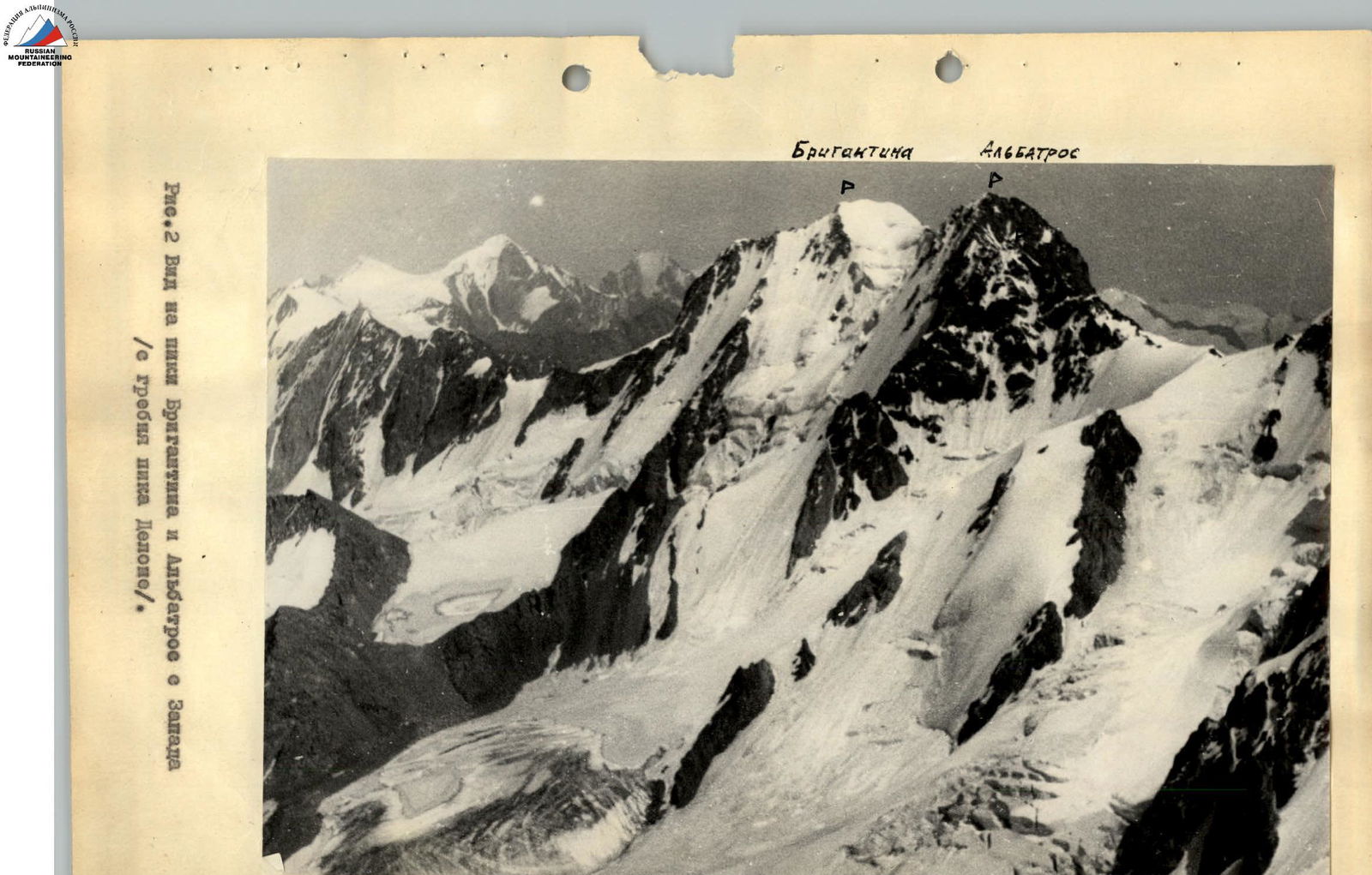
Brigantina (4850 m) Albatros (East. 4800 m, West. 4740 m)
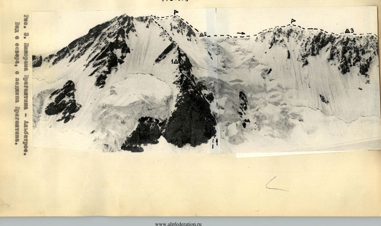
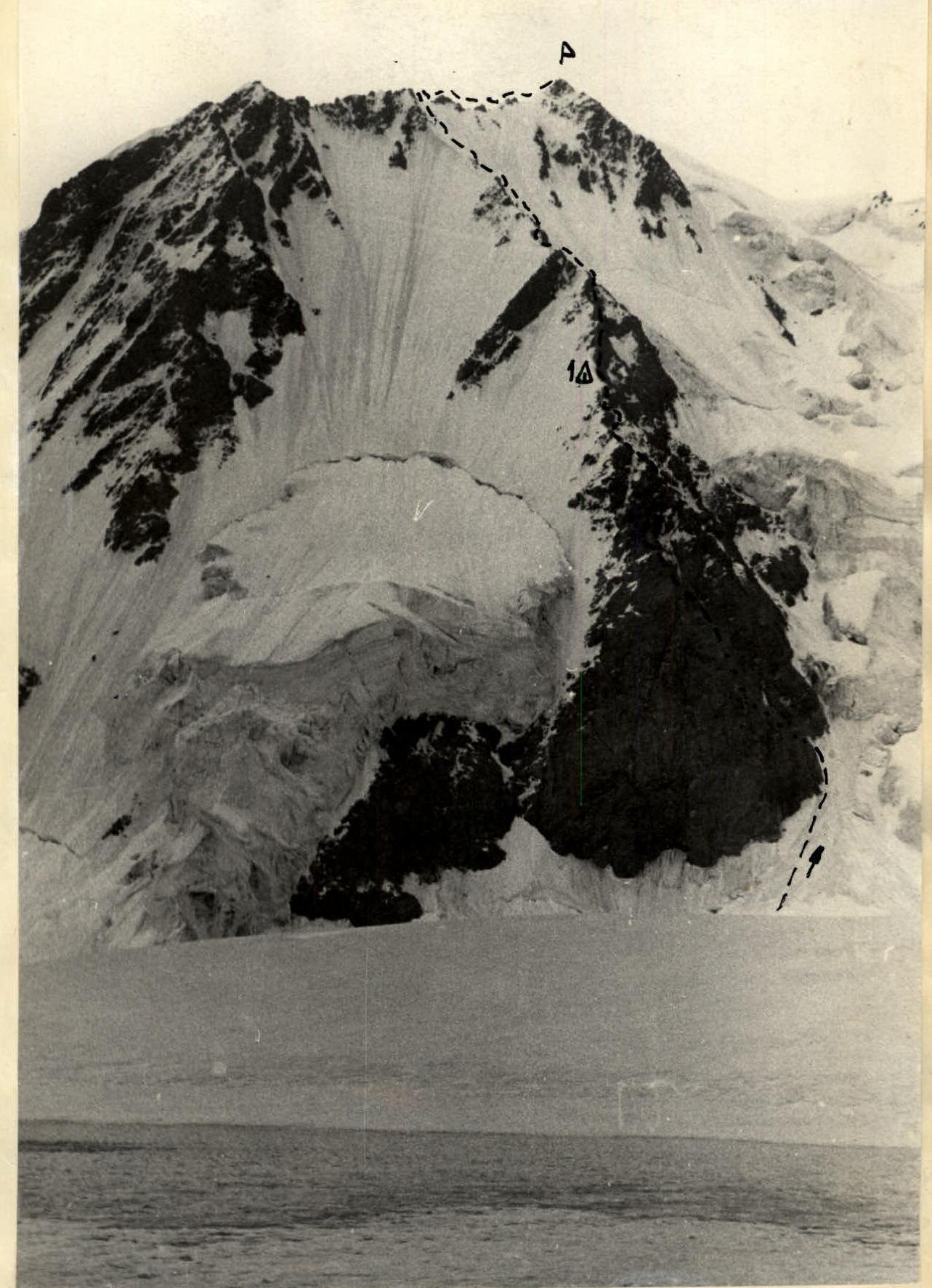
Fig. 4. Northern and northwestern ridges of Pik Brigantina (view from the north from the Brigantina glacier).
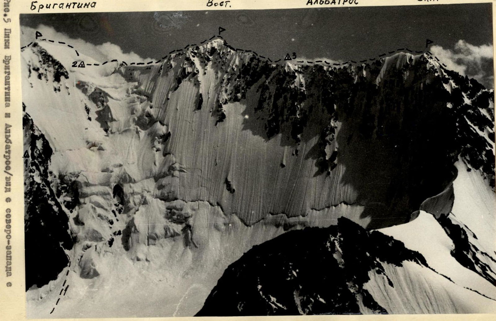
Fig. 5. Pik Brigantina and Albatros (view from the northwest from the summit of Pik Krazor).

Fig. 16. Eastern ridge of Pik Albatros (East).
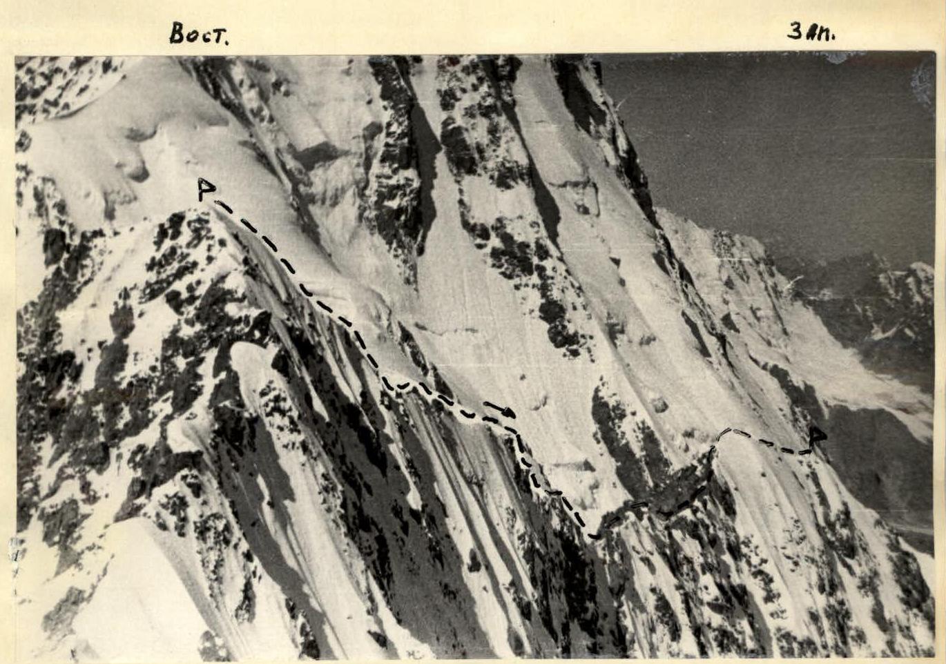
Fig. 16a. Eastern and Western peaks of Pik Albatros.
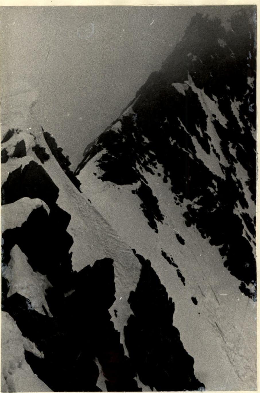
Fig. 22. Descent from the summit of Pik Albatros (East) along the western ridge.


