I. Climbing category: Technical 2. Climbing area: Tian Shan, Terskey-Alatau ridge 3. Peak, its height, and ascent route: Pik Pamyati Blyukhera, 4720 m, via the North face and North ridge 4. Proposed difficulty category: 5B 5. Route characteristics: elevation gain 870 m, average slope 63°, average slope of the wall section 71°, length of sections with 5–6 difficulty category 225 m 6. Pitons driven:
| for belay | for artificial holds | |
|---|---|---|
| rock | 69 | 8 |
| ice | 12 | – |
| chocks | 21 | 2 |
- Total climbing hours: 21 hours
- Number of bivouacs and their characteristics: 1 bivouac, sitting, on a carved and stone-lined ice ledge
- Team name: MGS SDSO "Burevestnik" (MAI)
- Surname, first name, patronymic of the team leader, participants, and their sports qualification: Kachurovsky Konstantin Artemovich, 1st sports category, team leader; Filimonov Yuri Lvovich, 1st sports category; Sdobnikov Evgeny Yuryevich, 1st sports category; Yantsevich Anatoly Kuzmich, 1st sports category.
- Team coaches: Puchkov Lev Nikolaevich, Master of Sports, Honored Coach of the RSFSR; Zinin Mikhail Ivanovich, Master of Sports.
- Date of departure and return: July 24, 1979 – July 26, 1979
B. Base camp
Group bivouac → Group route
Map of the climbing area
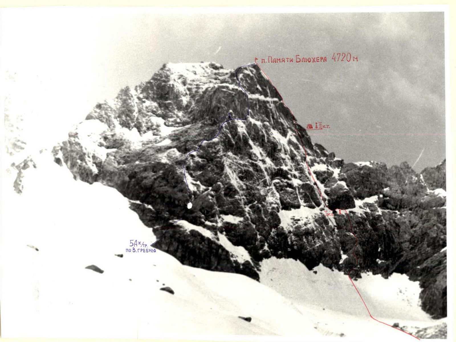
The slopes lack clearly defined avalanche collection gullies, so after bad weather, there is a high probability of avalanches occurring anywhere. Two route options along indistinct counterforts in the western part of the wall were considered the safest. The sheer, in some places overhanging, slabs at the base of the wall make it illogical to exit onto the left counterfort in the lower part of the wall. In connection with this, the team planned to ascend via the right counterfort of the North face with an exit onto the North ridge of Pik Pamyati Blyukhera. During preparation for the first ascent of Pik Pamyati Blyukhera, the group, in the same composition, climbed Pik Dzhigit (5170 m) via the Serpents of the North face, category 5B.
Description of the route passage
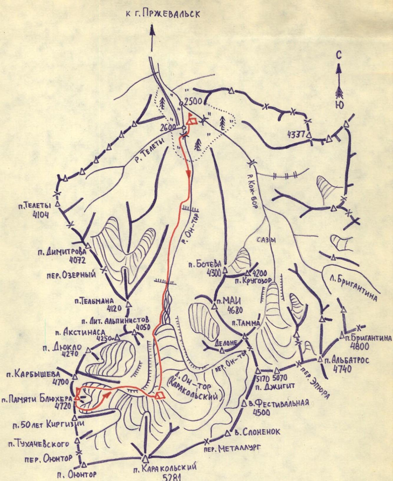
July 24, 1979. The group departed from the "ALA-TOO" base camp, located at the confluence of the On-ter and Kok-bor rivers, at an altitude of 2600 m. After a four-hour approach, they set up a bivouac on the moraine of the Karakolsky glacier. The last two hours were marked by heavy snowfall with thunderstorms. Overnight.
July 25, 1979. The departure, scheduled for 4:00 AM, was postponed due to snowfall with thunderstorms and strong gusty winds. A slight improvement in the weather allowed them to leave the bivouac at 6:00 AM. Movement proceeded along the left tributary of the Karakolsky glacier and the lateral moraine of the Karbyshev glacier.
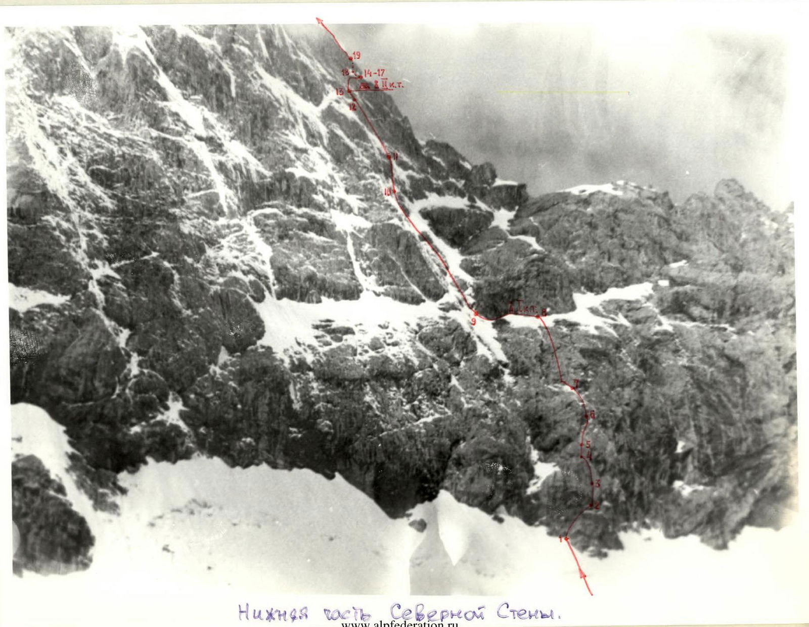
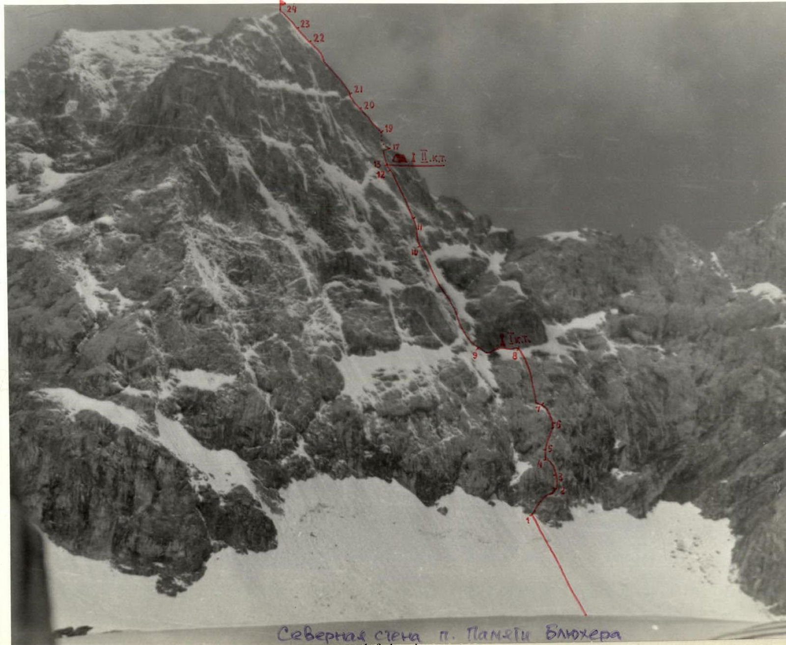
Lower part of the North face. They ascended to the ice plateau at 3850 m in the cirque of the Karbyshev and Pik Pamyati Blyukhera peaks. They approached the avalanche cones of the North face of Pik Pamyati Blyukhera via a closed, heavily crevassed glacier. Inspecting the lower part of the wall confirmed the correctness and logic of the planned ascent route. The starting point of the route is marked by a gully separating the right counterfort of the North face from the rock walls under the saddle between Pik Karbyshev and Pik Pamyati Blyukhera. From the glacier, they ascended a steep snowy slope to the bergschrund (40 m, 40°). After crossing it via a snow bridge and navigating a slope with deep loose snow, they reached the base of the rock wall (20 m, 45°). They then entered the rocks. The rust-colored rocks with horizontal bands at the mouth of the gully were ascended to the right and upwards (40 m, 45°), bypassing an overhanging wall. A sheer rock wall blocking their path was overcome via an internal corner crossing it to the left and upwards (25 m, 85°, challenging climbing, artificial holds), followed by an exit above the wall via moderately difficult rocks (30 m, 65°). The next smoothed slab was ascended directly upwards (10 m, 80°, pitons, ladder). From a ledge above the slab, they moved to the right and upwards across wet slabs (20 m, 60°) and then to the left and upwards via challenging rocks (25 m, 75°, challenging climbing, ladder) to reach a balcony under a large smooth slab. They ascended the slab directly upwards to the first snowy belt under a black overhanging wall (70 m, 65°). The wall was bypassed via ledges traversed to the left (40 m, rock and ice pitons). They fixed the I control cairn on the wall. From the cairn under the wall, they traversed to the left, avoiding a large freestanding spall, crossed the gully, and exited onto the slabs of the right counterfort of the North face (40 m, pitons). The slabs were heavily iced and covered with fresh snow, making it difficult to maintain traction with Vibram boots. They had to put on crampons and continued the route in them. The route continued:
- Up the right part of the counterfort via slabs with few holds, 150 m directly upwards (60°)
- To a sheer wall
- Along the right edge of the destroyed part of the wall (40 m, 80°)
- To steep iced rocks
The snowfall, which had continued throughout the day, stopped, and it became significantly colder. The damp ropes had frozen, making it difficult to use ascenders, which complicated the passage of subsequent pitches.
The search for a suitable bivouac site yielded no results so far. They continued moving. They ascended steep iced rocks and an oblique internal corner covered with snow, moving to the left and upwards under a spall (80 m, 90–60°).
Then, through a small overhang (7 m, 95°, artificial holds), they exited onto a ledge on the spall. After the first control cairn, this area proved to be the only suitable place for organizing a bivouac. An hour and a half of "sculpting" a platform from snow and slabs
 allowed them to establish a tolerable sitting bivouac by 21:00. They also fixed the II control cairn on a slab above the platform.
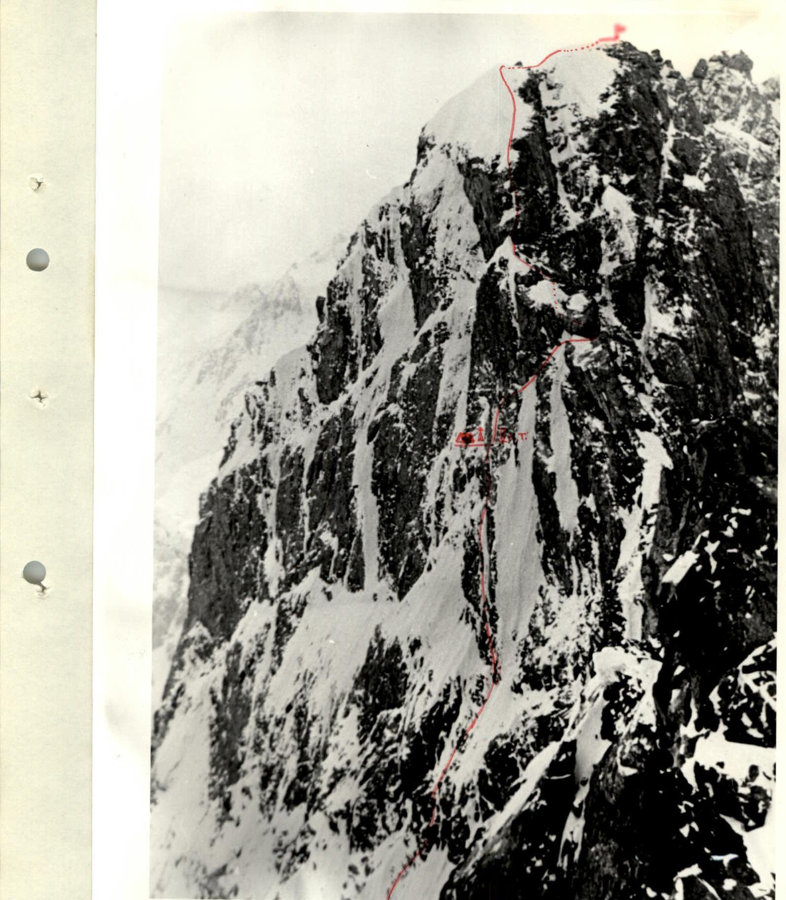
July 26, 1979. They departed from the bivouac at 6:30 AM. After analyzing the upper part of the route, they decided that continuing along the North ridge of Pik Pamyati Blyukhera was the most logical course of action.
The morning was clear and cold. From the platform, they ascended upwards via smoothed slabs (25 m, 75°) and then to the right through a rock ridge (15 m, 70°) under an overhanging wall. The wall was overcome vertically upwards using ladders (8 m, 95°) and exited onto a ledge leading onto the ridge under an overhanging ascent on the North ridge. The ascent was bypassed by traversing to the right along the ledge (20 m), then via sheer iced slabs and a cleft (25 m, 90°, artificial holds) and moderately difficult rocks (25 m, 60°) to reach the ridge.
Along the ridge, through a 15-meter rock face (75°, artificial holds) and further via heavily snow-covered slabs and moderately difficult rocks (120 m, 55°), they approached the pre-summit ice ridge. Up a steep ice slope (70 m, 50°) and a snowy ridge (50 m, 30°, cornices), they reached the summit.
They were on the summit at 15:30. They descended from the summit via the South ridge to the saddle and then down a snowy gully onto the Karbyshev glacier. They returned to the base camp the same day.
allowed them to establish a tolerable sitting bivouac by 21:00. They also fixed the II control cairn on a slab above the platform.
July 26, 1979. They departed from the bivouac at 6:30 AM. After analyzing the upper part of the route, they decided that continuing along the North ridge of Pik Pamyati Blyukhera was the most logical course of action.
The morning was clear and cold. From the platform, they ascended upwards via smoothed slabs (25 m, 75°) and then to the right through a rock ridge (15 m, 70°) under an overhanging wall. The wall was overcome vertically upwards using ladders (8 m, 95°) and exited onto a ledge leading onto the ridge under an overhanging ascent on the North ridge. The ascent was bypassed by traversing to the right along the ledge (20 m), then via sheer iced slabs and a cleft (25 m, 90°, artificial holds) and moderately difficult rocks (25 m, 60°) to reach the ridge.
Along the ridge, through a 15-meter rock face (75°, artificial holds) and further via heavily snow-covered slabs and moderately difficult rocks (120 m, 55°), they approached the pre-summit ice ridge. Up a steep ice slope (70 m, 50°) and a snowy ridge (50 m, 30°, cornices), they reached the summit.
They were on the summit at 15:30. They descended from the summit via the South ridge to the saddle and then down a snowy gully onto the Karbyshev glacier. They returned to the base camp the same day.
Table of route sections
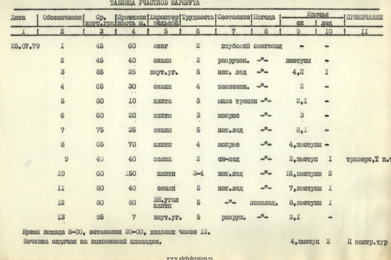
| Date | Section | Avg. slope (deg.) | Length (m) | Terrain type | Diff. cat. | Condition | Weather | Rock pitons | Ice pitons | Notes |
|---|---|---|---|---|---|---|---|---|---|---|
| 25.07.1979 | R1 | 45 | 60 | snow | 2 | deep | snowfall | – | – | |
| R2 | 45 | 40 | rocks | 2 | destroyed | «-» | ledges | – | ||
| R3 | 85 | 25 | internal corner | 5 | wet ice | «-» | 4.P | 1 | ||
| R4 | 65 | 30 | rocks | 4 | snow-covered | «-» | 2 | – | ||
| R5 | 80 | 10 | slab | 5 | few cracks | «-» | 2,1 | – | ||
| R6 | 60 | 20 | slabs | 3 | wet | «-» | 3 | – | ||
| R7 | 75 | 25 | rocks | 5 | wet ice | «-» | 8,1 | – | ||
| R8 | 65 | 70 | slabs | 4 | wet | «-» | 4, ledges | – | ||
| R9 | 40 | 40 | ledge | 2 | snow-ice | «-» | 2, ledge | 1 | traverse, T k. | |
| R10 | 60 | 150 | slabs | 3–4 | wet ice | «-» | 16, ledges | 2 | ||
| R11 | 80 | 40 | rocks | 5 | wet ice | «-» | 7, ledges | 1 | ||
| R12 | 80 | 80 | internal corner | 5 | «-» | colder | 8, ledges | 1 | ||
| R13 | 95 | 7 | internal corner | 5 | destroyed | «-» | 2,1 | – | ||
| 26.07.1979 | R14 | 75 | 25 | slabs | 4 | smoothed | clear | 3 | – | |
| R15 | 70 | 15 | rocks | 3 | snow-covered | «-» | 2, ledges | – | ||
| R16 | 95 | 8 | slab | 6 | few cracks | «-» | 2.P | – | ||
| R17 | 50 | 20 | ledge | 3 | snow-covered | «-» | 1 | – | traverse | |
| R18 | 60 | 25 | ledge | 4 | iced | «-» | 1, ledge | – | traverse | |
| R19 | 90 | 25 | slab, cleft | 6 | wet ice | «-» | 4.P | – | ||
| R20 | 60 | 25 | rocks | 4 | destroyed | «-» | 1, ledge | – | ||
| R21 | 75 | 15 | rocks | 5 | few holds | «-» | 2,1 | – | ||
| R22 | 55 | 120 | slabs | 4 | snow-covered | «-» | 11, ledges | – | ||
| R23 | 50 | 70 | ice | 4 | snow layer | «-» | 2 | 4 | rock outcrops | |
| R24 | 30 | 50 | snowy ridge | 3 | cornices | «-» | simultaneously | – |
Departure time 8:00, stop time 20:00, climbing hours 12. Bivouac was on a constructed platform (4, ledge 2, I control cairn). Total pitons driven: rock 90 (including 21 chocks); ice 12; for artificial holds 10.