Ascent Passport
- Ascent class — technical
- Ascent area — Central Tien Shan, Teskey Ala-Too ridge, Jety-Oguz gorge
- Peak — Pik Yunost, 4300 m, ascent route via the South ridge
- Estimated difficulty category — 2B
- Route characteristics: elevation gain — 454 m, length of sections with 3–4 difficulty category — 850 m, average steepness 55°
- Pitons driven: for rock protection — 22, ice — 0, bolted — 0
- Number of climbing hours — II
- Number of nights and their characteristics — 0
- Surname, name, patronymic of the leader, participants, and their qualifications: AL'KOV Yuriy Evgen'evich — leader, 2nd sports category; EVSEENKO Tatyana Pavlovna — participant, 2nd sports category; ZAVARZIN Yuriy Timofeevich — participant, 2nd sports category; TESLENKO Sergey Tikhonovich — participant, 2nd sports category.
- Team coach — BIRYUKOV V.N.
- Date of departure for the route — July 26, 1978
return — July 26, 1978
Brief description of approaches to the route
Pik Yunost — 4300 m (the height of the peak is given based on a 1:100,000 scale topographic survey) is located in the northern spur of the Teskey Ala-Too watershed ridge in the upper reaches of the left tributary of the Jety-Oguz river — Baytor river. (See map scheme.) From Przhevalsk city, take a bus to the "Jety-Oguz" resort. Then, along the Jety-Oguz gorge, follow the road to the Telety gorge. Just above the Telety tributary, it is convenient to set up a base camp. Then, on foot, along the Jety-Oguz gorge, to the fork leading to the Baytor gorge. Ford the river, then cross over a log to the left bank of the Jety-Oguz river. (You can cross to the left bank of the Jety-Oguz river immediately at the Telety campsite.) Along the Baytor gorge to the fork, then along the left bank of the Baytor river, ascend to the Baytor campsite. Movement is everywhere along a horse trail. From Telety to the Baytor campsite is about 4–5 hours with full backpacks. The campsite has clean water, and the entire campsite is a good grassy area. From the campsite:
- 2–2.5 hours of walking along grassy slopes,
- along the right bank of the lake,
- along the moraine under the route. The route is not visible from the campsite. Thus, the approaches to the route take 2 hours by car and 6–7.5 hours on foot, i.e., one full working day.
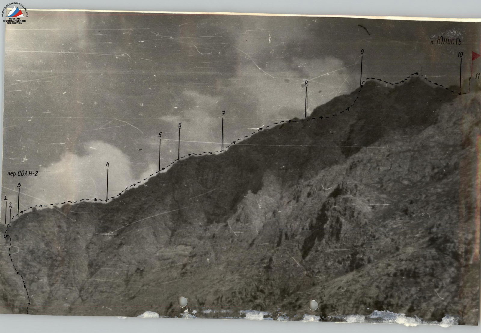
Table of main characteristics of the ascent route

| Section designation | Steepness (in °) | Length (in m) | Relief character | Difficulty category | Relief state | Weather | Pitons (rock/prot.) | Pitons (ice) | Pitons (bolted) | Notes |
|---|---|---|---|---|---|---|---|---|---|---|
| R0–R1 | 60 | 200 | Rocky couloir | 2–3 | Clean, dry | Sunny, warm | 2 | 0 | 0 | Exit to camp 4:00; Exit to route 6:00 |
| R1–R2 | 70 | 20 | Wall | 3 | Destroyed rocks | " | 2 | 0 | 0 | |
| R2–R3 | 60–80 | 60 | Wall | 3–4 | " | " | 3/5 | 0 | 0 | |
| R3–R4 | 30–45 | 200 | Ridge | 3 | Clean rocks | " | 0/30 | 0 | 0 | |
| R4–R5 | 45 | 200 | " | 3 | Destroyed rocks, ledges | " | 2/2 | 0 | 0 | |
| R5–R6 | 50–60 | 80 | " | 3–4 | Clean rocks, walls | " | 5/0 | 0 | 0 | |
| R6–R7 | 30–40 | 80 | " | 2–3 | Clean rocks | " | 0 | 0 | 0 | Simultaneous movement |
| R7–R8 | 35–40 | 200 | Rocks | 3 | " | " | 3/3 | 0 | 0 | |
| R8–R9 | 50–60 | 100 | Rocks | 3 | Rocky ledges | " | 3/4 | 0 | 0 | |
| R9–R10 | 30–40–70 | 100 | Towers | 3 | Ledges, snow patches | " | 0/6 | 0 | 0 | |
| R10–R11 | 80 | 40 | Tower | 4 | Wall | " | 2/5 | 0 | 0 | Reach the summit 17:00. Descent via 3A |
Total: average steepness 50°. Total length 1280 m. Length of sections with 3–4 difficulty category 850 m. Notation: numerator — rock pitons, denominator — rock features.
Brief explanation of the table
R0–R1. Ascending to the SOAN-2 pass is not difficult. Only at the end of the rocky couloir is there a 10 m high wall with a steepness of 80°. R1–R2. From the pass, move to the right. Descend down, left, along the wall. R2–R3. Ascend to the ridge along the wall, via narrow ledges, and destroyed rocks. R3–R7. Move along the ridge, bypassing all obstacles on the right. R7–R8. Move to the right of the ridge. R8–R9. Ascend to the sub-summit. R9–R10. Traverse the first two towers of the sub-summit. R10–R11. Ascend to the third tower (summit) via a very steep wall.

