Passport
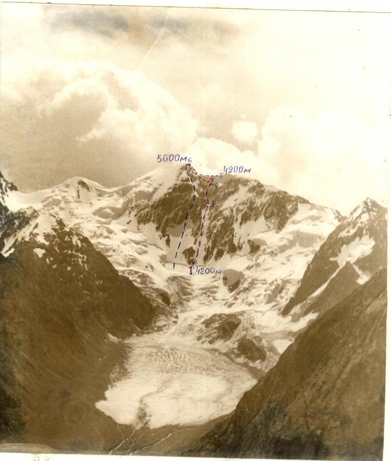
I. Class — ice and snow. 2. Terskey-Ala-Too, Jety-Oguz gorge. 3. Peak Oguz-Baschi 2nd Western, via the ice couloir on the North face. 4. Proposed 5B category difficulty, first ascent. 5. Height difference: total — 840 m; wall section — 740 m, its length 838 m, average steepness — 65°. Length of sections with VI category difficulty — 38 m, V — 800 m. 6. Pitons driven:
| Ice | Snow |
|---|---|
| 225 | 2 |
| 17 | 2 |
- Team's climbing hours: 17 hours (ascent).
- Overnight stays: none.
- Team leader: Barchuk Alexander Nikolayevich, Master of Sports of the USSR
Participants:
- Tregubov Pavel Vladimirovich, Candidate Master of Sports
- Kozyrev Nikolai Mikhailovich, Candidate Master of Sports
- Akbash Georgy Fedorovich, Candidate Master of Sports
- Coach: Klovanich Sergey Fedorovich.
- Start of the route: August 15, 1988. Summit — August 15, 1988, return — August 16, 1988.
- State Committee for Sports of the Moldavian SSR.
-
-
-
- Leontiev V.'s route, 1984
-
-
-
-
-
- Team's route.
-
-
Preparation for the Ascent
The team's overall preparation for the 1988 USSR Championship in the ice and snow climbing category was described in the report on the previous ascent. In addition to preliminary reconnaissance, the team reviewed this route during the descent from Peak Baitor and observed an attempt by the Leningrad GK team to climb the route. A consultation was obtained based on the results of this attempt.
It turned out that passing the last 10 m of the R9–R12 section with modern technical means made it highly problematic to ensure the safety of the first climber. Therefore, all attempts by the Leningrad team to pass this section independently were unsuccessful.
This section of the route was a snow cornice with a steepness of 115–120°. Our team manufactured special snow pitons for this section and, in addition to regular equipment, brought avalanche shovels. This equipment was tested before starting the route.
Tactical Actions of the Team
The team's movement scheme was similar to the one used in the previous ascent within the championship. However, the rope length was halved (to 25 m) to prevent injury to the belayer from ice fragments generated while the lead climber worked in the couloirs with a general vertical direction.
The interaction between the rope teams Barchuk A.N.–Akbash G.F. and Tregubov P.V.–Kozyrev N.M. was carried out according to the tactical plan on sections R1–R2, R2–R8, and R8–R41.
The load was distributed evenly among all team members.
The deviation from the time schedule was 3 hours (section R9–R12), caused by severe weather (heavy snowfall and thunderstorm from 9:30 until reaching the summit). The team had to wait out thunderstorm discharges twice, huddling together, and the overall temperature drop made it difficult to extract ice from ice pitons, reducing the team's speed.
Safety measures were similar to those used in the first ascent (see report № I). Due to fog, the observation team went out to listen every hour (see route sheet). Since the Leningrad GK team did not complete the route, our team considered it necessary to have a backup plan in case they could not ensure safety on the snow-ice cornice with an overhang of up to 10 m (see tactical plan).
Our team worked on section R9–R11 for over 5 hours, despite:
- hurricane-force winds,
- heavy snow charges.
Standard-sized ice pitons could not ensure safety — they were pulled out by hand from the snow-ice mass. Snow pitons were used only for movement and could not serve as belay elements.
Therefore, to ensure safety, the team decided:
- not to pass the last 5 m of the cornice,
- to bypass it on the left.
This decision was discussed in case of sharp weather deterioration (see tactical plan). Overall, the route variant with a bypass on the left of the 38-meter overhang is much more challenging than the route taken by the team on Peak Baitor and is considered logical and fully corresponding to the 5B category.
For information on environmental protection and the promotion of mountaineering, see report № I.
Scheme of the Section
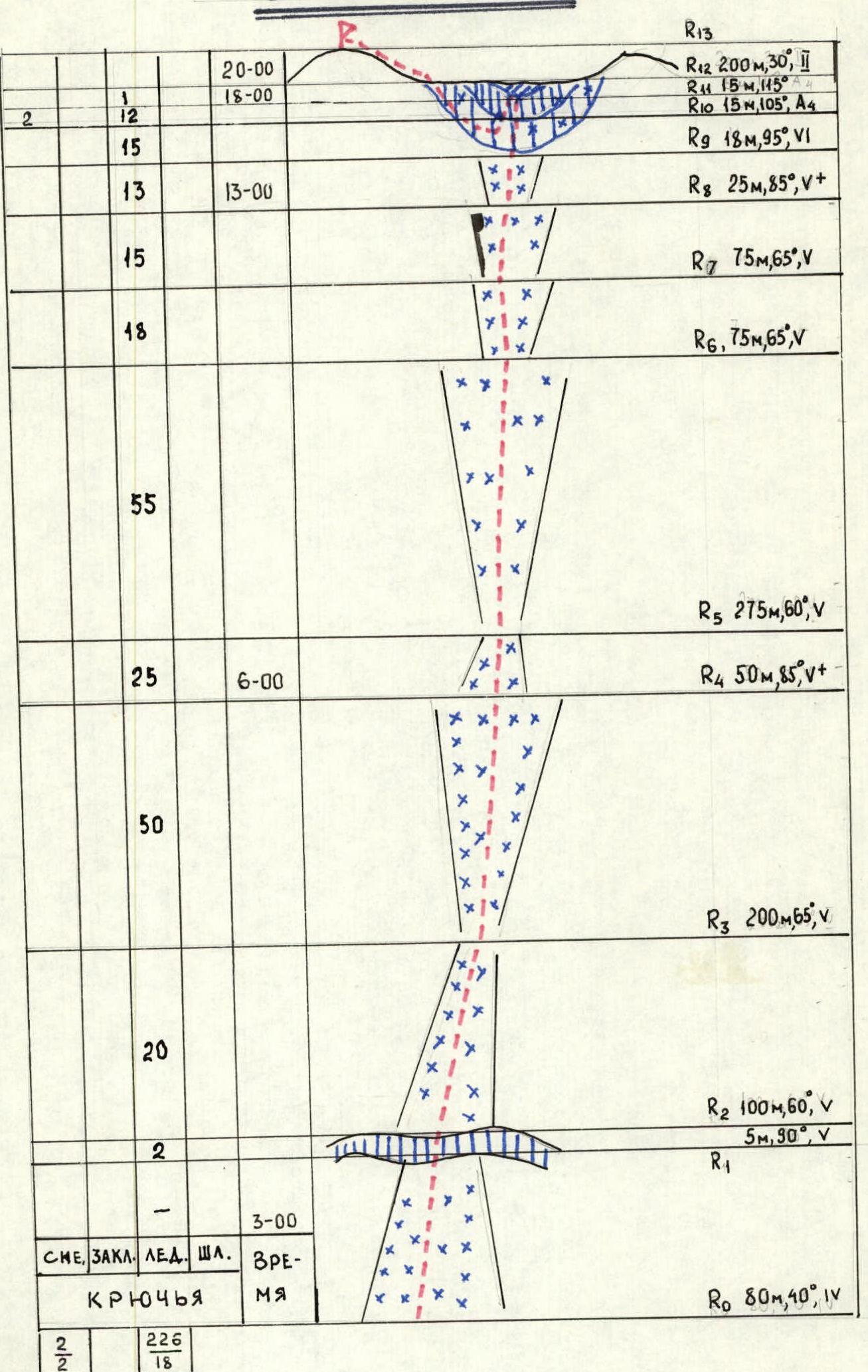
Scheme of sections (data from PDF page 5):
- R0: 80 m, 40°, IV
- R1
- R2: 100 m, 60°, V (including 5 m, 90°, V)
- R3: 200 m, 65°, V
- R4: 50 m, 85°, V+
- R5: 275 m, 60°, V
- R6: 75 m, 65°, V
- R7: 75 m, 65°, V
- R8: 25 m, 85°, V+
- R9: 18 m, 95°, VI
- R10: 15 m, 105°, A4
- R11: 15 m, 115°, 4
- R12: 200 m, 30°, II
- R13
Pitons placed (according to the scheme): Snow: 2 Total: 2 Ice: 226 Bolt: 18
Brief Description of the Approach to the Route
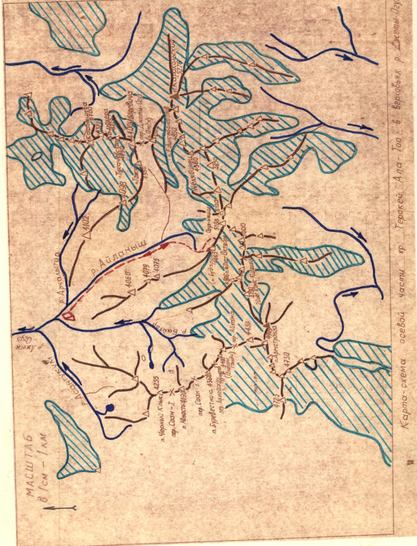 Peak named after N. Budarin (4062 m) is located at the beginning of the North-Western watershed spur of the Terskey-Ala-Too ridge. The spur is between the rivers:
- Aylanysh
- Baitor
(see map).
From Przhevalsk, drive by car to the Jety-Oguz resort and further along the gorge to the Telety river (12 km from the resort, 10 bridges over the river). Then, a 2–2.5 hour hike begins along the right (orographic) bank of the Jety-Oguz river to the fork (the gorge splits into the Baitor and Aylanysh gorges). From the confluence of the rivers, continue along the same bank of the Aylanysh river to the crossing (300 m). Cross to the other bank and 50 m downstream from the crossing is a very convenient spot for a base camp, which we used.
From the base camp, cross back to the right (orographic) bank of the Aylanysh river and move up along the slope upstream to the confluence with the Archaltyor river (800 m).
Cross the Archaltyor river by rocks and logs and return to the right bank of the Aylanysh river. After 200 m, cross the river again by a log bridge (2 logs) and wade through the shallow water. Then, move upwards towards the long moraine on the right. Climb onto the moraine and behind it, in a "pocket" between the moraine and the slope of the spur, is a convenient spot for an assault camp: there is water, no wind, and enough space for 6–10 tents.
From the base camp to this spot takes 2.5–3 hours. Climb along the crest of this moraine to the beginning of the North-East ridge of Peak named after N. Budarin.
Brief Description of the Route
The beginning of the ridge is bypassed on the right via "ram's foreheads" with scree shelves and snow patches (section 1). Through the left snow-ice couloir (40°, 10 m), exit to its right side (section 2), turning into a snow-ice slope (section 3). Reach the North-East ridge. The ridge is heavily destroyed; pass along scree shelves with simultaneous belay (section 4). Traverse the wall along an inclined snowy shelf to the right (section 5), then along rocks and snow upwards to the left (section 6). Ascend from the left of the ridge with a slight traverse along inclined shelves with alternate belay (section 7). Exit to the ridge and ascend via a crack. Organize a belay (section 8). Move along the ridge to a wide platform simultaneously. From there, the ridge alternates between inclined shelves and short walls. Movement is simultaneous and alternate (section 9). Before the summit tower, the ridge becomes more gentle with steps. Climb to a rock outcrop on the tower with alternate belay (section 10).
After section 7, it is possible to use a couloir on the right as an ascent variant, as done by the group led by Solovyov V.A. The beginning of the couloir is passed simultaneously (loose rocks). Then, the couloir turns into a chimney, which is climbed on its left side with alternate belay. 3 m from the end of the chimney, exit left to the ridge via wide scree shelves (160 m, 40°) to the base of a snowy couloir. Then:
- Along the couloir — 2 ropes of steep snow,
- Then along moderately difficult rocks on the left side of the couloir — exit to the summit.
The summit is a rocky tower; to the north lies a second tower. Between them is a saddle, partially covered in snow.
On the rock outcrop is a memorial plaque with a container for notes.
Descent. Along the South ridge to the saddle on the North-West ridge heading towards the Jety-Oguz wall. From there, a rocky couloir with scree shelves is visible.
Shelves:
- are smooth,
- slippery,
- with many loose rocks.
Descend to the end of the couloir. Traverse to a scree shelf to the start of the route. Then, descend along the ascent route.
Characteristics of the Sections
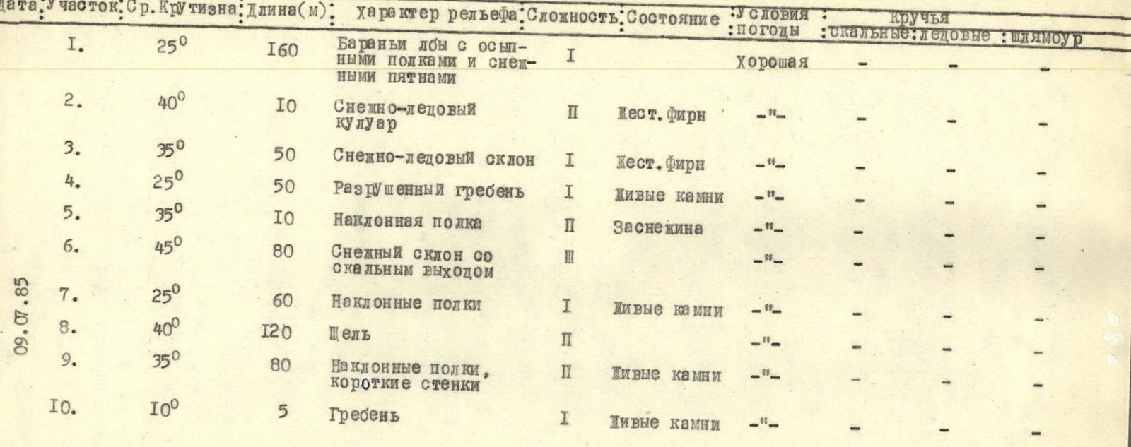
| Date | Section | Average Steepness (°) | Length (m) | Terrain Characteristics | Difficulty | Condition | Weather Conditions | Pitons (rock/ice/bolt) | |---|---|---|---|----------------------------------------|---|------------------|---| | | 1 | 25 | 160 | Ram's foreheads with scree shelves and snow patches | I | | Good | -/-/- | | | 2 | 40 | 10 | Snow-ice couloir | II | Hard firn | - | -/-/- | | | 3 | 35 | 50 | Snow-ice slope | I | Hard firn | - | -/-/- | | | 4 | 25 | 50 | Destroyed ridge | I | Loose rocks | - | -/-/- | | | 5 | 35 | 10 | Inclined shelf | II | Snow-covered | - | -/-/- | | | 6 | 45 | 80 | Snow slope with rock outcrops | II | | - | -/-/- | | 09.07.85 | 7 | 25 | 60 | Inclined shelves | I | Loose rocks | - | -/-/- | | 09.07.85 | 8 | 40 | 120 | Crack | II | | - | -/-/- | | 09.07.85 | 9 | 35 | 80 | Inclined shelves, short walls | II | Loose rocks | - | -/-/- | | 09.07.85 | 10 | 10 | 5 | Ridge | I | Loose rocks | - | -/-/- |
Peak named after Budarin
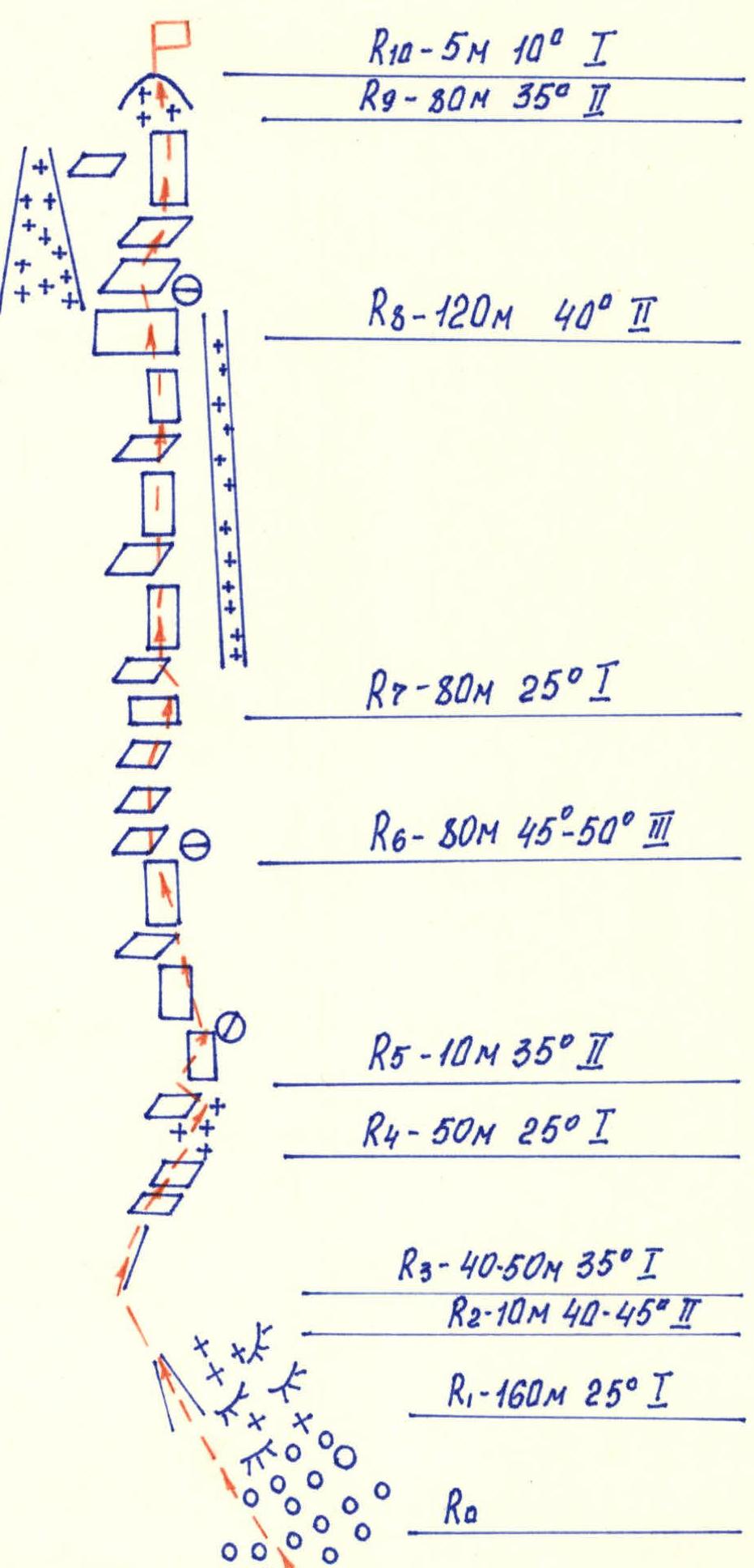
Scheme of the route (data from PDF page 10):
- R10: 5 m, 10°, I
- R9: 80 m, 35°, II
- R8: 120 m, 40°, II
- R7: 80 m, 25°, I
- R6: 80 m, 45°–50°, III
- R5: 10 m, 35°, I
- R4: 50 m, 25°, I
- R3: 40–50 m, 35°, I
- R2: 10 m, 40°–45°, II
- R1: 160 m, 25°, I
- R0