Ascent Log
- Ascent category - traverse
- Ascent area: Central Tien-Shan range, Terskey Ala-Too range, Jety-Oguz gorge.
- Peak, its height - traverse of peaks "Edinstvo narodov" 4840 m – 4850 m with ascent to peak 4840 m via the north face
- Proposed category of difficulty - 5B
- Ascent characteristics
height difference 1440 m, average steepness of the face 76°, length of the difficult section of 5–6 cat. diff., 1303 m.
- Pitons hammered
rock - 186, ice - 81, for creating ITO 15
-
Number of travel hours - 38
-
Number of nights and their characteristics:
- lying overnight stay
- sitting overnight stay
- lying overnight stay
- lying overnight stay
-
Surname, name, patronymic of the leader, participants and their qualification.
- Popov F.E. - leader, CMS - instructor
- Kudashkin Yu.V. - participant, CMS - instructor
- Kuzmenko B.S. - participant, CMS
- Alibegasvhili L.M. - participant, CMS - instructor
-
Team coach Popov F.E.
-
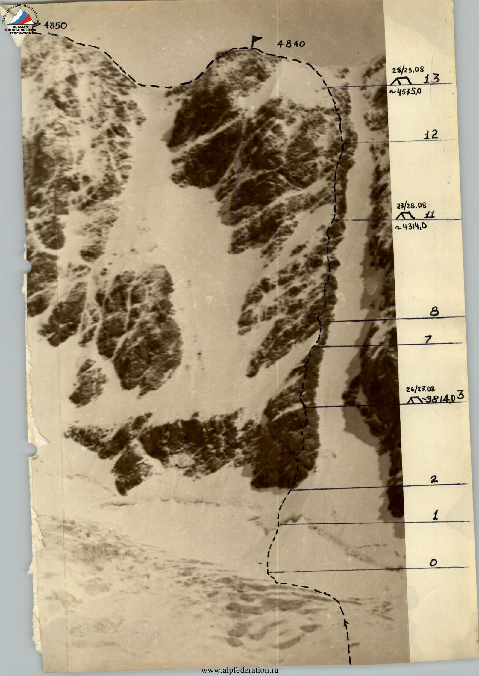
Departure date July 26, 1977 return date July 30, 1977
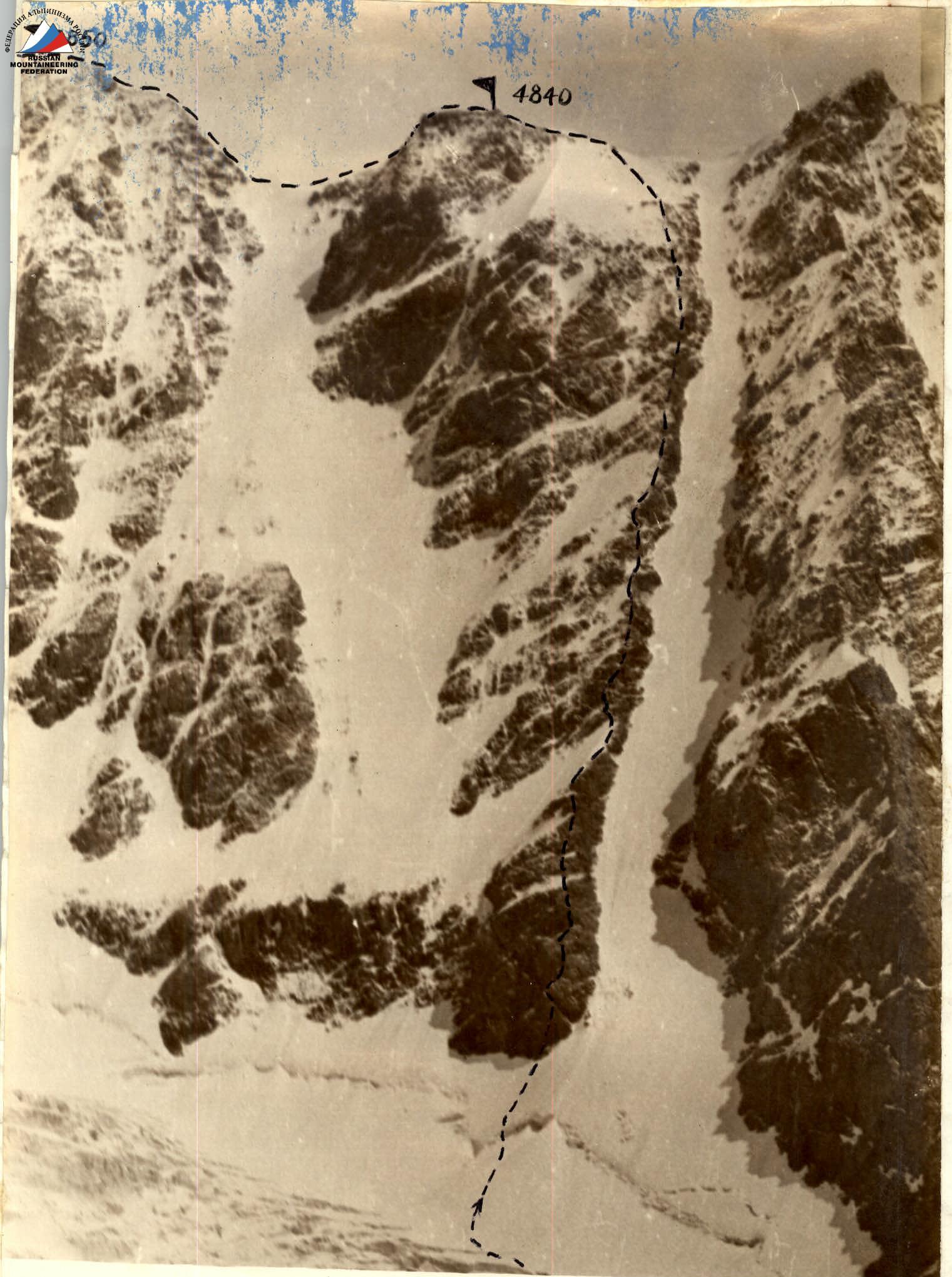
ROUTE TAKEN BY THE GROUP. 
MAP SCHEME OF THE AXIAL PART OF THE TERSKEY-ALATAU RANGE IN THE UPPER REACHES OF THE JETY-OGUZ RIVER.
Brief explanation for the table.
Movement through the right couloir is impossible due to rockfall danger. Constantly exposed. The face is lit in the morning and evening, and from 1:00 PM to 3:00 PM it is in shadow and the intensity of rockfall decreases.
0–1 Ice slope, 60°, standing in the lower, more gentle part, covered with snow 6–10 m deep. Ascent in crampons with piton protection. Traces of falling rocks visible on the snow.
1–2 Bergschrund is traversed via an ice bridge and then on pure ice with front-pointing crampons and piton protection. In the upper part, step-cutting begins - 12 m under the rocks.
2–3 Exit onto the rocks. The randkluft is overcome by descending 2 m into it and emerging onto smoothed rocks to a 5 m wide ledge, no cracks. Protection on the ledge. Further, more degraded rocks with many wide cracks follow. Ascent via a less distinct counterfort with piton protection, bypassing bastions 5–10 m to the right and left. Caution: many loose rocks!
3–6 Heavily degraded wall in the upper part, transitioning into an internal corner 70 m, 90°. Move with caution, especially in the lower part - loose rocks. In the internal corner:
- Large cracks for pitons
- Rocks not degraded
Climbing is difficult, rucksacks were pulled up.
6–8 Degraded rocks with many holds, featuring:
- Cracks for pitons
- Ledges for protection
Degraded rocks lead under an overhanging wall.
8–9 On the left part of the wall, a reddish patch is observed. To the left, 8 m away, is the shortest part of the overhanging wall. Directly under the wall, we emerge onto a frozen rock. A place for protection. 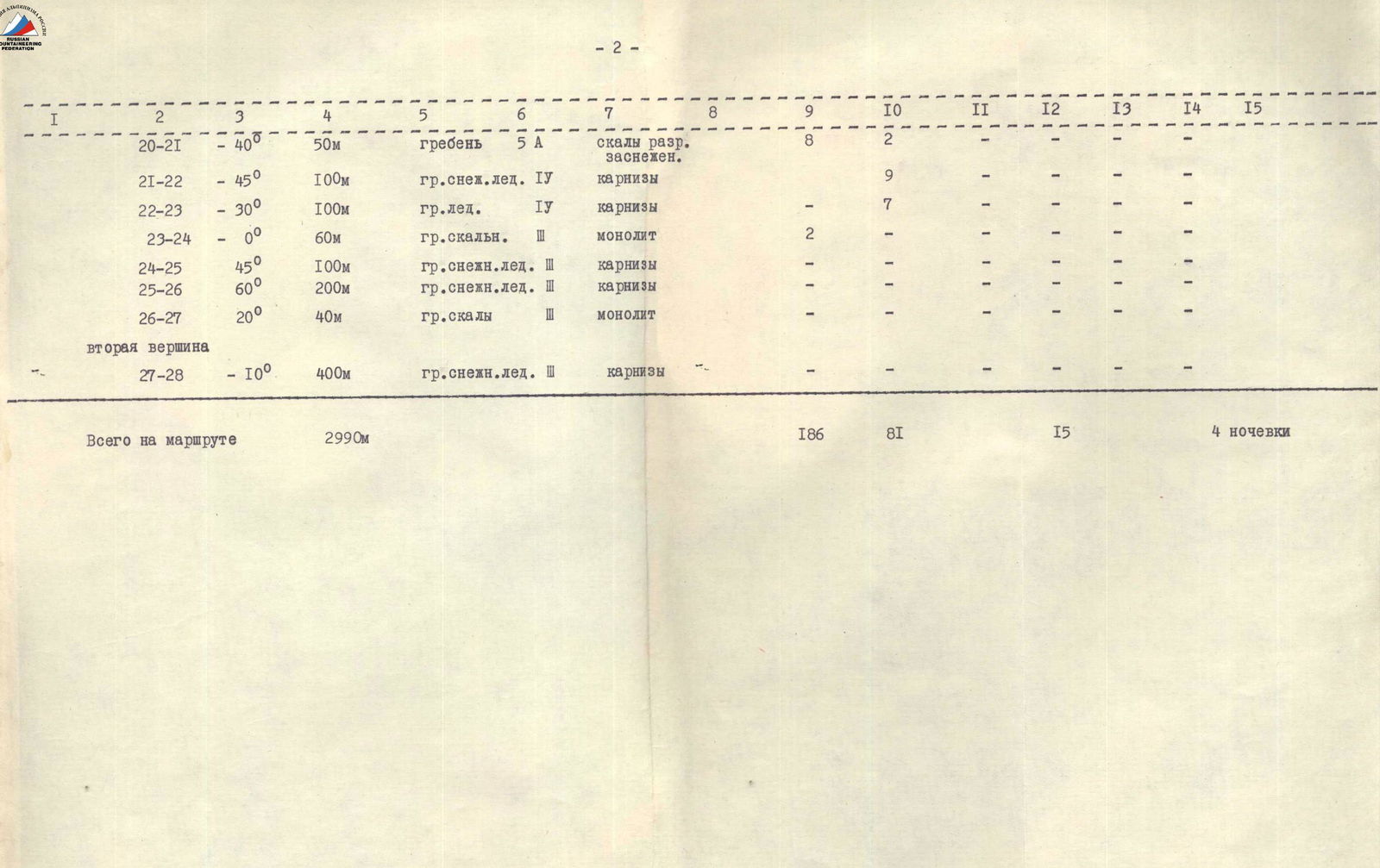
| 1 | 2 | 3 | 4 | 5 | 6 | 7 | 8 | 9 | 10 | 11 | 12 | 13 | 14 | 15 |
|---|---|---|---|---|---|---|---|---|---|---|---|---|---|---|
| 20–21 | 40° | 50 m | ridge | 5A | degraded rocks, snowy | 8 | 2 | |||||||
| 21–22 | 45° | 100 m | snowy-icy ridge | 4 | cornices | 9 | ||||||||
| 22–23 | 30° | 100 m | icy ridge | 4 | cornices | - | 7 | |||||||
| 23–24 | 0° | 60 m | rocky ridge | 3 | monolith | 2 | ||||||||
| 24–25 | 45° | 100 m | snowy-icy ridge | 3 | cornices | - | ||||||||
| 25–26 | 60° | 200 m | snowy-icy ridge | 3 | cornices | - | ||||||||
| 26–27 | 20° | 40 m | rocky ridge | monolith |
Second peak.
| 1 | 2 | 3 | 4 | 5 | 6 | 7 | 8 | 9 | 10 | 11 | 12 | 13 | 14 | 15 |
|---|---|---|---|---|---|---|---|---|---|---|---|---|---|---|
| 27–28 | 10° | 400 m | snowy-icy ridge | 3 | cornices | - |
Total on the route: 2990 m. Rock pitons: 186, ice pitons: 81, for ITO: 15. Nights: 4.
Then up and to the right along a slanting crack to the reddish patch and then up along an ice-filled crack.
9–11 Up the rocks, which are a continuation of sections 6–8, ascending while moving slightly to the right. Directly up, the wall is heavily degraded and hazardous. The rocks become gentler, less degraded. Bastions 10–15 m high are encountered, all bypassed on the left. In the upper part of the wall, a reddish bastion is ascended directly with rucksacks being pulled up.
11–13 Up rocks covered in ice, we ascend directly. The rocks transition into an icy slope, covered with snow. Crampons are used, with frequent stops. Piton protection.
13–28 Further movement along the main ridge.
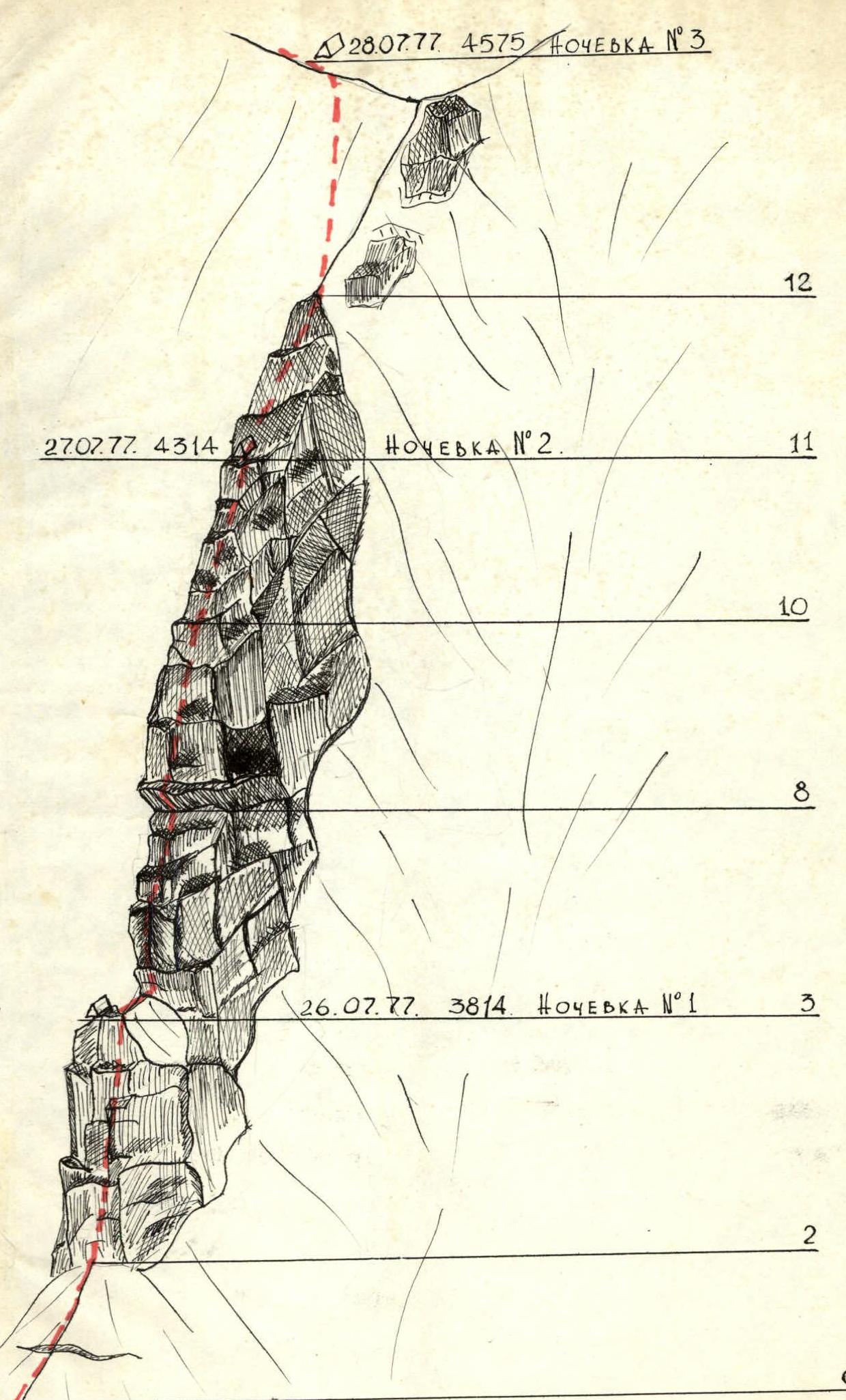
Profile of the wall section of the route. Peak 4840.