Technical category
Report
on the ascent (first ascent) to Peak Burevestnik (4360 m) via the North-East Ridge. Terskey Ala-Too Range
Team of the Kyrgyz RSS DSO "Spartak" consisting of:
- Orlov S.T.
- Alkov Yu.E.
Frunze
1978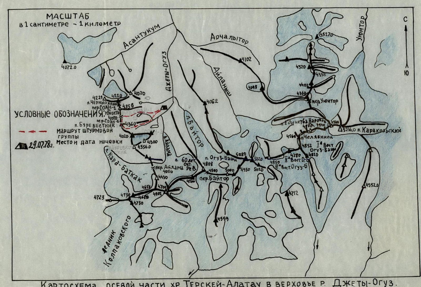
Map of the axial part of the Terskey Alatau Range in the upper reaches of the Jety-Oguz River.
Brief description of the approach to the route
Peak Burevestnik (4360 m) is located in the northern spur of the Terskey Ala-Too watershed range in the upper reaches of the left tributary of the Jety-Oguz River - the Bator River, in the left part of the Bator valley (see map).
The height of the peak is given based on the 1:100,000 scale topographic survey, published in 1962.
From Przhevalsk city by bus to the "Jety-Oguz" resort, then along the Jety-Oguz valley on the road to the Telety valley (12 km). Then on foot along the Jety-Oguz valley to the fork of the Bator valley. Ford to the left bank of the Jety-Oguz, then across a log to the left bank of the Bator tributary. It is possible to cross to the left bank of the Jety-Oguz River immediately at the Telety campsite.
Along the Bator valley to the fork, then along the left bank of the tributary ascend to the Bator campsite.
The movement is everywhere along the horse trail, from Telety to the Bator campsite is about 5-6 hours with full backpacks.
The campsite has clean water, and the entire campsite is a good grassy area.
From the campsite, it takes 2-3 hours of walking along grassy slopes and moraine to the route.
From the campsite, only the middle part of the route is visible.
Thus, the approach to the route takes:
- 2 hours by car;
- 7-9 hours on foot, i.e., one full working day.
Table of main route characteristics
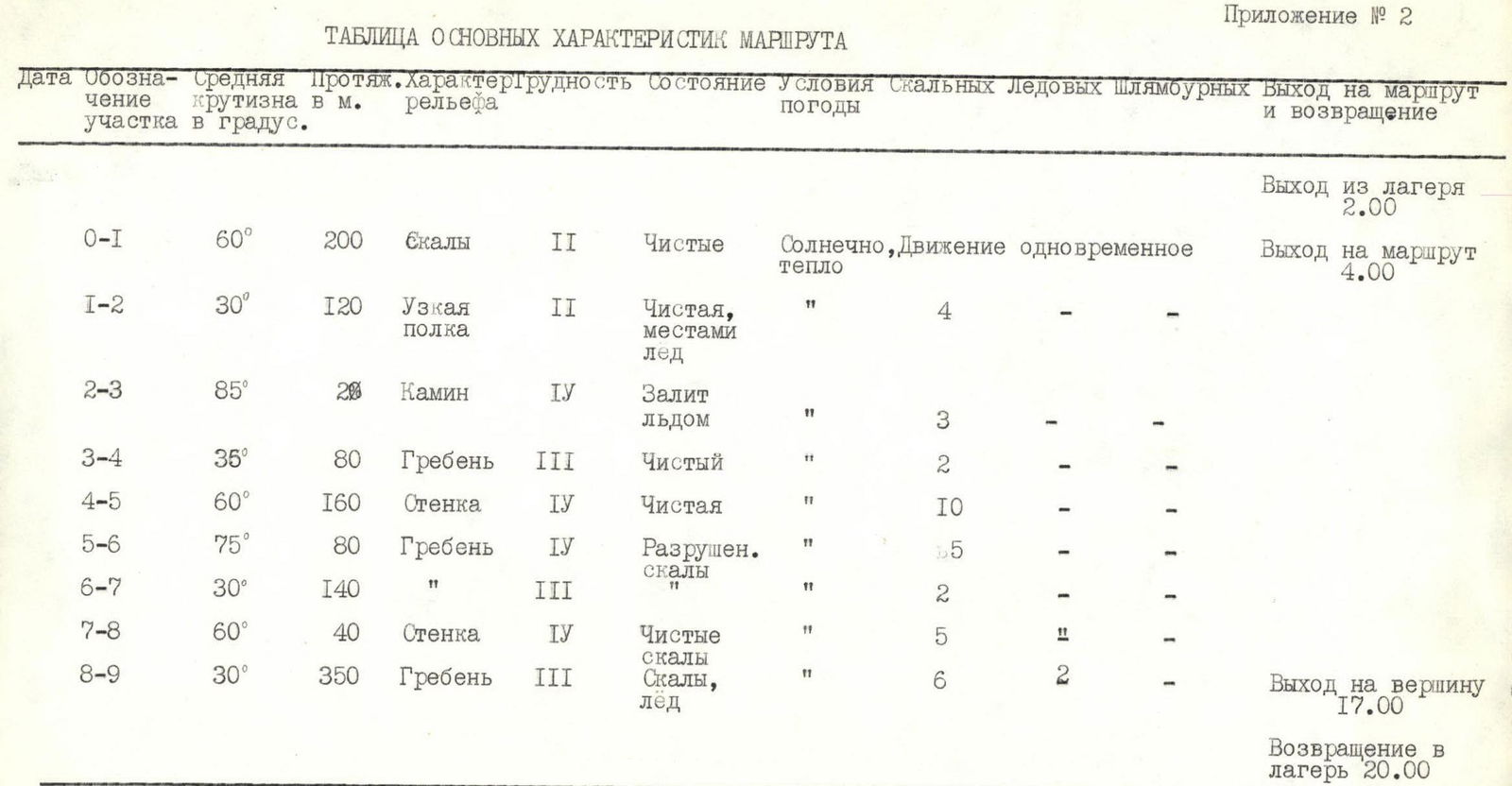
Appendix No. 2
| Section | Average steepness, ° | Length, m | Terrain type | Cat. diff. | Condition | Weather | Movement type | Rock belays | Ice screws | Bolted anchors | Departure / Return time |
|---|---|---|---|---|---|---|---|---|---|---|---|
| R0–R1 | 60 | 200 | Rocks | II | Clean | Sunny, warm | Simultaneous | 4 | – | – | Departure from camp 2:00 |
| R1–R2 | 30 | 120 | Narrow ledge | II | Clean, местами лед | " | – | – | – | Arrival at route 4:00 | |
| R2–R3 | 85 | 20 | Chimney | IV | Iced | " | 3 | – | – | ||
| R3–R4 | 35 | 80 | Ridge | III | Clean | " | 2 | – | – | ||
| R4–R5 | 60 | 160 | Wall | IV | Clean | " | 10 | – | – | ||
| R5–R6 | 75 | 80 | Ridge | IV | Broken rocks | " | 5 | – | – | ||
| R6–R7 | 30 | 140 | " | III | " | 2 | – | – | |||
| R7–R8 | 60 | 40 | Wall | IV | Clean rocks | " | 5 | – | – | ||
| R8–R9 | 30 | 350 | Ridge | III | Rocks, ice | " | 6 | 2 | – | Arrival at summit 17:00 | |
| Total | 1190 | 37 | 2 | – | Return to camp 20:00 | ||||||
| Average steepness | 51° |
The length of sections with IV category difficulty is 300 m.
Brief explanation of the table
R0–R1. The ascent to the SOAN-2 pass is not complicated. First, along wide ledges in the right part of the not clearly defined couloir under the wall with a steepness of 80-90° and a height of 10 m. The wall leads to the pass.
R1–R2. From the pass in a southerly direction along ledges to the right of the ridge. On the ledges, there are places with accumulated ice.
R2–R3. The ledges lead under the "Palets" pinnacle. Here is a 10-meter chimney filled with ice. It leads to the ridge.
R3–R4–R5. Further along the ridge under the wall. On the ridge, there are individual large stones. In some places, the rocks are covered with ice. In the upper part, the steepness of the wall increases to 80°.
R5–R6–R7–R8. The ridge is heavily serrated and broken. At the end of the R7–R8 section, there is a wall. At the end of the wall, there is a small negative section - 5 m.
R8–R9. The ridge is sharp, heavily serrated. In some places, there are ice sections up to 20 m. The exit to the summit is along a 40-meter ice slope with a steepness of 20°. Descent along the south-eastern slope to the moraine via route 3A.

0
