Passport
- Ice-snow class
- Terskey Ala-Too, Baytor gorge
- Peak Baytor (4700 m), via the icy couloir of the northern wall
- Proposed — 5B category of difficulty (second ascent)
- Elevation gain: 850 m, length — 1550 m.
Elevation gain of the main part of the route: 730 m, length — 910 m. Length of sections with 5th category of difficulty — 650 m. Average steepness of the main part of the route 52° (3850–4580 m).
- Pitons driven:
| Type of pitons | Rock | Bolt | Nuts | Ice |
|---|---|---|---|---|
| Driven | 12 | 0 | 7 | 173 |
| Available | 0 | 0 | 0 | 0 |
- Team's climbing hours: 10 h 30 min
- No overnight stays on the route.
- Team leader: Pershin Valery Nikolayevich, MS
Team members:
- Mingalev Vladimir Nikolayevich, MS
- Mamaev Sergey Vladimirovich, MS
- Ostanin Viktor Vasilyevich, MS
- Agafonov Alexander Alexandrovich, CMS
- Borisov Sergey Viktorovich, CMS
- Coach: Lebedikhin Alexey Veniaminovich, MSМК
- Start of the route: August 14, 1988 Summit — August 14, 1988 Return — August 14, 1988
- Organisation: Goskomsport RSFSR (RSFSR-I team).
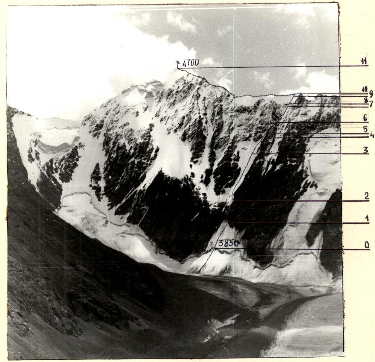
General photo of the summit
The photo was taken on August 7, 1988 at 14:00. Approximate distance to the object — 2.5 km, height of the shooting point — 3500 m. Lens — "Industar-50", focal length — 50 mm.
Tactical actions of the team
The team completed the ascent according to the tactical plan drawn up before the ascent. The movement schedule corresponded to the planned one, with a slight advance in the upper part of the route (the summit was reached 1 hour earlier).
The time of exit from the bivouac was chosen so as to reach the rocks by dawn. Working on the rocks in the dark is not advisable for safety reasons:
- the perspective is not visible;
- it is difficult to assess the degree of reliability of the supports;
- it is difficult to find cracks for pitons and nuts;
- in case of a stone fall from the first or following rope, those standing below will not be able to take a safe position.
On the other hand, one should not linger on the rocks. The rocks limiting the couloir on the right and having an eastern exposure pose a real danger on the route. It is not advisable to walk along them, as they are not a cover from stones, but their source when illuminated by the sun after 9:00.
At around 6:40, they started working on the rocks and reached the ice at the beginning of the ninth hour. They moved along the rocks to the left and upwards and reached the middle of the couloir. The stone-hazardous rocks remained on the right and no longer threatened us. The upper rocks above the couloir, due to the northern exposure, remain frozen until the evening and do not pose a danger when passing the icy slope in the morning and even during the day.
The participants were distributed in rope teams as follows:
- Pershin — Mamaev
- Ostanin — Mingalev
- Agafonov — Borisov
The first two rope teams used UIAA-I ropes for belaying, the third — a double GDR rope. On all sections up to the ridge (except for section R1–R2), the rope teams used ropes folded in half, i.e., worked on twenty-meter ropes.
For belaying on ice, ice screws were used:
- two intermediate ones per 20 m;
- two on belay stations.
On sections R0–R1, R2–R4, the rope teams moved as follows:
- Borisov (leader) — Agafonov and Mamaev-Pershin moved sequentially with alternate belaying without changing the leader.
- The lower rope team used ice screws screwed in by the first rope team, and as they moved, they passed them to the upper rope team.
- The Ostanin — Mingalev rope team (leader) moved autonomously in parallel with the first two rope teams.
This formation of rope teams allows the team to:
- Move compactly, at a constant speed throughout the day.
- Carry out interaction between two rope teams.
- To a certain extent, protect the lower participants from ice fragments falling from the tools and crampons of the upper participants. "The ice fragments do not have time to accelerate, since the length of the ropes is half."
On the rocks (section R1–R2):
- Pershin worked first on a double 40-meter rope.
- Then one rope was fixed on the railing, the remaining participants climbed up the railing with one jumar and top belay.
- Organisation of belaying — through rock pitons and nuts.
- The stations were a combination of three points: 2 pitons and 1 nut.
At the entrance to the diagonal gully at the end of section R3–R4 — a break. Here, they left a control cairn on a rock shelf (to the right of the route). After resting — a change of leaders in the rope teams.
Further on sections R4–R7, the movement of the rope teams is similar to the previous ice sections. At the end of section R6–R7, the rope teams rebuilt for sequential passage with the organisation of railing on sections:
- R7–R8
- R9–R10
Reached the ridge at 14:00. Further movement along the ridge with belaying through ledges on the rocky sections of the ridge. The weather starts to deteriorate, and as we reach the summit, we are caught up by a thunderstorm front. The "metal" started to "sing". Minimum time on the summit and down to descend from the zone saturated with electricity.
On the descent, we were extremely attentive, as the movement passed along a corniced ridge and the wet snow clogged the crampon teeth. Alternate movement with belaying through an ice axe or ice screws where there is ice.
Under the pass, they had a snack and then descended through the pass to the Aсан-туka glacier and into the observers' camp.
A characteristic feature of the route is that it is not possible to identify key sections. The route is even in difficulty and in the nature of the ice (with a crust of ice about 5 cm thick) along its entire length. The technical techniques for overcoming all sections of ice are of the same type. Movement on "front-pointing" with stirrups. We believe that movement on ice with a crust of ice is safer on "front-pointing" compared to impact tools, from which large pieces of ice break off and fly down to the lower climbers.
The team passed the route at a good pace, without reducing speed until the end of the route, with the organisation of reliable belaying, which indicates the presence of a physical and technical reserve among the team members. There were no falls or injuries during the ascent.
Although the ascent was planned and completed without an overnight stay, the team was prepared for an overnight stay: they had
- a tent;
- sleeping bags;
- insulating mats;
- a stove;
- an autoclave and food for two days.
During the ascent, altitude measurements were taken with an altimeter and the steepness of the sections was determined with an inclinometer.
Communication with the observers, whose tent was located opposite the route on the glacier moraine, was carried out using an RPT-70 radio station at set hours. The communication was stable.
In addition, visual observation of the team was carried out using a telescope throughout the ascent with a detailed record of the movement schedule.
In case of radio failure, the following was planned:
- light communication with conditional signals at night (at 23:00).
In case of an unforeseen delay on the route, an interaction was agreed upon with the RSFSR-2 team, which was climbing a parallel route on Peak Baytor a day later.
A rescue team of 7 people was located on the moraine during the ascent, observing the team. The rescue fund, as in the previous ascent, was located at the top in the observers' camp.
For the ascent, the group had a set of equipment and supplies similar to the previous ascent (see the team's report on the ascent of Peak Armstrong). Due to the presence of a rocky section, the number of rock pitons was increased to 15.
Route diagram in UIAA symbols
Scale: 1:2000
| Pitons | Nuts | Difficulty | Length (m) | Steepness, deg. | |
|---|---|---|---|---|---|
| Ice | Rock | ||||
| :----: | :------: | :--: | :-------: | :-------: | :-------------: |
| 4 | - | - | 5 У | 20 | 54 |
| 16 | - | - | 4 У | 75 | 54 |
| 66 | - | - | 3 У | 320 | 52 |
| Note: The section is not to scale. | |||||
| 6 | 12 | 7 | 2 IV+ | 100 | 55 |
| 34 | - | - | 1 IУ+ | 160 | 47 |
Note: The section is not to scale. Total climbing hours: 10.5 h. Total ice pitons: 173, rock: 12, nuts: 7.
| Pitons | Nuts | Difficulty | Length (m) | Steepness, deg. | |
|---|---|---|---|---|---|
| Ice | Rock | ||||
| :----: | :------: | :--: | :-------: | :-------: | :-------------: |
| 5 | - | - | 10 У+ | 25 | 57 |
 |
| 10 | - | - | 9 У | 50 | 53 |
| 4 | - | - | 8 У+ | 20 | 60 |

| 12 | - | - | 7 У | 60 | 54 |
| 16 | - | - | 6 У | 80 | 51 |